

Tacoma
-
Posts
2,186 -
Joined
-
Last visited
Content Type
Profiles
Blogs
Forums
American Weather
Media Demo
Store
Gallery
Posts posted by Tacoma
-
-
11 minutes ago, mackerel_sky said:
Imagine that, models warmed significantly overnight! We can’t even get a cold front right!

warm and rain,same old same old, but thinking things will change to the cold and snowy side end of next week.

-
 1
1
-
-
31 minutes ago, mackerel_sky said:
If there was moisture coming, I think we’d do ok with those 850s!
")
I doubt it, then everyone would say its to cold to snow, it's a very fine line, its warm we get rain or its to cold and the storm gets shoved to Mexico

-
23 minutes ago, wncsnow said:
You all should be on the lookout for flooding the next 10 days. Euro shows widespread 2-5 inches of rain across the area. Storm after storm of rain then cool down then warm up and rain. Rinse repeat.
Yep same old stuff, warm and rain or cold and sunny.
-
9 minutes ago, wncsnow said:
The biggest threat in the next 10 days is flooding. GFS and Euro show over 4 inches for escarpment areas. Lots of SE flow ahead of the low pressures pumping in the moisture to an already saturated area.
where is the cold air when we need it, warm and rain or cold and sunny.
-
1 hour ago, SnoJoe said:
Nothing here. The warm nose came screaming in rising my temp above freezing by 11 pm.
The dreaded warm nose, what has to happen to not have to deal with the warm nose in a storm, seems like back in the 60's and 70's with the great winters we had you never heard of a warm nose, it stayed plenty cold during most if not all the storms and the precipitation stayed snow. So what does it take to not have to worry about the warm nose?
-
Dewpoint in Asheville is 17 right now and humidity keeps inching up, soon it should start snowing even though the temp is 35 with that dewpoint temps will go down quickly when the precip starts.
-
10 hours ago, Northern Foothills Snowman said:
Wis we were just getting snow. Don’t care for ice.
J/B is all pumped up about winter coming.
Hope he’s right again
Well I hope JB is right, I keep waiting, looking at the next 10 days I see rain and warm then we get a three or four day span of possible winter weather temps but its sunny, no moisture, go figure. We're going to run out of time if this pumped up winter coming doesn't come soon.
-
Well everything I'm reading says most models are starting to come in colder than anticipated but GSP isn't sounding that way yet, anyhow maybe if models keep showing this by morning it will reflect in the forecast.
-
Awful quiet in here, I guess that tells me NEXT. Man we just can’t get the cold air to hang around for three or four days.
-
Gheezzzzz, this is worse than trying to thread a needle, NEXT!!!!!!!
-
Well Jason Boyer on WLOS said this will be a nuisance event, I still thought we were far enough away from the event to where things could change overnight. I don't think I would have said one way or the other right now since there is plenty of time for the models to change. I remember last year when Jason said we would probably only see an inch and we got a foot in Candler and the Asheville area.
-
16 hours ago, southernskimmer said:
I am fully prepared for a pattern flip. Meaning it will get absolutely frigid and our moisture will be nowhere to be found.
Hey do you guys keep getting the pop ups at the bottom of the page, sometimes also the top of the page but mostly the bottom, very annoying.
 16 hours ago, southernskimmer said:
I am fully prepared for a pattern flip. Meaning it will get absolutely frigid and our moisture will be nowhere to be found.
You know fellows is winter going to ever arrive, at least the cold air, this is ridiculous.
-
Hell guys where is winter, I was patiently waiting but this is getting ridiculous.
-
3 hours ago, Orangeburgwx said:
Also, I want to apologize for my bad grammar, fighting off a cold and not up to 100% yet so I didn't catch my spelling mistakes
I know where is the cold air, wake up each morning hoping to see some sign of the cold returning to have a chance to get all this moisture frozen.
-
2 hours ago, SnowNiner said:
SSW unicorn or not, I still think mid to late January is going to start a really nice several week period where we at least have a +PNA/-EPO with an active southern jet. Take these next 2 weeks to rest up because I think after the new year the long range is going to look pretty good and we start to get storm potential hits on the models.
I hate its mid to late January, why can't it be early January til March for a change, for once at least. wish it was as easy to get cold and snow as it is to get cold and warm and rain.
-
wow looking at the radar the precip hits a brick wall on the NC Virginia border like a wall has been built there.
-
 1
1
-
-
moderate snow in Candler NC just west of Asheville, ground is covered now.
-
3 hours ago, HurricaneTracker said:
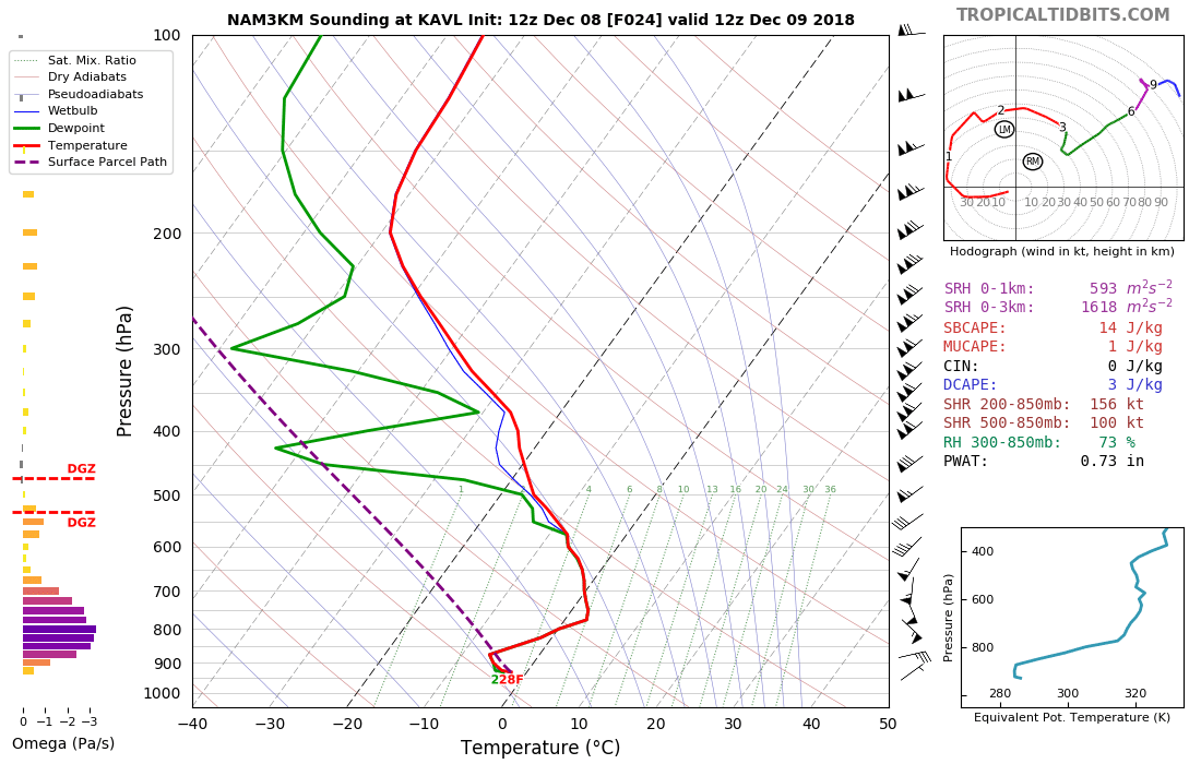
Uh oh. 3km NAM has 4-6 hours of sleet for Asheville overnight tonight, during the period of best forcing and maximum moisture. Bye bye snow totals. Time to sound the alarms. This is not an epic event or once in a generation event. Oh and 12Z NAM cuts QPF by 40-50% as well. Damn.

sorry HT, just disappointed I guess, didn't won't to hear that, very let down, I do appreciate your input muchly.
-
Was thinking from everything I see and just heard Jim Cantore say WNC will be snow and the warm nose comes in to play down around the piedmont.
-
GSP saying should be a mostly snow event was the latest forecast around Asheville.
-
Just now, BretWheatley said:
Damn!
surely not, must be a hiccup
-
56 minutes ago, HurricaneTracker said:
Ha ha ha. For now.....yes
Can't believe GSP has Asheville under a WSW and for 1 to 8 inches of snow during the event from start to end. I would have thought more like 12 to 20 during the whole event. That is unreal 1 to 8 inches. I mean with what the models keep coming out with that is a joke. I even see where winds will be gusting to 50 miles an hour at times, sounds more like Blizzard conditions. Most everything I've looked at and maps I've seen keeps from Hendersonville north mostly if not all snow during the whole event.
-
7 hours ago, SnoJoe said:
Nice win, but for the love of God, could someone just beat Alabama.
Rainy, drizzly, dark, foggy, breezy, miserable day. Counteracted by friends. spirits, fire, food, football, fellowship. I won.
Not a Alabama fan but I think they're the best team in the country once again.
-
Us in the south have about 100 things that can go wrong not to get a snowstorm and up in the midwest or northeast it snows at nothing.
Southeast Sanitarium - A Place to Vent
in Southeastern States
Posted
Hey is anyone else getting those pop ups everytime you go from one topic to the other, very annoying.