(002).png.f2cbd7c955dc3007a02ab79925b174ec.png)
ChescoWx
-
Posts
10,885 -
Joined
-
Last visited
Content Type
Profiles
Blogs
Forums
American Weather
Media Demo
Store
Gallery
Everything posted by ChescoWx
-
(002).thumb.png.6e3d9d46bca5fe41aab7a74871dd8af8.png)
E PA/NJ/DE Spring 2026 Obs/Discussion
ChescoWx replied to PhiEaglesfan712's topic in Philadelphia Region
More importantly just 6 days till Phillies opening day! Go Phillies!! -
Central PA Spring 2026 Discussion/Obs Thread
ChescoWx replied to Voyager's topic in Upstate New York/Pennsylvania
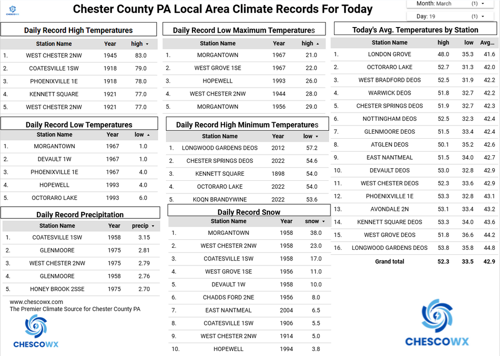
Today back in 1958 the area was in the middle of the 2nd greatest snowstorm in Pennsylvania history. Below are the all-time 3 day snowstorms across our state. The top 2 storms both were in our local area with the Blizzard of February 1899 at Coatesville with 52.4" and the 50.0" just off the PA Turnpike at Morgantown leading the way. Of note that same storm in 1958 also featured the 49" that was recorded just off the PA Turnpike at Devault. I have also included the hand written NWS COOP March 1958 observations for both Morgantown and Devault. -
E PA/NJ/DE Spring 2026 Obs/Discussion
ChescoWx replied to PhiEaglesfan712's topic in Philadelphia Region
Today back in 1958 the area was in the middle of the 2nd greatest snowstorm in Pennsylvania history. Below are the all-time 3 day snowstorms across our state. The top 2 storms both were in our local area with the Blizzard of February 1899 at Coatesville with 52.4" and the 50.0" just off the PA Turnpike at Morgantown leading the way. Of note that same storm in 1958 also featured the 49" that was recorded just off the PA Turnpike at Devault. I have also included the hand written NWS COOP March 1958 observations for both Morgantown and Devault. -
Central PA Spring 2026 Discussion/Obs Thread
ChescoWx replied to Voyager's topic in Upstate New York/Pennsylvania
Happy Spring Equinox at 10:46am to those that celebrate! Some folks think this means we have equal amounts of day and night lengths. While those are not far too far apart today (Sunrise 707am /Sunset 7:15pm) it in fact is when the Sun crosses the celestial equator. Five of our last 6 days have featured below normal temperatures but we will see temperatures well above normal today with highs near 60 degrees. We stay mild through the weekend with rain chances ramping up tonight and again on Sunday night. We turn sharply chillier again toward the middle of next week.
-
E PA/NJ/DE Spring 2026 Obs/Discussion
ChescoWx replied to PhiEaglesfan712's topic in Philadelphia Region
Happy Spring Equinox at 10:46am to those that celebrate! Some folks think this means we have equal amounts of day and night lengths. While those are not far too far apart today (Sunrise 707am /Sunset 7:15pm) it in fact is when the Sun crosses the celestial equator. Five of our last 6 days have featured below normal temperatures but we will see temperatures well above normal today with highs near 60 degrees. We stay mild through the weekend with rain chances ramping up tonight and again on Sunday night. We turn sharply chillier again toward the middle of next week.
-
Central PA Spring 2026 Discussion/Obs Thread
ChescoWx replied to Voyager's topic in Upstate New York/Pennsylvania
Some typical March weather ahead as we see consistent swings from cold to warmer to cold again for much of the rest of the month. We remain below normal today before warming up to above normal tomorrow through the weekend. WE then turn back to below normal to start the new work week. Our next rain chances arrive tomorrow night into Saturday morning and again Sunday night into Monday morning.
-
E PA/NJ/DE Spring 2026 Obs/Discussion
ChescoWx replied to PhiEaglesfan712's topic in Philadelphia Region
Some typical March weather ahead as we see consistent swings from cold to warmer to cold again for much of the rest of the month. We remain below normal today before warming up to above normal tomorrow through the weekend. WE then turn back to below normal to start the new work week. Our next rain chances arrive tomorrow night into Saturday morning and again Sunday night into Monday morning.
-
Central PA Spring 2026 Discussion/Obs Thread
ChescoWx replied to Voyager's topic in Upstate New York/Pennsylvania
Breezy and unseasonably cold weather today with some snow flurries possible this afternoon into the evening. There will be a hard freeze tonight so protect any plants that you may have put outside already. We will continue with below normal temperatures through Thursday (upper 30's to upper 40's) before we moderate to nearly normal both Friday and Saturday (low to mid 50's). Our next chance of rain or snow looks to possibly arrive on Friday night. We will fall back to below normal temperatures by next Monday. -
E PA/NJ/DE Spring 2026 Obs/Discussion
ChescoWx replied to PhiEaglesfan712's topic in Philadelphia Region
Changed to Snow here in NW Chesco with the temp down to 36.6 degrees -
E PA/NJ/DE Spring 2026 Obs/Discussion
ChescoWx replied to PhiEaglesfan712's topic in Philadelphia Region
Plenty of downed trees in the area - we had the power go out 5 times with the generator on and off. Temp down to 39.3 and the rain has changed to snow just to my west in NE Lancaster County -
E PA/NJ/DE Spring 2026 Obs/Discussion
ChescoWx replied to PhiEaglesfan712's topic in Philadelphia Region
The HRRR with sleet and snow accumulation later tonight -
E PA/NJ/DE Spring 2026 Obs/Discussion
ChescoWx replied to PhiEaglesfan712's topic in Philadelphia Region
0.68" of rain so far today may catch up to normal precip for the year by the end of this event! -
E PA/NJ/DE Spring 2026 Obs/Discussion
ChescoWx replied to PhiEaglesfan712's topic in Philadelphia Region
Great to see no severe so far !! Still need to watch that line with the front later this evening! -
E PA/NJ/DE Spring 2026 Obs/Discussion
ChescoWx replied to PhiEaglesfan712's topic in Philadelphia Region
Where could that front be at 11pm? -
E PA/NJ/DE Spring 2026 Obs/Discussion
ChescoWx replied to PhiEaglesfan712's topic in Philadelphia Region
Brief change to sleet and then snow on HRRR -
E PA/NJ/DE Spring 2026 Obs/Discussion
ChescoWx replied to PhiEaglesfan712's topic in Philadelphia Region
Let's hope so! -
E PA/NJ/DE Spring 2026 Obs/Discussion
ChescoWx replied to PhiEaglesfan712's topic in Philadelphia Region
I see my son's high school closed early. Let's all hope this falls apart well to the west and we get by with just some showers!! -
Central PA Spring 2026 Discussion/Obs Thread
ChescoWx replied to Voyager's topic in Upstate New York/Pennsylvania
We have picked up 0.43" of rain so far here in East Nantmeal since midnight. We could see upwards of another inch of rain by late tonight. Today will be unseasonably warm followed by unseasonably cold tomorrow through Thursday. A wind advisory is in effect for wind gusts as high as 40 mph through tonight. A strong cold front will cross the area from west to east around the 9pm tonight. Temperatures will drop close to 20 degrees over an hour or so. Rain could briefly turn to sleet and then snow before ending. Temperatures return to near normal by next weekend. -
E PA/NJ/DE Spring 2026 Obs/Discussion
ChescoWx replied to PhiEaglesfan712's topic in Philadelphia Region
We have picked up 0.43" of rain so far here in East Nantmeal since midnight. We could see upwards of another inch of rain by late tonight. Today will be unseasonably warm followed by unseasonably cold tomorrow through Thursday. A wind advisory is in effect for wind gusts as high as 40 mph through tonight. A strong cold front will cross the area from west to east around the 9pm tonight. Temperatures will drop close to 20 degrees over an hour or so. Rain could briefly turn to sleet and then snow before ending. Temperatures return to near normal by next weekend. -
Central PA Spring 2026 Discussion/Obs Thread
ChescoWx replied to Voyager's topic in Upstate New York/Pennsylvania
Today should be the calm before the storm. We see temperatures close to normal today in the lower 50's before rain arrives this evening. We have a chance to actually move to above normal precipitation for the year with between 1" to 1.75" of rain possible across the area. There will be a severe weather threat tomorrow especially with a strong cold frontal passage tomorrow evening. We could see temperatures fall by over 25 degrees over just a couple hours after highs well into 60's. Rain will possibly mix with or change to some brief snow before ending by Tuesday morning. We will see well below normal temperatures both Tuesday and Wednesday before we return to slightly below normal temperatures for the rest of the work week. -
E PA/NJ/DE Spring 2026 Obs/Discussion
ChescoWx replied to PhiEaglesfan712's topic in Philadelphia Region
Today should be the calm before the storm. We see temperatures close to normal today in the lower 50's before rain arrives this evening. We have a chance to actually move to above normal precipitation for the year with between 1" to 1.75" of rain possible across the area. There will be a severe weather threat tomorrow especially with a strong cold frontal passage tomorrow evening. We could see temperatures fall by over 25 degrees over just a couple hours after highs well into 60's. Rain will possibly mix with or change to some brief snow before ending by Tuesday morning. We will see well below normal temperatures both Tuesday and Wednesday before we return to slightly below normal temperatures for the rest of the work week. -
Central PA Spring 2026 Discussion/Obs Thread
ChescoWx replied to Voyager's topic in Upstate New York/Pennsylvania
Continued breezy today and tomorrow with below normal temperatures not far from 50 degrees. We briefly warm on Monday with highs well into the 60's before a strong cold front crosses the area not too long after the evening rush hour. Rain chances to ramp up tomorrow night with over an inch possible by later Monday. We could see some severe weather Monday evening. With the cold frontal passage Monday night, we could again see rain changing to wet snow with temperatures dropping over 20 degrees over a couple of hours. Tuesday and Wednesday will be unseasonably cold with highs barely above freezing on Tuesday and remaining in the 30's on Wednesday. -
E PA/NJ/DE Spring 2026 Obs/Discussion
ChescoWx replied to PhiEaglesfan712's topic in Philadelphia Region
Continued breezy today and tomorrow with below normal temperatures not far from 50 degrees. We briefly warm on Monday with highs well into the 60's before a strong cold front crosses the area not too long after the evening rush hour. Rain chances to ramp up tomorrow night with over an inch possible by later Monday. We could see some severe weather Monday evening. With the cold frontal passage Monday night, we could again see rain changing to wet snow with temperatures dropping over 20 degrees over a couple of hours. Tuesday and Wednesday will be unseasonably cold with highs barely above freezing on Tuesday and remaining in the 30's on Wednesday. -
Central PA Spring 2026 Discussion/Obs Thread
ChescoWx replied to Voyager's topic in Upstate New York/Pennsylvania
With yesterday's 0.5" of snow, we have now recorded measurable snow in each of the last 5 months from November through March. This is the 6th time that has happened in the last 23 seasons here in East Nantmeal Township. While we have recorded measurable April snow 7 times since 2004 (including last April) we have never recorded snow in 6 consecutive months. No snow in our future at least till Monday night but below normal temperatures both today and tomorrow before near normal (low 50's) highs on Sunday. We warm briefly to well above normal Monday before a strong cold front crosses the area with some potential for severe weather and another potential change to some wet snow before ending on Monday night. Unseasonably cold weather through much of next week appears likely.