(002).png.f2cbd7c955dc3007a02ab79925b174ec.png)
ChescoWx
-
Posts
10,961 -
Joined
-
Last visited
Content Type
Profiles
Blogs
Forums
American Weather
Media Demo
Store
Gallery
Everything posted by ChescoWx
-
(002).thumb.png.6e3d9d46bca5fe41aab7a74871dd8af8.png)
Central PA Spring 2026 Discussion/Obs Thread
ChescoWx replied to Voyager's topic in Upstate New York/Pennsylvania
We have some light rain around this morning here in NW Chester County a cool day is on tap with some showers. Highs will struggle to reach the lower 60's. Nice but brief warm up tomorrow for Mom's Day with highs reaching the mid 70's with sunshine. Much cooler again with below normal temperatures all week. We will have additional rain chances both Sunday night and Monday and again Wednesday through Friday.

-
E PA/NJ/DE Spring 2026 Obs/Discussion
ChescoWx replied to PhiEaglesfan712's topic in Philadelphia Region
We have some light rain around this morning here in NW Chester County a cool day is on tap with some showers. Highs will struggle to reach the lower 60's. Nice but brief warm up tomorrow for Mom's Day with highs reaching the mid 70's with sunshine. Much cooler again with below normal temperatures all week. We will have additional rain chances both Sunday night and Monday and again Wednesday through Friday.
-
Central PA Spring 2026 Discussion/Obs Thread
ChescoWx replied to Voyager's topic in Upstate New York/Pennsylvania
Minimum temperatures this morning were 8 to 14 degrees below normal for today’s date. The lowest was our typical cold spot in Warwick Twp with a low of 35.5. With the exception of Sunday, where temperatures will be close to normal with highs in the low 70’s we should see well below normal temperatures continue for at least the next week. Rain chances increase tomorrow morning into the afternoon. We should see a mostly sunny Mom’s Day on Sunday before more rain arrives Sunday night into Monday. Some models are hinting at almost an inch of rain between Saturday and Monday night.
-
E PA/NJ/DE Spring 2026 Obs/Discussion
ChescoWx replied to PhiEaglesfan712's topic in Philadelphia Region
Nice write up! our climate has always and will always move in cycles. Of note with May likely to end with below normal temperatures - this will mark 7 of the last 10 months with below average temperatures here in Chester County. -
Central PA Spring 2026 Discussion/Obs Thread
ChescoWx replied to Voyager's topic in Upstate New York/Pennsylvania
Ten of our last fifteen days have featured below normal temperatures. It looks like much of the next 15 days will also average out with cooler than normal temperatures. After some much needed rain last night we have a great day underway today. Below normal temperatures will continue through Saturday. Rain chances increase again toward Saturday morning before we briefly warm to above normal on Sunday for Mom’s day with highs in the middle 70’s. We turn sharply cooler again to start the new work week.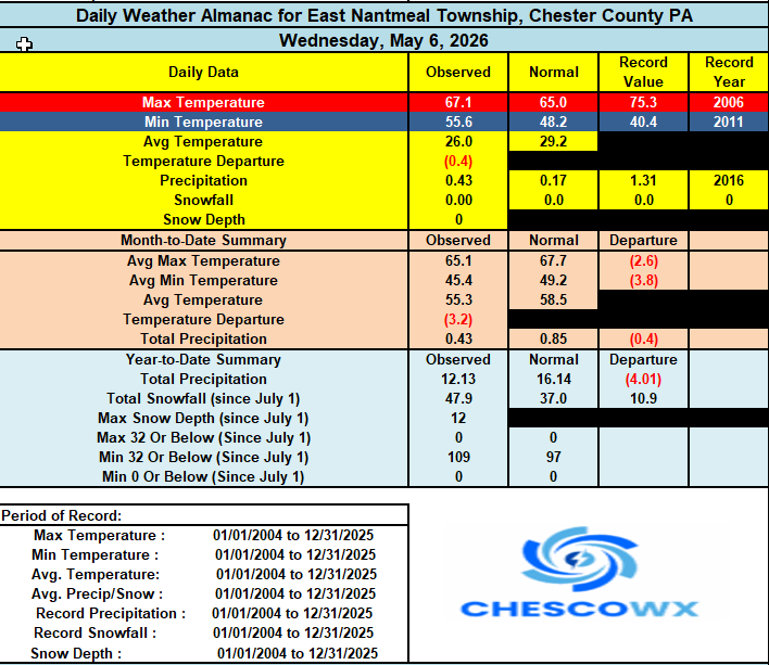
-
E PA/NJ/DE Spring 2026 Obs/Discussion
ChescoWx replied to PhiEaglesfan712's topic in Philadelphia Region
Ten of our last fifteen days have featured below normal temperatures. It looks like much of the next 15 days will also average out with cooler than normal temperatures. After some much needed rain last night we have a great day underway today. Below normal temperatures will continue through Saturday. Rain chances increase again toward Saturday morning before we briefly warm to above normal on Sunday for Mom’s day with highs in the middle 70’s. We turn sharply cooler again to start the new work week.
-
Central PA Spring 2026 Discussion/Obs Thread
ChescoWx replied to Voyager's topic in Upstate New York/Pennsylvania
Cooler today with showers we could see up to 0.25" of needed rain. We are at 73% of normal rainfall for the year to date. We remain cooler than normal through Saturday with a brief warmup on Sunday to above normal before temperatures again fall below normal. Overall, the next couple weeks look to average below normal. Our next shower chances will be Saturday.
-
E PA/NJ/DE Spring 2026 Obs/Discussion
ChescoWx replied to PhiEaglesfan712's topic in Philadelphia Region
Cooler today with showers we could see up to 0.25" of needed rain. We are at 73% of normal rainfall for the year to date. We remain cooler than normal through Saturday with a brief warmup on Sunday to above normal before temperatures again fall below normal. Overall, the next couple weeks look to average below normal. Our next shower chances will be Saturday.
-
Central PA Spring 2026 Discussion/Obs Thread
ChescoWx replied to Voyager's topic in Upstate New York/Pennsylvania
Many lower spots reached the 30's this morning with the Warwick DEOS the chilliest at 30.9 degrees. We warm up nicely today to near normal highs around 70 today. We warm to close to 80 degrees tomorrow before we start another cooling trend. Shower chances also look to increase Wednesday into Thursday before we clear up on Friday. Below normal temperatures look likely from Thursday through the weekend.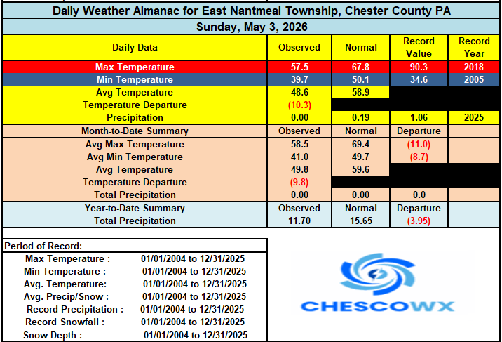
-
E PA/NJ/DE Spring 2026 Obs/Discussion
ChescoWx replied to PhiEaglesfan712's topic in Philadelphia Region
Many lower spots reached the 30's this morning with the Warwick DEOS the chilliest at 30.9 degrees. We warm up nicely today to near normal highs around 70 today. We warm to close to 80 degrees tomorrow before we start another cooling trend. Shower chances also look to increase Wednesday into Thursday before we clear up on Friday. Below normal temperatures look likely from Thursday through the weekend.
-
Central PA Spring 2026 Discussion/Obs Thread
ChescoWx replied to Voyager's topic in Upstate New York/Pennsylvania
Below is from Mount Holly - Is there one from State College? Thanks! -
E PA/NJ/DE Spring 2026 Obs/Discussion
ChescoWx replied to PhiEaglesfan712's topic in Philadelphia Region
Final seasonal NWS reported snowfall maps -
Central PA Spring 2026 Discussion/Obs Thread
ChescoWx replied to Voyager's topic in Upstate New York/Pennsylvania
Another below normal temperature day on tap today before we see a brief warm up with some valley locations touching 80 degrees by Tuesday before we turn much chillier again by the end of the week. Highs by Thursday through Saturday may struggle to escape the upper 50's. Rain chances increase with a cold front by Tuesday night.
-
E PA/NJ/DE Spring 2026 Obs/Discussion
ChescoWx replied to PhiEaglesfan712's topic in Philadelphia Region
Another below normal temperature day on tap today before we see a brief warm up with some valley locations touching 80 degrees by Tuesday before we turn much chillier again by the end of the week. Highs by Thursday through Saturday may struggle to escape the upper 50's. Rain chances increase with a cold front by Tuesday night.
-
Welp I guess if our climate began in 1980 there could be a story there....
-
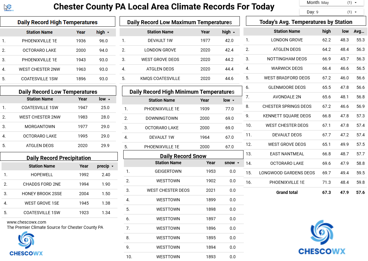
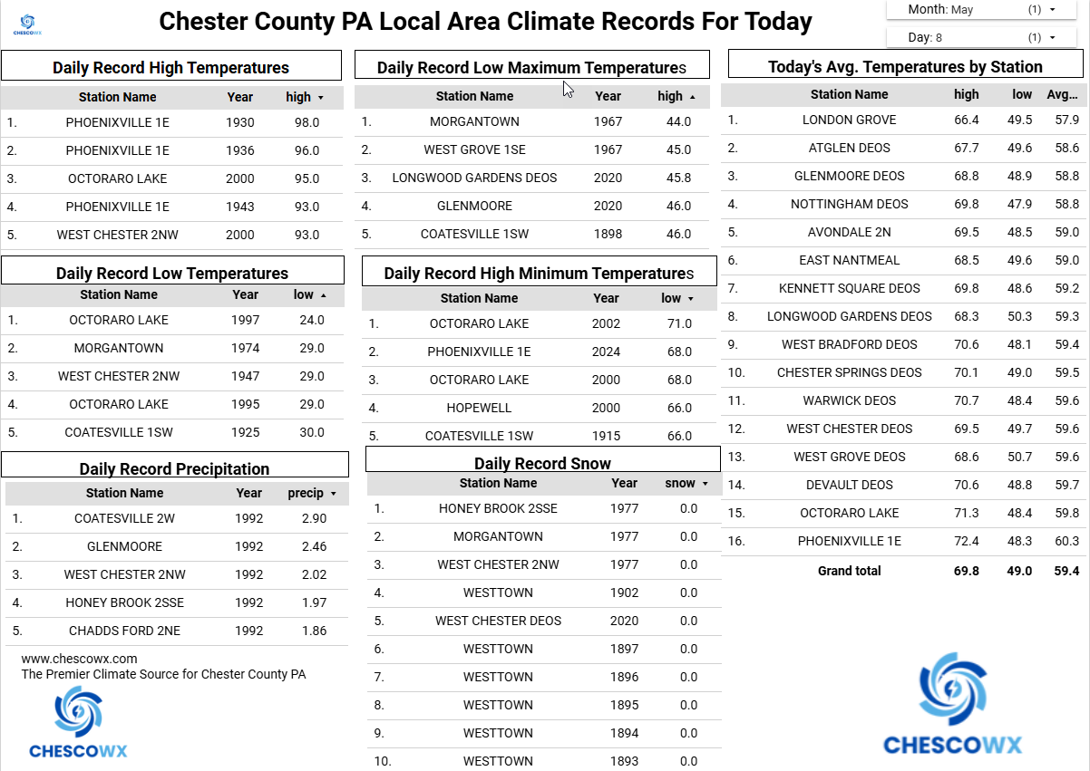
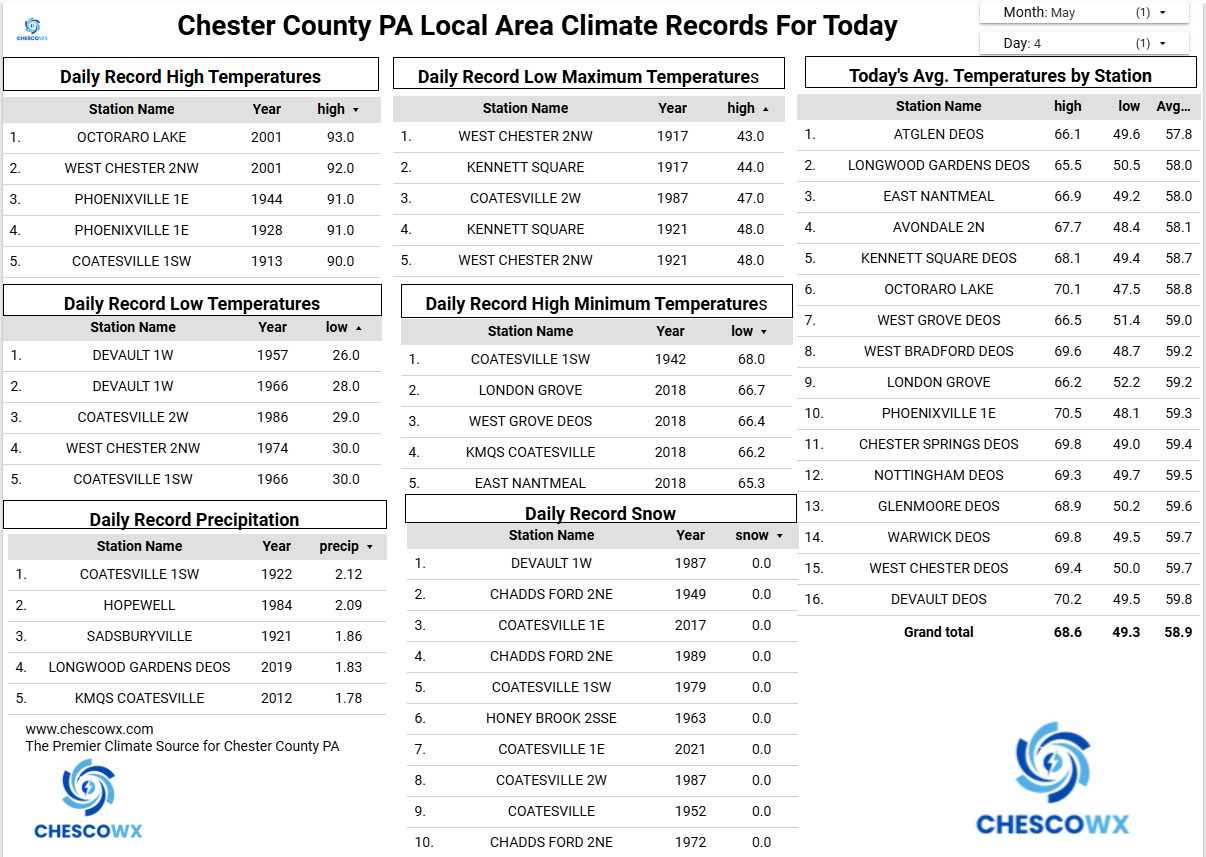
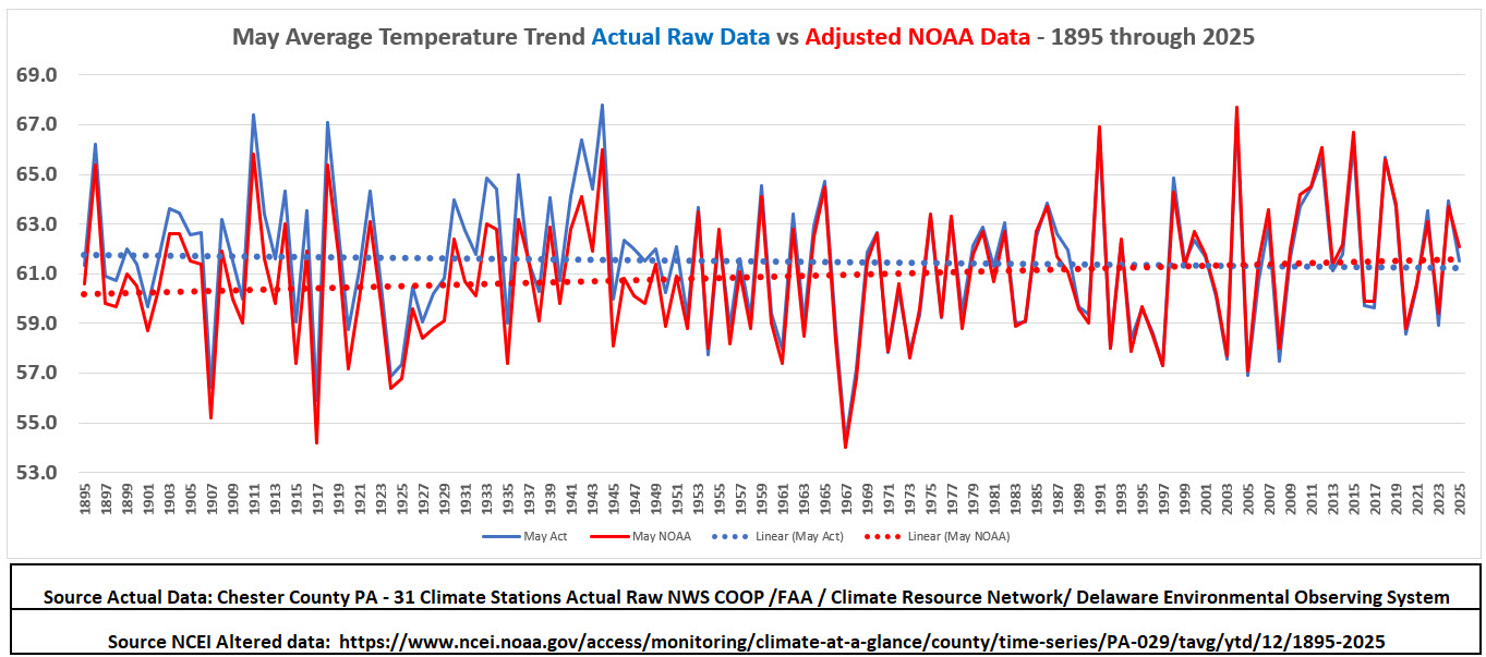
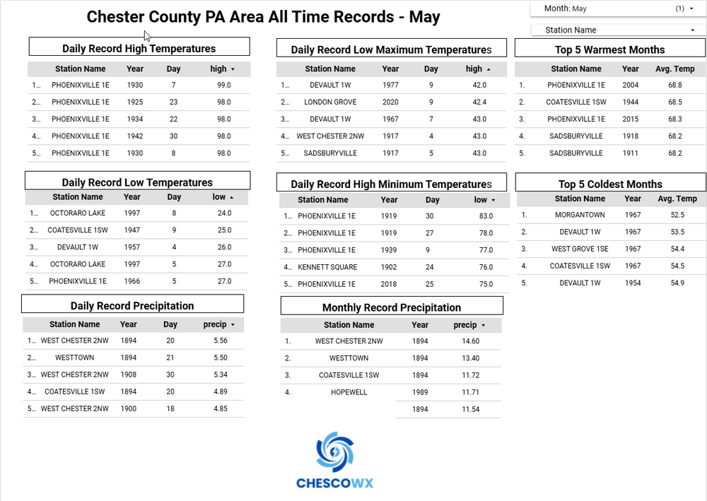
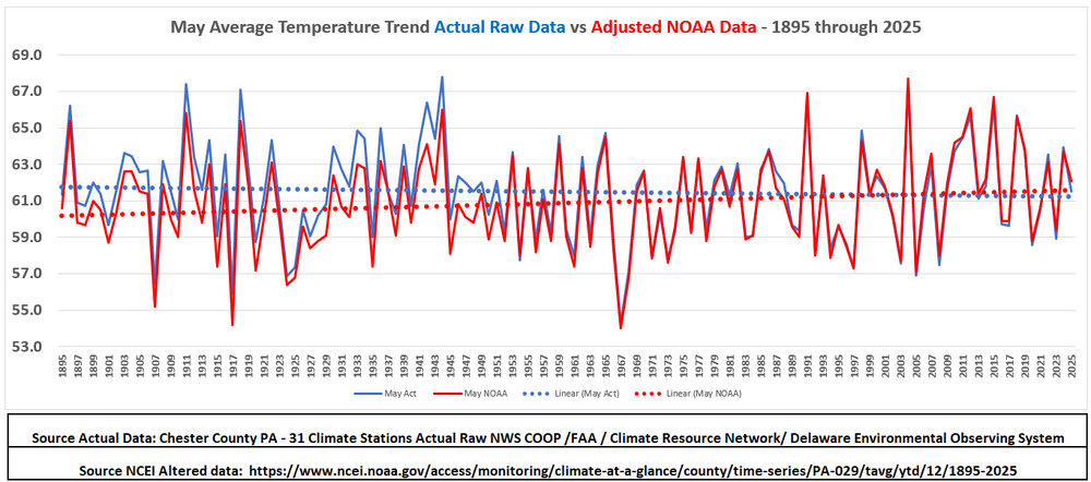
Below for the Philly burbs of Chester County PA are the all-time May climate records and below that the climate trends for the month. Based on the actual historical data (blue) our average May temperatures show a slight cooling trend since 1893 while the adjusted NCEI (red) temperatures indicate a very slight warming trendline.
-
LOL!! but it is the only 134 years of data we have for this beautiful county of Chester....so we analyze!!!
-
Central PA Spring 2026 Discussion/Obs Thread
ChescoWx replied to Voyager's topic in Upstate New York/Pennsylvania
Below for the Philly burbs of Chester County PA are the all-time May climate records and below that the climate trends for the month. Based on the actual historical data (blue) our average May temperatures show a slight cooling trend since 1893 while the adjusted NCEI (red) temperatures indicate a very slight warming trendline.
-
E PA/NJ/DE Spring 2026 Obs/Discussion
ChescoWx replied to PhiEaglesfan712's topic in Philadelphia Region
Below for the Philly burbs of Chester County PA are the all-time May climate records and below that the climate trends for the month. Based on the actual historical data (blue) our average May temperatures show a slight cooling trend since 1893 while the adjusted NCEI (red) temperatures indicate a very slight warming trendline.
-
Central PA Spring 2026 Discussion/Obs Thread
ChescoWx replied to Voyager's topic in Upstate New York/Pennsylvania
April finished as the 12th warmest (POR 133 years) first month of spring here in Chester County PA below are the Top 20 warm years. Our average of 55.0 was +2.8 degrees above our 1991-2020 climate normal of 52.2 degrees. January thru April 2026 is the 57th warmest first 4 months of a yea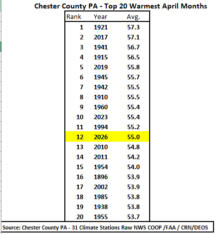
-
E PA/NJ/DE Spring 2026 Obs/Discussion
ChescoWx replied to PhiEaglesfan712's topic in Philadelphia Region
April finished as the 12th warmest (POR 133 years) first month of spring here in Chester County PA below are the Top 20 warm years. Our average of 55.0 was +2.8 degrees above our 1991-2020 climate normal of 52.2 degrees. January thru April 2026 is the 57th warmest first 4 months of a yea
-
I simply posed a question I did not say it was proof of anything...I unlike some understand when the n is way too short - LOL!!
-
Central PA Spring 2026 Discussion/Obs Thread
ChescoWx replied to Voyager's topic in Upstate New York/Pennsylvania
Today will be our 7th consecutive below normal temperature day with our temperatures remaining below normal through this weekend before we warm to above normal by Tuesday. We then turn cooler again for the rest of the first week of May. Overall, the long-range models see a chillier than normal month with some models continuing the relative chill into June. We have some slight shower chances tonight with rain chances increasing toward the middle of next week.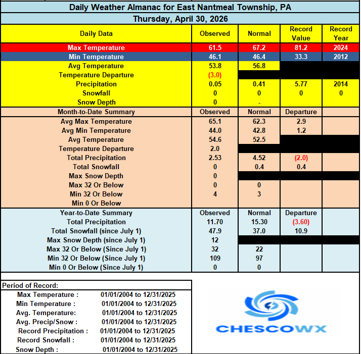

-
E PA/NJ/DE Spring 2026 Obs/Discussion
ChescoWx replied to PhiEaglesfan712's topic in Philadelphia Region
Today will be our 7th consecutive below normal temperature day with our temperatures remaining below normal through this weekend before we warm to above normal by Tuesday. We then turn cooler again for the rest of the first week of May. Overall, the long-range models see a chillier than normal month with some models continuing the relative chill into June. We have some slight shower chances tonight with rain chances increasing toward the middle of next week.