snowfan
-
Posts
9,908 -
Joined
-
Last visited
Content Type
Profiles
Blogs
Forums
American Weather
Media Demo
Store
Gallery
Everything posted by snowfan
-
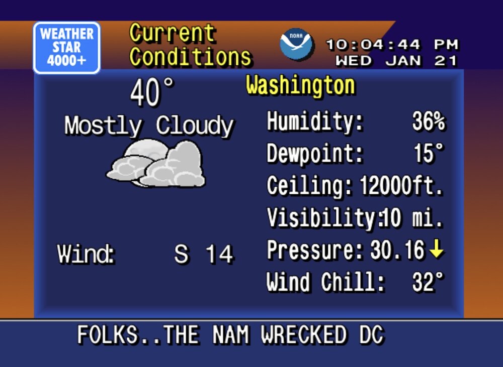
Damn….this isn’t even all the way out there in fantasy land.

-
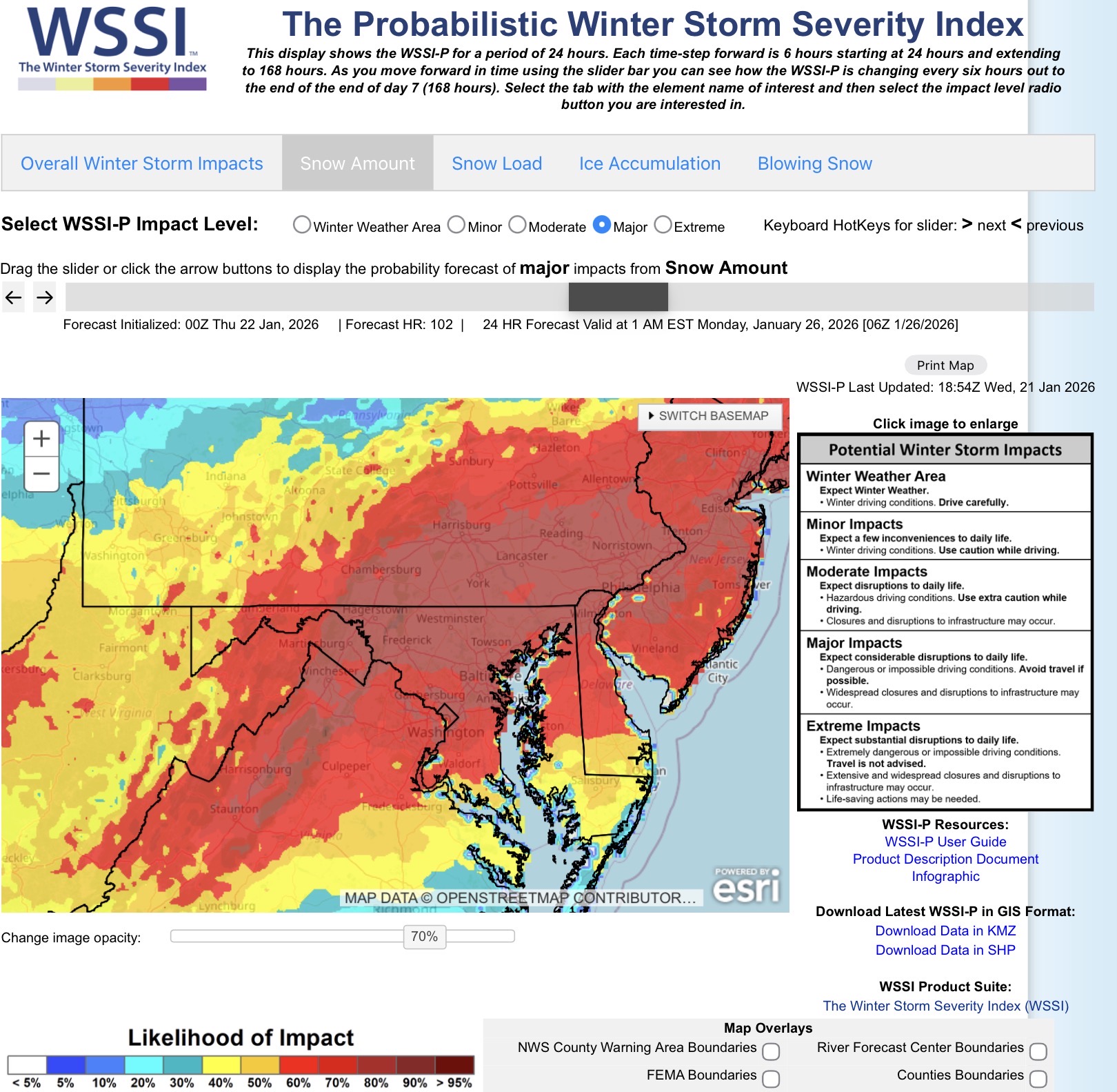
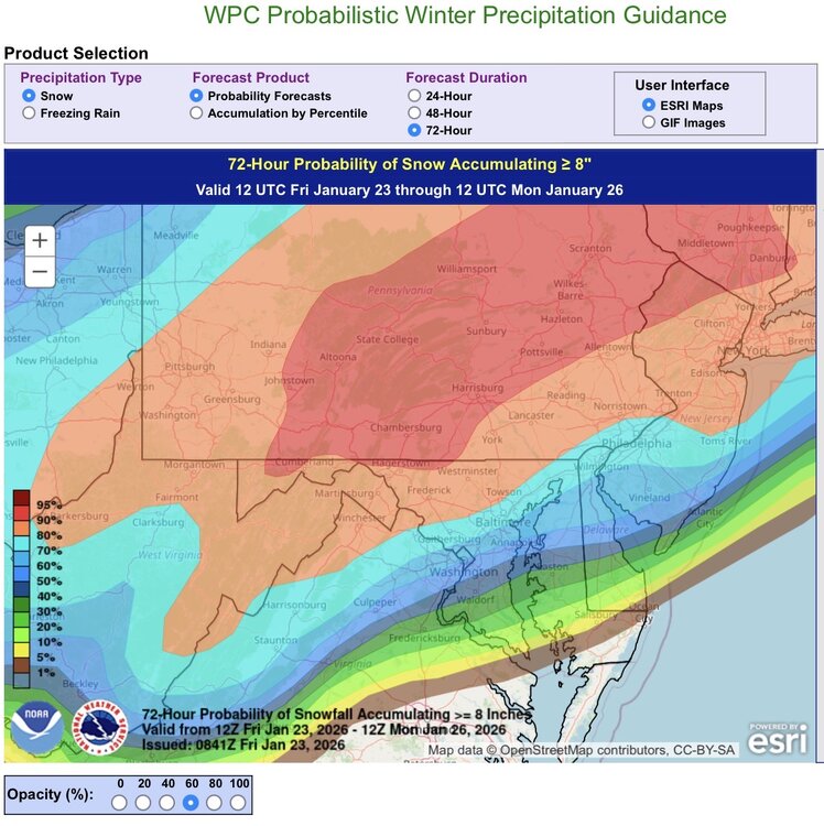
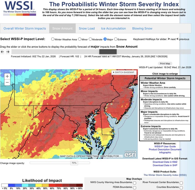
Updated percentage chance of hitting or exceeding 8” snowfall before flipping. For reference, DCA is at the 50% threshold.
-

January 24-26: Miracle or Mirage JV/Banter Thread!
snowfan replied to SnowenOutThere's topic in Mid Atlantic
I like to look back at old storm pics. Here's one from the 2016 storm looking out late at night.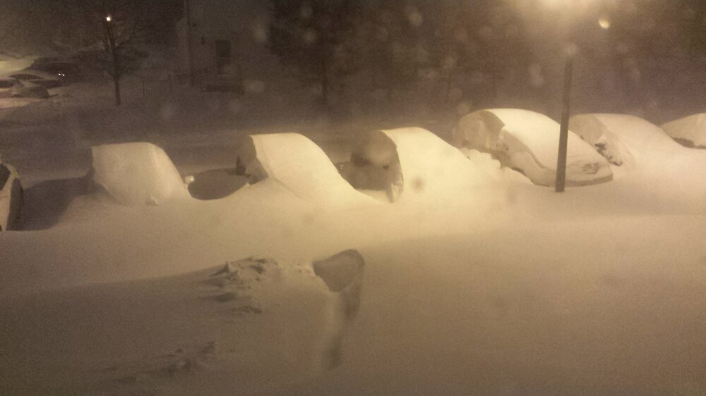
-
January 24-26: Miracle or Mirage JV/Banter Thread!
snowfan replied to SnowenOutThere's topic in Mid Atlantic
@mappyisn't paid enough (or at all) by @stormtrackerto deal with the drama over there -
January 24-26: Miracle or Mirage JV/Banter Thread!
snowfan replied to SnowenOutThere's topic in Mid Atlantic
Nice....I've got 2 of those of my shelf rn. -
January 24-26: Miracle or Mirage JV/Banter Thread!
snowfan replied to SnowenOutThere's topic in Mid Atlantic
Hey man, have you tried their deep orbit stout that's out right now? Talk about a sipper.....could enjoy that thing over an hour in front of the fire. -
The Ravens just like to hire people associated with Jim, John and Michigan.
-
January 24-26: Miracle or Mirage JV/Banter Thread!
snowfan replied to SnowenOutThere's topic in Mid Atlantic
GFS is giving many well over an inch liquid w a backside flip and ppl are hating. -
January 24-26: Miracle or Mirage JV/Banter Thread!
snowfan replied to SnowenOutThere's topic in Mid Atlantic
No you're good. -
January 24-26: Miracle or Mirage JV/Banter Thread!
snowfan replied to SnowenOutThere's topic in Mid Atlantic
Pbp is legit atrocious from some over there. -
January 24-26: Miracle or Mirage JV/Banter Thread!
snowfan replied to SnowenOutThere's topic in Mid Atlantic
CWG has me getting 2-15" -
January 24-26: Miracle or Mirage JV/Banter Thread!
snowfan replied to SnowenOutThere's topic in Mid Atlantic
People blowing off the nam thermals are just ignoring history. -
January 24-26: Miracle or Mirage JV/Banter Thread!
snowfan replied to SnowenOutThere's topic in Mid Atlantic
Back in the day, CWG just annoyed me when they'd get all hell bent on 2nd guessing local school operating decisions (stay in your lane), then they shifted to competing with LWX and taking petty shots at them, and now they just generally suck. -
Its overdone, but it will definitely be cold.
-
-
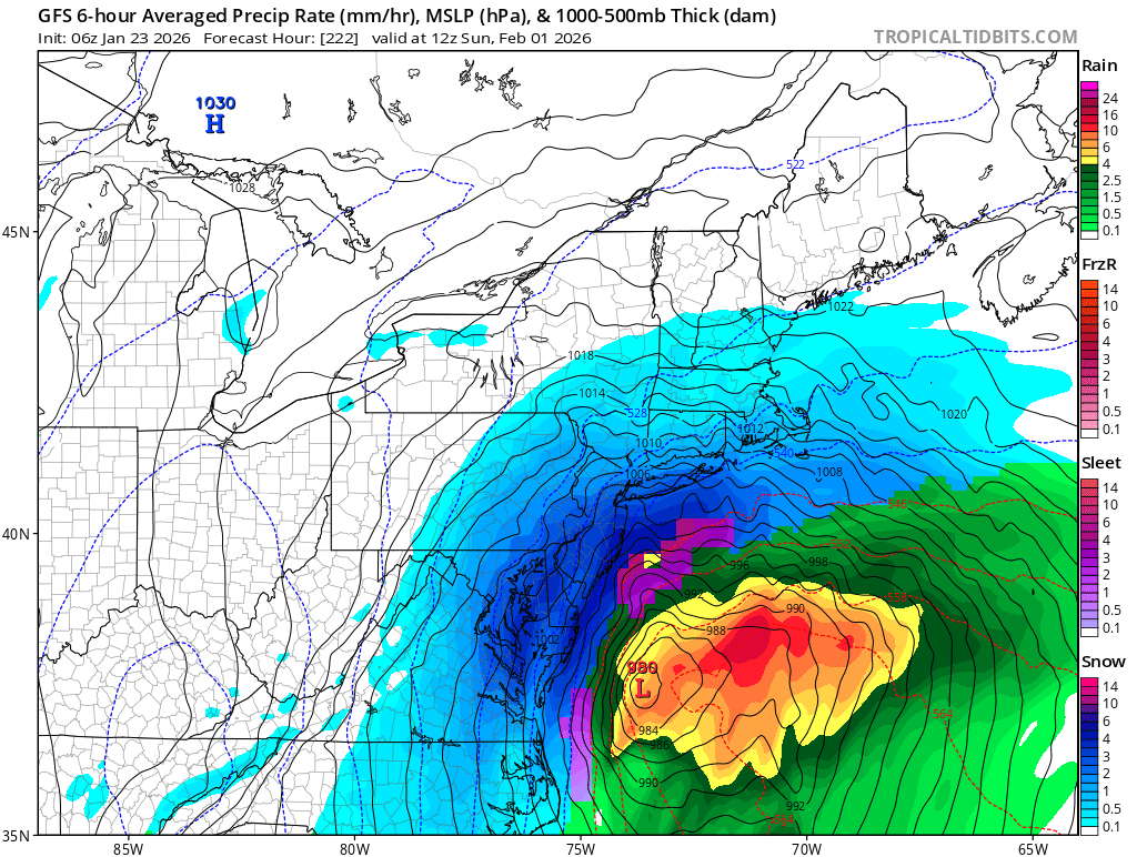
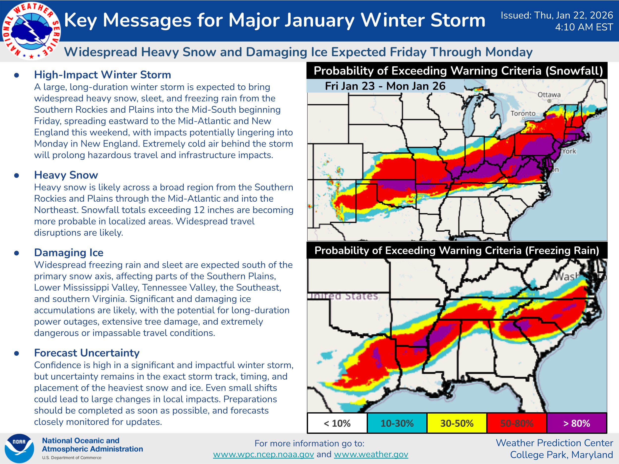
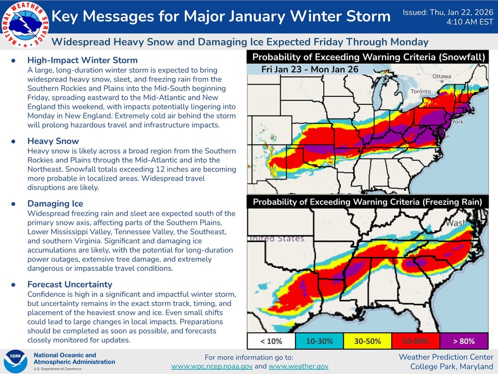
Here’s a snippet from the latest winter wx discussion from WPC One area that is slowly becoming the most favorable location forheavy snowfall rates and potentially the most impressive snowfallamounts is the central Appalachians, northern VA, MD, and southernPA through early Sunday. As the upper level trough deepens over thecentral U.S. Saturday night, mid- level flow begins to increaseout ahead of it and meets the mid-level warm front stretching fromthe eastern Ohio Valley into the Mid- Atlantic. Several 00z modelshighlight increasing 700mb fgen over the eastern Ohio Valley andinto central VA by late D3, which supports the potential for anextended period of 1"/hr rates across much of eastern WV,central/northern VA, MD, and southern PA. The 0C warm nose maybegin to approach northern VA by the end of D3, but areas just tothe north could see 6-12" by sunrise on Sunday as precipitationlingering further into the day on Sunday. Snow ratios will also befavorable at onset and could potentially exceed 20:1 withinenhanced banding, which is well above the 11:1 climatology in theregion. Current WPC probabilities through D3 are medium to high(40-70%) for at least 8" of snow, this includes areas just west ofI-95 from D.C. to Baltimore. Heavy snow is expected to continuestretching into the Northeast and New England on Sunday, see WPC'sExtended Forecast Discussion for more. Also, see the Key Messageslinked at the bottom of this discussion.
-
-
Good background info from Jeremy on winter recon.... https://x.com/i/status/2014061179061092580
-
January 24-26: Miracle or Mirage JV/Banter Thread!
snowfan replied to SnowenOutThere's topic in Mid Atlantic
I’m ingesting a barrel aged stout -
January 24-26: Miracle or Mirage JV/Banter Thread!
snowfan replied to SnowenOutThere's topic in Mid Atlantic
In all seriousness though, a number agencies….fed and state/local are actively staging resources to respond to this. Lots of planning calls today. -
-
January 24-26: Miracle or Mirage JV/Banter Thread!
snowfan replied to SnowenOutThere's topic in Mid Atlantic

-
January 24-26: Miracle or Mirage JV/Banter Thread!
snowfan replied to SnowenOutThere's topic in Mid Atlantic
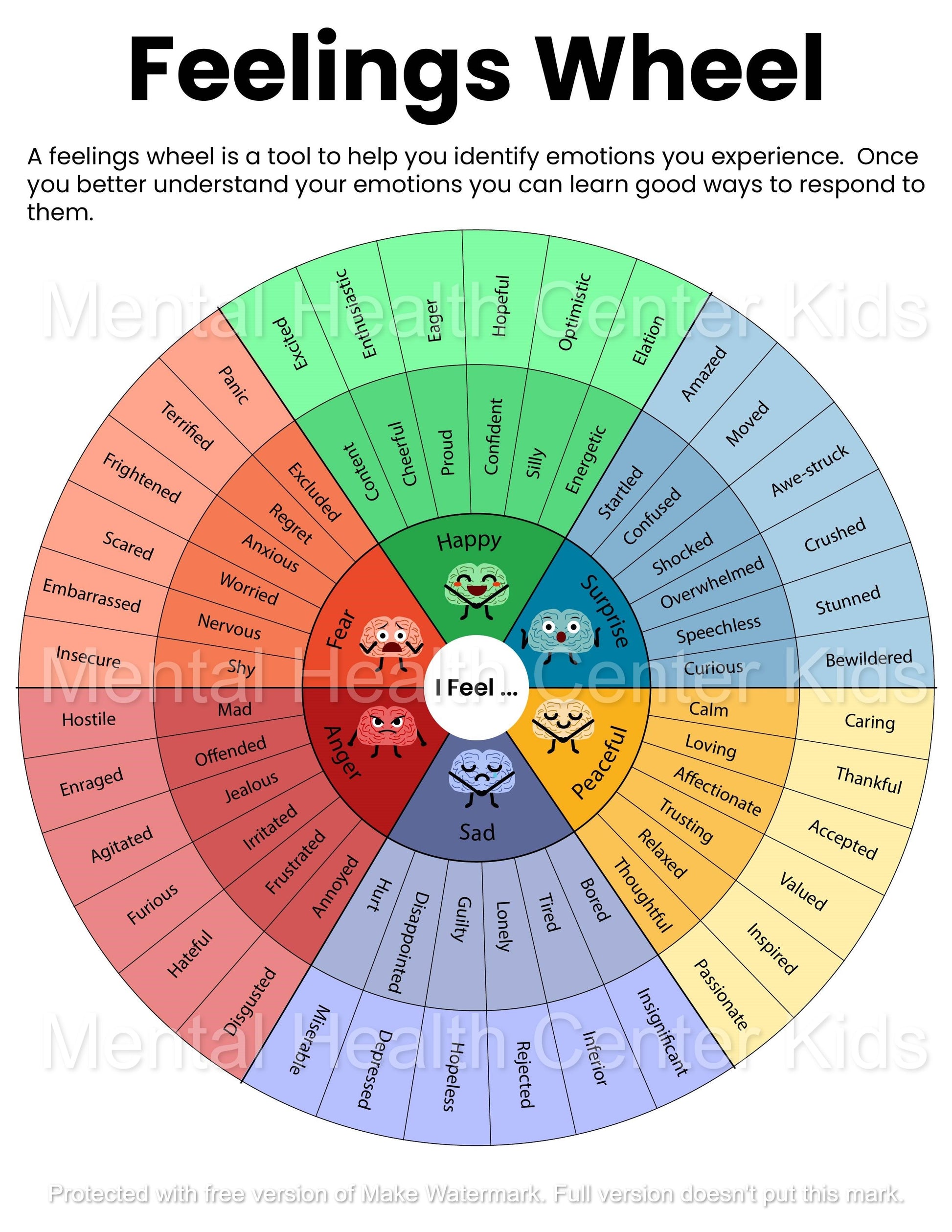
The feelings wheel brought to you by the storm thread.
-
You don't need any of that info in the real world so don't sweat it.
-
Nearly 20 years in on these boards and pbp/reaction during big events never changes lol.