

CoastalWx
-
Posts
176,935 -
Joined
-
Last visited
Content Type
Profiles
Blogs
Forums
American Weather
Media Demo
Store
Gallery
Everything posted by CoastalWx
-
Significant upper middle Atlantic S/CNE mix/snow potential Jan 3+
CoastalWx replied to Typhoon Tip's topic in New England
Edibles? -
Significant upper middle Atlantic S/CNE mix/snow potential Jan 3+
CoastalWx replied to Typhoon Tip's topic in New England
12z eps just started now. -
Significant upper middle Atlantic S/CNE mix/snow potential Jan 3+
CoastalWx replied to Typhoon Tip's topic in New England
Wish we could lock -
Dec (Edit: Jan1/..2 ) multi-faceted ptype mess potential...
CoastalWx replied to Typhoon Tip's topic in New England
-
Dec (Edit: Jan1/..2 ) multi-faceted ptype mess potential...
CoastalWx replied to Typhoon Tip's topic in New England
So maybe don't need the genny's for CT? -
Significant upper middle Atlantic S/CNE mix/snow potential Jan 3+
CoastalWx replied to Typhoon Tip's topic in New England
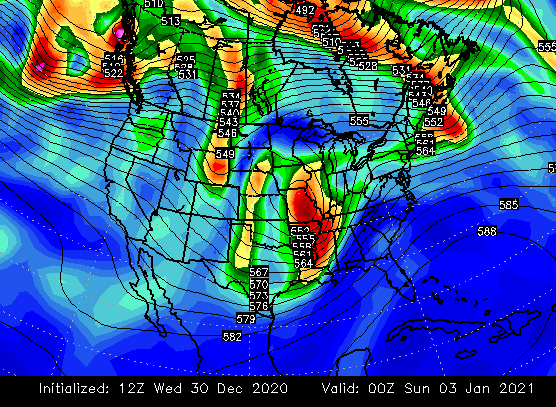
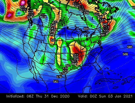
You can see how the 6z run on the right definitely is slower and more amped at 500 as it leaves New England. -
Significant upper middle Atlantic S/CNE mix/snow potential Jan 3+
CoastalWx replied to Typhoon Tip's topic in New England
-
Significant upper middle Atlantic S/CNE mix/snow potential Jan 3+
CoastalWx replied to Typhoon Tip's topic in New England
Might need rigorous vetting for his obs. -
Yeah Steve is right. It can be underdone a bit.
-
Significant upper middle Atlantic S/CNE mix/snow potential Jan 3+
CoastalWx replied to Typhoon Tip's topic in New England
Nah not yet here lol. But all good. I’d probably open them a little more inland. Maybe even Ray as long as he didn’t rip them off the wall last night. -
It’s all an interesting mental game. Weenies generally adhere to those posting favorable thoughts. They hate when you talk about caution flags or anything unfavorable.
-
Significant upper middle Atlantic S/CNE mix/snow potential Jan 3+
CoastalWx replied to Typhoon Tip's topic in New England
Yeah it’s dicey here, but good to see the improvement. If it ends as some snow, I’d take it and run. Hopefully a trend there. -
Significant upper middle Atlantic S/CNE mix/snow potential Jan 3+
CoastalWx replied to Typhoon Tip's topic in New England
EPS looked good I thought. If you compare it to the 12z EPS, that vorticity lobe we all spoke about develops quicker as it ejects out, under SNE. -
Dec (Edit: Jan1/..2 ) multi-faceted ptype mess potential...
CoastalWx replied to Typhoon Tip's topic in New England
LookS good to me. -
EPS had it backing up too. Good to see.
-
Dec (Edit: Jan1/..2 ) multi-faceted ptype mess potential...
CoastalWx replied to Typhoon Tip's topic in New England
Note graphics may be fuzzy at times. -
Don’t forget the sun angle is increasing.
-
Probably a pattern more for you into NNE next two weeks I think. At least that’s what I would favor.
-
He might be right
-
But yeah I see what you mean, Will. Maybe timing issues.
-
Oh I don’t mean a closed block or anything, just a semblance of a ridge....some sort of curvature. Even with a smoothed out mean. I think we have ridging, just not sure how strong.
-
Yeah that’s what I hope, we get a decent block there. Going to need strong blocking too until Pacific gets better.
-
Well I explained it a few days ago. But basically the warm pacific air causes the heights to be well above normal. So as a result you get those big reds and whites that look like Massive + anomalies. But, you can tell it may be sort of masking what may be occurring, because there is no anticyclonic curvature. The key to seeing this, are the more zonal looking height lines as shown below. Ryan also said this too. Imo, there is ridging, however I’m not sold on it looking as strong as it shows based on those height anomalies. This actually is common in El Niño’s. So we’ll see as we get closer. I know it may be a smoother out mean beyond 10 days, but I am keeping an eye on it. Just something to watch.
-
Getting back to the blocking, I’m still thinking the pacific air may be creating a false blocking signal, or at least making it look stronger than it might be. On the EPS, I still don’t see a big stout anticyclone up near the Davis Straits. I’m not saying it’s completely gone, just that I’m not sold on a big block yet. The Pacific, however, is improving quite a bit.
-
Dec (Edit: Jan1/..2 ) multi-faceted ptype mess potential...
CoastalWx replied to Typhoon Tip's topic in New England
18z nam a little more snowier near MA/NH border.


