CoastalWx
-
Posts
176,941 -
Joined
-
Last visited
Content Type
Profiles
Blogs
Forums
American Weather
Media Demo
Store
Gallery
Everything posted by CoastalWx
-
I don't know, congrats DC.
-
Squashed
-
Nice little band north of Albany. Should keep Dendrite happy and not have him choke out his chickens.
-
That two max thing may be showing up already. Stuff near SNE coast looks more aggressive then guidance is showing.
-
I doubt that.
-
The warnings seems aggressive for such a large area. Maybe a narrow area gets it?
-
This week is squashed. euro looks like a light to moderate snow event for VD.
-
Yeah this almost looks like it could have two small max zones like Will said. Maybe one near better low level WAA and then the other near NH border with the mid level fronto.
-
Gfs is like 4-6” over SNE.
-
Anything the faces south gets torched now.
-
Yep, love to see it.
-
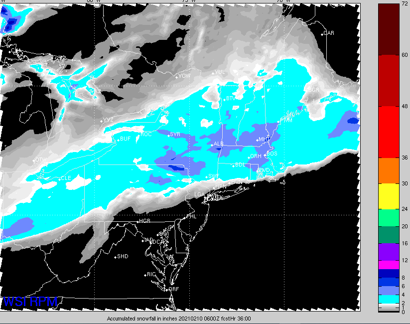
RPM is interesting. Gets a slug of moisture involved from the south and drops several inches region wide.
-
Weeklies look nice. Cooled off from last week which wasn’t bad at all.
-
Nam looks nice
-
All La Niña winters start in Feb.
-
EPS looks great. Lock it In.
-
Dendrite.
-
We squash?
-
What event?
-
Kuchie Koo?
-
When lift moves through the DGZ (-12C to -18C) and it’s saturated. That’s the recipe for beautiful dendrites that accumulate efficiently.
-
Another event with very little wind.
-
Friday squashed it seems.
-
I think Dave just meant to say they’re on a roll this month. That’s impressive though.