Mr. Windcredible!
-
Posts
2,991 -
Joined
-
Last visited
Content Type
Profiles
Blogs
Forums
American Weather
Media Demo
Store
Gallery
Everything posted by Mr. Windcredible!
-
March 12/13/14 Blizzard/Winter Storm/WWA etc
Mr. Windcredible! replied to Bostonseminole's topic in New England
dang...only about an inch back this way. intensity has picked up a bit in the past 1/2 hour, just getting into the edge of that deform band. my nowcast senses telling me we don't sniff the higher range of forecasts back this way...should still be good for 5-6" so long as we are solidly under some deform snows for a bit. -
March 12/13/14 Blizzard/Winter Storm/WWA etc
Mr. Windcredible! replied to Bostonseminole's topic in New England
First flakes falling now near the shoreline. And with that I’m off to bed. -
Yeah...it was unlike anything I'd ever seen during a snowstorm. I remember sitting down to dinner and I heard what sounded like water pouring off the roof in a heavy downpour. It was not the normal sleet pinging we're all familiar with. I stepped outside and was like "WTF?" My first thought was it certainly couldn't be sleet...way too big...but the thought of hail seemed just plain stupid. Truly baffling. It mixed for a good 2.5 hours probably. We would've had 3"/hr snowfall rates easy had it been snow. That mixing robbed me of my first 30"+ snowfall. My total was like 27.5"...without that mixing I think we easily would've approached 3 feet. It also made for a nightmare cleanup. We had like 15" of heavy wet snow, a 2-3" solid ice layer topped by another 10" of powder. We have a small driveway...single lane about 3 car lengths...and I spend 8 hours in total the next day digging it out. Snowblowers were useless. My neighbor across the street had a plow. Took him 6 hours just to get it out. We got lucky in that the town kept up with our street pretty well throughout the storm, so the street was passable by mid day the day after the storm. But places that weren't touched frequently through the storm ultimately requiried front loaders to dig out the streets. Plows couldn't handle it in many places. It really made me realize how much of a difference there is between 2 feet of snow and 3 feet in terms of cleanup time. The general public didn't seem to be able to grasp that. Lots of complaints about how long the clean up took...but the scale of the storm just simply isn't something we have to deal with on a regular basis. I'd give just about anything to live through another storm like that! Shame that its unlikely we see something like that again in our life times.
-
Reconsider majoring in meteorology!
Mr. Windcredible! replied to stormguy80's topic in Weather Forecasting and Discussion
U of Washington has a well respected program. I know their grad program was always listed as one of the top 5 (along with PSU, Oklahoma, Wisconsin, and Colorado) when I was in school 10 years ago. GT also has a program...I know a guy who got his grad degree from there. Not sure how good their undergrad program is...probably middle of the road though. -
that's what you get for leaving ambiguity in your gender on your profile...
-
I measured 20"...although it settled quickly...so final snow depth was more like 16" I have a 40 frame loop but its too big to upload and I don't know how to compress it.
-
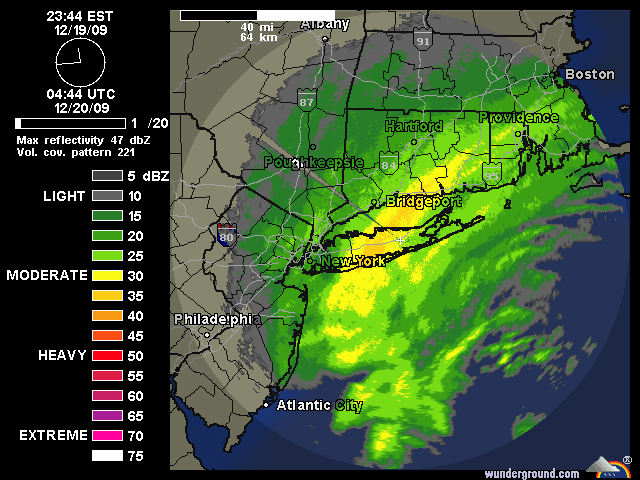
highlight of last winter for me...deformation band sets up over LI/SE CT for the Dec 20, 2009 storm...2-3"/hr rates: