

Sey-Mour Snow
-
Posts
4,048 -
Joined
-
Last visited
Content Type
Profiles
Blogs
Forums
American Weather
Media Demo
Store
Gallery
Posts posted by Sey-Mour Snow
-
-
1 minute ago, ORH_wxman said:
Sure...but you were on the line to begin with. Small changes in ejection of energy will lead to a noticeable sensible wx change. It could easily subtly shift back and then everyone will claim it was a massive model change.
If you are only looking through the lens of sensible wx, that’s true...and I guess most are. But from a modeling standpoint it isn’t a big shift. It’s why so many of is were saying how the solutions would probably be pretty volatile with just small changes.
Bottom line....keeping the southern energy very consolidated and robust is going to equal warmer solutions while shearing out just a bit could produce much colder solutions.
Theres also the timing of the first wave which effects the 2nd one and where the boundary sets up.
Yes, I guess that's why everyone is so dejected. The smallest shift upstairs causes a massive change in sensible weather for everyone up to CNE.. With the tenor of the season of getting burned, people just expect it to trend warmer. Still plenty of time left, lets see what today brings.
-
1 minute ago, CoastalWx said:
The 6z eps looked ok even for you to start.
Yes, it's much colder than the op, we hope.. If it's going to torch I'd rather have all sun and no rain.
-
59 minutes ago, ORH_wxman said:
Thread is totally irrational this morning. Modeling didn’t even change that much for this coming week unless you were buying the OP GFS yesterday that showed a lot of snow. Even then it’s a slight change in timing of energy ejection that could produce a lot more snow.
Half of these posts should just be flat out deleted. Making binary calls on an unstable setup at 4+ days out.
Lol EURO and GFS both changed quite a bit for us southeners. Instead of looking at several inches of snow sleet then freezing rain with a muted warm up. Now its maybe a coating of snow sleet Thursday AM while the rest of the week has highs of 50+ approaching 60 Thursday afternoon and Friday.
-
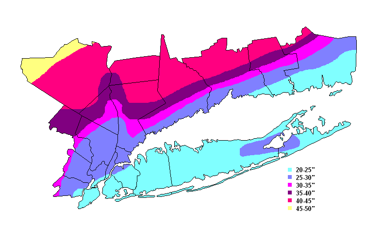
1 hour ago, tamarack said:
That's about the same snow as sites in the Jersey Highlands 25-50 miles west of NYC, but many of that area's residents work much closer to Gotham, so culturally the vibe is NYC/Jersey.
I live in this area and the weather is much different than the NYC metro,. The Danbury area averages much more snowfall that 25-50 miles West of NYC.. This is the map from NWS UPTON NY, seasonal snowfall average. You have to go well north and west of the city 75+ miles to get the same snow climo.
-
 1
1
-
-
4 minutes ago, Dr. Dews said:
you can't even get that correct.. ha
I think he meant the cold push is further south.
-
1
-
-
Classic - small flake and massive flake, thats how you knew the it was really going to snow. I was only 9 at the time.
-
Just now, Damage In Tolland said:
Seems to me it’s Sunday night and Monday
Saturday afternoon from earliest guidance through Sunday night on the later guidance
-
1
-
-
11 minutes ago, ORH_wxman said:
Well they had close to 2 feet on central/eastern Long Island IIRC. How far is that from northeast NJ?
@The 4 Seasons measured it out he has all the forecasts and totals saved. He says 90-100 mile error for 18”+. Orange County was forecast for 27-33” they got 1-3”. Our area was in the heart of the 27-33” forecast zone and ended up with 6-10”. For the 12”+ forecast, the error was around 135 miles.
-
 1
1
-
-
10 minutes ago, The 4 Seasons said:
 has commenced. Where is the obs thread
Light Rain - Unlimited Visibility - I have Mount Tolland as my landmark for visibility since I got scolded for my moderate snow report a few storms back. Even though it’s 50 miles to my NE, Mount Tolland is so high I’m pretty sure I can see it in the background. Or maybe that’s a tree. Anyways enjoy the rain it’s the only precip you got!
-
1
-
-
Oh it was much more that 20-40 miles lol forecasts were for 2-3’ west of NYC. It was more like 75-100 miles on the western edge.
-
8 minutes ago, CoastalWx said:
Where did I hate? I thought I was giving some love?
Just messing with your pull 5” out of our ass comment lol
-
Just now, CoastalWx said:
Yeah not mid level magic. But I can think of a few times where everyone is all about north and west but those spots just north of the Merrit pull 5”+ out of their ass.
Hey now don’t hate us southerners.
-
2
-
-
Looks like I ran the 3KM NAM from my basement. 7-8” over interior southern CT.
-
 2
2
-
 1
1
-
1
-
-
HREF loves western CT not so much Eastern CT. Kind of makes sense given temp spike. 2-4" for eastern SNE 4-6" west of 91 and the NE hills of CT and Worcester Hills up north and west.
-
30 minutes ago, weatherwiz said:
eliminating the cuteness beginning today!
When did you move to Milford? I'm actually aiming to move down there sometime in the spring. Can't wait...only a 20-minute commute to work as opposed to an hour
No! Less snow down there! Where do you work? Move to a southern CT hill-town!
-
Just now, ORH_wxman said:
GFS is really cold and basically turning into a miller B this run.
Yes, primary a good deal weaker this run.
-
GFS much slower like EURO for Saturday. Also pretty far south.
-
5 minutes ago, Ginx snewx said:
Asos are the worst though. I get your point but how many times do you see ASOS with light snow for 4 hours and then all of a sudden the observer is reporting 8 inches. I mapped out landmarks years ago. Cant tell you how many times I was 1/4 mile and area ASOS never fell under one half.
Exactly, I believe SOME of our obs are more accurate....
-
Storm total will be about .6" .. Not bad when you were expecting nothing.
-
1 minute ago, FXWX said:
Ok... small, localized enhanced areas; just a bit to your north OXC showing 10 mi. vis... hope you pick up a solid cover; sfc temps not helping out in many places... thanks for ob
I’m up at 550’ elevation it’s coming down good and sticking. Yes well it’s much lighter there as I’m between 20-25dbz and they are 10-15dbz. I’m in far SW Seymour.
-
1
-
-
7 minutes ago, FXWX said:
Is your actual ob or something that was passed along? I cannot find an airport visibility ob or a highway camera showing anything approaching moderate snowfall rates? I-84 / I-95 cams showing very decent visibility?
My observation it’s definitely steady light to moderate snow. Sticking to everything including roads. I’m about 6 miles SSE of OXC.
-
1
-
-
light to moderate 12 miles NW of New Haven coating so far .
-
Just now, USCAPEWEATHERAF said:
23z HRRR upped the snowfall amounts for CHH.
00z just came out even more than 23z..
-
1
-
-
3 minutes ago, Dr. Dews said:
I can't be the only one who is hoping DC/RIC hits 80+ in that torch
No I am rooting for it too, it’s going to torch might as well set records and enjoy on the weekend! Let’s get 3-6” first Tuesday night!
-
1
-
Feb To Forget? - 2020 Discussion
in New England
Posted
It definitely was more of a thread the needle solution down here. After the EURO tease for a few runs and especially on the 06z run showing a potent nor'easter earlier this winter ONLY 60-72 hours out only to completely take it away at 12z there on out, I'm not getting invested until like day 2 lol