

Sey-Mour Snow
-
Posts
4,048 -
Joined
-
Last visited
Content Type
Profiles
Blogs
Forums
American Weather
Media Demo
Store
Gallery
Posts posted by Sey-Mour Snow
-
-
Just now, RUNNAWAYICEBERG said:
Freezing snizzle would be nice to glaze over the pack for the week and the incoming Feb snow train.
Might go above freezing wednesday for a bit , then its cold, before the next "event(s)"
-
4 minutes ago, Spanks45 said:
What are we thinking around here? 1-3"? I worry it turns to sleet or freezing rain earlier than forecasted around here.....
I think we could see freezing snizzle after the initial thump which wouldn't hurt on accumulations .. seems like 1-3" is a good bet first thump here, then we will nowcast what happens after if anything.
-
Well that was fun while it lasted, my gut was correct. Congrats rt 2 north; hoping for an inch here. GEFS look awesome for CNE
-
 1
1
-
 1
1
-
-
1 minute ago, RUNNAWAYICEBERG said:
rgem is north too.
Trends continue to suck for us maybe an inch or two for us?
-
Just now, EastonSN+ said:
NAM went back to looking like garbage.
And well north again
-
13 minutes ago, dendrite said:
v16 with warning snows from ALB to the northern Berks. A few inches into S NH as well.
-
4 minutes ago, 78Blizzard said:
I think it was still going in places past 72 hrs.

-
 1
1
-
-
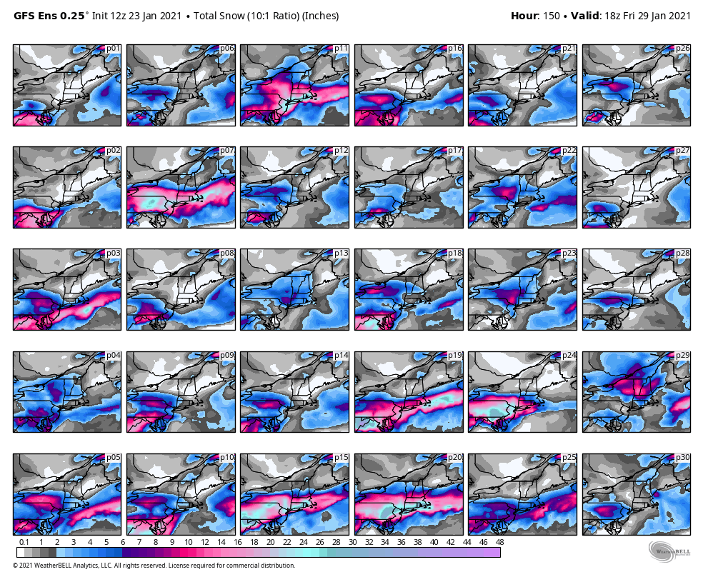
18z eps Another bump north and east with the goods, solid for most.

-
1
-
-
Just now, EastonSN+ said:
South Coast looks like has a bit extra. Moisture from the sound?
Things shift to south shore Wednesday early morning
-
1
-
-
Euro decent bump north with the goods into CNE. Not like GFS yet.
Also plenty cold except for maybe immediate south coast.

-
1
-
2
-
-
9 minutes ago, 78Blizzard said:
The Euro has not had those snows getting into CNE and NNE in any runs I have seen.
Inconsistent as in having a non event for several runs, now it’s 2-4”...
-
3 minutes ago, Damage In Tolland said:
You southern weenies do realize the FV3 you’re worried about is being retired on Feb1 right? The para takes over. Get off the pipe
Yes gfs is the farthest north and warmest but every piece of guidance is north another shift on those and it’s game over for us southern weenies. My gut tells me congrats Rt 2
-
6 minutes ago, 78Blizzard said:
The Euro said this is not happening. Typical 18z GFS run.
The euro has been just as inconsistent.
-
GEFS with a huge jump north. Not liking trends for southern areas.
-
1
-
 1
1
-
-
3 minutes ago, ORH_wxman said:
Not optimistic there or for Ginxy. Too far east. It’s possible that advisory snows happen that far northeast but we’d need to see something more like the Ukie or one of the JV models.
Like our area for some light snow, but could also see this just vaporizing.
-
Pretty big differences in Euro, that’s a much more favorable look for us for Thursday, keep it trending.
-
2
-
-
3 minutes ago, EastonSN+ said:
Thanks. I take this as 5 members skewing the mean north while majority are south and weaker.
Yes I looked closer at just Thursday I counted 6 big hits for SNE and 3 glancing blows, the rest well south.
So about 16% of gefs members would be in business.
-
1
-
-
8 minutes ago, EastonSN+ said:
Stole from MA forum.

New England just for Tuesday Thursday.
-
29th threat definitely on life support, verbatim Gfs is still very close and gives a few inches for the south coast . If other guidance jumps north I’ll stay interested if not congrats Mid - Atlantic.
-
1
-
-
47 minutes ago, CoastalWx said:
He’s not talking about next week.
Yes sorry, I’m not talking about next week.
-
1
-
-
2 minutes ago, WinterWolf said:
Ensembles ..EPS?
Looked great.
-
1
-
-
Kevin melts mean snow is coming! Keep it coming Kevin!
-
13 minutes ago, CoastalWx said:
What a melt by Kev. Yikes.
Beer.
-
3 minutes ago, CoastalWx said:
I mean last week for awhile we were like 34-35 for the high and 31 for the low I think for 2 or 3 days.
Same here only a few hours below 22 degrees this month. Low is 19.9.


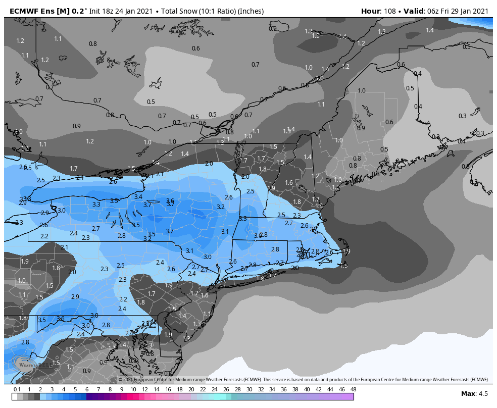
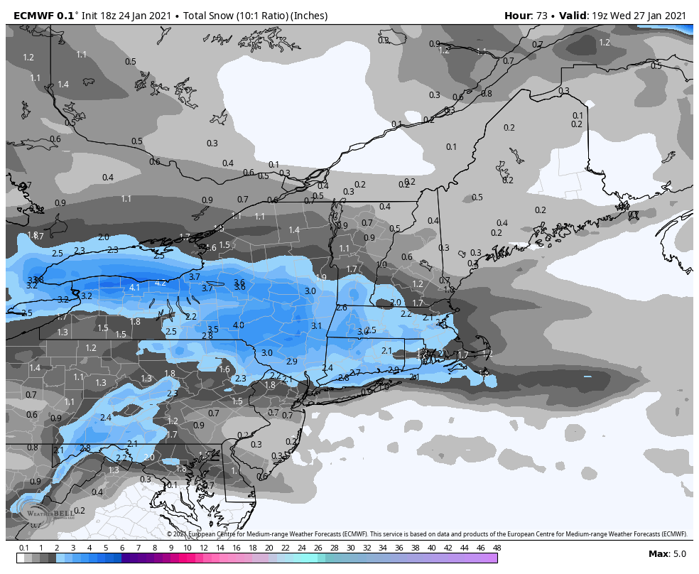

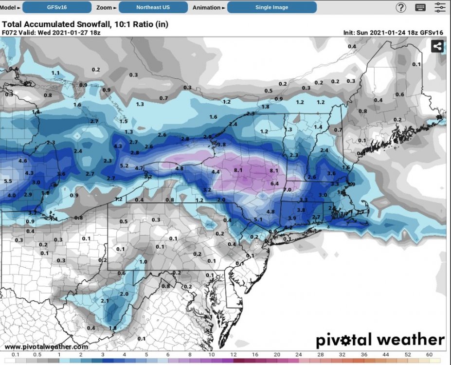
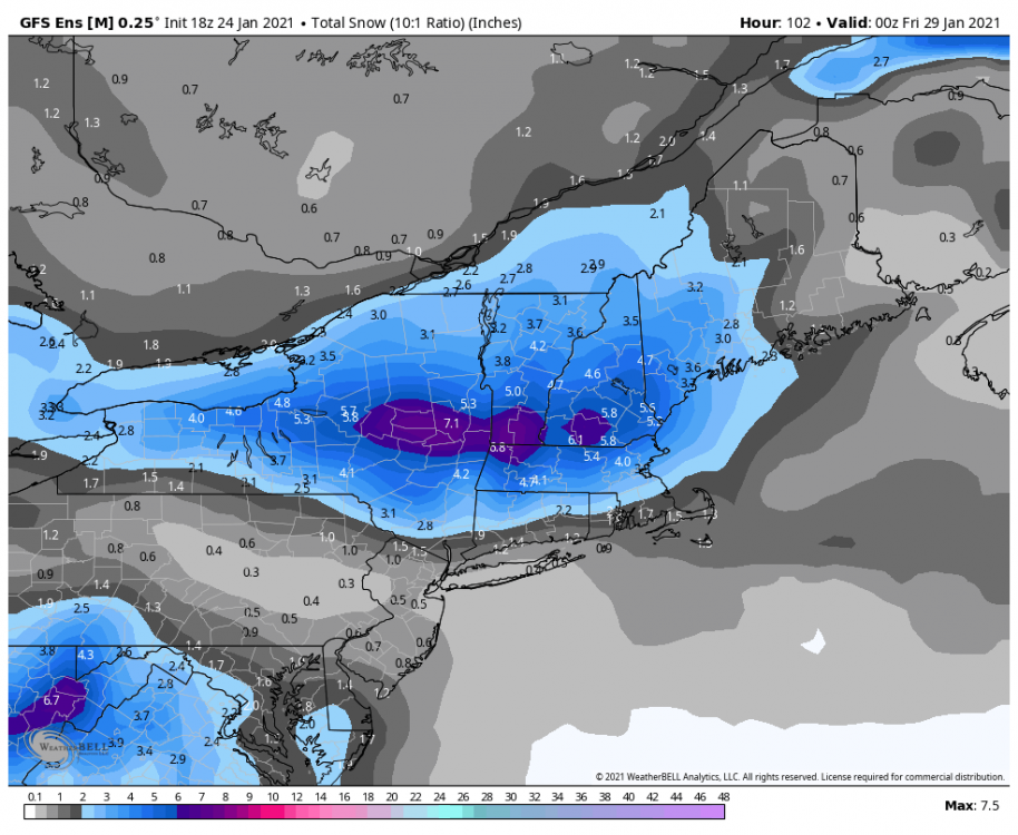
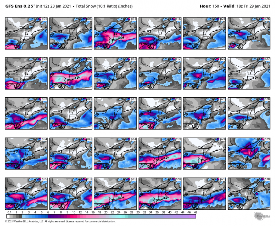
Jan 26-27 light snows
in New England
Posted
ran out of your basement!