

Sey-Mour Snow
-
Posts
6,919 -
Joined
-
Last visited
Content Type
Profiles
Blogs
Forums
American Weather
Media Demo
Store
Gallery
Posts posted by Sey-Mour Snow
-
-
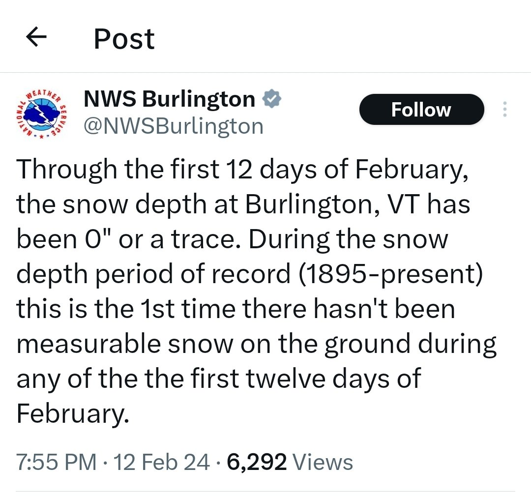
Grass is 100% covered for the first time since Jan 2022.
-
 2
2
-
-
2 minutes ago, CoastalWx said:
I think I’m too far north. This will be like more route 44 to south.
Hrrr has 4-6" after 8am for your area , lets hope thats right
-
1 minute ago, CoastalWx said:
Mix here. Skunked. Happy for you guys S and SW.
Thanks but I'm sure you'll get into some goods, need to spread the wealth on this positive bust
-
1 minute ago, TalcottWx said:
Loop OKX. I'm seeing signs of a significant band forming for the shoreline and E CT.
radar starting to light up for the whole state including the areas that got skunked so far
-
5" Warren , northern CT definitely cashing in, only coatings to 1" at the shore so far..
-
1
-
-
1 minute ago, TalcottWx said:
Jim Thorpe, PA has a report of 10.5" of snow and still falling. That's smack dab in the middle between Scranton and Allentown. Bodes well for many here.
Wow
-
Persistent fronto band just south of 84 wont quit
-
1
-
-
8 minutes ago, TalcottWx said:
YOU LOVE TO SEE IT.
Meteorology, not modelogy.
I sucked this storm I must admit, our bet is from late January on no snow over 3" anywhere in New England before Valentines Day.. He was 48 hours off..
-
4 minutes ago, TalcottWx said:
NYC weenies suicide watch, imo.
I'm watching Ch 3 cameras near the shoreline and there's not much happening down there. That's worrisome for south coastal areas.
BOS is going to get crushed. Whatever happened on models was wrong.
It's too warm in Mid-town urban heat effect.. best banding so far is just inland 2-4.5" widespread from merritt parkway to rt 84.. 4.5" new fairfield .. 8-11am should crush along shore ..
Also with several 3"+ reports I won the bet against @qg_omega
-
3
-
 1
1
-
-
1 minute ago, MJO812 said:
Enjoy
Congrats dude how you doing there
-
2 minutes ago, WinterWolf said:
Well Euro and HRRR and Ukie had very little to almost nothing here at 8 last evening, as we know.
Ya it’s pretty annoying , we know mid levels looked great but who honestly expected Southington to wake up at 5am to 1-2” per hour rates. We enjoy now take the L for the forecast and enjoy a snow day with the kids. Congrats @The 4 Seasons you the champ on this one
-
1
-
-
29.8 out heavy snow over an inch it seems edit 1.8”
-
1
-
-
Meso issued for shore 1-2+ for several hours
-
3
-
-
2 minutes ago, WinterWolf said:
Ya if I can shag me 4” tomorrow I’ll consider it a win. This morning I was in the 12-18” area on the NWS snowfall map. Infuriating.
Ya I feel the same
-
1
-
-
2 minutes ago, AstronomyEnjoyer said:
I wouldn't say amazing, I mean, it's only an inch... of snow.
Evidently that’s got nothing on Drake..
-
1 minute ago, CT Rain said:
GFS is south a bit but still good for the south coast. Seems like a bit of an outlier at the moment.
Ya that’s a major outlier 1-1.3” liquid south of 84. Cut back northern edge
-
-
3
-
1
-
 1
1
-
-
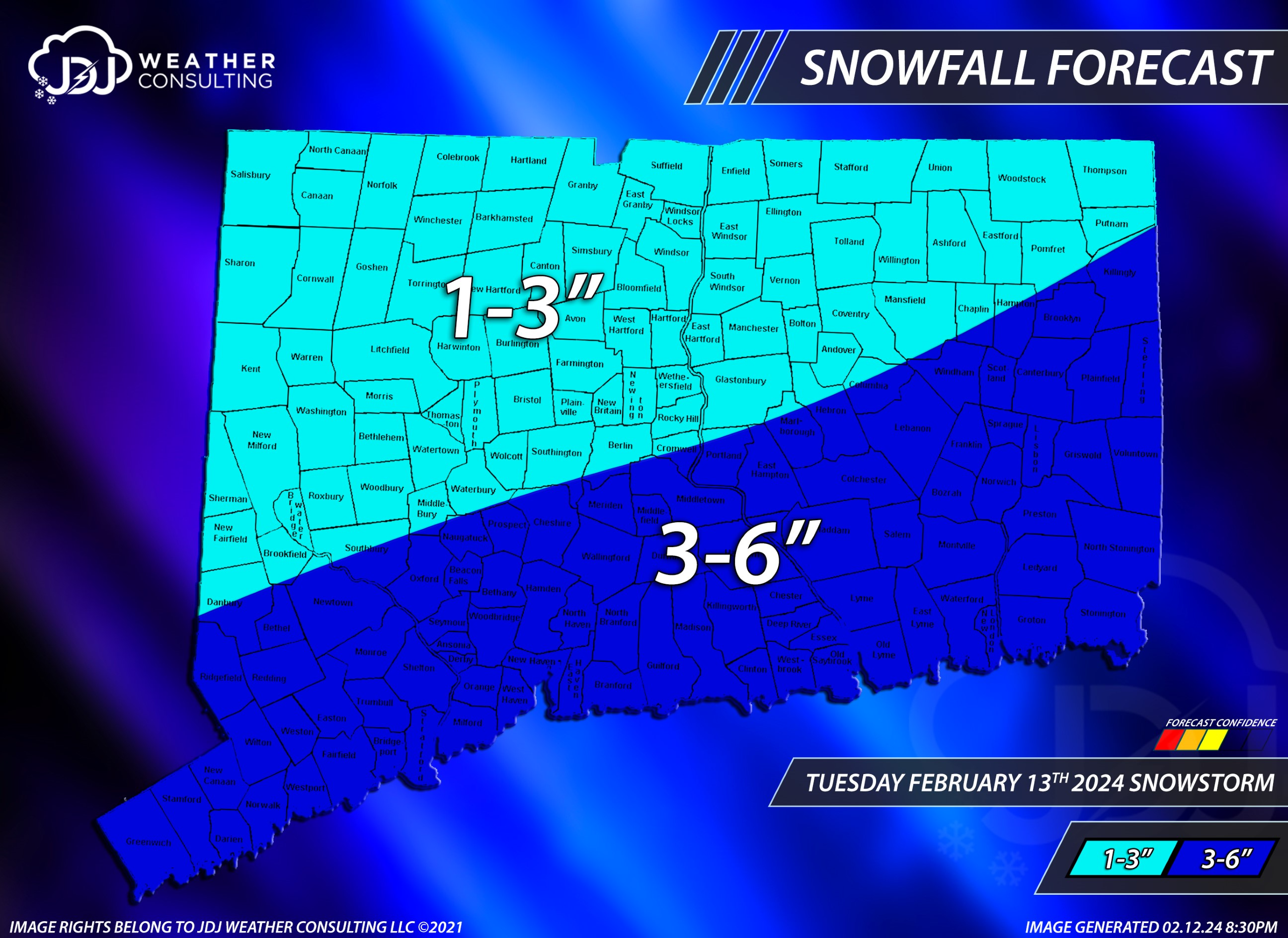
After an in depth discussion with @Torch Tiger @jbenedet and @qg_omega we decided to lower totals. "GIDDY UP"
*Disclaimer @The 4 Seasons does not approve of this map.

-
 1
1
-
5
-
 2
2
-
 1
1
-
-
1 minute ago, Hoth said:
With the way this is going, just get it the fuck out of here. My daffodils are 3 inches tall and my crocuses are in bloom. Bring on spring.
This reminds me a little of that March '18 storm that was supposed to dump on southern CT, but wound up with a sandy inch while Long Island cleaned up 2 feet.
has anyone else seen a bunch of large flys the past two days? I've had three in two different indoor locations? The low 60s Saturday woke them up?
-
2
-
1
-
-
Parts of CT and Mass were well within the 12-18" cone at 18 hours out to potentially see zero inches of snow. @ORH_wxman how many times has that happened this close in?
-
3
-
1
-
-
3 minutes ago, jbenedet said:


Best part is I may owe @qg_omega $25 while he's sitting there smiling when no one sees 3" tomorrow
-
1
-
2
-
-
6 minutes ago, CT Rain said:
Yup... HRRR looks worse. Blahh.
The rug has been pulled out for most!
-
22 minutes ago, 40/70 Benchmark said:
I am so worn out and defeated....so sick of it all. Gonna have to think long and hard about whether I even want to do this next year.
Been thinking the same thing all day
-
1 minute ago, MJO812 said:
My first winter storm warning since 2022.
4-8 inches
Really hope you do well
-
1
-
Following a Miller A/B hybrid type coastal potential, Feb 13th ... As yet untapped potential and a higher ceiling with this one
in New England
Posted
4.0" 29.5 . pounding out