

Sey-Mour Snow
-
Posts
4,048 -
Joined
-
Last visited
Content Type
Profiles
Blogs
Forums
American Weather
Media Demo
Store
Gallery
Posts posted by Sey-Mour Snow
-
-
1 minute ago, powderfreak said:
Average high at BDL has been 40F. Normal 34F for +6 on highs since the New Year, it's odd it feels seasonably cold to you guys compared to the averages.
6 days so far in January have hit or exceeded 40 degrees? Maybe it's been dry with lower wet-bulbs?
I’m in southern CT but it’s much colder here than BDL highest temp is 36.9 since Jan 2nd.
-
1 minute ago, powderfreak said:
Yeah definitely the overnight lows, but it's still an average high of 36F at 1,000ft in ORH. Normal is 31F. That's +5 on highs at 1,000ft.
Ya just looked +4.2 at orh this month on highs +8.5 on lows.
-
 1
1
-
-
3 minutes ago, powderfreak said:
Huh, seasonably cold!? Or just near freezing enough to keep frozen?
ORH’s last below normal day was on December 19th. BDL on the 20th and BOS on the 21st.
We are going on several weeks without a daily departure below normal. That’s incredibly warm.
ORH... +6.4
BDL... +6.3
BOS... +4.2
Seems to me like its been more overnight lows making the daily departures look so warm, highs haven’t been too bad, it’s mostly felt like winter besides the Christmas torch.
-
Just now, Damage In Tolland said:
Which is interior . That’s the only point. ETAN making it seem like there’s sand
No you are about as inland as can be in CT. I’m inland SWCT but only 12 miles on a straight line.
-
54 minutes ago, Damage In Tolland said:
Are you drunk? 20-30 miles

Ya probably 1 beer its about 35-40 miles on a straight line from Northern Tolland.
-
Just now, CoastalWx said:
People getting quite ridiculous over a week where nothing was progged to happen. Classic. Go hug your loved ones and come back next weekend.
Ya everything is right on track lol. Today was always a bonus, sucks that it will miss, next weekend is still a long ways away so let’s see how that trends. Besides the really favorable pattern has been looking like it will set up post Jan 10 for a while now. .
-
Just now, dryslot said:

That’s fantastic.
-
Just now, Spanks45 said:
The Herps actually showed this too at 18z, odd for that model as it usually has a monsoon for every system....we shall see, could be a blip and all is well by 6z tomorrow
Ya I saw that, concerning.
-
1 minute ago, powderfreak said:
You guys really haven’t been paying attention to the Euro have you? I’m not saying it’s right or wrong, but these posts make me think no one had seen it’s bias before of being NW of other guidance.
It's been much better this year with that, as Ray said it wasn't nearly far enough NW with 12/17.
-
Just now, ORH_wxman said:
Yeah those are some UGLY runs. Really bizarre seeing this so close to the event when you have the euro much better looking.
It’s weird that the midlevel stuff is actually pretty potent out to the west in NY state and then just goes poof as it enters SNE.
Yes, I've learned never to discount anything, let alone pieces of guidance, keep an open mind, there's definitely plenty of signs of a shredded mess. Glad Euro and EPS is on our side, we will see.
-
Just now, Damage In Tolland said:
Who cares
You will when you wake up Monday to a green lawn.
-
1
-
 3
3
-
 1
1
-
-
3km NAM, 12km NAM, HRRR, 0 for 3 at 00z all shredded POS
-
What the hell happend to the NAM?? Atrocious!
-
First 00z run of the night didn't start off too well. Long range HRRR looks just like the NAM.
-
Only 4-4.5 days from go time on various guidance Tip. So definitely not too early. Let’s see how it trends, looks a lot better for your area than mine but I’m interested.
-
4 minutes ago, Typhoon Tip said:
thanks Dude -
Yeah.. . I wanted see this before making this point. It's not exactly salient/novel or anything buuuut,.. the GFS solutions as of late simply do not fit that signal - not from the EPS, nor its own GEFs' -derivatives regarding the NAO domain.
I don't even think the Euro operational run does very well either frankly - that 12z solution was a joke. Actually worse than the GFS on that one run.
I'm talking about the D5 - 12 range. Something's not right - doesn't add up. tryin' to figure the f'er out

-
2
-
 1
1
-
-
2 hours ago, Damage In Tolland said:
I hope so but man , 2 days of 50+ is gonna be brutal if it happens like he’s got .We’d be looking green grass and a couple driveway snowbanks. I still think this gets shunted to a degree . Many times they do.
Just dug into it a bit. Obviously this will change but today’s trends are for a 12-18 hour torch. Latest GFS is about 1pm Christmas Eve to 4am Christmas Day with temps above 50. Maxing out at 63 on Christmas at midnight. So not as bad as it seems duration wise, but it does seem pretty warm for a bit.
-
RGEM looks fun, make that another model not agreeing with the GFS. I expect a massive GFS cave right now with new data.
-
1
-
-
Just now, JoeSnowBOS said:
EURO has trended south and East....NAM past 60 is useless
EPS hasn’t budged. If GFS holds and Euro goes south , all hail GFS.
-
1 minute ago, JoeSnowBOS said:
Looks like support growing for GfS - even it ICON. Looks similar for sure and southeast trend continues. “King” GFS
Yes exactly because NAM and EUro looked just like that too
-
1
-
-
4 minutes ago, RUNNAWAYICEBERG said:
It says 5”+, no?
-
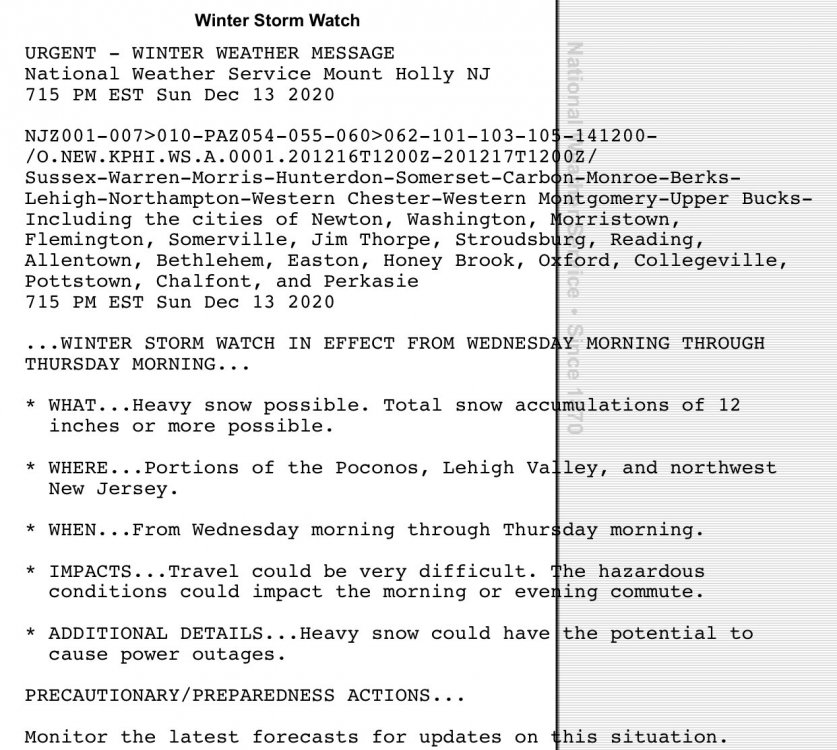
Watches up for 12”+ Mount Holly!
-
1
-
-
6 minutes ago, Spanks45 said:
hopefully all of us have a ton of snow....I think my largest storm since moving here in 2014 has been 18 inches.....
Since Nemo, largest here is 15” rough stretch for the big ones esp. since March 2018.
-
37 minutes ago, RUNNAWAYICEBERG said:
You’ll see a lot of snow.
Lol you are not too far from me.
January 2021
in New England
Posted
It can be much worse we were 74 on this day last year and had several days in 50s and 60s those years. Last 9 days have been below 37 here which is not horrible for southern CT.