

wxsniss
-
Posts
5,812 -
Joined
-
Last visited
Content Type
Profiles
Blogs
Forums
American Weather
Media Demo
Store
Gallery
Everything posted by wxsniss
-
Was wondering why no comments... 0z Euro with a nice looking northern stream system next Friday GFS and GEFS/EPS have it too Actually something to track.
-
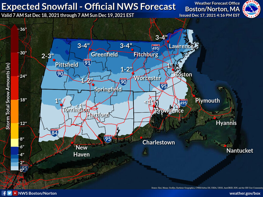
Congrats VT/NH folks... otherwise, yeah really annoying system, can't think of a single redeeming feature. Red flags all over (high DGZ, junk antecedent, meager qpf, etc we all posted yesterday), but the cooling trend Thursday had me thinking at least advisory in much of Mass. Has the RGEM ever been this bad? Probably, just can't remember a recent fail as bad as this. Up to 18z last night (24 hours before event) it was consistently showing warning level snows through a big chunk of MA.
-
Looks about right. Canadian models (including 18z RGEM) stubbornly aggressive and on their own.
-
Agree Antecedent mass is junk, there's no robust confluence to anticipate trends the other way, ratios will be crap with DGZ much higher than best lift, meager QPF, and boundary layer will be working against us in the coastal plain. Box will probably shave map an inch or so across the board in afternoon update
-
12z RGEM isn't budging much, still the coldest On its own here
-
0z Euro ticked a bit warmer looking like low end advisory south of pike high end advisory north of pike warning closer to VT/NH border Box this morning:
-
A meager event, but pretty decent consensus at 48 hours. How could this surprise other than colder/warmer? Other thing I'm watching is if QPF ramps up or shreds out. 12z -> 18z looked a tick drier. We don't have much buffer...
-
I think you're good for 3-4" given the tics colder at 12z today. Just outside of Boston metro inside 128 I'm thinking 1-3". Not bad model consensus 48 hours away. At the moment, NAM seems on its own with the aggressive WAA. 18z RGEM ticked warmer, but it was one of the coldest models so far.
-
Box early forecast is most similar to 12z GFS If this remains colder like 12z Euro/RGEM, would add 1-2" in most areas
-
Wednesday 12/8 Possible Snow/Ice/Rain? Discussion
wxsniss replied to Torch Tiger's topic in New England
0z HRRR had literally 0 through midnight for our eastern areas… I was worried we might actually go for broke so glad we at least whitened -
Wednesday 12/8 Possible Snow/Ice/Rain? Discussion
wxsniss replied to Torch Tiger's topic in New England
Looking good for c-1 0z HRRR fail -
Wednesday 12/8 Possible Snow/Ice/Rain? Discussion
wxsniss replied to Torch Tiger's topic in New England
30F now near Coolidge Corner We were 34F at 8pm -
Wednesday 12/8 Possible Snow/Ice/Rain? Discussion
wxsniss replied to Torch Tiger's topic in New England
Hard to discern best LL convergence, winds with an easterly component all the way to Worcester Hopefully HRRR fades too quickly as returns move east and we at least whiten CF below just as you saw on radar... we dropped from 34 to 31 in past 30 min:
-
Wednesday 12/8 Possible Snow/Ice/Rain? Discussion
wxsniss replied to Torch Tiger's topic in New England
Great to hear you're back, Jerry!!! The news had me nervous about MI/stroke. Look how fond this community is of you! -
Wednesday 12/8 Possible Snow/Ice/Rain? Discussion
wxsniss replied to Torch Tiger's topic in New England
Thanks for the update. Your weather family is concerned and thinking about you, Jerry. Hope it was just a scare and you’re back home soon. -
December 2021 Obs/Disco...Dreaming of a White-Weenie Xmas
wxsniss replied to 40/70 Benchmark's topic in New England
Belated happy birthday Jerry! Congrats on making it to halftime This Wed event on GFS has a 1993-94 feel to it -
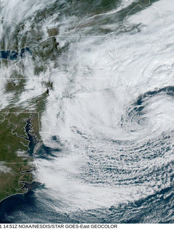
Neat cloud pattern in wake of the departing low… almost resembles the water pattern in wake of a receding wave at the beach
-
The animated satellite images are nicer, not enough space to upload... GOES-16 loop
-
Also, how is Nantucket with 0% power out Must be an error
-
Really is an impressive cutoff I posted earlier, trying to piece together — between LLJ max, radar returns allowing mixing down, and elevation — why there isn’t more of a gradient. You have counties with 99% out adjacent to counties with 5% or less
-
489,849 without power Really remarkable cutoff to areas that experienced strongest winds, using power outages as proxy Nice overlap of max LLJ (80-90kts at 850-950 mb) with precip echoes
-
Eversource 118k, if continues at this rate may top 200k by sunrise Like a giant Doppler couplet:
-
Eversource EMA outages 105,050 Literally increases several thousand every 10 minutes
-
Eversource EMA outages 95,526 Was 27k at 1:30a
-
Eversource EMA outages big jump since 2am, now 87,679, 7% customers Center just east of ACK


