HinghamBoss
-
Posts
383 -
Joined
Content Type
Profiles
Blogs
Forums
American Weather
Media Demo
Store
Gallery
Everything posted by HinghamBoss
-
“Cory’s in NYC! Let’s HECS!” Feb. 22-24 Disco
HinghamBoss replied to TheSnowman's topic in New England
Long time lurker, occasional poster. These numbers and dynamics look special. Bullseye for a 30 burger looks somewhere between that SE MA circle of rte 95 on the west to route 3 on the east and 44 along the south. Towns like Foxboro, Hanover, Carver and Brockton. I get the sense I may be just north and “only” get 15-20.” Talk about first world probs. -
“Cory’s in LA! Let’s MECS!” Jan. 24-26 Disco
HinghamBoss replied to TheSnowman's topic in New England
Anyone else with nervous energy based on: - remarkable alignment / continuity over last 4 to 5 days - positive trends as we get closer -
That was an insane storm here. Some of the most vivid cloud to ground lightning in awhile with quarter sized hail. Thunderstorm of yore.
-
Significant Miller B Nor'easter watch, Apr 3rd-4th
HinghamBoss replied to Typhoon Tip's topic in New England
Was not banking on this one to work out given the situationals/time of year, but the last couple of days evolution is completely on script with last two years around these parts. -
It is comical how similar all of these are. Rains for hours, we get our ceremonial 1-2" on the way out.
-
Flipped over to almost all snow now. Let's see what we can do in next 3-4 hours. 2" of paste would be a win.
-
Looking at temps, anyone to the south and west of route 3 is snowing. Seems like the R/S line is slowly working east from Rt 24 to Rt 3.
-
Snowing in seemingly every other direction except here. Can't have nice things.
-
Heavy rain here. Love that it is snowing on the Cape though.
-
At this stage, how much of a shift can we expect? Realize the ridiculousness of the question given how today played out.
-
One burp north and this can be a face saving ~6 inch storm for BOS to HFD south and east.
-
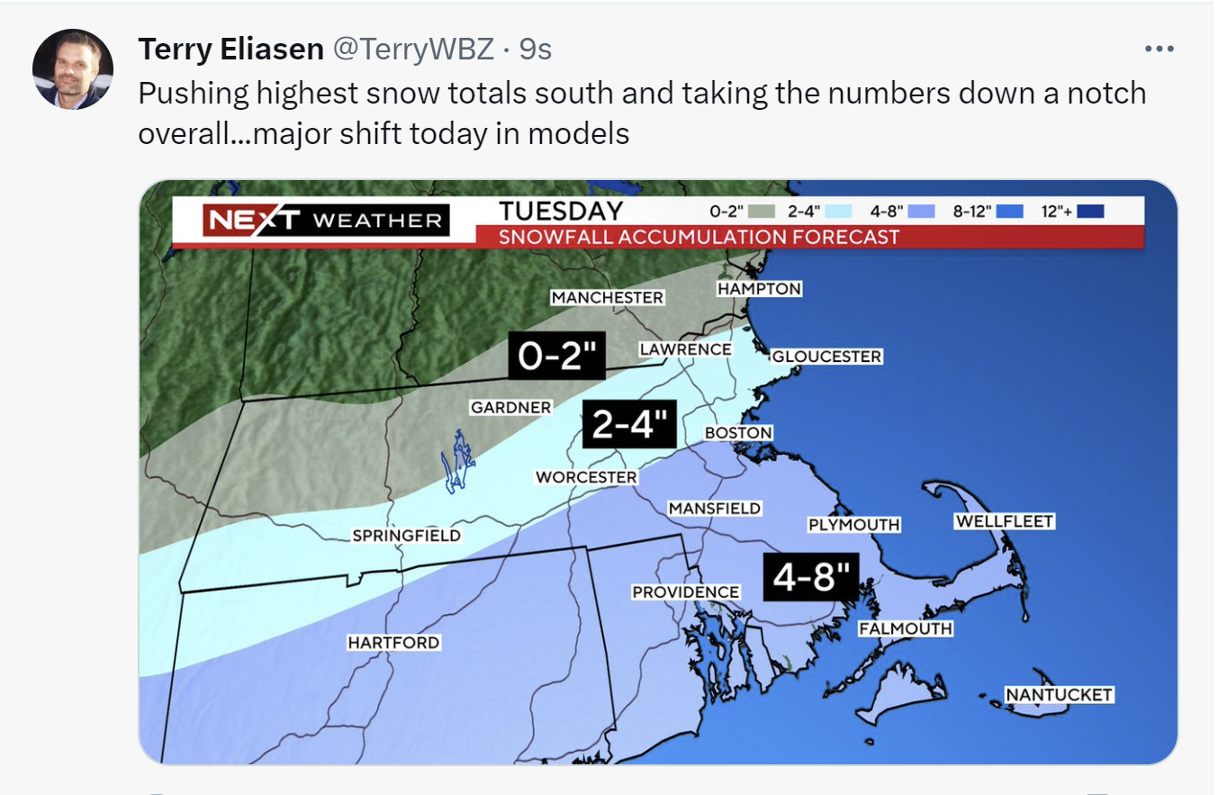
From BOX: .NEAR TERM /THROUGH TUESDAY/... Key Points... * Quick hitting Winter Storm Tuesday, though the trend has been less snow and quite a bit further south. * Generally thinking the bullseye will be over southeast MA/southern RI where 6-10 inches is possible. * Dangerous travel possible with widespread 1-2" per hour snowfall rates possible Tue AM through the afternoon. May even have brief instances of 3" per hour rates. * Wet snow & strong winds along the coast may result in power outages.
-
Your 4-7 prediction here may all work out...albeit not how we envisioned it.
-
Indeed. Hence why I was scratching my head that warnings in place in the spots they were, plus adding further S and E. Feels marginal if criteria will even be met there.
-
Am I seeing things right - did BOX expand Winter Storm Warnings to the coast?
-
Total debacle. Ironically, down these parts the temperatures look better.
-
The 3K map looks nice, but I don't see a world where SE MA is putting down 10:1 ratios.
-
What's fascinating here: the models have largely been consistent for days on end.
-
Have looked at those throughout the winter and every storm has been way overdone.
-
Feels like the goalposts are narrowing and we are getting to some level of consensus. There's going to be a 4-6 hour window tomorrow that is going to be fun - for many of us, the most fun we have seen in a couple years.
-
Could see a scenario where you are closer to 8 and I am closer to 5-6.
-
I dunno what the exact totals will look like around here, but if the Euro verified it would be a fun few hours.
-
Story of the last two years. Remember the same sentiment last storm.
-
I am not asking for much - 6 would be fine. 4 would be a disappointment.