SACRUS
-
Posts
15,490 -
Joined
-
Last visited
Content Type
Profiles
Blogs
Forums
American Weather
Media Demo
Store
Gallery
Everything posted by SACRUS
-
2002 was hotter than 1983 for the areas despite not reaching 100. Plenty of 97,98, 99's for the city and elsewhere. A degree.
-
We'll see if something deepens underneath the building ridge in the weakness offshore
-
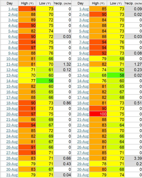
Aug max temps EWR back to 2010 2024: 100 (8/1) 2023: 91 (8/21) 2022: 101 (8/9) 2021: 99 (8/13) 2020: 94 (8/10) 2019: 94 (8/19) 2018: 96 (8/28, 8/29) 2017: 93 (8/1) 2016: 98 (8/13) 2015: 97 (8/17) 2014: 93 (8/27) 2013: 91 (8/21) 2012: 95 (8/5) 2011: 98 (8/1) 2010: 98 (8/31)
-
Records: Highs: EWR: 100 (2006) NYC: 100 (1955) LGA: 102 (2006) JFK: 98 (1975) Lows: EWR: 53 (1940) NYC: 57 (1875) LGA: 59 (1953) JFK: 59 (1985) Historical: 1944: A hurricane formed in the Bahamas and came ashore at the North Carolina/South Carolina border. It moved north as a tropical storm, then curved to the northeast, passing across the lower Delaware Bay on its way out to sea. Philadelphia, PA received 2.39 inches of rain and 0.22 inches on the 3rd. This was the first of three tropical systems to affect the Mid Atlantic states in 1944. (Ref. Wilson Wx. History) 1945: Washington, DC had 3.39 inches rain in 3 hours, 4.26 inches in 6 hours and 5.18 inches in 12 hours. (Ref. Washington Weather Records - KDCA) 1954 - Severe thunderstorms produced golf ball size hail for thirty minutes in north central Kansas. One drift measured 200 feet long, seventy feet wide and three feet deep. (The Weather Channel) 1964: Muskegon, Michigan records its hottest day ever with a reading of 99 °F. (Ref. WxDoctor) 1970: At least eight people drowned on Florida Panhandle beaches due to the effects of Hurricane Celia which passed hundreds of miles to the south and made landfall near Corpus Christi, TX. Rip tides and heavy surf with waves up to 10 feet pounded the beaches of Escambia, Okaloosa and Santa Rosa Counties. The Escambia County Sheriff reported 25-30 emergency calls with lifeguards rescuing at least 12 people. (Ref. Wilson Wx. History) 1974: 25 miles east of Buffalo, Wyo.--Lightning struck a party of fishermen, killing one and injuring four others. (Ref. Lightning-The Underrated Killer.pdf) 1975 - Record heat gripped New England. Highs of 104 degrees at Providence, RI, and 107 degrees at Chester and New Bedford, MA, established state records. The heat along the coast of Maine was unprecedented, with afternoon highs of 101 degrees at Bar Harbor and 104 degrees at Jonesboro. (The Weather Channel) Boston, Massachusetts had a 102 °F temperature the warmest temperature for August. (Ref. NOAA Boston Weather Events) 1978: Very heavy rains of 12 to 14 inches fell across the Texas Hill Country during the nighttime and early morning hours causing severe flooding on the Guadalupe River. Up to 30 inches of rain fell during the 3-day period from the 1st through the 3rd. 27 people died in the Hill Country flooding along with tens of millions of dollars in damage. More flooding occurred during the early evening near Abilene, where six people were killed. (Ref. Wilson Wx. History) 1980: The intense heat wave continued in Texas. Dallas had their 41st consecutive day of 100° readings. The streak eventually reached 42 days. Abilene, TX was on their 41st consecutive day of 98° or higher, tying a record that dated back to 1952. El Paso, TX was on their 51st consecutive day of 100°+ temperatures. Other record highs included: Oklahoma City, OK: 110°, Tulsa, OK: 108° and Springfield, MO: 102°. (Ref. Wilson Wx. History) 1985: A strong and sudden wind gusts cause a plane crash at the Dallas/Fort Worth Airport in Texas that kills 135 people. The rapid and unexpected formation of a supercell, an incredibly powerful form of a thunderstorm, led to the tragedy. 1987 - Hot weather continued in the central U.S. Fifteen cities reported record high temperatures for the date, including Concordia KS with a reading of 106 degrees, and Downtown Kansas City, MO, with a high of 105 degrees. Evening thunderstorms produced severe weather in the Ohio Valley and the north central U.S. Thunder- storms in South Dakota produced wind gusts to 70 mph at Philip, and hail two inches in diameter at Faulkton. (Storm Data) (The National Weather Summary) 1988 - Searing heat continued from the Middle and Upper Mississippi Valley to the Middle and Northern Atlantic Coast States. Twenty- six cities reported record high temperatures for the date. Chicago IL reported a record seven days of 100 degree heat for the year. (The National Weather Summary) 1989 - Low pressure representing the remains of Hurricane Chantal deluged north central Texas with heavy rain. Up to 6.50 inches drenched Stephens County, and Wichita Falls reported 2.22 inches of rain in just one hour. Bismarck, ND, reported a record warm morning low of 75 degrees, and record hot afternoon high of 101 degrees, and evening thunderstorms in North Dakota produced wind gusts to 78 mph at Lakota. Early evening thunderstorms in Florida produced high winds which downed trees at Christmas. (Storm Data) (The National Weather Summary) 1995: Hurricane Erin made landfall near Sebastian Inlet in southern Brevard County during the early morning hours. Brevard County bore the brunt of the storm with wind gusts to 100 mph between Melbourne Beach and Cocoa Beach knocking down trees on houses, cars, and power lines. As Erin moved through Orlando during the morning wind gusts to 60 mph downed trees on power lines, houses and cars. About one-half million people were without power initially, several thousand were without power for more than five days. Heavy rains of up to 8 inches in three hours on the backside of Erin hit Brevard County again during the afternoon causing widespread flooding of low lying areas. Erin moved into the Gulf of Mexico during the afternoon as a tropical storm, but regained hurricane strength. Erin then made a second Florida landfall near Pensacola on the morning of the 4th with sustained winds of 95 mph gusting to 110 mph. Damage in the Pensacola area was estimated at $300 million dollars. (Ref. Wilson Wx. History) 1996: Powerful thunderstorms moved across southwest and south central Kansas during the evening hours. In Pratt county eight train cars were blown off the tracks while the train was moving. This occurred one mile west of Cullison. One family was nearly run over by the derailing train cars. One boxcar ended up about 10 feet away from their vehicle. From three miles south of Lewis to Belpre, very strong thunderstorm winds killed calves, blew cars off the highway and blew down 60 power poles. There were unofficial and unconfirmed reports of 125 mph winds recorded on home stations (Ref. Wilson Wx. History) 2000: Massive downburst winds estimated at 90 to 110 mph hit areas from eight miles west of Spearfish, SD to several miles east of Spearfish. Hail, to golf ball size accompanied the high winds and damaged roofs and siding throughout the region, although the winds caused the worst damage. The airport at Spearfish had 27 planes damaged, and seven of those were destroyed beyond repair. Seven hangers at the airport were also damaged or destroyed. Roofing material sliced through an oxygen valve at the Spearfish Trout Farm and killed 100,000 out of 120,000 trout that the family raised. In the Spearfish city campground, more than 150 campers were there, in anticipation of the 60th Annual Sturgis Motorcycle Rally the following week. None of the trees fell on occupied tents, although several fell within inches of where people were sleeping in their tents. In Rapid City, the National Weather Service office measured wind gusts of 70 mph. The storm weakened as it moved southeast of Rapid City, but was still at severe limits as it passed over the Badlands National Park and went southward into Bennett County. Observers in Martin reported 60 mph wind gusts. (Ref. Wilson Wx. History) 2001: Chicago Illinois was pounded by up to 3.50 inches of rain in one hour in the a.m. rush; some interstate expressways were under 8 feet deep water. Some 228 stalled vehicles had to be towed. 10,000 homes had water damage; 50,000 customers without power at the peak of the storm. (Weather Guide Calendar with Phenomenal Weather Events 2007 Accord Publishing, USA) (Ref. WxDoctor) 2008: Denver, Colorado: A 130-year-old high-temperature record falls in Denver, when the mercury hit 103 °F. (Ref. WxDoctor)
-
67 / 59 . Clear and gorgeous out. Low - mid 80s today. Same maybe a touch warmer tomorrow. Mid - upper 80s Monday, perhaps 90 in the hot areas inland NJ. Overall near normal the next week with a onshore barrage. Wed/THu still watch if rain make it north of DE/NJ but lookig dry. Atlantic ridge hovering off the east coast, ridge back west and northeast. Flow comes around by next weekend with a warm - hot / humid wet overall into the beyond.
-
1953 sure had its period of strong heat and the record late Aug/early sep heat but there were in some cases 2 week period of cooler too imbedded. 33 90 degress days at EWR and 12 at JFK.
-
I wish the dataset included Dew ppoint temps
-
Clouds moving NE--> SW into CT, E-LI clearing on the ENE flow, clouds from the boundary moving W - E in Southern sections.
-
Wed / THu watch if any of the rain can get north of SNJ.
-
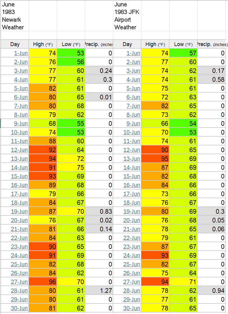
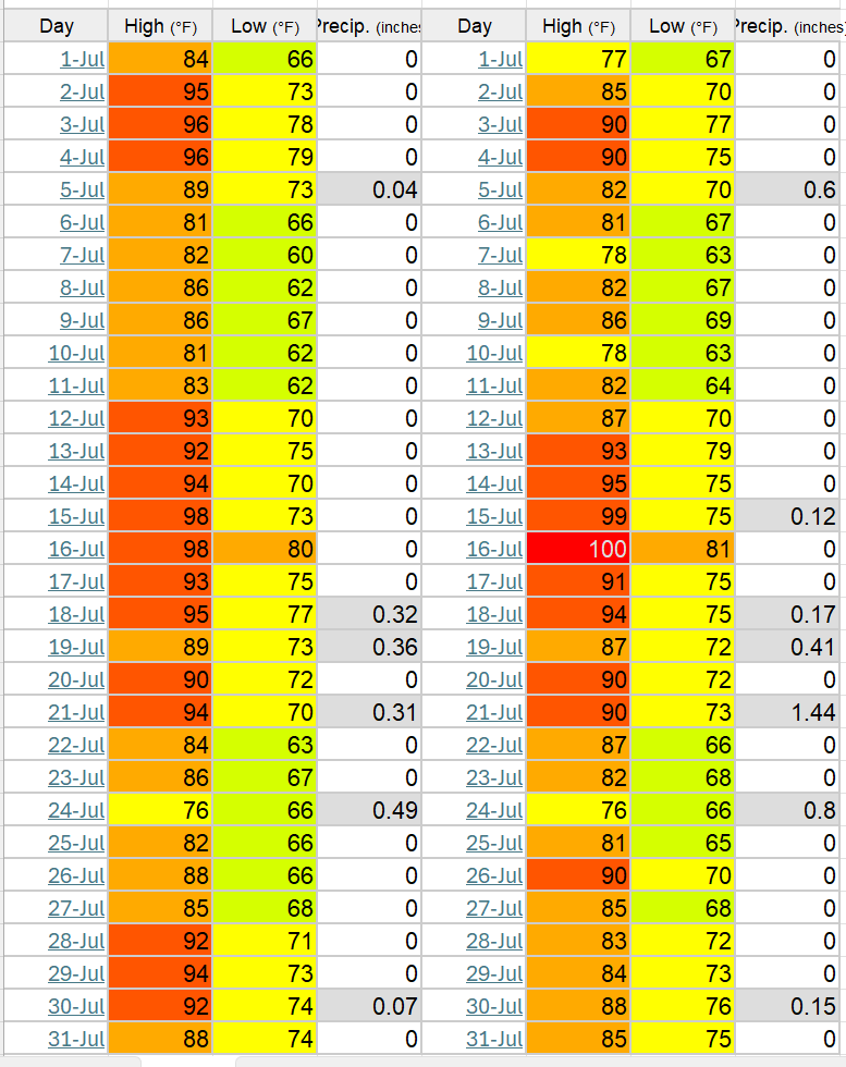
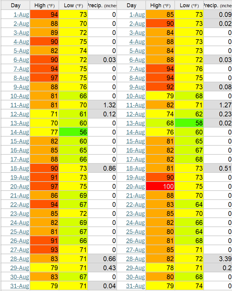
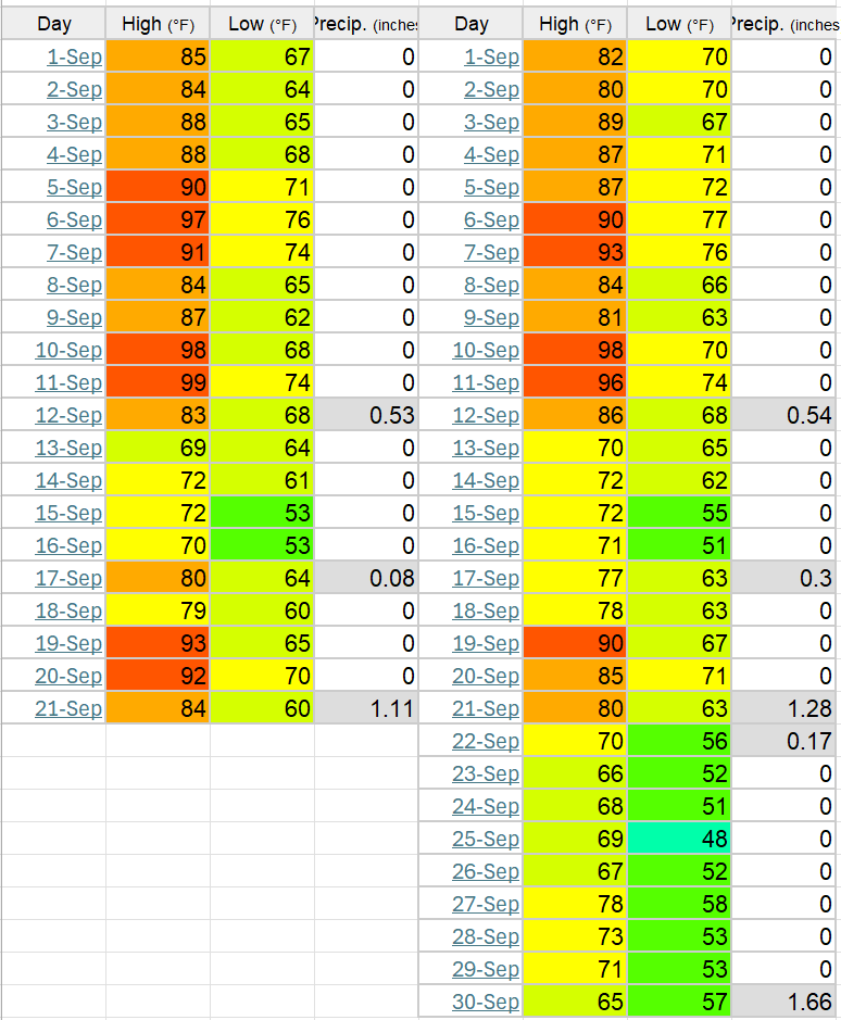
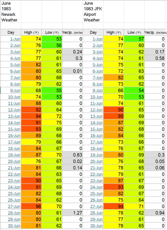
Side by side EWR overall hotter, JFK had higher max


-
EWR Max 1983 June: 96 July: 98 Aug: 97 Sep: 99
-
2010 was overall sustained heat but June max was only 98 / Jul - 103 / Aug - 98 Not sure but think the list is summers with 2 or more months with 100 degree or higher readings.
-
Happened in June 7/27 after 100 degree heat (48 hours) same this time. The weekend look fantstic cooler at the beaches with this onshore barrage.
-
Have you been able to play with the EC AI ensembles, yet? I am seeing they are outperforming all other ensmbles.
-
July 2025 Discussion-OBS - seasonable summer variability
SACRUS replied to wdrag's topic in New York City Metro
EWR: +3.9 (82.1) Rain: 4.04 4 days below normal , 1 at normal, 20 90 degree days Mac 101 / min 65 -
Records: Highs: EWR: 100 (2006 / 2024) NYC: 100 (1933) LGA: 100 (2006) JFK: 97 (2006) Lows: EWR: 52 (1943) NYC: 59 (1964) LGA: 62 (1947) JFK: 60 (1964) Historical: 1812: A tornado struck parts of Westchester County, New York. The same storm today would have caused major destruction. (Ref. AccWeather Weather History) 1917: 80 forest fires ,were ignited in Trinity County, California when an electrical storm produced hundreds of lightning bolts over a small area which was tinder-box dry from severe drought. (Ref. AccWeather Weather History) 1947: What turned out to be the hottest August on record started off on a decidedly cool note across parts of Michigan with record lows at: Houghton Lake, MI: 32°, Ste. St. Marie, MI: 36°, Muskegon, MI: 43°, Flint, MI: 43° and Grand Rapids, MI: 48 °F. (Ref. Wilson Wx. History) 1954 - Mount Rainier in Washington State was still covered with sixteen inches of snow at the 5500 foot level following a big snow season. (David Ludlum) 1966: Very strong winds from severe thunderstorms struck northwest Oklahoma. Winds gusted to 80 mph in Laverne, and blew a parked Cessna aircraft through a fence and into a ditch. As the storms approached Gage, winds gusted to 92 mph, causing blowing dust that reduced the visibility to near zero. (Ref. Wilson Wx. History) 1972: This was the first of 25 straight days without measurable rain at Philadelphia, PA. (Ref. AccWeather Weather History) 1974: Georgia--An 18-year-old youth was killed by lightning at a lumber camp on the Ocmulgee River. Maine--One person was killed by lightning at Fort Fairfield. Aroostook County. No further details. (Ref. Lightning-The Underrated Killer.pdf) 1976: Flight operations at the former Stapleton Airport in Denver, CO were suspended for 90 minutes when the airport tower radar was knocked out and water reached a foot deep on some taxi ramps after 1.50 inches of rain fell in one hour. Record lows gripped Wisconsin including Green Bay, WI: 45°, Madison, WI: 47°, La Crosse, WI: 49° and Milwaukee, WI: 49°. (Ref. Wilson Wx. History) 1978: A severe thunderstorm developed in Beadle County, South Dakota during the afternoon and plunged southeastward. Winds up to 80 mph and hail the size of golf balls pelted the area. The hail piled up to six inches deep on roads and to three feet in the ditches. So much hail fell that it remained on the ground in some areas for 36 hours after the storm. Approximately 480,000 acres of nearly ripe crops were badly damaged or completely destroyed. Damage to crops and personal property was estimated at $4 million dollars. Over 35 inches of rain fell in the Hill Country northwest of San Antonio, TX between 7/31 and 8/4 as the remnants of Tropical Storm Amelia stalled. (Ref. Wilson Wx. History) 1980: The relentless heat from the summer of 1980 continued. Record highs included: Wichita, KS: 110°, Oklahoma City, OK 108°, Columbia, MO: 108°, Topeka, KS: 107°, Dodge City, KS: 106°, Little Rock, AR: 105°, St. Louis, MO: 104° and Springfield, MO: 103°. (Ref. Wilson Wx. History) 1983: During the early afternoon hours, a strong microburst swept across Andrews Air Force Base in Washington, D.C. Although the base anemometer was not calibrated at extreme wind speeds, the peak gust hit 149 mph. It was reported that Air Force One, with President Reagan on board, landed less than 10 minutes before the peak gust. 1985 - A nearly stationary thunderstorm deluged Cheyenne, WY, with rain and hail. Six inches of rain fell in six hours producing the most damaging flash flood of record for the state. Two to five feet of hail covered the ground following the storm, which claimed twelve lives, and caused 65 million dollars property damage. (Storm Data) 1986 - A powerful thunderstorm produced 100 mph winds and large hail in eastern Kansas and southwestern Missouri causing 71 million dollars damage, and injuring nineteen persons. It was one of the worst thunderstorms of record for Kansas. Crops were mowed to the ground in places and roofs blown off buildings along its path, 150 miles long and 30 miles wide, from near Abilene to southeast of Pittsburg. (The Weather Channel) 1987 - Record heat gripped parts of the Midwest. A dozen cities reported record high temperatures for the date, including Lincoln, NE, with a reading of 105 degrees, Moline, IL, with an afternoon high of 103 degrees, and Burlington, IA, with a reading of 102 degrees. (The National Weather Summary) 1988 - Two dozen cities in the Upper Midwest reported record high temperatures for the date, including La Crosse WI with a reading of 105 degrees. Highs of 103 degrees at Milwaukee, WI, and South Bend, IN, were records for the month of August. (The National Weather Summary) 1989 - Hurricane Chantal made landfall along the Upper Texas coast about sunrise. Chantal deluged parts of Galveston Island and southeastern Texas with 8 to 12 inches of rain. Unofficial totals ranged up to twenty inches. Winds gusted to 82 mph at Galveston, and reached 76 mph in the Houston area. Tides were 5 to 7 feet high. The hurricane claimed two lives, and caused 100 million dollars damage. (The National Weather Summary) (Storm Data) 1998: A record 220,000 lightning bolts were recorded in the United States on this date. The usual number on summer days is about 100,000. (Ref. Wilson Wx. History) 1999: Suffolk, VA several homes were struck by lightning and at least two people were injured. (Ref. Lightning - Virginia Weather History)
-
64 / 61 cloudy. Onshore barrage has commenced and looks sustained through 8/7-8/8 ish. Perhaps some breaking up in the cloud deck later to get most into the low-mid 70s and keeo this the coolest day since the twin day on 6/27. This Weekend looks great. Overall onshore keeps the area near normal with a few below in between the next week. Looking like the main rain is south and heat is north and west. Flow comes around by the 8th with a warm - hot / humid and wetter overall progression. Heat is building west and expanding east by mid month ahead of that the Atlantic ridge keeps the NE coastal area heights elevated / humid. Would target next 90s after the 8th, with only isolated inland areas touching 90 prior (PHL, New Brnswck, etc) 8/1 : Cool - clouds onshore 8/2 - 8/8: Onshore barrage - overall near normal - mainly dry 8/8 - beyond : Flow comes around - warm - hot / humid and wetter overall, heat in the 8/11 period
-
July 2025 Discussion-OBS - seasonable summer variability
SACRUS replied to wdrag's topic in New York City Metro
N/NNE wind down to 68. -
Highs: PHL: 93 EWR: 91 JFK: 91 ACY: 91 TTN: 91 New Brnswck: 90 ISP: 89 TEB: 89 NYC: 89 LGA: 87
-
July 2025 Discussion-OBS - seasonable summer variability
SACRUS replied to wdrag's topic in New York City Metro
Highs: PHL: 93 EWR: 91 JFK: 91 ACY: 91 TTN: 91 New Brnswck: 90 ISP: 89 TEB: 89 NYC: 89 LGA: 87 BLM: * No dat -
July 2025 Discussion-OBS - seasonable summer variability
SACRUS replied to wdrag's topic in New York City Metro
Have about 1.57 in the bucket , was coming down sheet rain large drops. -
July 2025 Discussion-OBS - seasonable summer variability
SACRUS replied to wdrag's topic in New York City Metro
7 shy of 2010 and 4 from 1993 -
July 2025 Discussion-OBS - seasonable summer variability
SACRUS replied to wdrag's topic in New York City Metro
SEPA now. 91/ 76 here -
July 2025 Discussion-OBS - seasonable summer variability
SACRUS replied to wdrag's topic in New York City Metro
https://www.washingtonpost.com/weather/2025/07/31/record-humidity-july-maps/