

SACRUS
-
Posts
16,140 -
Joined
-
Last visited
Content Type
Profiles
Blogs
Forums
American Weather
Media Demo
Store
Gallery
Everything posted by SACRUS
-
(A) is Anthony for that run. 32 / 19 here
-
12Z Guidance (QPF) Jan 24 OOZ to Jan 25 1800 Don or others can you add specific QPF for NYC? I think it'll be helpful to track run to run. GFS: 0 ICON: GGEM (CMC) : 0.75-1.00 UKMET: >1.00 ECMWF: GEFS: GEP: EPS:
-
Suspect we'll have the typical wax on / wax off windshield wiper suprssed / crushed run to run or model to model through Wed AM before honing in.
-
im torn between anything or 14+ / go big or go home.
-
-
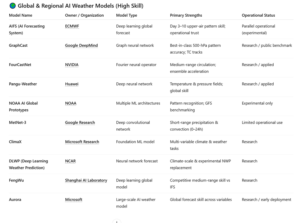
GFS and ECMWF Core vs AI details: (AI) just for reference ECMWF’s AI system (AIFS) is a fully separate, AI-native forecast model, not the traditional ECMWF model with machine learning layered on top. Unlike the main Integrated Forecasting System (IFS), AIFS does not solve physical equations; it uses deep learning trained on decades of reanalysis and operational forecast data to predict the next atmospheric state directly. It ingests similar inputs (pressure, temperature, wind, humidity fields) but produces forecasts via neural networks rather than numerical integration. The operational IFS remains the authoritative, physics-based backbone for warnings, ensembles, and high-impact decision support. ECMWF runs AIFS in parallel, comparing skill, speed, and bias against IFS at multiple lead times. In medium-range forecasts (≈3–10 days), AIFS has shown skill comparable to—and in some metrics better than—the full physics model, at a fraction of the computational cost. Key takeaways Separate model: AIFS is independent from IFS, not a post-processing or hybrid add-on Massively faster: Enables rapid global forecasts and large ensembles with minimal compute Complementary role: IFS provides physical realism and extremes; AIFS adds speed and pattern skill AIFS (AI Forecasting System): Research & development: 2022–2023 First real-time parallel runs: mid-2023 Publicly released experimental real-time forecasts: 2024 Status today: Operational parallel model (not replacing IFS) ECMWF was the first major global center to run an AI-native global model continuously in real time. -------------------------------------------------------------------------------------------------------------------------------------- NOAA’s GFS AI efforts are not a single AI-native replacement model like ECMWF’s AIFS, but a combination of experimental AI models and AI-enhanced components run alongside the main GFS. The operational GFS remains a fully physics-based numerical weather prediction system using the FV3 dynamical core. NOAA’s AI models are trained on decades of global reanalysis and past GFS outputs to forecast future atmospheric states directly, without explicitly solving physical equations. These AI forecasts are run in parallel to GFS for evaluation, research, and medium-range pattern guidance rather than operational warnings. In addition, machine learning is increasingly used inside the GFS workflow to improve data quality control, parameterizations, and bias correction. The strategy prioritizes reliability and explainability, with AI enhancing—but not replacing—the core physics model. Key takeaways Hybrid approach: Physics-based GFS plus separate experimental AI models No AI-only operational GFS: AI runs inform and augment forecasts, not replace them Risk-aware path: Emphasis on safety, interpretability, and gradual adoption NOAA (GFS + AI) GFS (physics model): Operational since the 1980s (FV3 core since 2019) NOAA AI global models: Research pilots (ML weather prototypes): 2021–2022 Sustained real-time parallel AI runs: 2023 Expanded evaluation vs GFS: 2024–2025 Status today: Experimental / evaluation only (not operational) NOAA deliberately moved slower and more conservatively than ECMWF. ------------------------------------------------------------------------------------------------------------------------------------ At 96h (Day 4), ECMWF’s physics-based IFS/HRES and the AI model (AIFS) are often very close on large-scale “pattern” skill (e.g., 500-hPa height), with AIFS frequently matching IFS despite being cheaper to run. At 144h (Day 6), verification shown by ECMWF commonly has AIFS slightly ahead on upper-air headline scores (ACC/RMSE for fields like 500-hPa geopotential height), which is exactly where ML models tend to shine. At 168h (Day 7), AIFS’ advantage can persist for broad circulation patterns, but that does not mean it’s “better at everything.” IFS still tends to win on fine-scale/high-impact details that depend on explicit physics and higher resolution (e.g., local precipitation structure, boundary-layer processes), while AIFS can be more “smooth” because it’s learned and typically coarser. Importantly, AIFS is its own model (AI-native), but it uses the same initial conditions as IFS (from ECMWF’s assimilation/analysis pipeline), so the comparison is about the forecast engine, not the starting point. Bottom line: by Day 4/6/7, AIFS often matches or edges IFS on upper-air pattern skill, while IFS remains stronger for physically constrained, local extremes and “weather sensible” detail. 96h: usually “tie-ish” on big patterns; IFS often better on local detail 144h: AIFS commonly slightly better on headline upper-air skill (pattern metrics) 168h: AIFS can stay ahead on large scales, but IFS remains the safer bet for extremes/structure ---------------------------------------------------------------------------------------------------------------------------- NOAA’s physics-based GFS still outperforms its experimental AI models at shorter lead times, especially where mesoscale detail and physical constraints matter. At 96 hours (Day 4), the operational GFS generally verifies better against observations for precipitation placement, fronts, and boundary-layer–driven features, while AI runs are competitive mainly on broad upper-air patterns. By 144 hours (Day 6), NOAA’s parallel AI models often match GFS on large-scale circulation metrics (e.g., 500-mb height anomalies) but begin to diverge more in sensible weather details. At 168 hours (Day 7), AI models can sometimes show similar or slightly better pattern skill than GFS, reflecting strengths in learned climatology and flow regimes. However, GFS remains more reliable for physically rare or extreme events (strong cyclogenesis, sharp gradients, convective outbreaks). Because NOAA’s AI systems are still experimental and not ensemble-anchored, GFS remains the authoritative model for verification, warnings, and downstream products. Key takeaways 96h: GFS usually verifies better overall; AI competitive mainly on upper-air patterns 144h: AI ≈ GFS on large scales; GFS better on precipitation and structure 168h: AI can edge pattern scores, but GFS remains stronger for extremes and decision use Highest overall pattern skill (global): GraphCast ECMWF AIFS FourCastNet / Pangu-Weather Best operational reliability: ECMWF IFS NOAA GFS Best short-range precipitation AI: MetNet-3
-
Records: Highs: EWR: 64 (1951) NYC: 64 (1951) LGA: 64 (1951) JFK: 58 (1972) Lows: EWR: -2 (1994) NYC: -2 (1994) LGA: -2 (1994) JFK: 0 (1994) Historical: 1786: The reading of -24° at Hartford, CT was the coldest temperature ever seen on a thermometer up to that time. (Ref. AccWeather Weather History) 1810 - The famous "cold day" in New England. Gale force winds wrecked homes, and accompanied a sudden overnight drop in temperature of 50 degrees. Tradgedy struck Sanbornton NH where three chidren froze to death. (David Ludlum) 1857: The Great Blizzard and Freeze, Jan. 18-19, 1857: More than a foot of snow fell with temperatures below 20°F across the state. Strong winds caused structural damage on land, wrecked ships at sea and great drifts that blocked transportation through the state. One report states that Norfolk was buried under 20 foot drifts of snow. Washington, DC got 14 to 24 inches, with drifts four feet deep; Portsmouth reported 16 inches; Halifax, about 16 inches with drifts to five feet; Brunswick County reported 18 inches; Prince George County 15 inches; Christiansburg measured 14 inches; and Winchester 8 inches. Richmond was cut off from Washington, DC for seven days. The Richmond Enquirer's editor remarked, "Sunday last we had one of the severest snowstorms which has occurred in this area for many years. Snow commenced falling about 7 pm Saturday night and by Sunday morning the wind had increased to a perfect gale - all day Sunday and Sunday night the snow fell rapidly accompanied by high winds which banked up the snow in some places as high as seven or eight feet. On average we would think the snow about two feet deep." Temperatures fell below zero after the storm: Christiansburg reported -8°F; a Petersburg newspaper reported the temperature in the city dropped from -15°F to -22°F; temperatures fell to between -10° to -17° in Halifax; at Portsmouth, it was -5°F. The cold was so extreme that all Virginia rivers were frozen over. The Chesapeake Bay was solid ice a 1 ½ miles out from its coast. At Cape Henry, one could walk out 100 yards from the lighthouse on the frozen ocean. (Ref. Virginia Weather History) (Ref. Early American Winters Vol. II 1821-1870 by David M. Ludlum pp. 113 - 114) 1893: Even more dramatic was the 42 degree increase in temperature in just 15 minutes that occurred at Fort Assinboine, Montana, on January 19, 1893. (Extreme Weather p. 68, by Christopher C. Burt) 1925: Maine recorded a minimum temperature of (-48F) at Van Buren a record until january 16, 2009 when a -50 °F was recorded at Big Black River, ME. (Ref. AccWeather Weather History) 1933 - Giant Forest CA received 60 inches of snow in just 24 hours, a state record, and the second highest 24 hour total of record for the U.S. (David Ludlum) 1961: Eight inches of snow fell and caused crippling traffic jams around the Washington D.C. area on the eve of John Kennedy's inauguration. The president-elect had to cancel dinner plans and, in a struggle to keep other commitments, reportedly had only 4 hours of sleep. Former President Herbert Hoover was unable to fly into Washington National Airport due to the weather, and he had to miss the swearing-in ceremony. 1961: The Kennedy inaugural snowstorm began as low pressure centered in northern Tennessee on the morning of the 19th. It was starved for moisture and only produce light snows to the north of the track but by the afternoon of the 19th the storm center moved to Virginia and then "exploded" near the coast. and snowfall quickly developed over the Washington, DC area. By evening the rate of snowfall intensified and winds increased from the Northeast to 25 mph National Airport reported visibility of zero and a total white out. The snow tapered off by midnight leaving 7.7 inches it National Airport to liquid equivalent was 1.14 inches which was more than typical of 11 inches storm. General and about 8 inches fell throughout the metropolitan area. Snowfall amounts were less to the south with Richmond receiving only 1 inch and areas in the northern Maryland region had as much as 16 inches of snow. The temperature did not rise above freezing for 11 days is not until January 31st when the high temperature reached 33 degrees Fahrenheit. (p. 71-73 Washington Weather Book 2002 by Ambrose, Henry, Weiss) January 19-20 1961 from North Carolina to New York. Virginia saw up to 12 inches. It caused a great traffic jam in northern and central Virginia and D.C.. Two deaths were blamed on the storm in Virginia, due to overexertion and accidents. (Ref. Virginia Weather History) Ref. (NWS Ranking for Storms between 1956 and 2011) This is the 28th Worst Snowstorm 1971: High pressure across the Great Basin brought record heat to parts of the Southwest. It was 90° at Borrego Springs, CA their highest temperature on record for January. Other daily record highs for the date included: Downtown Los Angeles, CA: 92°, Palm Springs, CA: 91°, Riverside, CA: 88°, Phoenix, AZ: 88°, Yuma, AZ 88°, Tucson, AZ: 85°, Victorville, CA: 77°, Palomar Mountain, CA: 75°, Las Vegas, NV: 74°, Idyllwild, CA: 74°, Bishop, CA: 72°, Big Bear Lake, CA: 68°, Winnemucca, NV: 67° and Flagstaff, AZ: 59°. (Ref. Wilson Wx. History) 1977 - Snowflakes were observed at Homestead and Miami Beach in extreme southern Florida. (David Ludlum) 1987 - A storm tracking toward the northeastern U.S. produced up to 14 inches of snow in northern Indiana. Peru IN reported a foot of snow. Six cities in Florida reported new record high temperatures for the date. The afternoon high of 88 degrees at Miami equalled their record for the month of January. (National Weather Summary) (Storm Data) 1988 - A powerful storm hit the central U.S. producing blizzard conditions in the Central High Plains, and severe thunderstorms in the Lower Mississippi Valley. Snowfall totals ranged up to 36 inches at Wolf Creek Pass CO, with 31 inches at Elsmere NE. Tornadoes claimed five lives in Tennessee, and a tornado at Cullman AL injured 35 persons. (National Weather Summary) (Storm Data) 1989 - The high temperature for the day at Fairbanks, AK, was a frigid 41 degrees below zero, and the morning low of 24 degrees below zero at Anchorage AK was their coldest reading in fourteen years. (National Weather Summary) 1990 - Thunderstorms produced large hail and damaging winds in eastern Texas and Louisiana. Tornadoes at Garland TX and Apple Springs TX each injured one person. Heavy snow spread from the Southern and Central Rockies into the Great Plains. Storm totals in New Mexico reached 36 inches at Gascon. Totals in the Central Plains ranged up to 15 inches near McCook NE and Garden City KS. (National Weather Summary) (Storm Data) 1993: An unusual series of Pacific storm systems tracked across Arizona from January 6th through the 19th, producing heavy and prolonged precipitation across the state. These heavy rains caused the most widespread and severe flooding in Arizona since the turn of the century. The protracted rainfall over the 2 weeks caused multiple flood peaks on most streams and rivers. A large garbage landfill and portions of the new Mill Avenue Bridge under construction were washed away by the raging Salt River. The Gillespie Dam west of Phoenix was damaged as high water spread throughout low-lying areas. One man drowned while trying to cross the Agua Fria River. 1994: Very cold at Annandale, VA Maximum only +6°F at 1450 hrs. Minimum -7° at 0838 hrs. (Annandale Weather Records) National Airport Maximum 8° one degree from the lowest maximum this century. The minimum temperature was -4°F That makes this day one of only five days in the official climate history of Washington (11-1-1870- present) to have a maximum temperature less than 10 degrees F. The first time was on 12-30-1880 when the high was 9 °F and the second was 12-30-1917 when the high was 9 degrees F. A high temperature of 8 °F has occurred twice also - the first time was this date (1-13-1912) and the second time was 1-19-1994. The coldest maximum ever recorded in Washington, DC occurred on 2-10-1899: 4 °F (Washington Weather Records - Stanley Rossen) Arctic outbreak settles in with nearly 100 records, 14 cities coldest ever. Parish, NY picked up several hours of snow accompanied by thunder and lightning with forty-two inches of new snow falling as lake effect snows continued off of Lake Ontario. New Whitehead, IN -36 °F sets all time state record low temperature Greenbank, WV -35 °F, Bethel, OH -40 °F, St. Cloud, MN -50 °F and Shelbyville, KY set a new record low for the state of KY at - 37 °F. (Bob Ryan's 2000 Almanac) This a.m. was the coldest in many years across parts of the eastern Corn Belt of Ohio and the Great Lakes. -37°F at New Whiteland, Indiana, set Indiana's all-time cold record by 1°. All time record lows included -27° at Indianapolis Indiana and -22° at Pittsburgh Pennsylvania. (Weather Guide Calendar with Phenomenal Weather Events 2007 Accord Publishing, USA) 1995: 19.7 inches of snow fell on Columbia, MO. The storm would break records for the greatest twenty-four hour snowfall and greatest single snowstorm total. Blizzard conditions resulted as winds gusted to 45 mph. (Ref. AccWeather Weather History) 1996: January 1996 is known as one of the worst snowmelt floods on record for the Mid-Atlantic. The region saw blizzard conditions on January 6 and 7th, which produced 15 to 24 inches east of I-95, and 2 to 3 feet of snow west of I-95. With a tremendous amount of snow on the ground, on January 19, temperatures soared into the 50s and 60s ahead of an approaching cold front. At 7 am in Washington, D.C., was reporting a temperature of 60 degrees with a dewpoint of 60 degrees, both unusually high for a January morning. The warm temperatures combined with rain to melt much of the snowpack, released into the waterways. 1996: Moderate to heavy rains and an incredible snowmelt triggered by a rapid warm-up caused serious flooding along the Delaware, Susquehanna, upper Ohio, Potomac and James River basins in Pennsylvania, with crests as much as twenty feet above flood stage. The flooding killed thirty-three people, forced over 200,000 from their homes, and destroyed or damaged hundreds of roads and bridges. January 19-22, 1996: Just one week after 2 to 4 feet of snow fell over western Virginia, temperatures warmed into the 60°s ahead of a front which brought thunderstorms and heavy rain. The sudden warm-up caused a rapid snow melt. The melted snow was the equivalent of 2 to 4 inches of rain. Some areas saw another 2 to 5 inches of rainfall on top of the melted snow. The saturated ground meant that all the rain and snow became run off into the streams and rivers, which could not handle it. Major flooding resulted. This sort of event had not happened since March 1936. (Ref. Virginia Weather History)
-
20 / 14 a total of 5.4 from the 36 hour affair 0.34 LE. Cold to hold overall and outside of Thu surge to the mid/upper 40s it look mainy at or sub freezing through the 29th. The much discussed WAA/overrunning threat 1/25 or a bit earlier. Deep cold (coldest potentially since - we'll see) 1/20, 1/24-1/25 , 1/26 - 1/29. The parallels to 94 continue not exact but clear parallels.
-
32 -SN here. Picking up
-
radar filling in a bit
-
Round 1 yielded around 1.5 - 2.0 here. Total of 3.4 here (so far since Saturday) we'll have to watch the coastal and how much it throws back later this afternoon.
-
Lull 11 - evening
-
There is the SE snow
-
We'll see how things progress with the coldest air on this side starting next week and overrunning potential.
-
Could be some interesting parallels to 1994 ahead this and next (1/25) week.
-
Records: Highs: EWR: 66 (1990) NYC: 66 (1990) LGA: 64 (1990) JFK: 59 (1990) Lows: EWR: -7 (1982) NYC: 0 (1982) LGA: 0 (1982) JFK: 0 (1982) Historical: 1857 - A great cold storm swept across the Atlantic Seaboard. Snowfall totals of 12 inches were common, whole gales caused shipwrecks and damage property on islands, and temperatures near zero prevailed from Virginia northward. Great drifts of snow blocked transportation. Richmond VA was cut off from Washington DC for a week. (David Ludlum) 1857: Both Washington and Baltimore received 24 inches of snow from this storm and by the 19th with drifts up to 10 feet. Norfolk, VA reported snowdrifts as high as 20 feet. At Williamsburg, VA the temperature was only 3°F at the height of the snowstorm. The cold air behind the storm penetrated into Florida where the site of present day Miami had a temperature of 30°F. Boston reported a barometer of 28.91 inches during this storm. (p.34-35 Washington Weather Book 2002 by Ambrose, Henry, Weiss) 1893: The minimum temperature for the date is -6°F. in Washington, DC. (Ref. Washington Weather Records - KDCA) 1930: Oklahoma's coldest night on record occurred as the town of Watts dropped to -27 °F. (Ref. AccWeather Weather History) 1943: Idaho's coldest night on record occurred as the low temperature dropped to 60 degrees below zero at Island Park Dam. 1950: Oregon continued in the grips of one of its worst winter months ever. A significant winter storm brought a thick glaze of ice to Columbia River Gorge, stopping automobile traffic in its tracks. Hundreds of motorists were stranded and had to be rescued by train. Even that wasn't easy with the coating of ice. The storm caused widespread power outages. 1957: The record low temperature for the state of Massachusetts was set at Birch Hill Dam when the mercury fell to -35°. This was broken on 1/22/1984 at Chester, MA with a minimum temperature of -40 °F. (Ref. Wilson Wx. History) 1959: Cold night in the Shenandoah Valley as Dale Enterprise had a low temperature of -4 °F and Naked Creek in Rockingham County, Virginia recorded a minimum of -14.5 °F. (Ref. Daily News Record Newspaper - Harrisonburg, Virginia) 1969: The maximum temperature for the date in Washington, DC is 69°F. (Ref. Washington Weather Records - KDCA) Heavy rains of tropical origin began on this day and ended on the 28th. As much as 50 inches of rain fell at 7,700 feet. 31 inches of rain fell on the south slopes of Mt. San Gorgonio, 15.5 inches at San Jacinto Peak, around 10 inches at Banning, less than one inch from Indio southeast. 87 people were reported dead from flooding and mudslides all over California. Scores died in traffic accidents. Hundreds of homes and buildings were destroyed in slides, including 14 destroyed and 11 damaged homes in Mt. Baldy Village. 50 homes near Forest Home (Forest Falls) were damaged by flooding. Highways and railroads washed out. Power outages occurred. Cucamonga Creek itself caused $10 million in damage. The Mojave River took out numerous bridges and flooded farmlands in the upper desert. (Ref. Wilson Wx. History) 1971: A remarkable record at Los Angeles California. Today's high of 95°F set the city's all time record January high shattering the old record by 5°. This is only 3° less than the United States January record high of 98°F set in Fort McIntosh, Texas on January 18, 1914 and Laredo Texas on January 17, 1936. (Weather Guide Calendar with Phenomenal Weather Events 2007 Accord Publishing, USA) 1971: A warm Santa Ana condition brought a 95 degree reading to Los Angeles, the highest January temperature on record. It was 95 degrees in Palm Springs, the highest temperature on record for January as well. 1973 - A baby was carried 300 to 400 yards by the strong winds of a tornado at Corey LA, yet received only minor injuries. (The Weather Channel) 1978: In Connecticut, the Hartford Arena collapsed after experiencing the largest snowstorm of its 5-year life. Multiple issues caused the collapse. 1982: Extreme cold in the Northeast: Princeton, NJ recorded -9F and Bridgehampton, NY, on Long Island, dropped to -10F. (Ref. AccWeather Weather History) 1987 - A storm in the south central U.S. blanketed Oklahoma City with eight inches of snow, their highest total since 1948. Snowfall totals in Oklahoma ranged up to 13 inches at Gage, with drifts five feet high. Roof collapses across the state resulted in seven million dollars damage. (National Weather Summary) (Storm Data) 1988 - A storm in the southwestern U.S. produced a 15 to 20 foot surf along the southern coast of California resulting in more than fifty million dollars damage. A small tornado in Orange County CA lifted a baseball dugout fifteen feet into the air and deposited it in the street, 150 yards away. The same storm also produced 26 inches of snow at Duck Creek UT. (National Weather Summary) (Storm Data) 1989 - While fair and mild weather prevailed across the forty-eight states, bitter cold gripped Alaska. The high temperature for the day at Fairbanks was 30 degrees below zero. Thunderstorms along the western Gulf coast drenched parts of southwest Houston with more than four inches of rain. (National Weather Summary) 1990 - A winter storm produced heavy snow and high winds across the southwestern U.S. Snowfall totals ranged up to 18 inches at Lake Arrowhead CA and Ashford AZ. High winds in New Mexico gusted to 100 mph east of Albuquerque. Unseasonably warm weather continued from Texas to the Atlantic coast. Twenty cities reported record high temperatures for the date including Roanoke VA with a reading of 71 degrees. (National Weather Summary) (Storm Data) 1992: Up to seven inches of snow fell across North Alabama in an unusual snowstorm. (Ref. AccWeather Weather History) 1993: A cold blast of air over the Great Lakes and Ohio Valley: Chicago's high temperature only reached -11F degrees, tying the record for the coldest high temperature that the Windy City has ever recorded. Tower, MN fell to -44F. Thirty-six inches of snow fell in just nine hours at Adams, NY. (Ref. AccWeather Weather History) Salt Lake City broke its seasonal snowfall when the total reached severity-six inches.(Ref. AccWeather Weather History) 1994: Great Arctic outbreak of 1994 begins on 17th and 18th. The massive overrunning snowstorm that had buried the Tennessee and Ohio Valleys the day before moved northeastward and clobbered interior sections of New England and the Mid Atlantic. The Washington, DC area received up to 2 inches of ice. 10 to 20 inches of snow fell from West Virginia to parts of New England. Two day snowfall totals included 24 inches at Grafton, NH, 23 inches at Long Pond, PA, 22 inches at Patten, ME & Hanover, NH, 20 inches at Eustis, ME, and 19 inches at Caribou, ME. 20 inches of new snow at Jay Peak, VT raised their snow cover to 91 inches. Wilkes-Barre Scranton, PA checked in with 16.6 inches, which brought their monthly snowfall to 36.9 inches, their snowiest January on record. Chicago 21°F below zero was near the all time record low which is -27 °F set on January 20, 1985 and Tower, MN dropped to -44 °F. (Ref. Wx.Doctor) Behind the storm, the next blast of arctic air spread over the Great Lakes and Ohio Valley. Chicago, IL’s high temperature only reached -11°, tying the record for the coldest high temperature that the Windy City has ever recorded (12/24/1983).(Ref. Wiki.Answers.Com) Governor Arne Carlson ordered all Minnesota public schools closed due to the extreme cold and severe winter weather. Morning readings were in the 30-below-zero range. The biggest problem was from high winds that came with the cold and very low windchills. (Ref. AccWeather Weather History) 1995: An area of low pressure developed over eastern Texas and intensified as it moved northeast to southern Illinois. This storm produced a band of heavy snow from portions of northeast Oklahoma to northwest Illinois bringing transportation to a halt for two days. Columbia, MO reported their greatest 24-hour snowfall on record with 19.7 inches. At Springfield, MO 14.4 inches fell through the next day, making it the heaviest 24 hour snowfall since 1980. Total damage was estimated at $2.5 million dollars. What made this storm unusual was the occurrence of thundersnow in many locations across southwest Missouri at height of the storm (Ref. Wilson Wx. History) 1996: Heavy rain and snowmelt from deep snow packs over New England resulted in massive flooding and caused the evacuation of 125,000 people. 80 people died and damage totaled $1 billion dollars. (Ref. AccWeather Weather History) 1999: A microburst in a thunderstorm gave winds to 86 mph that imploded a greenhouse in Bridgehampton New York. Fortunately there were no injuries. (Ref. Weather Guide Calendar with Phenomenal Weather Events 2012 Accord Pub. 2011, USA)
-
Seeing some -25c or colder 850 temps showing up between 1/25 - 1/28 consecutively on recent runs.
-
28 / 22 light snow about 1.5 from this latest batch about 1.8 yesterday. More snow later as coastal throws back moisture. Cold the story the next 7 - 10 days with intervals much below normal cold and potential WAA / overrunning snows in the 1/24 - 1/27 range. 1/18: Snow today 1 - 4 overall 1/19 - 1/23 : Overall Cold below normal (Much below normal 1/20 highs 20s / lows singles digis inland) 1/24 - 1/31: Continued cold - Arctic clipper / front - 1/24, WAA/overrunning potential 1/25-1/27. Very cold period 1/25-1/28 could see single digits to the coast / metro 2/1 - beyond : Moderation
-
About an inch / 1.5 here in CNJ
-
2001 for WWBB and 2005 for Easwv
-
Blast from the past https://web.archive.org/web/20010716085355/http://www.wright-weather.com/cgi-bin-bb/forumdisplay.cgi?action=topics&forum=Forecasting+Discussion&number=11&DaysPrune=30&LastLogin= and Eastern: https://web.archive.org/web/20050830180446/http://www.easternuswx.com/bb/index.php?showforum=15 https://web.archive.org/web/20070723185323/http://www.easternuswx.com/bb/index.php?s=980fc25961b85ed5fa34867e78d823ea&showforum=15 https://web.archive.org/web/20071206104317/http://www.easternuswx.com/bb/index.php?s=987bbd2674ef73d847e9f34ef6ee8ec5&showforum=15
-
Mostly heavy snow here in CNJ (Monroe) some sleet mixed in 85/15 snow
-
-
-


