

SACRUS
-
Posts
15,490 -
Joined
-
Last visited
Content Type
Profiles
Blogs
Forums
American Weather
Media Demo
Store
Gallery
Everything posted by SACRUS
-
I think there were mostly sunny forecasts for today as recent as Sunday morning and many were showing partly cloudy / to partly sunny all day even last night or this early morning. Looks like clouds or mainly cloudy till at least noon or 1 PM (besides the smoke/haze.
-
Records: Highs: EWR: 102 (1944) NYC: 101 (1944) LGA: 100 (1955) JFK: 96 (2010) Lows: EWR: 57 (1951) NYC: 56 (1951) LGA: 57 (1972) JFK: 60 (1959) Historical: 1843 - A spectacular cloudburst near Philadelphia turned the small creeks and streams entering the Delaware River into raging torrents. As much as sixteen inches of rain fell in just three hours. Flooding destroyed thirty-two county bridges, and caused nineteen deaths. It is believed that several small tornadoes accompanied the torrential rains, one of which upset and sank more than thirty barges on the Schuylkill River. (David Ludlum) 1875: Several tornadoes moved across northern and central Illinois. One of the stronger tornadoes touched down in Warren and Knox County where it destroyed 25 homes and killed two people. Another in a series of tornadoes touched down near Knoxville and moved east into northern Peoria County. This estimated F4 tornado injured 40 people and was described by eyewitnesses as looking like a "monstrous haystack." 1904: Detroit Lakes woman is hit by lightning. It melted her hairpins and steel in corset but does not kill her.(Ref. AccWeather Weather History) 1915: Fort Wayne, IN set their coldest August high temperature with 60°. (Ref. Wilson Wx. History) 1961 - The temperature at Ice Harbor Dam, WA, soared to 118 degrees to equal the state record established at Wahluke on the 24th of July in 1928. The afternoon high of 111 degrees at Havre, MT, was an all-time record for that location. (The Weather Channel) 1961: McAllen, Texas: McAllen sets a new record high on Wednesday when the temperature soars to 105 °F. McAllen has now set a new record high on all but one day so far this month. (Ref. WxDoctor) 1974: Fort Walton Beach, Fla.--Lightning struck an aluminum ladder at a construction project. The man on the ladder was killed, three nearby workmen were injured. (Ref. Lightning-The Underrated Killer.pdf) 1980: Hurricane Allen was one of the most intense hurricanes ever observed in the Atlantic. On this date, the hurricane reached Category 5 status for the first of three times during its long path across the Atlantic as reconnaissance aircraft measured a 911 millibars (26.90 inches of mercury) pressure in the eastern Caribbean while south of Puerto Rico. Later this day, Allen moved across Haiti, ruining much of the country's coffee crop and killing 220 people.Casper, WY established new record low of 39°; breaking the previous record by 9 degrees. (Ref. AccWeather Weather History) 1983: Very heavy thunderstorms hit the southern portion of metro Denver, CO. 2.89 inches of rain fell in just 38 minutes causing widespread street flooding in southeast Denver. Two feet of water covered a section of Interstate 25. Hail up to golf ball size accompanied the storm in Littleton and Englewood along with 60 mph winds. (Ref. AccWeather Weather History) 1987 - Severe thunderstorms raked eastern South Dakota. The thunderstorms spawned half a dozen tornadoes, produced softball size hail at Bowdle, and produced wind gusts to 90 mph south of Watertown. Hot weather continued in eastern Texas. Afternoon highs of 100 degrees at Houston and 106 degrees at Waco equalled records for the date. (The National Weather Summary) (Storm Data) 1988 - Thunderstorms produced severe weather from Indiana and Lower Michigan to Pennsylvania and New York State during the day. Thunderstorms in Michigan produced wind gusts to 80 mph at Ashley, Hastings and Lennon. (The National Weather Summary) (Storm Data) 1989 - Thunderstorms produced severe weather in Oklahoma, and from Iowa to the Upper Ohio Valley, with 216 reports of large hail or damaging winds between early Saturday morning and early Sunday morning. Thunderstorms moving across Iowa around sunrise produced extremely high winds which caused ten million dollars damage to crops in Carroll and Greene Counties. Thunderstorm winds at Jefferson IA reached 102 mph. Afternoon thunderstorms produced tennis ball size hail at Bay Mills, WI. (Storm Data) (The National Weather Summary) 1995: Near Deerfield, KS, hail piled in huge drifts and stripped corn in a two mile wide swath. Hail drifts were still evident 24 hours later. Rain of over six inches in a short time caused flash flooding in the Deerfield area. Highway 50 was covered by three feet of water and was closed for several hours and limited to one way traffic for 24 hours. Sand was deposited on many streets bringing out heavy equipment to clear the debris. (Ref. Wilson Wx. History) 1999: Governors of four Mid-Atlantic States imposed mandatory water restrictions as the worst drought in the history of the region continued. The period April through July ranked as the second driest ever for the Northeast, second only to 1965. (Ref. Wilson Wx. History) 2000: A wet microburst with winds estimated at 120 mph caused heavy damage in and around Mitchell, SD. Apartments and several mobile homes were destroyed, vehicles were overturned, and other damage occurred to buildings and vehicles. Widespread tree and power line damage also occurred. 10 people were injured, although the majority of the injuries were minor. The damage path was approximately a mile and a half long and a mile wide, extending over the southwest part of Mitchell. (Ref. Wilson Wx. History) 2002: Tropical Storm Bertha became the first tropical system of the 2002 Atlantic hurricane to make a U.S. landfall. Bertha dumped 7.15 inches of rain on Pascagoula, MS in 24 hours. (Ref. Wilson Wx. History) 2020: Tropical Storm Isaias hit the eastern third of Virginia hardest on Tuesday morning during its brief but destructive journey up the Eastern Seaboard. Several hours of torrential rain flooded dozens of roads, while winds gusting past 45 mph downed trees and put hundreds of thousands of homes and businesses in the dark. The storm left scattered road closures and power outages in metro Richmond and more widespread disruption across the Tidewater region, where winds approached 70 mph. No serious damage was reported in the western half of the state. (Ref. The Richmond Times Dispatch)
-
71 / 67 - cloudy. Clouds will limit any shot at 90 still warm / humid mid - upper 80s, enough sun could get the hotter spots to 90. Cooler Wed, cloudy and isolated showers in the PM/ overnight. Clear out Thu and a great stretch Thu - Sunday - mainly clear, dry and near to slightly below normal. Flow comes around later on the 8/10-11 with a warm - hot / humid and wetter overall. Heat more widespread Tue - Thu next week. Flow still a bit onshore-ish. Tropics activity but overall ridging into the EC, - warm - hot at times , more humid and wetter with frontal boundaries and tropical systems to be watched. 8/5 - 8/10 : Overall near normal - dry 8/11 - Beyond : Warm- Hot - Humid - wetter overall - Tropical activity - heat 8/11 - 8/14 -tropics focus 8/15 onward. (Ctrl + Refresh) to update live satellite loop
-
4 Day cool start to August EWR: 8/1: 75 / 63 (-9) 8/2: 83 / 62 (-5) 8/3: 85 / 63 (-4) 8/4: 90 / 65 (0) NYC: 8/1: 73 / 63 (-10) 8/2: 80 . 63 (-5) 8/3: 84 / 64 (-3) 8/4: 89 / 67 (+1) LGA: 8/1: 73 / 64 (-10) 8/2: 81 / 65 (-6) 8/3: 84 / 67 (-3) 8/4: 89 / 71 (+1) JFK: 8/1: 74 / 65 (-6) 8/2: 80 / 62 (-5) 8/3: 83 / 63 (-3) 8/4: 86 / 67 (+1)
-
Highs: TEB: 91 EWR: 90 ISP: 89 New Brnswck: 89 PHL: 89 LGA: 89 NYC: 89 TTN: 87 JFK: 86 ACY: 86 BLM: 83 *
-
Highs: TEB: 91 EWR: 90 ISP: 89 New Brnswck: 89 PHL: 89 LGA: 89 NYC: 89 TTN: 87 JFK: 86 ACY: 86 BLM: 83 *
-
https://firesmoke.ca/forecasts/current/
-
87 / 56 another beaut of a day. Smoke/haze seems worse to the north
-
84 / 58 a touch more humid vs the past 2 days.
-
The area to watch in the coming 1 - 2 weeks off the s central atlantic.
-
Records: Highs: EWR: 100 (1993) NYC: 100 (1944) LGA: 99 (1944) JFK: 93 (2006) Lows: EWR: 58 (1945) NYC: 55 (1874) LGA: 62 (1964) JFK: 57 (1964) Historical: 1609: Sir Thomas Gates, future governor of Virginia, was on his way to England from Jamestown. On Saint James Day, while between Cuba and the Bahamas, a "most terrible and vehement storm" raged for 44 hours. One of the small vessels in the fleet sank to the bottom of the Florida Straits. Four of the remaining vessels reached Virginia soon after the storm...followed a few days later by three other ships. The flagship, known as Sea Adventure, disappeared and was presumed lost. A small bit of fortune befell the ship and her crew when they made landfall on Bermuda. Although the vessel was damaged on a surrounding coral reef, all survived and spent ten months on the unsettled isle. The Spaniards, though shipwrecked on the island many times, had failed to colonize there. The British claimed the island and quickly settled the subtropical isle. In May 1610, they set forth for Jamestown, this time arriving at their destination. This near catastrophe provided the inspiration and background for William Shakespeare's play, The Tempest. (Ref. The Tempest) 1882 - A vivid aurora was visible from Oregon to Maine, down the east coast as far as Mayport FL, and inland as far as Wellington KS. Observers at Louisville KY noted merry dancers across the sky, and observers at Saint Vincent, MN, noted it was probably the most brilliant ever seen at that location. (The Weather Channel) 1915: Tropical storm from the North Bahamas moved over the Washington, DC area on a northeast track gave 2.34 inches of rain and winds to 46 mph from the SE. (Ref. Washington Weather Records ) 75 people died in flooding at Erie, PA. Many streets were flooded and bridges washed away. (Ref. AccWeather Weather History) 1930: The temperature at Moorefield, WV soared to 112 degrees to establish a state record, having reached 110 degrees the previous day. Widespread drought after April of that year caused some towns to haul water for domestic use, and many manufacturing plants were barely operational.(The Weather Channel) (Ref. Additional Temperatures Listed On This Link) 1930 - The temperature at Moorefield, WV, soared to 112 degrees to establish a state record, having reached 110 degrees the previous day. Widespread drought after April of that year caused some towns to haul water for domestic use, and many manufacturing plants were barely operational. (The Weather Channel) 1961 - Spokane, WA, reached an all-time record high of 108 degrees. Kalispell, MT, set an all-time record with a reading of 105 degrees. (The Weather Channel) 1980 - A record forty-two consecutive days of 100 degree heat finally came to an end at the Dallas-Fort Worth Airport. July 1980 proved to be the hottest month of record with a mean temperature of 92 degrees. There was just one day of rain in July, and there was no measurable rain in August. There were 18 more days of 100 degree heat in August, and four in September. Hot weather that summer contributed to the deaths of 1200 people nationally, and losses from the heat across the country were estimated at twenty billion dollars. (David Ludlum) (The Weather Channel) 1981: This was a day to remember in portions of south central South Dakota as an unusually long lived thunderstorm wind event hit the area. In St. Francis a radio station reported a gust of 86 mph, but that was only the beginning. For the next 20 minutes winds of 50 to 70 mph hammered the area doing massive damage to trees and a few trailers in the area. (Ref. Wilson Wx. History) 1982: The low temperature at Billings, MT was 60°. This began a string of 19 consecutive days on which the low temperature did not drop below 60°, the record longest such streak in August. (Ref. Wilson Wx. History) 1987 - A cold front brought relief from the heat to a large part of the Midwest, while hot weather continued in the south central and eastern U.S. Morning thunderstorms in Nebraska deluged the town of Dalton with 8.71 inches of rain, along with hail three inches in diameter, which accumulated up to four feet deep near the town of Dix. (Storm Data) (The National Weather Summary) 1988 - Thunderstorms produced severe weather from eastern Iowa to Lower Michigan during the afternoon and evening hours, producing golf ball size hail and spawning several tornadoes. A thunderstorm at Maquoketa, IA, produced wind gusts to 75 mph. (Storm Data) (The National Weather Summary) 1989 - Thunderstorms produced severe weather from eastern Nebraska and northeastern Kansas to the Great Lakes Region, with 150 reports of large hail or damaging winds during the afternoon, evening, and nighttime hours. Thunderstorms produced tennis ball size hail at Claremont, MN, and wind gusts to 75 mph at Milwaukee, WI. Thunderstorms representing what once was Hurricane Chantal produced five inches of rain at Grant, MI, and deluged Chicago, IL, with more than three inches of rain in three hours. (Storm Data) (The National Weather Summary) 1994: Boston, Massachusetts had 16 days from July 20 to August 4 giving the greatest number of days with temperatures of 70 degrees or above. (Ref. NOAA Boston Weather Events) 1995: Thunderstorms over northwest Iowa storms grew quickly, producing golf ball to baseball size hail over Palo Alto County near Ayrshire and Webb. As the storms moved south, a copious amount of hail was dropped. Just north of Rush Lake in Palo Alto County, pea-sized hail covered the ground to a depth of 12 inches. The storms then moved into northern Pocahontas County where they dropped softball size hail, which has a diameter of 4.50 inches, just north of Laurens. Golf ball size hail also continued to fall over Pocahontas County near the communities of Pocahontas and Havelock. The storms weakened a bit as they moved into Sac and Calhoun Counties. Crop damage totaled about $335,000 from these storms. Record heat prevailed across parts of the East. Record highs included: Philadelphia, PA: 98°, LaGuardia Airport (NYC), NY: 96°, Wilmington, DE: 96° and Bridgeport, CT: 93°. (Ref. Wilson Wx. History) 1998: College Station, Texas: The last of a string of 30 consecutive days with temperatures greater than 100 °F. 49 such days will be recorded in the blistering Summer of '98. (Ref. WxDoctor) Dallas, TX saw its streak of 29 consecutive days with temperatures 100° or hotter come to an end. It was the second longest streak of 100° plus days in the city's history. Record highs occurred across the southwest including Borrego Springs, CA: 116°, Redding, CA: 112°, Victorville, CA: 110°, Stockton, CA: 109°, Sacramento, CA: 108°, Riverside, CA: 106°, Escondido, CA: 99°, Idyllwild, CA: 96°, Palomar Mountain, CA: 95° and Big Bear Lake, CA: 88° and San Francisco (Airport), CA: 87°. (Ref. Wilson Wx. History) 2006: Washington DC: The temperature at Ronald Reagan National Airport reaches 101 °F the hottest ever for that day in the nation's capitol. (Ref. WxDoctor) 2008: Severe storms moved across northern Illinois and Indiana with tornadoes and stiff winds reported. With tornado sirens blaring, the game at Wrigley Field between Cubs and Astros was stopped as fans were told to evacuate to the lower concourse. Passengers at O’Hare International Airport were evacuated to lower levels of buildings as well. An estimated 350 flights were canceled. 2012: Third of the top ten weather events - Summer Heat Wave. June 22-August 4. Extreme heat that began over the High Plains, expanded to the Fast Coast, and then centered on the Heartland broke thousands of temperature records and resulted in July 2012 edging out July 1936 as the hottest month on record for the contiguous United States. The heat, which was blamed for over 100 deaths, contributed to the drought that affected much of the country. Top 2012 Weather Events (Ref.Weatherwise May/June 2013 volumn 66 /number3 page 17) 2020: Tropical Storm Isaias hit the eastern third of Virginia hardest on Tuesday morning during its brief but destructive journey up the Eastern Seaboard. Several hours of torrential rain flooded dozens of roads, while winds gusting past 45 mph downed trees and put hundreds of thousands of homes and businesses in the dark. The storm left scattered road closures and power outages in metro Richmond and more widespread disruption across the Tidewater region, where winds approached 70 mph. No serious damage was reported in the western half of the state. (Ref. The Richmond Times Dispatch)(Ref. The Richmond Times Dispatch)
-
70 / 60 . Clear cloud-wise but smoke gets in your eyes. Warm mid - upper 80s , smoke may hinder the hottest spots from a 90 return. More cloudy Tuesday but still warm with mid - upper 80s hottest spots maybe to 90 but could be cloudy. We'll see how much rain can get north of SNJ later Wed / Thu AM. The late week and weekend look beautiful. Overall onshore barrage the next 4-5 days before the flow comes around next week warm-hot / humid and wetter overall with tropcial activity heating up. Atlantic ridge remains expanded or anchored off the coast offshore so storms may be steered and aimed towards the SE/EC. 8/4 - 8/8 : near normal - dry overall - (limited 90s to the hottest spots Mon/Tue) 8/8 - 8/12 : Warm - Hot / Humid - wetter (Tropics) 8/13 - Beyond : Overall warmer than normal - periods of heat , Wetter
-
Highs: TEB: 85 * erroneous 93 readning EWR: 85 PHL: 85 NYC: 84 LGA: 84 New Brnswck: 84 JFK: 83 ISP: 83 TTN: 83 BLM: 81 * missing most data ACY: 81
-
JFK 1963 heat late June / July June 23 89 60 0.00 0.0 June 24 89 63 0.00 0.0 June 25 94 68 0.00 0.0 June 26 96 70 0.00 0.0 June 27 98 70 0.00 0.0 June 28 95 73 0.00 0.0 June 29 82 70 0.01 0.0 June 30 86 70 0.00 0.0 July 1963 JFK Airport Weather Day High (°F) Low (°F) Precip. (inches) Snow (inches) July 1 102 71 0.00 0.0 July 2 93 72 0.00 0.0 July 3 89 63 0.00 0.0 July 4 83 62 0.00 0.0 July 5 89 63 0.00 0.0 July 6 83 62 0.00 0.0 July 7 79 62 0.04 0.0 July 8 75 62 0.26 0.0 July 9 79 55 0.00 0.0 July 10 79 58 0.00 0.0 July 11 83 63 0.00 0.0 July 12 84 62 0.00 0.0 July 13 78 59 0.02 0.0 July 14 73 63 0.26 0.0 July 15 86 67 0.00 0.0 July 16 86 67 0.00 0.0 July 17 92 70 0.00 0.0 July 18 89 72 0.00 0.0 July 19 97 70 0.13 0.0 July 20 81 65 1.07 0.0 July 21 82 66 0.08 0.0 July 22 75 66 0.00 0.0 July 23 77 65 0.00 0.0 July 24 85 66 0.00 0.0 July 25 85 68 0.00 0.0 July 26 90 70 0.00 0.0 July 27 97 71 0.00 0.0 July 28 95 73 0.07 0.0 July 29 95 73 0.02 0.0 July 30 89 71 0.86 0.0 July 31 81 62 0.00 0.0
-
Haze / smoke cleared from here, but more wrapping around the NNE transport
-
Yes 102 Jul 1, 1963 in JFK
-
81 / 51 a true gem today
-
Looks possible in EWR/ NJ - away from the coast.
-
For strong heat (95+) 2002 was tied (edit thought it was 6 in 83) JFK - assume we are talking about JFK Year Rank Days >= 95 °F 2010 1 10 1963 2 8 2002 3 7 1999 3 7 1983 3 7 2013 6 6 1949 6 6 2012 8 5 1966 8 5 1955 8 5 2022 11 4 2006 11 4 1993 11 4
-
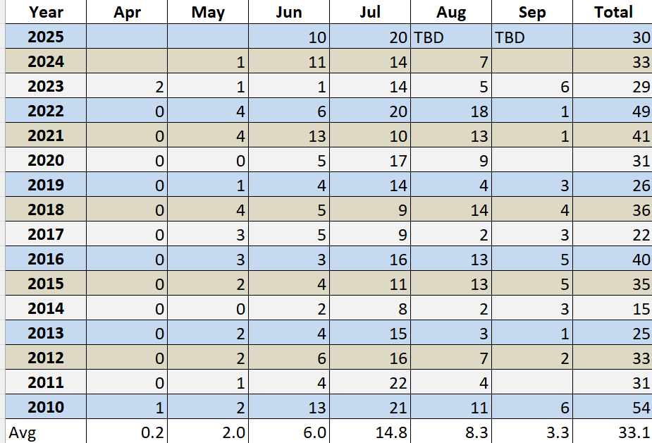
Expanded data back to 2010 - looks like Mon, Tue then 8/10 and beyond could add to those - no strong heat (95+) but do see plenty of 88 - 91 days through the 13/14th before perhaps more sustained warmth / heat towards the middle , second half of august. EWR can get there with a N/NNE/E with right amount of sun.
-
Records: Highs: EWR: 101 (2006) NYC: 97 (2005) LGA: 100 (2006) JFK: 99 (2006) Lows: EWR: 57 (1953) NYC: 55 (1927) LGA: 59 (1953) JFK: 56 (1964) Historical: 1864: A waterspout over Albemarle Sound, NC passed perilously close to the Union Fleet at anchor. The crews of the ships watched "in awe" as the whirlwind dissipated as it moved onshore. (Ref. Wilson Wx. History) 1885 - A tornado hit Philadelphia and Camden along its eight mile path. (David Ludlum) 1885: A tornado causing estimated F3 damage hit Philadelphia and Camden along its eight-mile path. Six people were killed and damage totaled $500,000 dollars. Other tornadoes causing estimated F2 damage touched down in Cecil County, Maryland, New Castle County, Delaware and Bucks & Chester Counties in Pennsylvania. (David Ludlum) 1894: After two record heat waves in July, record cool weather arrives. Lansing, MI fell to 32° for a rare summer freezing temperature. (Ref. Wilson Wx. History) 1898: Philadelphia, PA had one of their worst thunderstorms ever when 5.84 inches fell in just 2 hours. The hydraulic pressure in the city sewers caused by the force of the accumulated runoff created overflows via toilets, basins, and sinks to rise to second floor levels in some cases. (Ref. AccWeather Weather History) 1899: A tropical depression was born in the tropical Atlantic. Before it finally dissipated a record 33 days later, it became known as the San Ciriaco Hurricane after a Puerto Rican village the storm devastated. Its life as a hurricane was 27.75 days, a record for the Atlantic Basin beating Hurricane Ginger of 1971 by three-quarters of a day. (Ref. Wilson Wx. History) 1960: A home in Wauponsee Township, IL was struck by two tornadoes within 4 hours. The first one struck around 7 PM and the second around 11 PM. The house sustained significant damage to the roof, wiring and appliances. (Ref. AccWeather Weather History) 1964: Muskegon, MI set an August record and tied their all-time record high temperature at 99°. The temperature hit 100° at Grand Rapids, MI a record for the date. Owen, WI set their all-time record high with 101°. (Ref. AccWeather Weather History) 1970 - Hurricane Celia struck the coast of Texas producing wind gusts to 161 mph at Corpus Christi, and estimated wind gusts of 180 mph at Arkansas Pass. The hurricane was the most destructive of record along the Texas coast causing 454 million dollars damage, and also claimed eleven lives. (David Ludlum) (The Weather Channel) 1974: Brooklyn, CT -- Lightning struck and killed a youth when he was running from a tent toward home at 2:40 a.m. (Ref. Lightning-The Underrated Killer.pdf) 1975: Boston, Massachusetts had a 83 °F temperature the warmest minimum temperature. (Highest minimum on Boston's records) (Ref. NOAA Boston Weather Events) 1981: Severe thunderstorms tore across portions of central and eastern South Dakota. Near Hoven, a steel bin building was lifted off the ground by a small tornado and carried about 30 feet before it wrapped around a tree. In Faulkton, winds gusted to 97 mph at the Faulkton airport. The extremely high winds destroyed an airport hanger and damaged a grain elevator. At Redfield, 70 mph winds leveled an outdoor movie screen and flipped a plane. (Ref. Wilson Wx. History) 1986: The minimum temperature of 69° is first below 70 °F recorded in the past 28 days at DCA. (Ref. Washington Weather Records - KDCA) 1987 - A severe thunderstorm moved across Cheyenne, WY, during the mid afternoon. The thunderstorm produced hailstones up to two inches in diameter causing more than 37 million dollars damage. The eastern U.S. sweltered in the heat. A dozen cities reported record high temperatures for the date, including Paducah KY with a reading of 102 degrees. Beckley WV established an all- time record with an afternoon high of 93 degrees. (Storm Data) (The National Weather Summary) 1988 - Thunderstorms developing ahead of a slow moving cold front produced severe weather from the Central High Plains to the Upper Great Lakes Region. Thunderstorms around Fort Collins, CO, produced wind gusts to 74 mph along with marble size hail. Sixteen persons were injured in the storm, most of whom were accidently locked out of their office building, having evacuated it when the fire alarm went off, apparently triggered by lightning. (Storm Data) (The National Weather Summary) 1989 - Thunderstorms representing what remained of Hurricane Chantal drenched Wichita, KS, with 2.20 inches of rain in four hours during the early morning. Thunderstorms developing in Minnesota produced wind gusts to 85 mph at Baudette during the afternoon, and softball size hail at Lake Kabetogama, during the evening. Jamestown, ND, reported a record hot afternoon high of 103 degrees. (Storm Data) (The National Weather Summary) 1993: Chesterfield County, VA lightning struck and killed a 30-year-old man as he mowed his lawn. (Ref. Lightning - Virginia Weather History) Workers desperate to save the historic town of Prarier du Rocher, IL during the Mississippi River Flood deliberately broke a 1,000 foot hole in a levee near the town to divert water headed toward the town from a levee break upstream. The quick action worked, saving the town. (Ref. Wilson Wx. History) 1994: Fairbanks, AK recorded their hottest August temperature ever with 93°. (Ref. AccWeather Weather History) 1995: Hurricane Erin was nearing the coast of the Florida Panhandle. The hurricane had emerged into the Gulf Mexico the previous day after crossing the Florida Peninsula. By early morning, Erin's sustained winds reached 100 mph in a small area near its center. A 98-mph wind gust was observed at Mary Esther Field and Fort Walton Beach, FL. The storm came ashore near Pensacola, FL later that morning causing six fatalities and an estimated $700 million damage. The barrier island stretching from Pensacola Beach to Navarre Beach absorbed the brunt of the storm as it came ashore near Pensacola. Sustained winds of 94 mph and gusts up to 103 mph were measured at Pensacola during the height of the storm. Seven people were reported missing at sea. 2002: Two campers at Natural Chimneys Regional Park in Augusta County, VA were struck and injured by lightning. (Ref. Lightning - Virginia Weather History) 2003: Severe thunderstorms moved over parts of the Chicago Metro area during the early afternoon. The storms produced golf ball size hail along with heavy rain and flooding. 4.14 inches was reported in just 90 minutes six miles east of O’Hare Airport. Four to six feet of water covered the closed Kennedy Expressway. Several tents were blown down at an outdoor festival in Roselle. These storms continued into the evening producing more large hail. The National Weather Service at Romeoville reported nickel size hail for five minutes and 1.60 inches of rain in just 30 minutes. (Ref. Wilson Wx. History)
-
71 / 59 and another beaut of a day on tap. Warmer than yesterday by a few mid 80s. Monday warmer still with some inland areas to 90. With a similar Tue. Likely see clouds push back in on Wed from the south and clear out Thu, with the brunt of the rain down into MD and points outh. Overall near normal week - dry and lots of sunshine. Flow remains manly onshore the next 5 days with flow coming around more southerly with a warmer / hotter and wet overall next week. 8/3 - 8/8 : Near normal / below - dry overall - Wed/Thu clouds - rain looks to stay southwest 8/8 - beyond : Warm- Hot / Humid - wet overall - Tropics - heat for the area targeting the 9-12 period.
-
Highs: PHL: 83 EWR: 83 TEB: 82 New Brnswck: 81 JFK: 81 ISP: 81 LGA: 81 TTN: 80 NYC: 80 ACY: 79 BLM: 74 *

