

SACRUS
-
Posts
15,458 -
Joined
-
Last visited
Content Type
Profiles
Blogs
Forums
American Weather
Media Demo
Store
Gallery
Everything posted by SACRUS
-
5.1 inches on 0.23 LE - 22:1 ratio more or less to this point.
-
Winds look to pick up around 5PM - 11 PM with 10-20MPH .with Gusts 25-35.
-
Extreme Cold, Snow & Sleet: SECS 1/24 - 1/26
SACRUS replied to TriPol's topic in New York City Metro
21 years since the blizzard of 2005 14.1 inches at NYC. This could be close at current rates. -
Piling up 4.5 - 5 here now (Monroe, NJ - CNJ)
-
-
9 of 10 times its quicker in my experience. The bonus / counter has been the front end WAA overrunning with 20:1 / 25:1 ratios. Of the 1.5 QPF if we can get 0.7 or better than half on the front end the >10 inches will be common for most. NNJ >12
-
Mix line to about SNJ between Wild Wood and Atlantic city. At the current rate of progression it looks to mix in CNJ between 11 - 1Pm and NNJ/ EWR / NYC between 1 - 3 PM. So another solid 3 - 4 hours of 1-3 inch an hour rates gets a mojority >10 then whatever additional snow/sleet mix falls after 3pm and 10pm.
-
Not sure why there are two threads for this storm? Harder to follow the different convos. Why not merge the obs and storm discussion into one thread - imo. 11 / 8 SN
-
It's always been a front end with best ratios ahead of the mixing and each hour the sleet doesnt arrive is 1-2 inches more ahead of the mix.
-
Sleet to DOV
-
Closing in on 4 here on 0.16 LE 25:1 or better ratios
-
Records: Highs: EWR: 59 (2024) NYC: 60 (1967) LGA: 57 (2024) JFK: 55 (2024) Lows: EWR: -1 (1935) NYC: 2 (1945) LGA: 2 (1945) JFK: 5 (1961) Historical: 1821 - The Hudson River was frozen solid during the midst of the coldest winter in forty-one years. Thousands of persons crossed the ice from New York City to New Jersey, and refreshment taverns were set up in the middle of the river to warm pedestrians. (David Ludlum) 1837 - At 7 PM a display of the Northern Lights danced above Burlington, VT. Its light was equal to the full moon. Snow and other objects reflecting the light were deeply tinged with a blood red hue. Blue, yellow and white streamers were also noted. (The Weather Channel) 1937: Las Vegas, Nevada dropped to 8 degrees above zero, setting a record low for the city. 1949: Las Vegas, Nevada, recorded 4.7 inches of snow. This brought the monthly snowfall total to 16.7 inches which still ranks as their snowiest month on record 1965 - Alta, UT, was in the midst of a storm that left the town buried under 105 inches of snow establishing a record for the state. (David Ludlum) 1987 - The second major storm in three days hit the Eastern Seaboard producing up to 15 inches of snow in Virginia, Maryland and Delaware. Up to 30 inches of snow covered the ground in Virginia following the two storms. (National Weather Summary) (Storm Data) 1988 - High winds created blizzard conditions in the mountains of Colorado. Winds gusted to 109 mph at Echo Lake, and a wind gust to 193 mph was reported atop Mount Evans. A "nor'easter" moving up the Atlantic Coast spread heavy snow from the Carolinas to New England, with as much as 16 inches reported in the Poconos of eastern Pennsylvania. (National Weather Summary) (Storm Data) 1989 - Bitter cold air, coming down from Alaska, settled over the Northern Rockies. Wilson WY reported a morning low of 48 degrees below zero. Thunderstorms produced severe weather in the south central U.S. One thunderstorm in north central Texas spawned a tornado which injured three persons at Troy. (National Weather Summary) (Storm Data) 1990 - Low pressure developed explosively over east central Missouri and moved into Lower Michigan producing high winds and heavy snow across parts of Iowa, Illinois and Wisconsin. Wind gusts to 60 mph and up to a foot of snow created near blizzard conditions in southeastern Wisconsin and northern Illinois. Wind gusts in Indiana reached 76 mph at Wabash. Thunderstorms associated with the storm produced wind gusts to 54 mph at Fort Madison IA. (National Weather Summary) (Storm Data) 2000 - Heavy snow fell from the Carolinas to New England, with up to 20 inches of snow and five deaths reported. (NCDC) Jan 25, 2000: 5.6 inches of snowfall (combo of mix / dry slotted kept totals down) Other areas 6 - 12 inches, more north and the mid atlantic
-
Just south or about to DE now
-
Extreme Cold, Snow & Sleet: SECS 1/24 - 1/26
SACRUS replied to TriPol's topic in New York City Metro
25:1 ratios here as well more or less -
Such a dry , powdery champagne type snow that the slightest breeze makes it look very gusty.
-
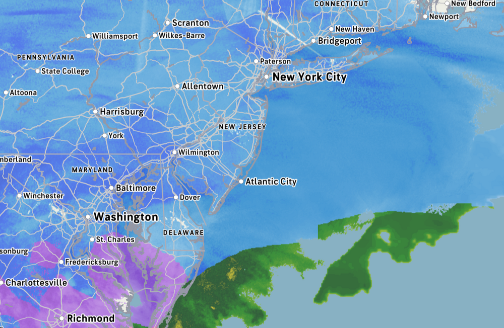
Fairly accurate depiction of the snow / sleet / mix
-
Steady Eddie snow up to 3.5 here (Monroe,NJ)
-
11 / 8 - snow (about 2.9 on the ground). Cold / snow / mix later. Cold - frigid week with overall cold below - much below avg. Some moderation between 2/3 - 2/6 before cold returns. If the 1994 like pattern continues - would expect another bout of snow/ice in the next 7-9 days.
-
Mix line between DC/ Baltimore and MD east shore.
-
Thats about the ratio i just estimated. Larger flakes now too
-
trying to reverse engineer my avg snow ratio since it started around 4:30 AM. 0.11 LE - 2.3 inches of snow = about a 20:1 ratio currently
-
Even Atl dealing with the frozen part of this earlier this morning
-
Always enjoy the tracking and im sure there are still some surprises in store with some jackpots, sleet progression or lack of progression. Been a few years for such a widespread impactful storm. All systems are go.


