SACRUS
-
Posts
15,512 -
Joined
-
Last visited
Content Type
Profiles
Blogs
Forums
American Weather
Media Demo
Store
Gallery
Everything posted by SACRUS
-
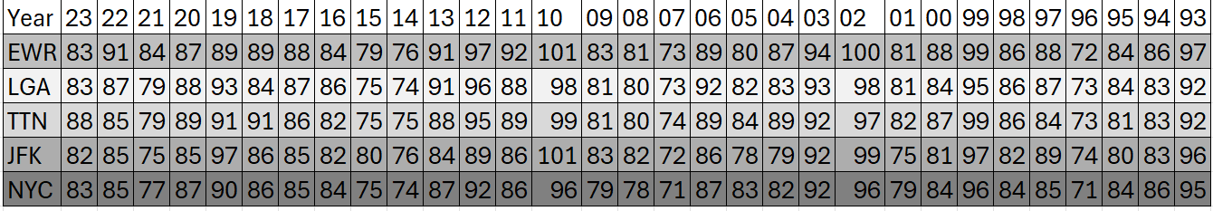
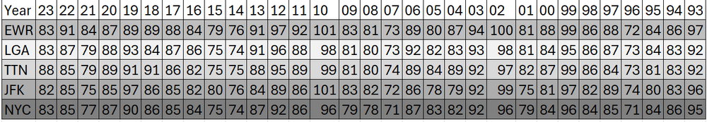
July 4th the past 30 years (highs)
-
Partly cloudy and warm upper 80s to 90s, by the evening a piece of energy is triggering storms to the west and north, perhaps some scttered / isolated showers into the evening - not ideal but looks overall 85%- 90% like a great fourth. Good luck and enjoy.
-
Sharp contrast between the 23 / 24 Junes. Keep the SI stats coming - perhaps a happy median from the NYC / EWR readings.
-
Ridge west/ trugh MW, ridging into the east coast. Warm/humid with more chances for rain/ wetter
-
74 / 54 sunny and another gem on tap. Low - Mid 80s, warmer spits to the upper 80s. A bit warmer tomorrow s ridge builds in mid / upper 80s, perhaps a stray 90 in the warmer spots. $th of July mainly dry but some scattered storms later in the evening. Ridge west, trough into the MW, and Western Atlantic Ridge keeping heights elevated along the East coast with a humid southerly/SW flow. Overall warm - hot with chances for storms and increased rainfall. Cut off low under the Atlantics ridge meander offshore. Hotter day Sun (7/7). Clouds will limit heat when storms fire but chances of near/low 90s in the period. 7/1 - 7/3 : Dry, warm near normal 7/4 - 7/11: Warm - hot, humid - storms almost daily 7/12 - beyond : Overall warm, could see piece of western heat eject east
-
Records: Highs: EWR: 100 (1963) NYC: 100 (1901) LGA: 97 (2018) JFK: 102 (1963) Lows: EWR: 52 (1943) NYC: 52 (1943) LGA: 56 (1988) JFK: 56 (1988) Historical: 1792 - A tremendous storm (a tornado or hurricane) hit Philadelphia and New York City. Many young people were drowned while out boating on that Sunday. (David Ludlum) 1911 - The high of just 79 degrees at Phoenix AZ was their coolest daily maximum of record for the month of July. The normal daily high for July 1st is 105 degrees. (The Weather Channel) 1979 - It snowed almost half a foot (5.8 inches) at Stampede Pass WA, a July record. (The Weather Channel) 1987 - Lake Charles LA was drenched with a month's worth of rain during the early morning. More than five inches of rain soaked the city, including 2.68 inches in one hour. A thunderstorm in the southern Yakima Valley of Washington State produced high winds which downed trees up to six feet in diameter. (Storm Data) (The National Weather Summary) 1988 - Twenty-six cities in the north central and northeastern U.S. reported record low temperatures for the date. Lows of 48 degrees at Providence RI, 48 degrees at Roanoke VA, 49 degrees at Stratford CT, and 48 degrees at Wilmington, DE, were records for the month of July. Boston MA equalled their record for July with a low of 50 degrees. Five inches of snow whitened Mount Washington NH. (The National Weather Summary) 1989 - Showers and thunderstorms associated with the low pressure system which was once Tropical Storm Allison continued to drench parts of Mississippi, Louisiana and eastern Texas. Late night thunderstorms produced 12.58 inches of rain at Biloxi, MS, in six hours, and 10.73 inches at Gulfport MS. Flooding in Mississippi over the first six days of the month caused 55 million dollars damage. (The National Weather Summary) (Storm Data) 2002: San Antonio, Texas recorded 9.52 inches of rain on this day to set a new record for its greatest rainfall for the entire month of July.
-
Highs: EWR: 84 ACY: 84 New Brnswck: 82 JFK: 82 PHL: 82 BLM: 81 ISP: 81 NYC: 81 TTN: 81 TEB: 80 LGA: 79
-
Think the 10th was a 0 departure they may lump in as a (-) I have 4 (missed the -1 on the 12th.)
-
Only 3 below average daily avg at EWR in June, the rest at or above normal
-
Great stats, Don thanks for sharing. 8 90 degree days?
-
Monthly rain: EWR: 1.75 EWR: 1.71 LFA: 1.67 TTN: 1.44 JFK: 2.95
-
Thnks, Don - Can you post your top 5 June ?
-
Jun Dep: EWR: 77.5 / +4.7 LGA: 76.1 / + 2.7 NYC: 75 / +2.9 JFK: 73.8 / +3.5
-
Current progression of 7 days - believe those increase with storms over the weekend. MW continues the soaking.
-
71/ 56 and sunny. Great stretch of weather the next 72 hours, low to mid 80s, mostly sunny / partly cloudy and low humidity. Ridge builds back in by Wed - warming up. Fourth looks mainly dry and scattered storms later - think its more isolated/ Could be cloudy, otherwise near/ low 90s. Ridging along the east coast keeps a more warm-hot / humid flow from Fri (7/5) into the coming extended weekend and next week - When its not cloudy, it heats up quickly, but chances for rain . 18 - >20C by Fri and the weekend would make 90s easy with sunshine Later next week more humid southerly flow keeps it overall warm but continued storms chances. 7/1 - 7/3 : Dry and gorgeous stretch 7/4 - 7/8 : Hot, Humid - storms chances - when sunny heats up quick (potential heatwave) 7/0 - beyond : Overall warm - humid and rain chances - tropics could enhance mid month
-
Rainfall here 1.54 New Brnswck: 1.62 JFK: 0.54 EWR: 0.40 NYC: 0.18 LGA: 0.12
-
Records: Highs: EWR: 103 (2021) NYC: 99 (1964) LGA: 100 (2021) JFK: 99 (1964) Lows: EWR: 55 (1940) NYC: 53 (1919) LGA: 57 (1996) JFK: 56 (1988) Historical: 1886 - The second destructive hurricane in nine days hit the Apalachicola-Tallahassee area. (David Ludlum) 1900: The combination of high winds and the presence of wooded fuel-filled cargo helped to spread fire on the Hoboken Docks in New Jersey. The fire began when cotton bales caught fire and spread to nearby volatile liquids. The fire killed at least 300 people and was seen in New York City. 1942 - The temperature at Portland, OR, hit 102 degrees, an all-time record for that location. (The Weather Channel) 1972 - The entire state of Pennsylvania was declared a disaster area as a result of the catastrophic flooding caused by Hurricane Agnes, which claimed 48 lives, and caused 2.1 billion dollars damage. (The Weather Channel) 1987 - Hot weather prevailed in the Pacific Northwest, with readings above 100 degrees reported as far north as southern British Columbia. Yakima, WA, reported a record high of 100 degrees, while temperatures near the Washington coast hovered near 60 degrees all day. Thunderstorms prevailed from southwest Texas to New England. Thunderstorm winds gusting to 100 mph at Gettysburg, PA, killed one person. High winds and large hail caused more than five million dollars damage to property and crops in Lancaster County, PA. (The National Weather Summary) (Storm Data) 1988 - Thunderstorms in eastern Kansas drenched Worden with 12.21 inches of rain, and a wall of water two to four feet deep swept through Lone Star, KS, flooding every home in the town. Up to ten inches of rain was reported southeast of Callaway, NE. Thunderstorm winds gusted to 75 mph at Winfield, KS. Seventeen cities in the north central and northeastern U.S. reported record low temperatures for the date, including Duluth, MN, with a reading of 36 degrees. (The National Weather Summary) (Storm Data) 1989 - Winnfield, LA, reported 22.52 inches of rain in three days, and more than thirty inches for the month, a record for June. Shreveport LA received a record 17.11 inches in June, with a total for the first six months of the year of 45.55 inches. Thunderstorms also helped produce record rainfall totals for the month of June of 13.12 inches at Birmingham AL, 14.66 inches at Oklahoma City, OK, 17.41 inches at Tallahassee FL, 9.97 inches at Lynchburg, VA, and more than 10.25 inches at Pittsburgh, PA. Pittsburgh had also experienced a record wet month of May. (The National Weather Summary) 1999: Mount Baker, Washington closed out a record snowfall season both for the United States and the verifiable world record as the seasonal total from July 1, 1998, to June 30, 1999, finished with 1,140 inches.
-
Highs: EWR: 91 PHL: 90 TTN: 88 TEB: 88 LGA: 88 (* erroneous reading of 100.9) New Brnswck: 87 ACY: 86 NYC: 85 BLM: 86 JFK: 83 ISP: 83
-
To 89 here on a late high doged the rain so far or a majority of it. EWR to 90
-
87 / 75 Storms riding 80 and sagging /extending south. More storms into NE PA pusing in from the west
-
85 / 75 some breaks in the clouds, storms firing north NJ - HVlley , CT. More sun by 2;30 - 4:00
-
80 / 74
-
Ridge west / W. Atlantic ridge pumping heights along the coast trough/ more rain in the MW