SACRUS
-
Posts
13,176 -
Joined
-
Last visited
Content Type
Profiles
Blogs
Forums
American Weather
Media Demo
Store
Gallery
Everything posted by SACRUS
-
83/ 73 - hazy and partly cloudy. Some clouds and spotty showers around. Only clouds would impact a 100 degree readings in the area. Some showers possible overnight, trough pushes through a brief 18 hour drier / cooler period that may break the heatwave in the warmer spots with mid - upper 80 degree readings (oasis in a sea of heat / humidity). Heat returns Tue (6/25) - Thu (6/27) with surge of >20c 850 MB temps Wed into Thu. The race to 100 on Thu will be close between storm/clouds on the approaching front. Cooler later Thu and Fri (6/28) before ridging and more heat push into the area next weekend to close the month hot and humid. Overall ridging into the east, hot and humid and perhaps more chances for storms riding the periphery of the ridge fluctuating between the humid southerly and brief northwest flow. 6/17 - 6/27: Hot (oasis of cooler 6/24) 6/27 - 6/28: Cooler 6/29 - beyond : hot, humid
-
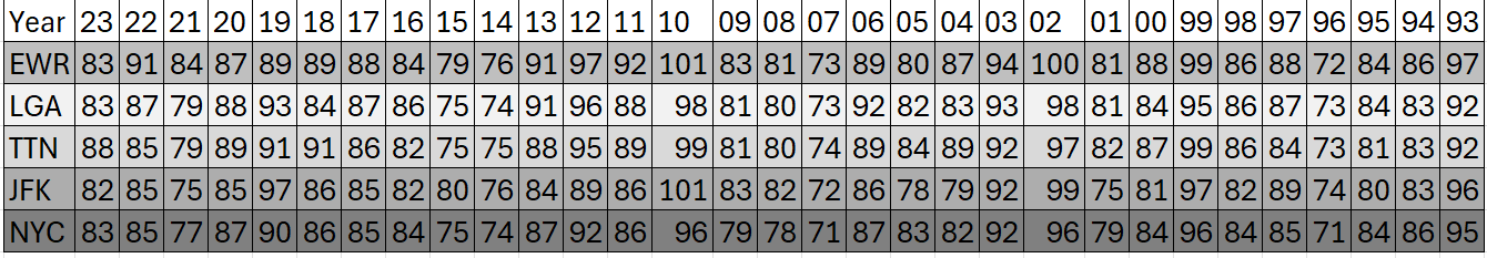
Records: Highs: EWR: 101 (1988) NYC: 98 (1988) LGA: 99 (1988) JFK: 94 (2012) Lows: EWR: 48 (1940) NYC: 52 (1940) LGA: 53 (192) JFK: 55 (1992) Historical: 1928: A farmer near Greensburg, KS looked up into the heart of a tornado. He described its walls as "rotating clouds lit with constant flashes of lightning and a strong gassy odor with a screaming, hissing sound." 1947 - Twelve inches of rain fell in forty-two minutes at Holt, MO, establishing a world rainfall record. That record was tied on January 24-25, 1956, at the Kilauea Sugar Plantation in Hawaii, as their state record was established with 38 inches of rain in 24 hours. (The Weather Channel) 1972 - Hurricane Agnes deluged Pennsylvania and New York State with torrential rains resulting in the most costly flood in U.S. history. In the Middle Susquehanna Valley of Pennsylvania, 24 hour rainfall amounts were generally 8 to 12 inches, with up to 19 inches in extreme southwestern Schuylkill County. At Wilkes-Barre, PA, the dike was breached destroying much of the town. Flooding resulted in 117 deaths and 3.1 billion dollars damage. (David Ludlum) 1981 - A young woman from Lubbock, TX, was struck by lightning. The bolt of lightning struck just above her right shoulder near her neck, and passed right to left through her body, tearing her warm-ups, causing her tennis shoes to explode, and lifting her two feet into the air. (The Weather Channel) 1987 - Thunderstorms in southern Texas produced wind gusts to 116 mph near Quemado. Thunderstorms in New York State produced 5.01 inches of rain in 24 hours at Buffalo, an all-time record for that location, and produced an inch of rain at Bath, PA. The temperature at Fairbanks AK soared to 92 degrees, establishing a record for the date. (The National Weather Summary) (Storm Data) 1988 - Sixty-five cities in twenty-four states reported record high temperatures for the date. Tucson AZ reported an all-time record high of 114 degrees, surpassing the previous record of 112 degrees established a day earlier. Highs of 98 degrees at Pittsburgh, PA, and 100 degrees at Baltimore, MD, tied records for the month of June. (The National Weather Summary) 1989 - Record cold temperatures were reported in the High Plains Region. Rapid City, SD, reported a record low of 39 degrees, in sharp contrast to their record high of 102 degrees two days earlier, on the 20th. (The National Weather Summary) 2003: A hailstone measuring 7.0 inches in diameter with a circumference of 18.75 inches and weighing 1.33 pounds falls in Aurora, Nebraska. The National Weather Service reports this is the second largest hailstone ever documented in the U.S. by weight, and the largest by size at that time. The world's largest hailstone NOW was produced from storms in South Dakota; 8" in diameter and 1.9375 lbs. on July 23, 2010. kl
-
Highs New Brnswck: 98 ACY: 98 PHL: 98 TTN: 98 BLM: 97 EWR: 95 TEB: 95 LGA: 94 NYC: 93 JFK: 87 ISP: 85
-
Highs New Brnswck: 98 ACY: 98 PHL: 98 TTN: 98 BLM: 97 EWR: 95 TEB: 95 LGA: 94 NYC: 93 JFK: 87 ISP: 85
-
-
Central park did break 90 (91) for the park's first heatwave
-
96/ 71 here. Clouds to the north but looks to clear behind the storms that have developed. we'll see how more pop up.
-
93 / 73 quite humid. Wind: 193° (SSW)
-
NW- NJ storms
-
90 / 71 here Wind:D 233° (SW)
-
Close the month with more ridging into the east. More NW flow to open next month - warm.
-
82 / 71 - sunny and on the way to another 90+. Mid/upper 90s with enough sun. Showers and storms later pop-u, models have them in the same northern sections of etreme N-NJ, Husdon Valley,CT - we'll see if they are more south than last night, otherwise hot and humid. Later tonight and tomorrow >20C 850 MB temp come in and through on a SW flow. Only clouds, shower/storms or debris clouds would spoil 100 degree readings in the warmer spots. Trough pushing front through Mon (6/24), but still warm upper 80s to low 90s in the warm spots to extend the heat,with continues threat of shower/storms. Tue (6/25) drier and again upper80s / low 90s in the warmer spots. Brief surge of stronger heat Wed (6/26) >18c 850 MB temps and if dryness persists the next shot at 100's in the warmer spots. By Thu (6/28) - Fri (6/29) brief push of cooler air to break the heat before ridging into next weekend by the 30th. Overall warm - hot the next 7 - 10 days and beyond. 6/17 - 6/26 : Hot/humid 6/27 - 6/28: Brief cooldown 6/29 - beyond : warmer/ (more 90s potential)
-
Additional storms into NPA-N NJ
-
General forecast on the major medium/long range is for a hot/humid Jul 4th. Ridging rebuilds towards the first and it looks hot leading into the 4th and the extended weekend. WIll need to watch storms under aamore humid flow and the ridge periphery.
-
Records: Highs: EWR: 100 (2024) NYC: 97 (1988) LGA: 98 (2012) JFK: 97 (2012) Lows: EWR: 46 (1940) NYC: 49 (1897) LGA: 53 (1940) JFK: 56 (1968) Historical: 1893 - On the first day of summer the temperature at Dodge City, KS, soared to 106 degrees during the midst of a blistering heat wave. The heat wave initiated a severe three year drought in the Central Plains Region. Ironically, at about the same time, heavy rains in the Mississippi Valley were causing the river to swell to its highest level of record at New Orleans, LA. (David Ludlum) (The Weather Channel) 1919 - Seven heavy coach cars of a moving train were picked up and thrown from the tracks by tornado winds. A baggage car was set down thirty feet away from the rest of the train. (The Weather Channel) 1954 - A severe hailstorm struck Wichita KS and vicinity causing nine million dollars damage. (The Weather Channel) 1972 - Phoenix, AZ, was drenched with 1.64 inches of rain late on the 21st and early on the 22nd to easily surpass their previous June rainfall record of 0.95 inches. The total for the month was 1.70 inches. (The Weather Channel) 1987 - A tornado destroyed 57 mobile homes at the Chateam Estates trailer park northwest of Detroit, MI, killing one person and injuring six others. Total damage was estimated at 1.7 million dollars. Thunderstorms over Lower Michigan also drenched the Saginaw Valley with up to 4.5 inches of rain in less than six hours. (The National Weather Summary) (Storm Data) 1988 - The first full day of summer was a torrid one, with afternoon highs of 100 degrees or above reported from the Northern and Central Plains to the Ohio Valley. Sixty-nine cities in the north central U.S. reported record high temperatures for the date. The high of 110 degrees at Sioux Falls, SD, was an all-time record for that location. Highs of 103 degrees at Des Moines, IA, 102 degrees at Fort Wayne, IN, 109 degrees at Huron, SD, 108 degrees at Sioux City, IA, and 101 degrees at South Bend IN were records for June. (The National Weather Summary) 1989 - The first day of summer heralded snow in the northern and central Rockies. In Colorado, 15 inches of snow was reported at the summit of Mount Evans and, in Wyoming, 18 inches was reported at Dickensen Park, west of Lander. Heavy rain continued in the eastern U.S. Huntsville, AL, reported a record 11.65 inches for the month, compared to the 0.17 inch rainfall total in June 1988. (The National Weather Summary) (Storm Data) 2005 - A slow-moving thunderstorm dumped up to a foot of hail in southeastern portions of Colorado Springs, Colorado. Snowplows had to be used to clear a route through a major thoroughfare in the city. Heavy rainfall from the storm left up to 4 feet of water in city streets, trapping dozens of motorists (Associated Press).
-
Highs: EWR: 100 LGA: 97 BLM: 96 TEB: 96 New Brnswck: 95 ACY: 94 NYC: 94 TTN: 94 PHL: 94 JFK: 91 ISP: 88
-
Highs: EWR: 100 LGA: 97 BLM: 96 TEB: 96 New Brnswck: 95 ACY: 94 NYC: 94 TTN: 94 PHL: 94 JFK: 91 ISP: 88
-
https://synoptic.envsci.rutgers.edu/img/vis_nj_anim.gif
-
-
98 / 67 here
-
89/68 here at 11AM Wind : 221° (SW)direction
-
Current Global SST anomaly
-
July 4th coming into range and most guidance showing ridging into the east SW/SSW flow - warm/humid for the period.
-
81 / 67 and sunny SW flow. Off to the proverbial races temp-wise mid - upper 90s, recent dryness enhancing heating. Storms fire north each of the next two nights and we'll see if any get or make their way down to North Jersey. Heat is on through Sunday and only scattered showers storms, clouds or debris clouds from northern storms would limit the heat. Trough pushes first meaningful front through on Mon but still remaining hot and with enough sun another day of the heatwave. Tue dries out and bit cooler but warm spots should touch 90. A quick surge of hotter by Wed (6/26) before the next trough moves in with cooler period for 2 days. Ridgiing and warmth building back to close the month on the 30th and setting up the next hot period / heatwave. 6/17 -6/26 : Hot 6/27 - 6/29: brief cooldown 6/30 - beyond : hotter/ humid
-
Clouds or shower, pop up storms only issue for higher on Sat / Sun,most model keep the bulk of the activity north but we'll see. Surge of >20C 850 MB temperatures late Saturday and Sunday.