
djr5001
-
Posts
1,922 -
Joined
-
Last visited
Content Type
Profiles
Blogs
Forums
American Weather
Media Demo
Store
Gallery
Posts posted by djr5001
-
-
3 minutes ago, canderson said:
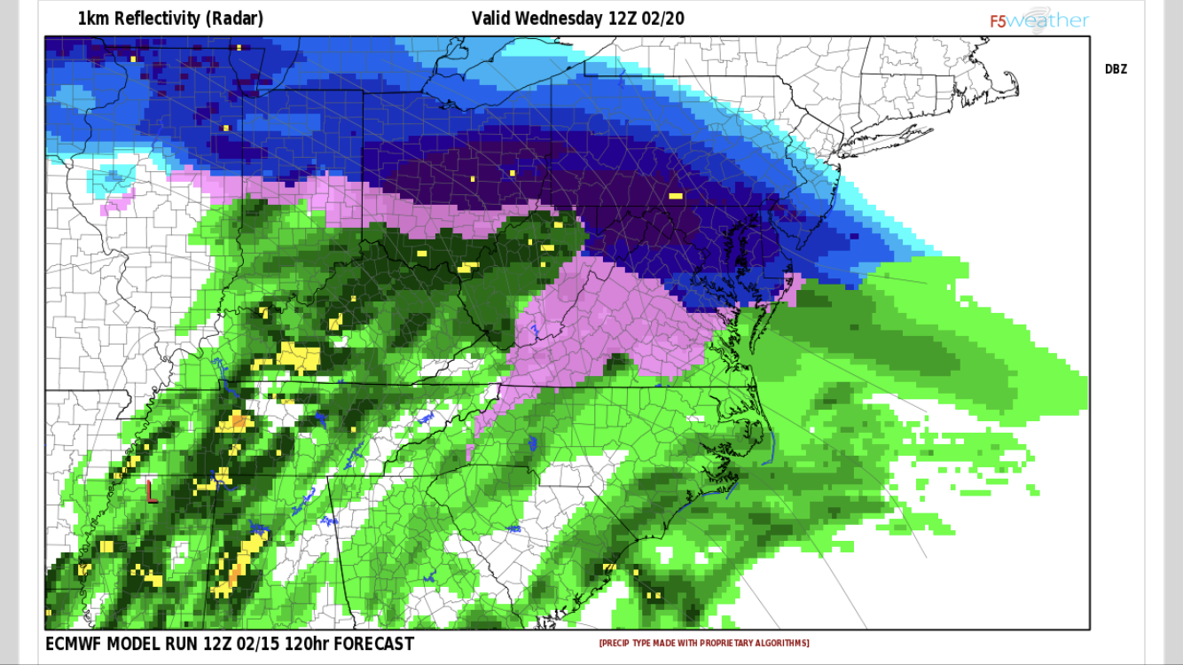
Euro looks to be a 3-6” storm for basically the entire subforum. Gets heavier the more W/SWyou go. MDT around 4” or so I’d guess. Laurels and MAG highest.
This run is slower to push the early heavier precip our way and pushes the warm air aloft in faster so we changeover earlier in the afternoon. A couple inches whether it ends up being 2” or 6”+ then ice is going to be messy regardless. The cold will hold at the surface but no way it holds aloft - much like last week’s event. Our high for Thursday is currently 47 - fresh snow and ice is not going to let it reach that. NWS doesn’t seem to have much confidence in how much precip the NAM drops across southern PA in a short period of time. They also seem to be holding off on any watches because of the GFS/GEFS/SREFs
-
 1
1
-
-
With a quick look - 0z Euro looks to be fairly similar to 12z with a slightly quicker northward push of warmer air Wednesday afternoon so just south of Mason Dixon Line sees earlier changeover. Unfortunately what I have access to I cannot post maps so someone else will need to as usual.
-
1 hour ago, canderson said:
GFS appears to be a VA special.
Precip just doesn’t push into PA as much as NAM has been doing. It appears as if around 750mb will be the layer to watch with the warm air push aloft according to most of the models Wednesday afternoon. Models including afternoon and early evening runs of HRRR today have not handled this system tonight well at all across much of PA. The precip has ended several hours early with not much falling at all for a number of locations it seems.
-
2 minutes ago, bubbler86 said:
Quick ob...light rain and 34 in Gettysburg
Same here west shore Harrisburg. Based on surface dew points, as the air near the surface cools I imagine sleet will at least mix in if not take over fairly quickly for the next few hours
-
49 minutes ago, paweather5 said:
All models look better for Wednesday. Euro looks good.
This 12z Euro run looks somewhat close to a repeat of this past week (not referring to setup/pattern but how event plays out p-type wise). Initial snowfall across LSV and some into central and NE PA while SW PA gets torched + rain before warm air aloft wins out with colder temps near the surface for the transition of snow to ice. Critical thicknesses again not on a favorable side with the warm air push aloft but temps just cold enough for accumulations. If only we can get a few runs to show this now and maybe get timing about 6 hours or so earlier so initial snow falls overnight I would say there is at least a chance! Just a week later but peak sun angle next week is almost 3 degrees higher and length of day 20 minutes longer - equivalent to October 21 - which starts to matter here soon in fringe temperature situations in adding a little melting to the accumulating snow during the daytime hours.
-
 1
1
-
-
1 hour ago, canderson said:
... back to the weather.
At a quick glance it appears the 12z models lost basically every snowmaker potential for the next week. Cutters but I don't see any cold air to help it not rain.
12z run of the euro has us (LSV) with our best chance for snow Tuesday night into early Wednesday but even that run verbatim the vertical profile is a degree or two too warm for snow and then wants to develop a southeast ridge late next week behind that system that would likely keep temps at or above normal here through next weekend.
-
Never had that “warm up” overnight that was expected with the front - Temp stayed 32-33F all night here.
-
14 minutes ago, sauss06 said:
are you at work or over home? I'm at work on Crooked hill, we're still below freezing at 31
I'm hearing roads suck
Home - plow truck comes through with salt and road clears then slowly freezes back over. Outdoor thermometer is reading 34F but nothing is noticeably melting other than what I can hear coming off the roof. It looks like cars on I-81 are moving fine but keep hearing occasional sirens for an accident somewhere.
-
1
-
-
Snow is caked to trees/lines/etc still here - if those wind gusts across western pa end up similar here it could cause a few problems
-
3 minutes ago, pawatch said:
1.5" and appears to be some freezing stuff.
NWS really dropped totals.

Yea its for 7am to 7pm today and those 2” totals are just not going to happen. Williamsport is already on the doorstep of the mixing line if it hasn’t already started to changeover there based on radar and mping obs
-
42 minutes ago, sauss06 said:
Its just been mostly rain since i left for work at 530. i'm still at 29 degrees
@djr5001 what is your total?
Measured about 4.4” depth but the rain is already starting to impact that. This snow did stick to trees/etc well so hoping the rain knocks it off rather than making it heavier on the limbs. Models didn’t do a terrible job at all - just held onto the colder air longer to have longer period of sleet than what is occurring.
-
1
-
-
Radar returns are going to look like the precip is dropping off as it moves from what is falling as rain/mix to the snow here east of the mountains so I’m guessing that is what is making it look like its drying up.
@canderson how much is in the city? I am back up to 4” and somehow must be doing better than both you and Carlisle
Just now, Blizzard of 93 said:I am really not sure what you guys are looking at now?
The Radar looks good & is filling in nicely.
Every reporting station from I-80 to the south is reporting some type of precip. It is supposed to snow in the Harrisburg area until at least 6 am. I think we get a few more inches of snow before the mixing begins.
-
22 minutes ago, Cashtown_Coop said:
This is for Adams:
WHAT...Snow then heavy mixed precipitation. Additional snow
  accumulations of 3 to 4 inches and ice accumulations of up to
  one half of an inch are expected.
20 minutes ago, pasnownut said:add York and Lancaster as well.
FYI - counties were wrong in the alerts that went out a half hour ago. Adams/York/Lancaster have been corrected to 3-4” and .1-.2” ice not .5”
-
13 minutes ago, sauss06 said:
I just got an alert that Cumberland is under a warning too
Yea they are continuing the warning - likely pushed alerts because they messed up the counties yet again today and had York/Lancaster with a half inch ice instead of Johnstown/Altoona
-
1
-
-
://twitter.com/NWSStateCollege/status/1095025865572974592
-
13 minutes ago, sauss06 said:
i can't pull a radar up at work, when do you see us picking up again?
Based on radar trends I believe we should at least start to see flurries again here in the next hour or so
-
There are several 3.5"+ obs north of Baltimore where it is trying to changeover but heavier rates appear to keep turning p-type back to mostly snow for now. @Cashtown_Coop looks to be in a really nice spot at the moment for this afternoon.
-
10 minutes ago, canderson said:
Tomorrow looks more and more icey than snowy for us the LSV. Boooooooo. I am not sure if we can pull 5" out of this system with the rushing warmth that I didn't think would occur but it's legit apparently.
Not so sure we see much in the way of ice with surface temps hanging around 30-32F. Closer to MAG is where the ice issues are more likely. Tomorrow's length of day and peak sun angle is equivalent to October 29th combined with the transition to rain with warmth aloft so not sure we have issues other than some crust forming early in the day on where snow has not been cleared. To me this looks a lot like that storm we had back in January where we hold the transition off just long enough with good rates in the last hour or two before changeover before sunrise that we get into that 4-6" total area before torching to rain during the day. There is a lot of moisture moving in so with this system and much more than what was available with that January event so with the right dynamics its possible but yea the warmth will win eventually.
-
9 minutes ago, CarlislePaWx said:
Morning all...
Looks like I've got 1.7" total on the board for the storm 1 event. Had 0.8" at midnight followed by another 0.9" up to the present. It is still snowing very lightly, not enough to accumulate, but it still looks pretty against the woods backdrop of my backyard along with the birds.
Well, no warning, which seems a bit odd given that the criteria for a warning is 5"+ in 12 hours or 8"+ in 24 hours. I think they're gun-shy from the previous bust. Time will tell. The radar looks like Franklin, Adams, York, and Lanco counties are getting hit pretty good right now from early storm 2.
LWX may need to bump up totals for their northern tier ahead of the changeover - right now only have 1-2" for Hagerstown/Westminster/Bel Air with some 2" reports already starting to show up. A good bit of moisture overhead for the main event so far to the south and west!
-
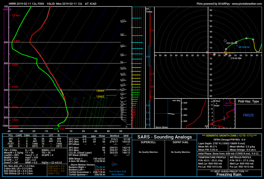
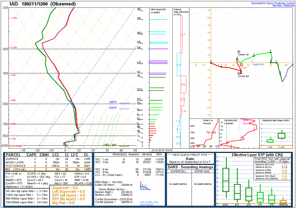
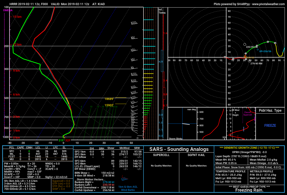
Now that we have the 7am sounding data available - I was checking some model data for 7am vs the observed sounding data for a few sites south and west (with 12z HRRR vs observed as an example below for Dulles). Other than 12z NAM finally noticing it - several recent model runs had the leading edge of the warm layer around 925mb a little further south than what the observed data is showing. Could mean absolutely nothing over central PA for now but worth watching as p-type reports show up later around Mason-Dixon Line. Current changeover line looks to be running from Frederick to Baltimore along I-70. While the cold air may barely hang on at the surface it sure is going to get warm aloft during the day tomorrow at least across southern PA.
-
2
-
-
3 minutes ago, CarlislePaWx said:
Well, one thing is very interesting and that is the 3km NAM keeps MDT at or below 0 (surface) until 3Z Wed and by then it shows the precip has ended, implying little to no actual liquid rain falls.
Looking at the sounding for MDT the warm layer ends up around 800mb which pushes in around 4-7am Tuesday on this run before 750-850mb layer warms quite a bit by the afternoon. If surface temps stay at or below freezing until 3z Wednesday that will be sleet Tuesday morning to freezing rain by Tuesday afternoon
-
56 minutes ago, CarlislePaWx said:
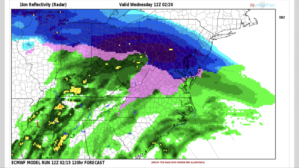
FV3 most bullish of NAM/GFS models for Friday with 2-3" in our area. Other 3 are 1" or less. Wonder how long it will hold on to this 2/8 storm? After the Euro comes out maybe someone with access can tell us if that storm is showing up on it?
Euro has a low pressure system around 2/7-2/8 but there is no digging so it tracks well to our north and west. Euro is actually pretty dry for LSV for the next week leading up to that system. 12z run has Harrisburg reaching 67F on Tuesday lol.
-
3 hours ago, sauss06 said:
Djr is that all you recorded? At 530 when we went out to shovel, my brother I law who lives next store said he just measured 3.5, I didn’t measure because he did.
@bubbler86 it laid on our streets, they came through and plowed. I had more on my driveway and sidewalks though.
10 degrees this morning. I’m assuming the wind kept it from going lower.
2.4" is the max I recorded - could very well have been my south facing hillside climate that with such little liquid content I had some minor melting occurring during the afternoon while it was falling that I just never found a spot with more.
-
1
-
-
Just measured 1.3” on my board and driveway has maybe .3” (northern Enola) - there is not much moisture in these flakes at all so ratios could very well be close to 20:1. Radar looks great but other than a period of larger flakes earlier it is really not coming down the way radar makes it look like it should be.


Central PA - Jan/Feb 2019 Obs and Discussion
in Upstate New York/Pennsylvania
Posted
Somerset-Johnstown-Altoona-Chambersburg 3-5” with localized 7” and with 0.1-0.2” ice
Harrisburg - Hershey - Carlisle - York - Lancaster and surrounding area 3-5” with up to 0.25” ice
@Voyager ‘s Schuylkill snow hole - 2-4” and up to 0.25” ice
edit - sorry accidentally deleted that this was from the WSW text