
djr5001
-
Posts
1,922 -
Joined
-
Last visited
Content Type
Profiles
Blogs
Forums
American Weather
Media Demo
Store
Gallery
Posts posted by djr5001
-
-
HIA reporting 0.25” ice, York at 0.17”, Lancaster 0.20”, Johnstown 0.21”, Williamsport 0.16”, Altoona 0.12”
-
 1
1
-
-
7 minutes ago, Ruin said:
hmm so as soon as it starts back up I go from 29-32 out of no where. hope heavy bands can knock it down to 29 and snow. but i doubt it. something fishy is going on heh
It’s too warm aloft for any snow now around here - we are pretty much down to freezing rain
-
1
-
-
Just now, pasnownut said:
Hrrrrrrr and nammmm both have a nice slug of zr headed this way.
Gonna b Schlippy.
It’s this period of lighter precip that is going to be the biggest issue for a while because its going to cause accretion faster than heavier rainfall rates and heavier rates right now would likely flip the droplets to sleet with the low level (850mb to 925mb to 1000mb) still quite cold. So yea giving accretion a head start before more moisture later that both of those are showing is going to make it quite icy especially now that the sun is approaching sunset too.
-
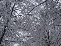
Still light drizzle here (between @sauss06 and @Blizzard of 93) and its freezing on everything - measured close to 0.10” on a cold surface. I need to find or set something up for better measurement later. Had max depth of 5” and melting down now to see liquid content which I should have done a few hours ago as the snow let up. Current depth now that there is a layer of ice is closer to 4.5”.
-
11 minutes ago, bubbler86 said:
I was, thanks. I am going through that "whats next" phase right now. The Euro on weather.us is a lot slower than the paid folks get it.
It really didn’t pick up this event until after last week’s so the possibility definitely isn’t dead and certainly could come back. Sometimes it just seems in active patterns that there is too much going on ahead of potential events that the models struggle until one or two move through and are out of the way.
-
1
-
-
24 minutes ago, bubbler86 said:
Do you have the capability to peek at the Euro for 7 days from now?
12z run today did not bring back the storm from yesterday’s 12z if that is what you are asking about
-
Just measured 5.0” at home @sauss06 - precip is light now but has changed to a light sleet/rain mix
-
1
-
-
Blue is 1000-850mb and yellow is 850-700mb. Fully expecting these to kick north one by one later with red leading the charge followed by yellow, green, then blue. These really show the torching west of the mountains and CAD east.
-
 1
1
-
-
3 minutes ago, sauss06 said:
How will the speed affect the potential sleet and frzn at the end?
I would imagine it will be more rain than sleet for the second wave later - the dryslot may allow surface temps to slightly warm but there is no way lower levels near surface with fresh snowfall get above freezing until tonight at earliest when the rain arrives with the warmer air. It’s going to be a tough call for Penndot because they often say they like to leave a little bit of snow before a changeover because its easier to remove with the ice on top. Hours of nothing will leave bare but probably salted roads for when the next wave hits.
-
1
-
-
29 minutes ago, Cashtown_Coop said:
I’d like to see the radar backfill a little bit to the west. We may run out of moisture before the column
Its being pushed west to east so fast we are not even going to get that hour or two where we thought we could hold onto snow before the flip. NWS noted movement speed is 60mph which is faster than some summer thunderstorms!
-
7.2” ob in Boswell Somerset Co looks to be the PA leader at the moment
-
-
-
0z Euro cut 1-2” from almost everywhere fwiw - likely due to earlier changeover from the last few runs. With the window so small (4-6 hours) it is really going to come down to how fast does the initial precip erode the dry air, how heavy of rates can we pull through the morning hours, how many extra hours (1? 2?) can heavy rates hold off the inevitable transition to sleet/freezing rain.
-
2 minutes ago, sauss06 said:
is the ice still .4?
currently says 0.1" to 0.2" ice for Harrisburg area
-
1
-
-
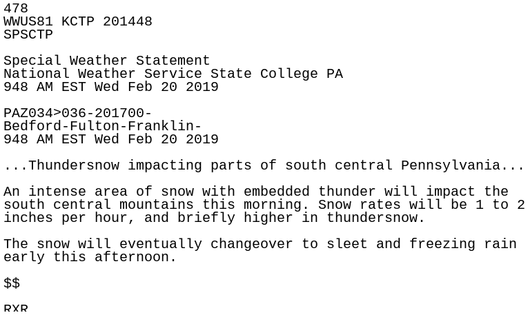
and just like that Winter Storm Warnings have been issued
-
1
-
-
4 minutes ago, bubbler86 said:
I think they have to cancel if there is a WSW and whatever forecaster they use is predicting snow and Ice into that night.
Forecast maps were just updated so I have a feeling the warnings are incoming at any moment now. They now have Carlisle and Lebanon in a 6-8" range with Harrisburg, York, Lancaster, Johnstown, Altoona, State College, Pottsville, and more all at 4-6" plus ice
-
If winds can calm around sunset - tonight is a great example of sites like York airport (KTHV) that will see temperatures drop 5-10 degrees in the hour surrounding sunset (check 5pm and 6pm obs). With dew points this low and starting the night with clear skies (and hopefully calm winds), most of the region should have no trouble seeing temperatures dip into the mid to lower 20s fairly early tonight before the cloud cover arrives ahead of the start of the event. The event last week had us hovering around the low 30s leading into the start of the event, correct?
-
someone needs to post the hr240 euro snowmap for entertainment purposes lol - gives eastern PA 1-2 feet and some spots in NE 2-3 feet
-
Looking at the hourly 12z euro panels - looks like best snowfall is expected from 9am-1pm around @MAG5035 and best for western LSV from 10am-2pm and eastern LSV 11am-3pm before mixing begins to change p-type. What I see from these 12z runs is that the Euro brings the precip further north into PA similar to the NAM but is slower than the NAM to changeover. The GFS is actually slower to warm aloft (occurring later in afternoon similar to Euro) than the NAM but is lacking in the northern into PA precip department until its too late. This 12z euro run verbatim would be probably the best event to include most of this forum that we have seen in a while lol.
-
1
-
1
-
-
1 hour ago, Cashtown_Coop said:
I don’t follow your area that close, did it lock on that idea for consecutive runs or was it a one run wonder?
I think GFS ended up right for the wrong reasons for that one - none of the models handled how far out from center of main system the warm air push was occurring. GFS I believe had a more northern track which was going to allow for rain anyway. The signs were there the day before that warm air was pushing well out and away from center of system so that is one thing I want to watch today - how well models are handling the 700/850/etc layer temps to the south as precip is inching northward.
-
2
-
-
25 minutes ago, canderson said:
Hard to bet against the GFS to me, given it’s stability the past four days and seasonal record.
I think the GFS has been pushing the warm air north too quick for most of our events this winter but the idea of keeping heaviest precip just to our south it is currently not alone. Euro EPS is south of OP and UKMET is with the GFS too and current NWS and NCEP forecasts seem to be favoring GFS/GEFS for some reason. Just feels like NAM is going too crazy with QPF early on in event right now so blend of the two puts @Cashtown_Coop in bullseye again lol.
-
2
-
1
-
-
36 minutes ago, bubbler86 said:
Glad we have another predict. Hated being the only one. I might make a final call tonight after I see 12z Nam's thoughts precip type/how much intrusion of warm air especially down here.
Oops couldn’t get it to paste right so it deleted the start of what my message had when I deleted it but that was from the text for the WSW
-
21 minutes ago, sauss06 said:
serious question as i know you keep records. When was the last time we were to get .25 ice and we got it? seems like a long time ago we had .25 of ice
MDT reported 0.24” back in mid November - the morning of the 16th.
-
1
-
Central PA - Jan/Feb 2019 Obs and Discussion
in Upstate New York/Pennsylvania
Posted
Oh and capital city only reported 0.20” to HIA’s 0.25” lol