

ValpoVike
-
Posts
514 -
Joined
-
Last visited
Content Type
Profiles
Blogs
Forums
American Weather
Media Demo
Store
Gallery
Posts posted by ValpoVike
-
-
About an inch up here so far this evening. It's crazy to be excited about that, but here we are.
-
9 hours ago, Chinook said:
Loveland, Route 34?
It really has been a nice time to get outside and do some walking and jogging, and get going in the morning without having to scrape off a ton of frost or snow. But it does look like winter is coming. Tomorrow, shallow cold front will move in to the I-25 area from the east, and it will stay. The 30-degree cold air mass will be in northeast Colorado for Monday.
Most likely, there will be a significant storm at the end of the week. The models have some consensus that the upper level trough will drop down from the Pac NW on Thursday to Utah on Friday, with significant snow possible for Nevada, Utah, northern Arizona, and western Colorado. As for the Plains, today's models have variable predictions of QPF for Larimer County, SE Wyoming, and western Nebraska. That, is, of course, the main question. It is 6-7 days away, so I guess we won't know yet. This upcoming storm will obviously bring a significant increase in snow cover over 9000 ft.
and here's something you might not want to see

Yep, Hwy 34 on my drive up to Glen Haven. I saw those records on a Facebook post and it is shocking.
-
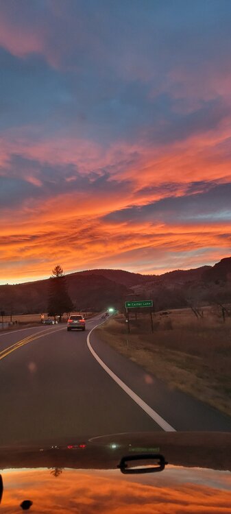
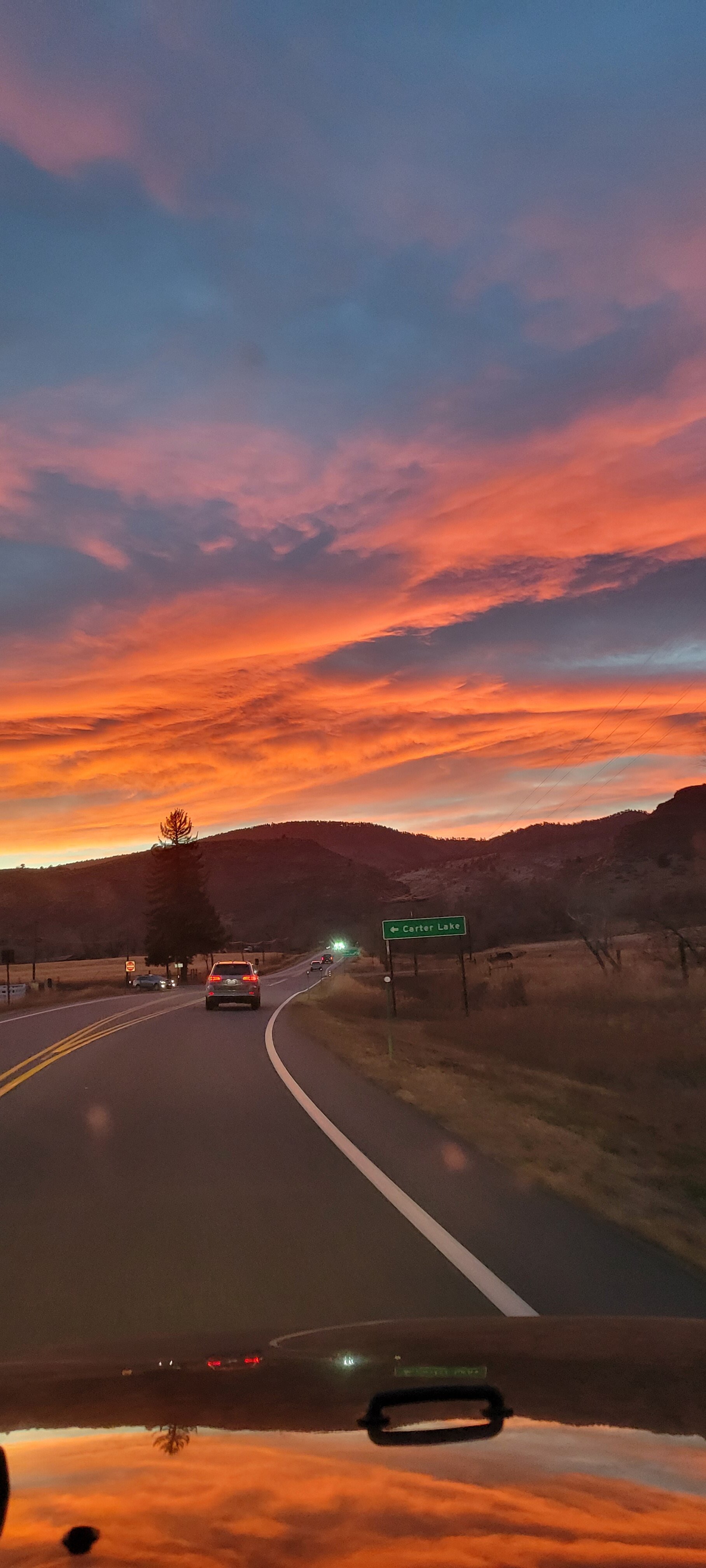
Off topic, but what a sunset this evening along the front range. I captured this photo on my way back home from the airport today. After 7 long days away, the mountains were a welcome sight.
-
 1
1
-
-
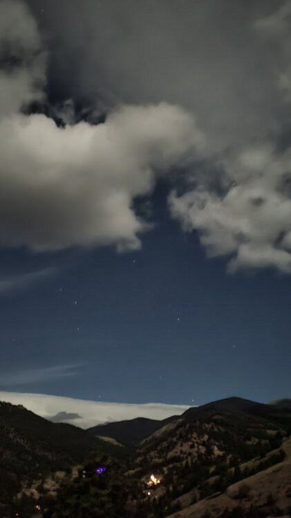
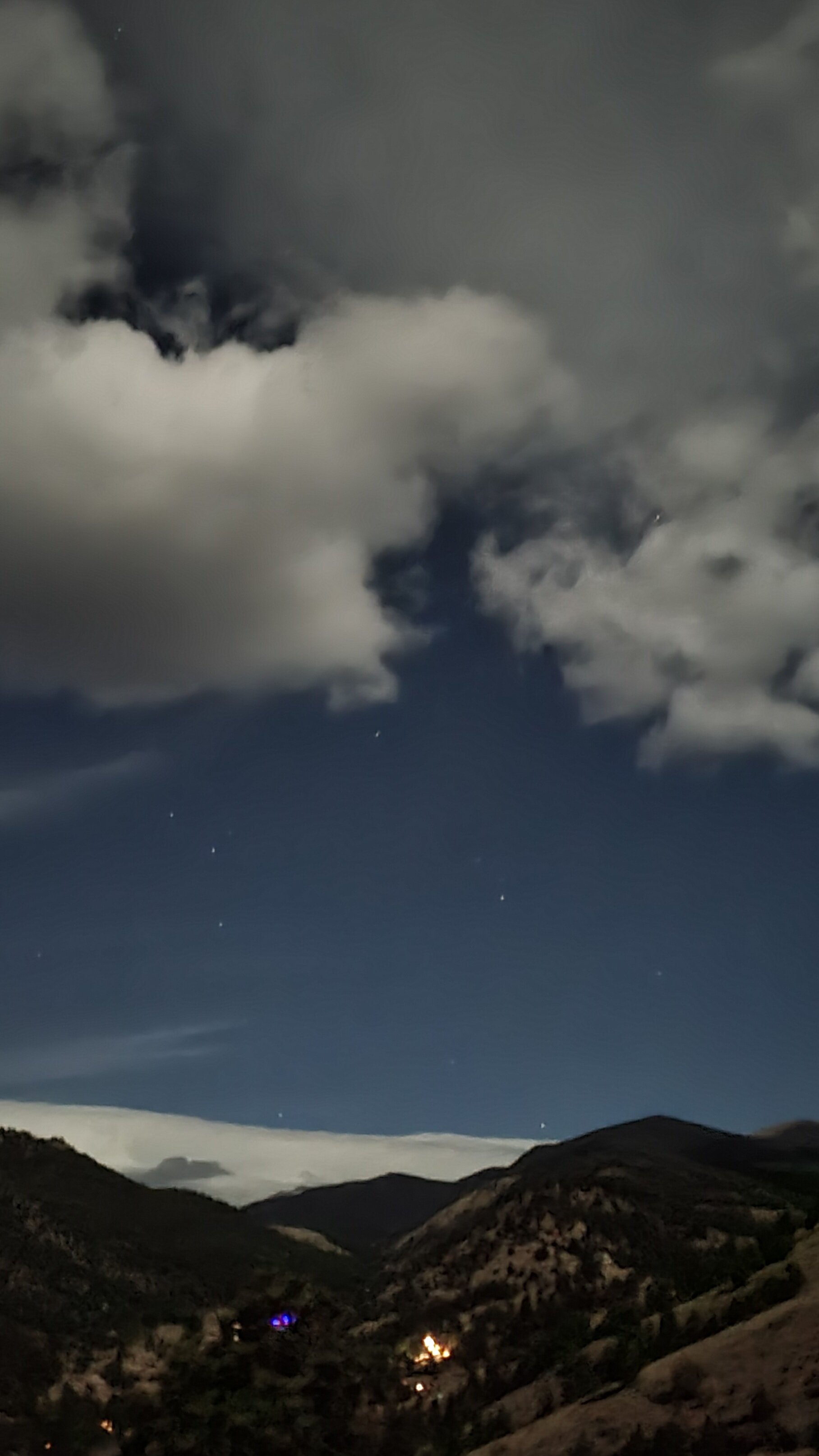
Tonight a weak mountain wave has developed overhead and has been reforming continuously. The full moon makes it an even more amazing sight.
-
3 hours ago, Iceresistance said:
Or if it develops consistency, like what it did in February 2021
Or super overcooked right up to the final days....like what it did last spring in the 90"+ storm for the Front Range that turned out to be 2'-3'.
-
2 hours ago, Iceresistance said:
The 12z GFS is getting me very strongly concerned for the Northern Plains, very high impact storm next weekend for the area with Blizzard conditions.
Parts of Western Nebraska will get up to 40 inches of snow with 9 to 12 Feet snowdrifts, the Dakotas & parts of Minnesota will have 2-3 Feet of snow with 5-8 Feet Snowdrifts.

I'll believe there may be a storm if it still shows early next week, but the GFS is overboard usually...especially at this range. I wouldn't take any of it verbatim.
-
55 minutes ago, finnster said:
Yea we were evacuated for a week a year ago as well. I feel like our immediate area is as dry as last summer but fortunately no fires (most everything around has burned already
 ).
).
it’s interesting that as the crow flies we’re not far from Glen Haven but have missed the summer precipitation you were fortunate to get….
It was a mixed blessing. We had 13 flash flood warnings during the Monsoon season, due to the burn scars. Are you up near Horsetooth?
-
Today marks the 1 year anniversary of Cameron Peak making it's final big run (and the start of my 3 week evacuation), as well as the start of the East Troublesome fire. What a difference a year makes. We actually had a decent monsoon up here this year, which was very fortunate as we were trending the same direction as last year before it kicked in.
-
We had 20 minutes of heavy snow and lots of lightning up here this evening. Love these October squall like conditions.
-
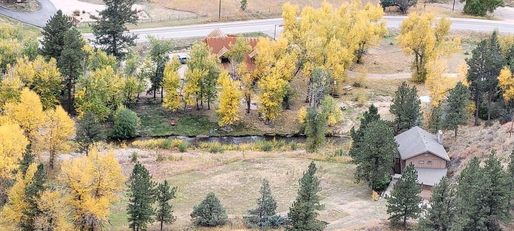
Just a few more days of color to go up here, but I did capture this yesterday looking down from my deck to the North Fork of the Big Thompson.
-
On 10/3/2021 at 7:01 PM, Chinook said:
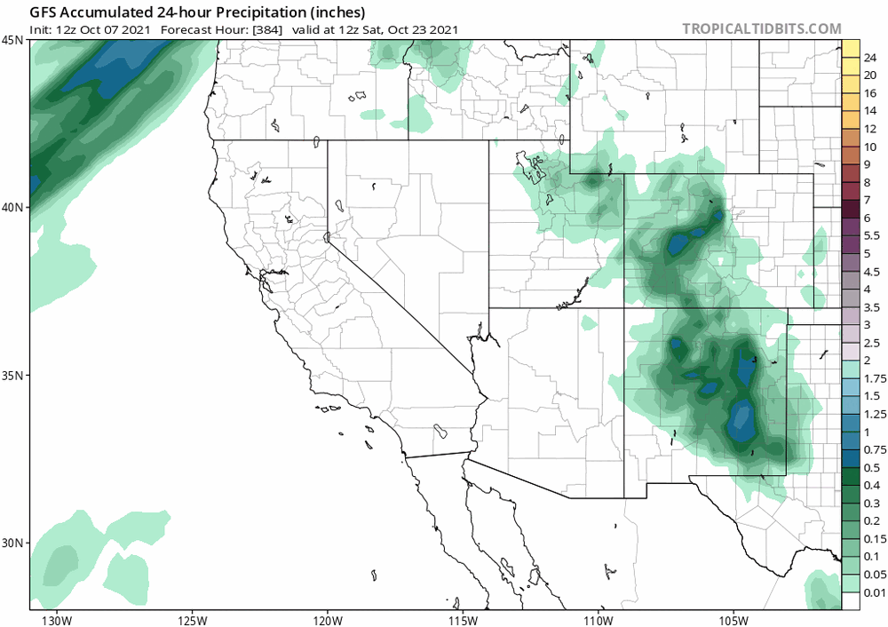
This seems intriguing. Perhaps 10/9 might be an interesting day to see what the ensemble averages have for 10/19
GFS is starting to show something way out at +384, which is a few days later...around the 22nd, with highest impact for NM. It will be interesting to watch this one as we move out of fantasy land.
-
1 hour ago, raindancewx said:
Still there. Time-frame on this is 6 pm Saturday. So 10/2 evening +17-21 days. Roughly 10/19-10/23 or 10/20-10/24 for a storm for NM & CO. Roughly speaking, Kamchatka functions as the Rockies in the Bering Sea Rule. So the storms south/east of Kamchatka can pull in Gulf of California and/or Gulf of Mexico moisture depending on the path they take.
I sure do enjoy reading your posts in the fall/winter/spring. You know it's definitely time to start that winter thread when Raindance is talking about Kamchatka.
-
Yeah, get that winter thread going. I actually had to fire up the heater this afternoon. Up here, sitting at a balmy 42 degrees and socked into the cloud deck with very limited visibility. It feels November'ish...
-
1 hour ago, cptcatz said:
Looks like the only land at risk is Bermuda. I'd watch that next wave to see if it can sneak into the Caribbean.
Not sure that one has much chance. Sam will leave a pretty good cold pool in it's wake, and even so it's recurve will allow anything that forms from that wave to rotate up and around the ridge. I think Sam is it for CV threats this year, imho.
-
6 hours ago, AppsRunner said:
Outside of Tuesday the long range pattern looks hot through the majority of September. How far will we go into October before we see snow?
The mountains have already had snow this year (a couple of weeks ago). For my area, ~Estes Park and Larimer county above 7k', I will predict Oct 7th. This is a very average date for us over the past few years. Last year was a very notable exception on Labor Day.
-
It looks like yesterday was good for a lot of areas. The hail scenes on the news were a bit interesting...fortunately it appeared to be mostly small hail but it did accumulate nicely.
-
13 hours ago, mayjawintastawm said:
yeah- soil type (less permeable here, very drainable there), prevalence of streams to drain water away (few here, more there), and terrain (steeps and plains here, rolling hills there) are all different. I don't know much about flash flood modeling, but I imagine there is an algorithm that takes those into account.
Well, quite ironically....Phillips County in the far NE plains received up to 9" of rain last night.
-
I was just thinking last weekend that we have largely escaped large hail events this season. Sounds like that was a bit premature.
-
That sort of rainfall can indeed happen in Colorado, but with devastating effects. The 1976 Big Thompson flood is quite the example. From Wiki:
On July 31, 1976, during the celebration of Colorado's centennial, the Big Thompson Canyon was the site of a devastating flash flood that swept down the steep and narrow canyon, claiming the lives of 143 people, 5 of whom were never found. This flood was triggered by a nearly stationary thunderstorm near the upper section of the canyon that dumped 300 millimeters (12 inches) of rain in less than 4 hours (more than 3/4 of the average annual rainfall for the area). Little rain fell over the lower section of the canyon, where many of the victims were.
Around 9 p.m., a wall of water more than 6 meters (20 ft) high raced down the canyon at about 6 m/s (14 mph), destroying 400 cars, 418 houses and 52 businesses and washing out most of U.S. Route 34.[6] This flood was more than 4 times as strong as any in the 112-year record available in 1976, with a discharge of 1,000 cubic meters per second (35,000 ft³/s).
-
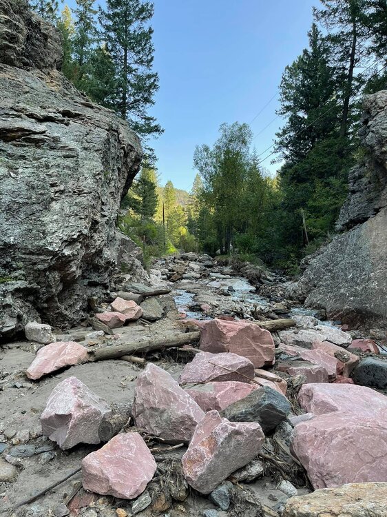
We got more this evening, about .3". It's crazy to see the feast or famine over the past 6 weeks. Regarding the boulders, this road is directly below a ridge that was burned in Cameron Peak fire last summer...hence the unobstructed flows coming down the mountain in the drainages. Burn Scar flooding is no joke we are learning, and it doesn't require a huge rain dump.
-
 1
1
-
-
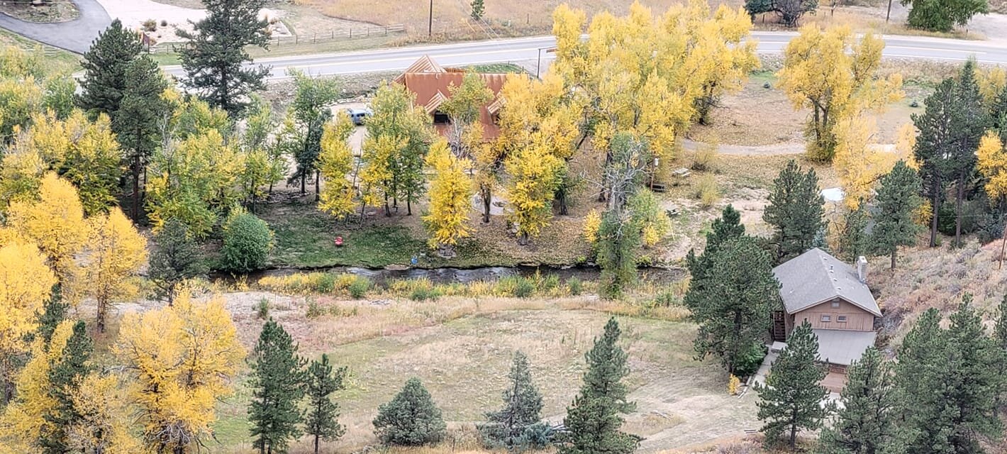
It's hard to be ungrateful for additional monsoonal moisture, but we've had enough up here. This photo is of Black Creek Road in our neighborhood. It is one of two county owned roads in the neighborhood, and Larimer has rebuilt it twice since July 4th. This is it's current state which is amazing and frankly hard to believe considering that most of the series of floods have been caused by events of an inch or less of rain. There are homes on this road, so not just a minor nuisance.
-
1 hour ago, BuffaloWeather said:
Heading out west to Wyoming, Idaho, and Montana Aug 18-28. Anyone know what the smoke will look like when I am there or too early?
It's way too early to tell based on smoke forecasts, but given that Idaho and Montana have a lot of wildfires currently ongoing....I would expect those areas to be inundated. Wyoming would likely have more dependency on the smoke impacts from wildfires in neighboring states.
-
 1
1
-
-
This morning the divide looks remarkably clear to my west. Fingers crossed that we get one day of semi-clear air. Between the days and days of rain up here and the days and days of smoke, we haven't seen any bluebird days in quite some time.
-
2 hours ago, mayjawintastawm said:
Flash flood emergency for the Miller Fork and North Fork of the Big Thompson, due to heavy rain on burn scars. Glen Haven and Drake are in some trouble. These are some of the areas hit hardest in 2013.
Yup and that is my neighborhood (The Retreat). We have been having burn scar flooding periodically since July 4th. We have already lost two roads in the neighborhood from crazy washout. Today was the roughest though. Several hours of rain today but it has stopped for now. The North Fork is fine but pretty full. It gets dicey where the Miller Fork meets it. Coal black water...


Mountain West Discussion
in Central/Western States
Posted
I recorded a 68MPH gust up here at 11:08am. So far (and thankfully) a rather run of the mill winter wind event up in this part of the foothills. I think it is perhaps a bit different story from Boulder and points south, like Bailey and Evergreen areas. It would be interesting to see more reports from down in that area.