

ValpoVike
-
Posts
563 -
Joined
-
Last visited
Content Type
Profiles
Blogs
Forums
American Weather
Media Demo
Store
Gallery
Posts posted by ValpoVike
-
-
16 hours ago, Chinook said:
At my current location in Ohio at 41.5 degrees north, sunrise is 6:03AM and sunset is 9:01PM. At Fort Collins it is 5:32AM and 8:24PM. The sunset time is a difference of 37 minutes, plus extras due to the mountains. For an equivalent location with latitude of 41.5 in Wyoming, directly north of Fort Collins, it would be 5:29 and 8:27.
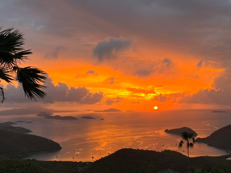
So 6 minutes delta due to latitude. The shift due to longitude within the respective time zone is big though especially if you like a late sunset. Coincidentally I was thinking quite a bit about that over the past week while on vacation in the USVI where sunrise was about 5:45am and sunset was about 6:48pm earlier this week…with total daylight of 13 hours, 3 minutes versus Fort Collins at 14 hours, 52 minutes. My mind often fixates a bit on such matters to the great annoyance of my wife.
Here is a photo I took of one of the 6:48 sunsets
-
 1
1
-
-
It was crazy smoky and on Friday. Visibility was down to about a mile up here, very similar to bad days during the CP fire but without the smell. That is remarkable given the distance to the fires in Canada.
-
54 minutes ago, Newman said:
Just finished up my undergrad meteorology degree at Millersville in PA. Will be moving to Laramie, WY come late July to settle in for grad school at UWYO. Excited to be apart of the Mountain West and to join y'all
Welcome!
-
Just light rain up here, and only .13" today so far. I wouldn't mind getting to 1", but we don't want it all at once due to burn scars in the neighborhood.
-
We had quite the lightning show to kickoff the spring/summer thread up here around 10pm last night, but it moved thru pretty quickly. Today is rather socked in with low ceilings and current temps in the 40's. BTW, did NWS Boulder get a new forecaster? The AFD this morning was rather colorful.
-
3 hours ago, mayjawintastawm said:
Two things really surprised me about that storm: 1) the snow level for real accumulation was much higher than forecast- looks like about 7500 feet; and 2) the total precip was much, much less than forecast south and east of the Metro area. Heavy precip over 2 inches was confined to the Pueblo area. Even SE Colorado got shafted. If it hadn't been for the convection earlier in the day, it would have been bust-o-rama for everyone.
That’s about right. I am at 7310 and about 100’ above me got light accumulation. Around 8500 it looks like considerably more from what I can see today. Does anyone know how much rain fell north of DIA? It looked like some very slow movers in that area.
-
A big bust up here. My neighbor 100’ above me has about an inch on the ground. I have nothing but a wet deck. I have casually noticed that the Pinpoint Weather app from Fox31 has outperformed the WPC guidance all winter for my backyard. Strange and sad.
-
 1
1
-
-
06z GFS actually puts the heaviest north and west of Denver bullseye on Larimer and Boulder. Euro likes Denver and loves the Palmer divide. Clearly someone is gonna get pasted

edit: holy smokes look at the 06z GFS QPF, broad 3” with some crazy 4”+ amounts. NAM is trending similarly thru the end of its run.
-
2 hours ago, mayjawintastawm said:
Nice 2.5" of snow last night, the most moisture at one time in a couple months. Pretty.
Cool and happy you finally got some snow. Next week looks interesting, especially for the foothills. Both GFS and Euro show a dumping across the Boulder and Larimer foothills. The lower elevations may get a nice soaking. But we’ll see if it survives the next day or two…
-
1
-
-
23 hours ago, ValpoVike said:
Even more from the euro.
Poof, gone.
-
Even more from the euro.
-
1 hour ago, smokeybandit said:
Final tally about 6" after the overnight bands
Awesome. I have no idea how much we got here as it would pour snow, stop for a bit, pour snow again…and with the temps fluctuating between 31 and 35 coupled with warm ground temps, I had fast melting.
-
I woke up to 40 degrees and it has since dropped to 32 with a nice moderate snowfall kicking in over the past half hour. The air feels juicy in that spring snowstorm way and winds have come around from the east. I have cautious optimism for the storm to produce decent amounts up here in the Larimer foothills. We’ll see…
-
3 hours ago, mayjawintastawm said:
Looks like tomorrow might be the first rainy day in >6 months for the Front Range. Bring it on! Now of course that means it will go "poof".
WWA issued up here along with thunder. As is typical for April and May it looks like a fairly sharp gradient on accumulations.
-
On 4/8/2023 at 3:18 PM, smokeybandit said:
Then possibly snow next weekend.
Ah, Colorado spring.
The Euro is starting to give ground and given that the GFS was never really onboard, it is looking like this storm will be a non-event unfortunately.
-
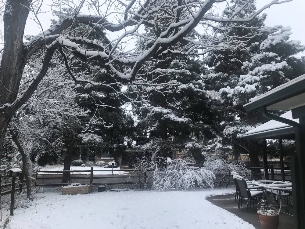
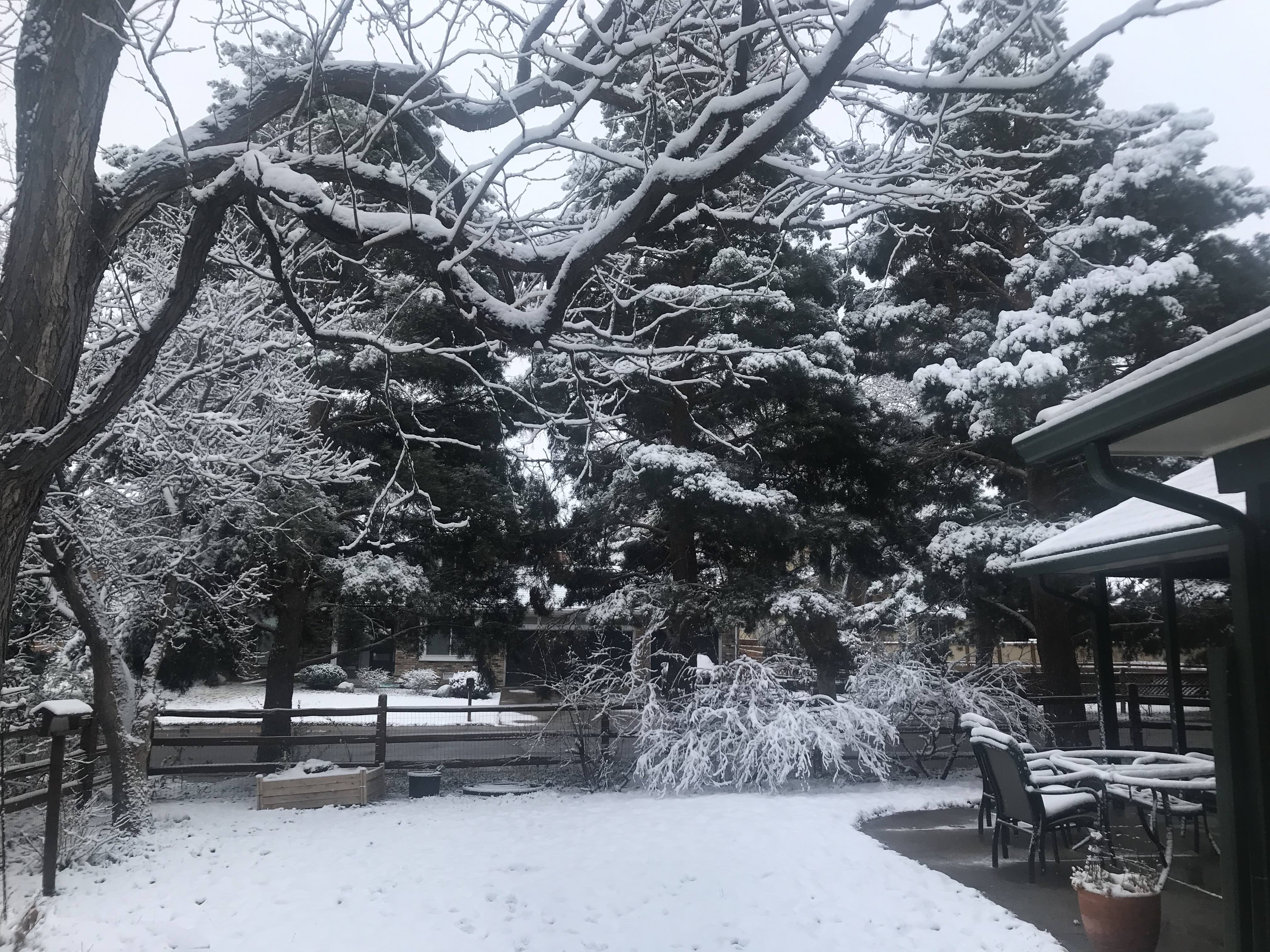
Spring has finally arrived in the front range. I do love the winter, but I also really appreciate spring when it comes. We ended up with a couple of rounds in one day that added up to probably 8”, but the roads never became treacherous. Another great thing about spring…
-
I wasn’t expecting much but picked up 4.8” overnight.
-
10 hours ago, Chinook said:
A large storm system on Monday night will most likely be a close call for heavy snow at Fort Collins and Estes Park.
.thumb.png.a3e0df1dc4d2fc991cfd8088bead4157.png)
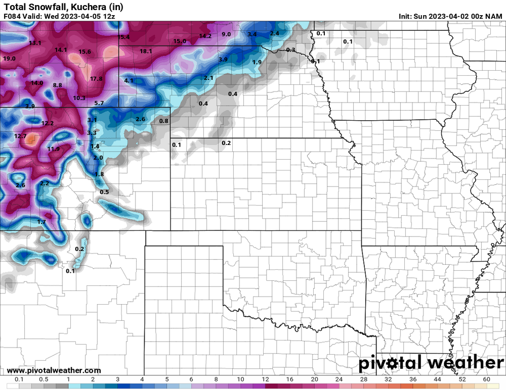
Only 1-3 forecasted here, however thunder is mentioned.
-
A nice upside snow overnight and this morning up here. Currently standing right around 5", but a bit hard to get an exact amount due to some periodic gusts. Regardless, we have outperformed the forecast "of less than 1 inch". So far this season has had a bounty of 3" snows, but a lot of busts on calls of higher amounts. Good to finally see an outperformer. Still waiting for the big one or two for spring...
-
30 minutes ago, mayjawintastawm said:
So, the "low end forecast" for snow from this "storm" was 2.2 inches. We got 0.8", if I lean the ruler over just right. And there were supposed to be some wind gusts. Max wind at our house was maybe 12 MPH. Well. It is cold like was forecast.
Yeah pretty meh. I did get about 5” but that is far short of the 7-12 forecasted. This has been typical all season in my neck of the woods. Fortunately we have nickled our way to a not too bad winter though. I do hope we get the March dumps this year.
-
2 hours ago, jacindc said:
@Chinook What ratios would you generally use for snowfall out in these parts? (Wyoming, Colorado, etc) Looked like your post earlier this week was using a range of about 10:1-15:1?
I know Kuchera maps are called clown maps for a reason
") , but I was wondering if they handle things better where precip type is not much of an issue.
, but I was wondering if they handle things better where precip type is not much of an issue.
Thanks for helping me get up to speed on an entirely new climate!
Ratios can be frustrating here. Personally I use 10:1 as I have seen too many storms with much higher predictions miss terribly.
-
1
-
-
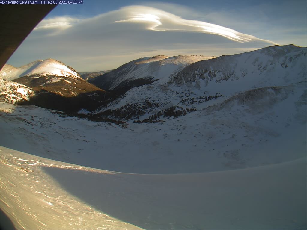
1 hour ago, Chinook said:
finally caught a good cloud

Great grab. I have been admiring that cloud all evening. It is spectacular.
-
15 minutes ago, Chinook said:
This was a snow storm for Colorado, just not where any of us live (or lived, in my case.)
.thumb.png.9766463f32e3f8440bcad7ed0eb7fc57.png)
It is good to see snow in the SE corner though. They are in D2-D3 still.
-
Yeah a snoozer but seems to happen more often than not in early January. I did spend the week in Santa Clara on business and got the full rain experience. It was crazy.
.png.c83bc42ccd16ffc9c65c1cce33c417ef.png)

.png.e8ae3c787328798fa788dab3c1634a02.png)
Mountain West Discussion
in Central/Western States
Posted
Dang, summer made it finally!