

ValpoVike
-
Posts
563 -
Joined
-
Last visited
Content Type
Profiles
Blogs
Forums
American Weather
Media Demo
Store
Gallery
Posts posted by ValpoVike
-
-
16 hours ago, mayjawintastawm said:
Crazy, and Leadville is 5000 feet higher too.
Yeah it has been upside down over the past 24 hours. My low was 45 up here this morning while Ft Collins is currently sitting at 22.
-
My low was -10 this morning as well.
-
Useless but interesting fact - My wife is visiting family in Wasilla, Alaska this weekend, and currently it is 30 degrees warmer than my current temp of 7.
-
It's going to get cold for sure. Interestingly, I have noted over the past several years that January 10th-17th almost always features extreme cold for the front range. Last year it was on January 13th, with -19 recorded here. I don't have specifics for other years logged for my location, but I did start a log last year. It will be interesting to see in a few years how it holds up.
-
 1
1
-
-
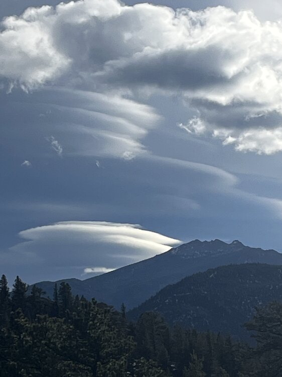
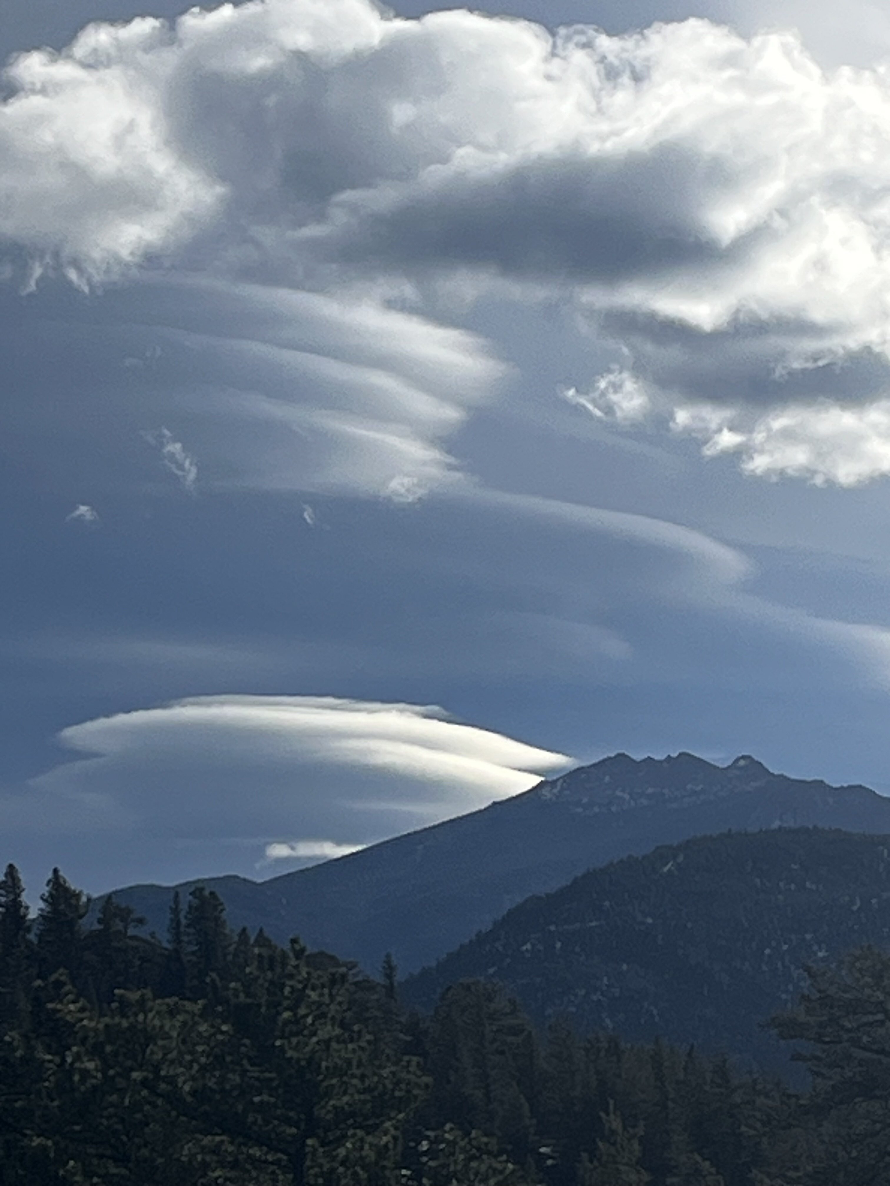
I took this while hiking the Twin Owls trail in RMNP today. One of the best days for lenticulars in quite some time.
-
2
-
-
Several days ago I just couldn’t believe the QPF that the euro was showing. It looks like it largely nailed it…but having only scored about 3” up here, I am indeed rather jealous.
-
2 hours ago, smokeybandit said:
Euro joining the FantasyLand (though, not too far into FantasyLand) fun.
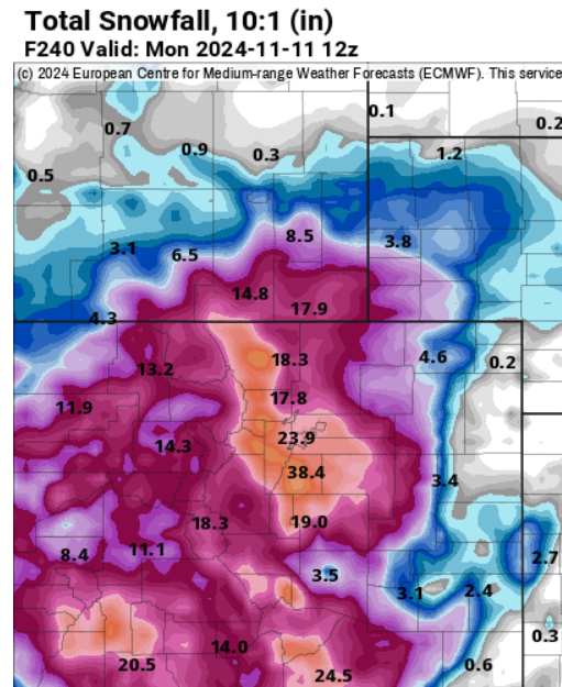
Crazy amounts for sure, but the trend does seem to be pretty strong directionally for good moisture over the next 10-14 days.
-
1
-
-
I picked up about 1.5" yesterday, with most coming in the evening. Not much, but I'll take it...with an eye on early next week to add.
-
I think we may need a cold season thread starting on Tuesday.
-
2 hours ago, mayjawintastawm said:
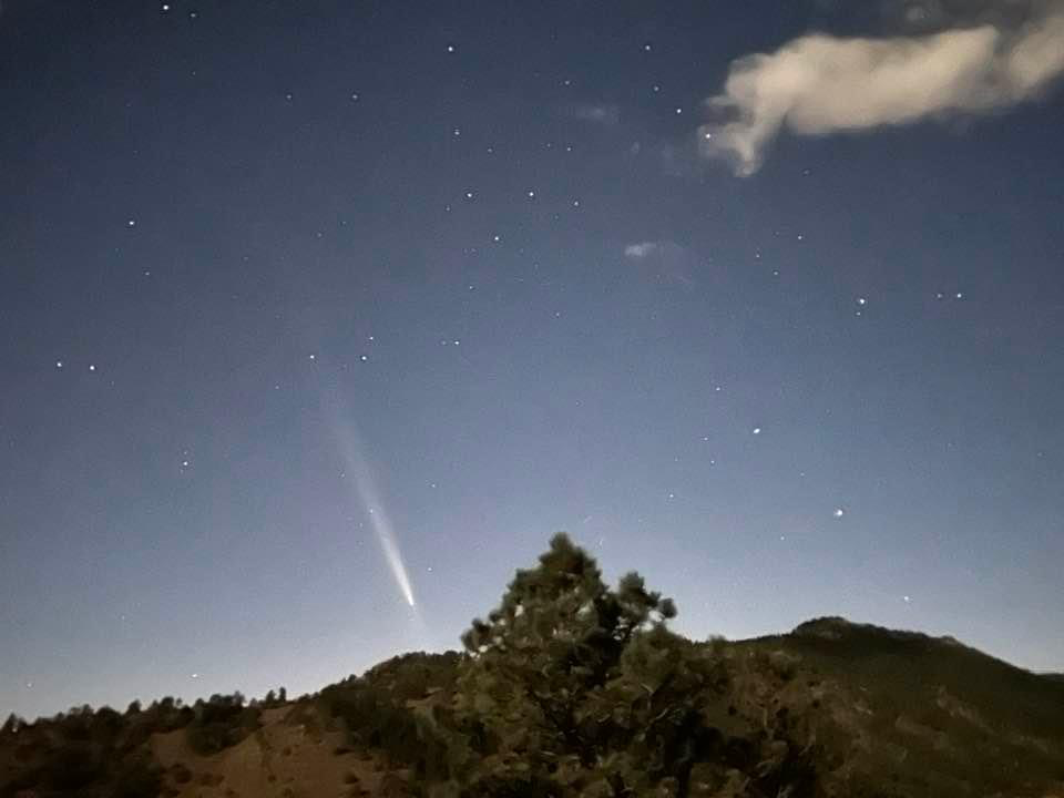
Fantastic! Could you see it with the naked eye or did you need binoculars to spot it?
We've had clouds to the west and southwest at sunset persistently over the last 3 days, not to mention smoke up against the foothills from the WY fires (I'm assuming).
It was very visible to the naked eye. Yesterday it was at mag 1.5, and I believe this evening it will be 2.5. For sure a bit dimmer this evening and there is a lot of smoke up here, so I don’t have my hopes up too much for a spectacular encore.
-
1
-
-
Another crisp evening, with a celestial bonus.
-
2
-
-
It appears that I will land at 2.97" for August. For my location, it was a productive and nearly perfect monsoon with almost daily rains coming in roughly .1" increments with a couple of of .5" days. More broadly, it did seem to be a mixed bag for August with KDEN logging just under an inch for the month.
-
18 minutes ago, smokeybandit said:
1.4" of rain this afternoon. I'll take it!
Sweet!!!
-
Yeah, and all of this monsoonal moisture is coming just in time:
-
 1
1
-
-
1 hour ago, Chinook said:
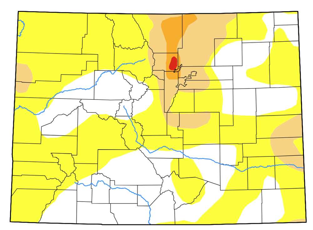
This is pretty cool. By the way, 5-day forecasts have a fairly good amount of precipitation for Colorado
Yeah, totally socked in up here all day long in the fog. A very fall-like 55 currently.
-
We picked up .6” of rain today here on the western edge of the Alexander fire. It was a steady and gentle soaking too.
-
I am currently in evacuation on the Alexander fire, marking the second time in four years. Come on Monsoon…
-
Icky and smoky up here. The consolation is that it is not local smoke…yet.
-
19 hours ago, smokeybandit said:
Finally some rain. Only 0.4" but I'll take it and I won't admit being bitter that literally a mile away they're pushing a full inch.
Same here, where it is a bit frustrating to see decent QPF all around me. Meanwhile I have been clocking a steady .05"/day for quite some time. But even that I will take.
-
We have done a little better up here. It was dry until a week ago, and over the past week we have had daily .05” rains or so. The past two days have logged a quarter inch each. Not a ton, but better than it could have been. Temps have been quite seasonally average up here, likely tempered by 2pm’ish daily rains and cloud cover.
-
1 hour ago, mayjawintastawm said:
truck OK?
Yeah, no pings!
-
1
-
-
5 hours ago, mayjawintastawm said:
No LSRs and no news reports mentioned DIA, although the climate report for 5/30 said hail was observed during that storm. If they didn't receive damaging hail, it was mighty close. If the storm had been 8 miles further northeast, we'd have many many millions in damage to cars and airplanes. I would kind of like to see how sizable hailstones bounce off that big tent over the terminal...
My new truck is at Wally Park, so was extremely curious. Guess I will know for sure on Tuesday!
-
Does anyone know if DIA received damaging hail?
-
3 hours ago, smokeybandit said:
I saw pictures from all over the area of the aurora. yet I drove 10 minutes down the road to get away from as much light pollution as possible, and saw absolutely nothing.
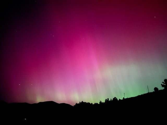
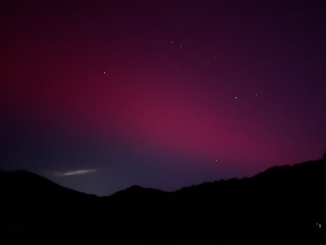
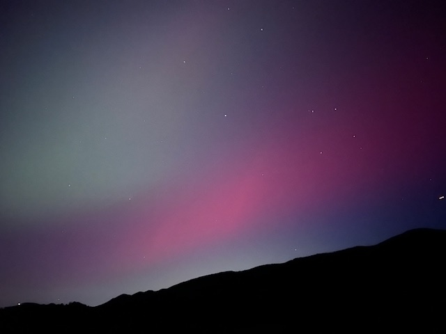
Up here and with good dark skies, starting around 9:15pm I could just make out the aurora but when I pointed my iPhone, and wow. I got some excellent photos and the aurora filled the sky in all directions. Around midnight the aurora brightened very considerably and was easily visible with the naked eye, but only to the northwest.
I hadn’t see and aurora since the Halloween storm in 2003. The first image is at midnight and the others from earlier in the night all taken in Glen Haven
-
4
-

Mountain West Discussion
in Central/Western States
Posted
Yep it’s March, thundersnow for the past 10 minutes.