

ValpoVike
-
Posts
514 -
Joined
-
Last visited
Content Type
Profiles
Blogs
Forums
American Weather
Media Demo
Store
Gallery
Posts posted by ValpoVike
-
-
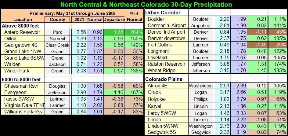
2021 Monsoon part 2 on it's way today and thru the week. I am cautiously optimistic that we won't have the insane repeat of last years conditions. The two "long duration" fires, Muddy Creek and Morgan Creek, are not rapidly growing. Still a lot of fire season to go, but at least we are getting decent monsoons this year.
-
We got hit today by 3 strong cells. And we also got hit by the most specific flash flood warning I have seen, for only our neighborhood. The burn scars sent a nice wall of water down two streams and took out a couple of roads. It has rained for 9 out of the last 10 days now.
This is the Larimer County Sheriff's Office with an emergency message. Dangerous flooding is occurring in The Retreat Area of Glen Haven. Streamside Dr and Fishermans Ln are the most impacted areas at this time. Immediately reach higher ground by any means necessary. Avoid area subject to flooding including dips, low spots, ditches, etc. and do not attempt to cross flowing streams or creeks. If driving, be aware that the road may not be intact under flood waters. Never drive through flooded roadways - turn around and go another way. If your vehicle stalls, leave it immediately and seek higher ground.
-
FoCo kinda stands out here:
-
Some Lenticular clouds starting to form. It is hard to tell from my vantage, but looks like it may be over Long's.
-
This moisture has been great to see. Rain every day since Thursday. Perhaps a bit too much on Saturday night when we had a rather long duration of several hours of moderate rain and we had some burn scar issues up here. We lost a portion of a road in our neighborhood due to a blowout upstream with debris flowing down. But I'll take that over last summer's relentless drought.
-
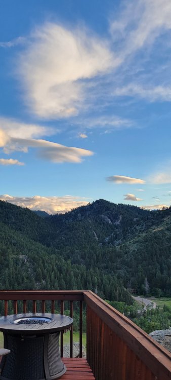
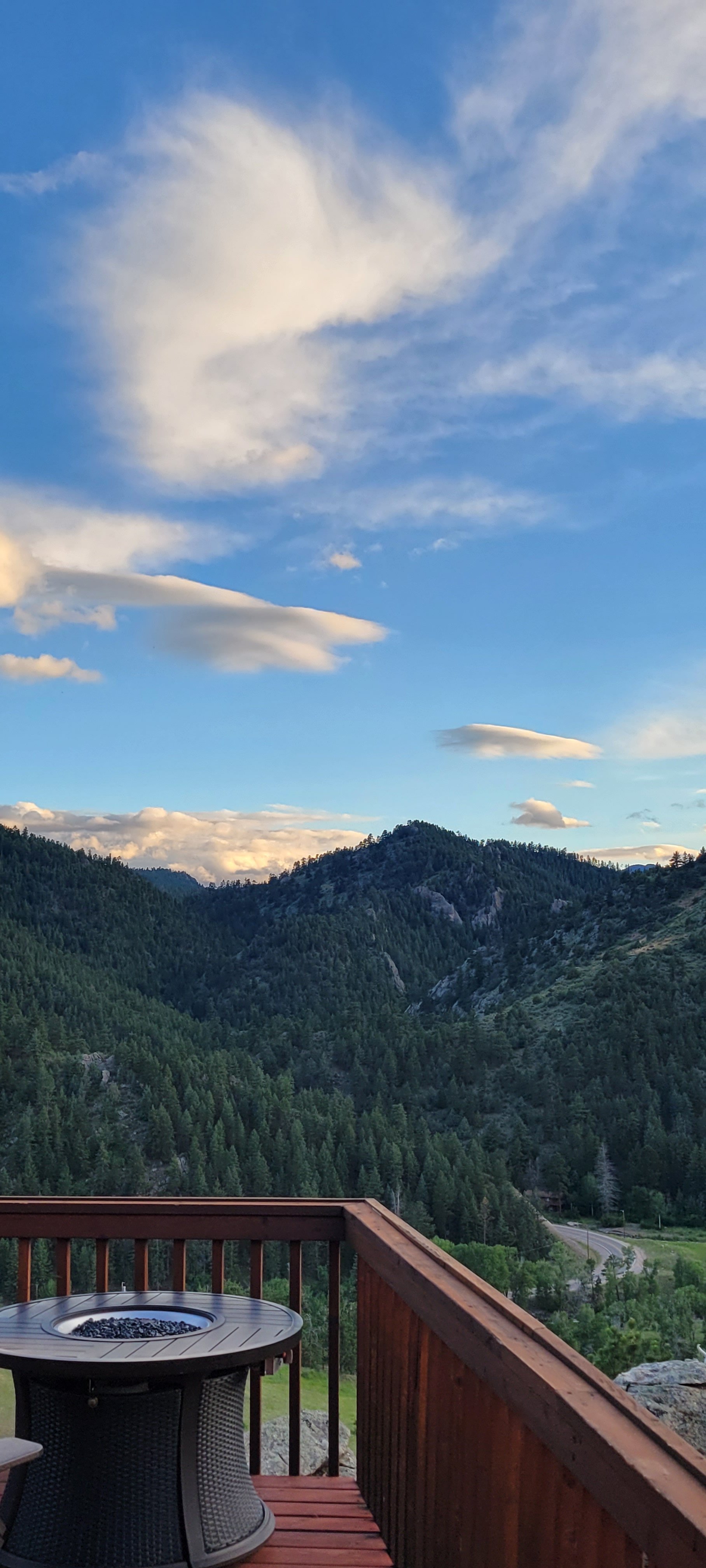
I shot this off my deck this evening. This is looking east towards Loveland.

-
On 6/13/2021 at 9:36 PM, Chinook said:
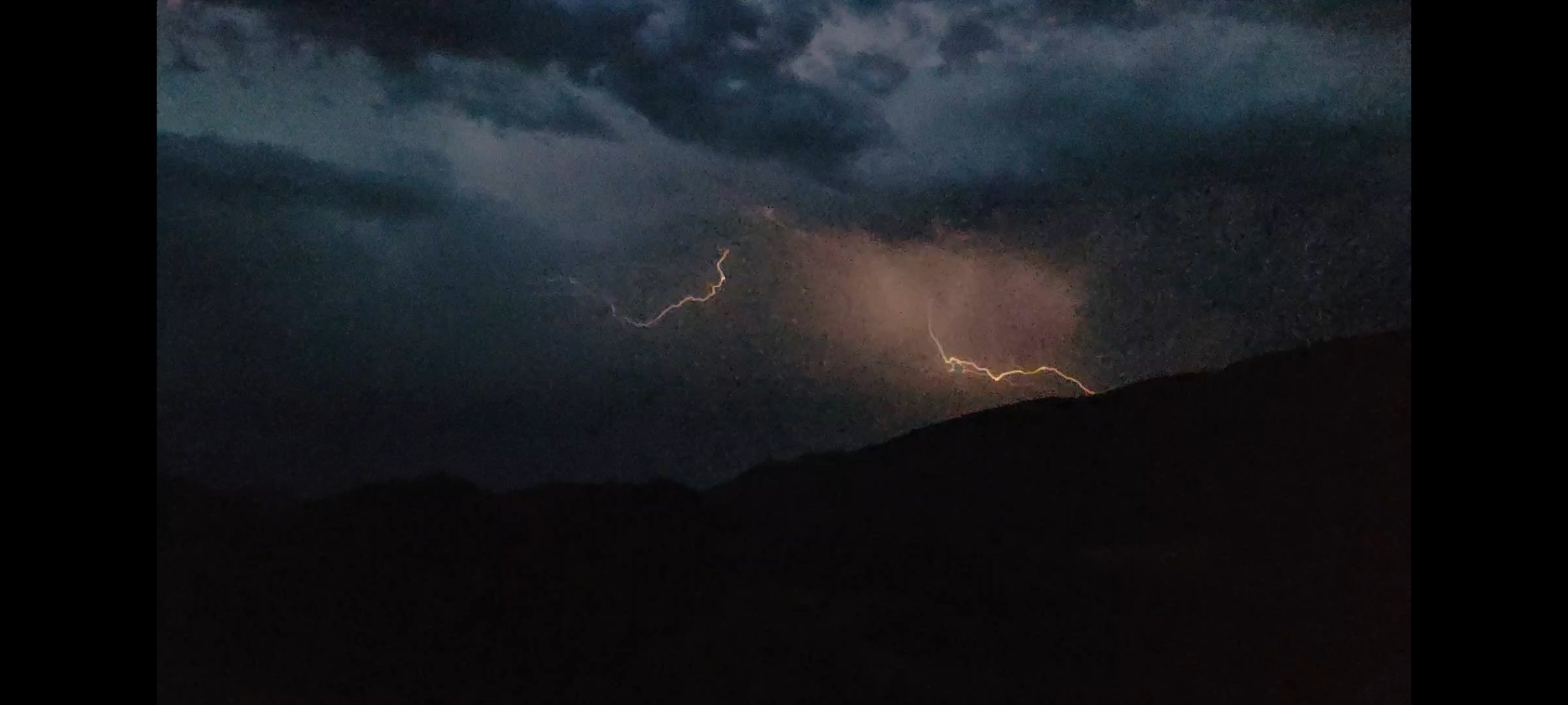
Some storms built over my area, going slightly westward at sunset. Despite the rainy month of May, this is only the 2nd day when I have seen lightning this year.
I watched the radar loop on this on Sunday, and it was the oddest storm motion that I can recall. It stumbled like a drunken pirate...moving northeast, then west, then a very sudden about-face to move east before dissipating. The anvil was a beautiful site from up here though.
-
42 minutes ago, finnster said:
The abundant spring moisture and cooler temps on the northern front range have sure been a blessing. As we passed into June it seems a switch just got flipped, and now I'm starting to feel uneasy (again)
 . Now we're in to a pattern of hot and dry weather - if that is the case until October (like most of recent summers) I'm going to be seriously bummed. Someone please tell me we're going to have some semblance of a monsoon pattern this summer at some point!
A typical summer pattern so far the past week. Up here in Glen Haven we thankfully have had good short lived heavy rain the past couple of days, but that is just by luck as most of the front range has not seen these. You're spot on that it comes down to the monsoon.
Western Colorado is still in a rather dire scenario that the monsoon won't fix.
-
13 hours ago, Chinook said:
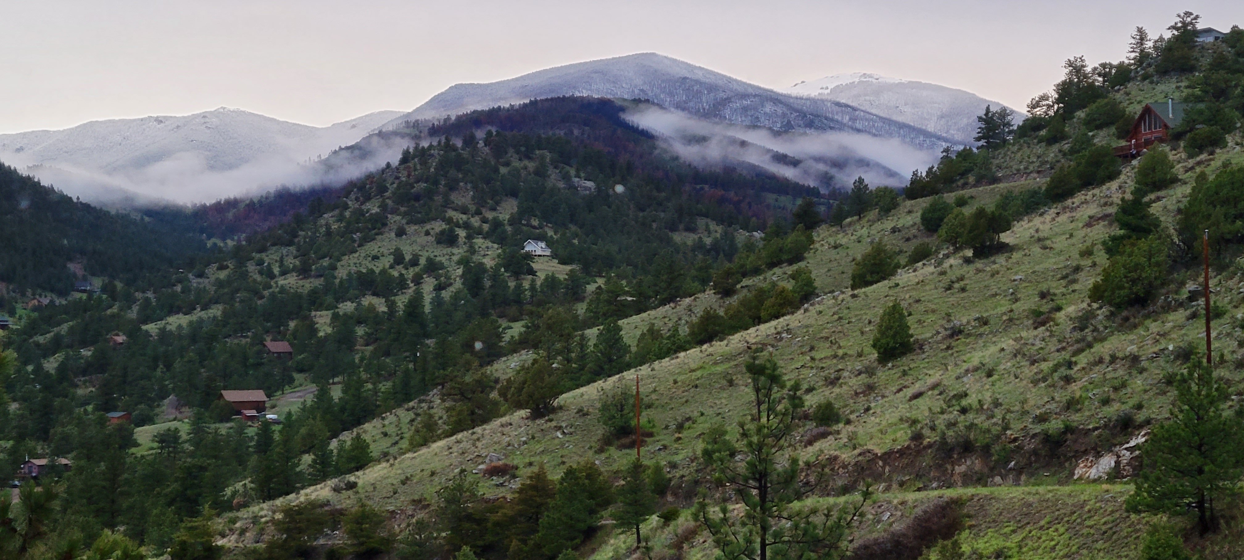
Many times recently I have looked over toward the Mummy Range and Long's Peak, and the snow looks pretty thick for this time of year. Here's a neat pic, reposted by Jim Cantore
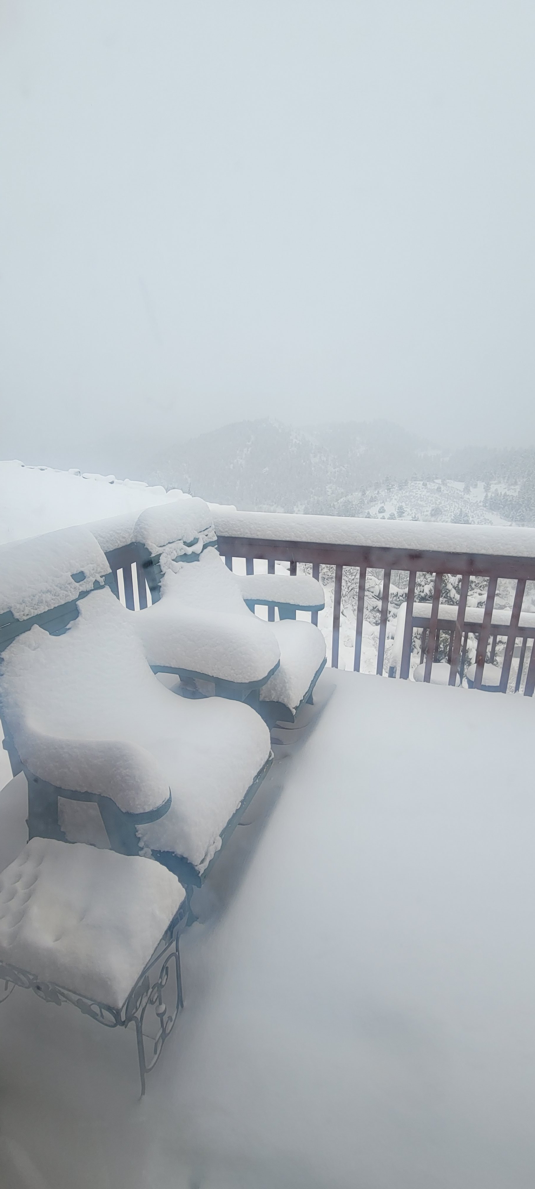
That is a cool photo. Below is a photo of fresh snowfall that I shot yesterday/Sunday evening from my deck looking west up the North Fork of the Big Thompson. Signal Mtn is on the right and Mt Dickinson to the left, with Mummy Mtn off camera a bit further left. Right of center are some burn scars from the Cameron Peak fire which have been quite useful in revealing snow coverage from a couple of miles away. Anyways, it is stunning out with all of the green popping out everywhere with the backdrop of fresh snowfall.

-
2 hours ago, smokeybandit said:
Quite a bust of a storm from the GFS/NAM.
Euro had it right, very little moisture outside of the foothills.
This year GFS = Generously Forecasting Snow
-
Not too bad up here. Woke up to about 2" this morning, that melted by noon despite steady snow. It started accumulating again in the early afternoon and we are probably back up to 3" of new accumulation. It's not really accumulating on road surfaces, just on decks and grass. All in all a very typical May snow.
-
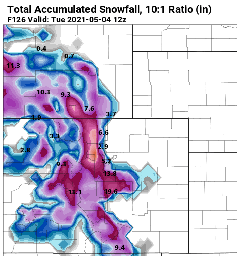
Yet another juicy storm on tap for early this week. I think this makes the 3rd "early in the week" storm in a row with generous QPF. This one feels a bit more interesting with respect to snow accumulation. It looks like 6500 feet and higher may do pretty well this time around, versus the 8000 foot consistency in the prior two weeks. Not that I am pulling for 10-12" up here, I'm kind of done, but I think it is possible.
-
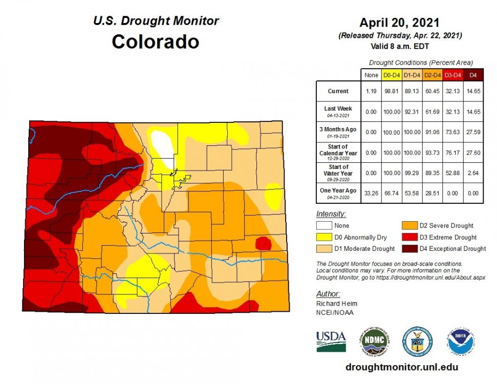
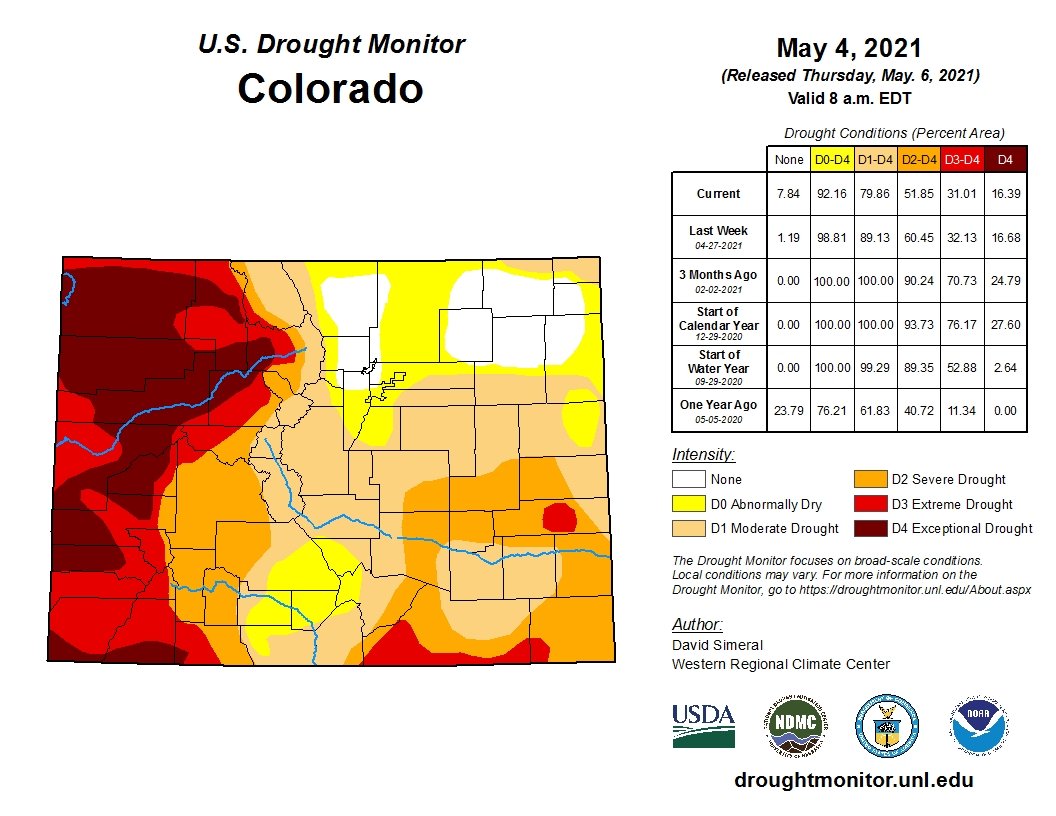
On 5/5/2021 at 3:25 PM, n1vek said:
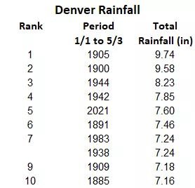
I am very interested to see the Colorado drought map when it is released tomorrow. Last week's iteration didn't catch the Tuesday/Wednesday storm. Add that to the rain we received Monday and we could see additional drought improvement vs the map shown above.
Here ya go. Very good improvement over the northeast.

-
 1
1
-
-
I came across this from NWS Boulder's Facebook.
-
2 hours ago, smokeybandit said:
GFS not ready to post in that thread
I'm not sold on this. I think it will end up a lot like this week's storm....good for the mountains but a melty mix for lower elevations. Perhaps I am wishcasting a bit as I am really ready for winter weather to end
") . I am at ~7300' and my home is surrounded by 9k'+ mountains....this week was interesting as I could see a clear snowline just over my head, probably around 8k'
. I am at ~7300' and my home is surrounded by 9k'+ mountains....this week was interesting as I could see a clear snowline just over my head, probably around 8k'
-
Feels to me like timing for a spring summer thread is just about right.
-
It really comes down to the Monsoon. We were in great shape exiting snow season last year, but no monsoon. Raindance, do you happen to track analogs for the regional monsoon season?
-
Well, at least some good news for portions of Larimer and Boulder counties.
-
1 hour ago, mayjawintastawm said:
3.7" last night, 4" last week, season total now up to 83.7". Pretty sure this is a top 2 season for me since 2010. I think we can about stick a fork in this one, having begun 7 1/2 months ago. I kind of hope. Bring on hail season
Maybe after tomorrow a fork can be put in with models pointing to a few inches on Wednesday. But the NWS says - Meh. Up here we have had a pretty good season, though I honestly have no idea how much total snowfall has occurred. We even picked up some surprisingly good snows on Labor Day and again in late October. March and April have been good to us as well. In between was underwhelming.
I'm ready for snow season to end too, and also hoping that the Monsoon actually shows up this year. The lack of a real monsoon last year seems to me to be what drove the massive fires last year.
-
We have done pretty well this week.

-
1
-
-
It's been a steady nickel/dime event up here in Glen Haven. About 3" on Tuesday, and about the same amount again yesterday evening and night. The road surface melting in-between has been welcome...so bring on the moisture! I did have a hairy experience on the switchbacks north of Estes on CR43 where a layer of ice had formed under a layer of snow Tuesday evening, that was not fun at all as my Jeep nearly hit a guardrail despite crawling down at 5mph.
-
The precip is going to be spread out over most of the week, and temps will be quite marginal. I think snow that does accumulate will melt fairly quickly, and especially down in the lower elevations there will be more mix and periods of straight rain.
-
24 minutes ago, smokeybandit said:
GFS starting to spit out numbers like its now-retired cousin was prior to the blizzard
Yeah, Larimer and Boulder counties get hammered by the "new" GFS.
-
Both the GFS and Euro are showing some impressive QPF and snow early next week for the front range,. Temps really look suspect though, and it will be interesting to see how this plays out.

Mountain West Discussion
in Central/Western States
Posted
A tragic day of flooding yesterday on Hwy 14 along the Poudre River, in the Cameron Peak burn scar. This from the Larimer County Sherriff's Facebook page:
I just returned from the Poudre Canyon flood incident that originated around Black Hollow Road, just west of Rustic earlier tonight.