

ValpoVike
-
Posts
514 -
Joined
-
Last visited
Content Type
Profiles
Blogs
Forums
American Weather
Media Demo
Store
Gallery
Posts posted by ValpoVike
-
-
5 hours ago, mayjawintastawm said:
No posts in a week so I thought I'd bump this up.
Drought monitor for CO is only slightly better despite the snow/rain early last week. Lots of D3 happening.
Denver has a couple more chances to break the all-time record for most 90 degree days in a year, currently tied with 2012.
Anybody have anything else to report? Still quite warm and dry and smoky here, though the (irrigated) tomato harvest is better than it's been in quite a while. (were able to protect them last week)
We have been in the voluntary evac zone along CR43 from the Cameron Peak fire since Labor Day. Thankfully the snow really put the hurt on it, but it got pretty close that Monday and we got out. It was hairy for a while and we wondered which would get here first, snow or the fire. We came back in the snow the following day. I spent all of that day closing the pool so that pipes and pumps wouldn't freeze...what a bizarre two days that was. It has been tranquil up here ever since, gentle winds with temps in the 70s and nice cool nights.
-
5 hours ago, Chinook said:
The surface smoke has come back - it smells more like campfire smoke than any day since the worst days of the High Park Fire.
It was choking smoke all day here, with an eerie reddish twilight look...or one of the levels of the underworld. A lot of people are waiting for snow and cold up here.
-
13 hours ago, Chinook said:
Ash is falling from the sky.
Unfortunately, the fire made a very impressive run yesterday and overnight. An inversion set up overnight and kept temps in the 70's at higher elevations, so while the fire laid down somewhat apparently it was still fairly active overnight. The end result was an ~8 mile run to the east near Crown Point pushing into Pingree Park, and today will be very similar. They had set up containment lines along Crown Point road, but the fire apparently jumped them with impunity. On the south side, the fire pushed into RMNP and Comanche Peak Wilderness towards Comanche Peak and Mummy Mountain. Expect a lot more ash today, and the snow cannot come quickly enough. Here is a photo taken from my deck around 4:30pm yesterday/Saturday when the skies turned black.

-
 3
3
-
-
4 minutes ago, AppsRunner said:
No headlines for the mountains today, but probably coming soon. Metro still a question mark but at least some snow accumulation looking like a safe bet. Meanwhile 101F today is the all time September record
What are your thoughts for western Larimer, over the Cameron Peak fire? The models are crazy and not sure what to think.
-
12 minutes ago, mayjawintastawm said:
New PWS installed last night! It's a bit close to the roof so monitoring for too-high temps in the sun, but today it seems in line with other readings nearby. Wind, of course, has accurate direction but not speed. Trees in the neighborhood prohibited any accurate siting for wind. 98 for a high so far, that might be it. Temp rose 39 degrees in 4 hours this AM. We shall see what the drop looks like Mon/tues. Hope the rain sensor gets a workout!
Congrats!
-
10 minutes ago, Ericjcrash said:
I'm jealous of you guys. Had 40s last night but certainly no 100° to snow this weekend. What's the earliest 1" on record for Denver?
September 3, 1961 I believe. Around 4".
-
1
-
-
Yeah...the Euro and GFS are absolutely dumping on the Front Range. Up here, between 14" and 16" depending on which model. We really need the moisture and snow would be the best thing ever for the Cameron Peak Fire which shows nearly 20" falling on it. Even cutting these amounts in half would be shocking for early September, and equally welcome. Crazy, but let's wait and see.

-
1
-
-
September is going to get off to a crazy start. My point and click forecast goes from 86 on Sunday to legit winter conditions starting Monday night:
SundaySunny, with a high near 86.Sunday NightMostly clear, with a low around 57.Labor DaySunny, with a high near 77.Monday NightRain likely before 3am, then rain and snow likely between 3am and 5am, then snow likely after 5am. Some thunder is also possible. Mostly cloudy, with a low around 31.TuesdaySnow. Mostly cloudy, with a high near 34.Tuesday NightA chance of snow. Mostly cloudy, with a low around 25.WednesdayA chance of rain and snow showers. Some thunder is also possible. Partly sunny, with a high near 49. -
Next week is going to suck with the westerly flow. We will all be likely be eating smoke for dinner along the north front range. Yesterday the winds up here were light, RH was up a tad, and temps in the 70's along the Cameron Peak fire. I think this made it much less prolific in terms of smoke generation.
-
3 hours ago, Chinook said:
Sunset on Friday- the cloud is really the smoke plume from the Cameron Peak fire. My area has had considerable smoke since Friday. Yesterday morning and this morning, I have been able to smell it.

I have been watching very closely as I live off CO43 NE of Glen Haven. Unfortunately I think this burns until snow. Too much beetle kill and very rugged terrain. They are going to let it burn on the ESE side and make a stand at Pingree Road near CSU'S mountain campus. That is uncomfortably close.
-
19 hours ago, mayjawintastawm said:
Got an AccuRite Pro something... was sort of hoping for a Davis but they were too pricey.
I have an Accurite and it does a decent job. My only complaint is that the batteries seem to need replacing 2x per year. I have my eye on a Davis too, as my Accurite is getting pretty weathered and I would love some expandable bells and whistles.
-
Yeah, today has been a bust for most areas north. Congrats on the new station! What model did you get?
-
I really can't complain about how July ended and August started up here. 4 days in a row now of good storms. Logged another .12" late last evening. Today looks to have potential for some heavier rain.
-
Three good storms have rolled thru here this evening. The 3rd is still ongoing with very frequent cloud to ground lightning, and I am showing .61" inches so far for the day. It has been three days in a row of decent precip up here.
-
Finally! We had a very nice storm roll thru around 615pm this evening. My guage logged .3" in less than 15 minutes. Not a huge total, but I will take it.
-
Cool, glad you finally got to see it. It has dimmed quite a bit over the past two days. Even out here in my dark skies, last night I had to use averted vision to find it.
-
If you guys haven't had a chance to look at the comet, you should. I saw it last week in the morning, and again over the past couple of days after sunset. Last night, it was just dipping below the mountains at 10:25pm so it is rapidly getting higher in the evening sky. The tail is much more elongated compared to the day prior, but that may be a byproduct of the fact that it was still visible once the sky turned darker. It was very easily seen naked eye, at least from up here with the reasonably dark skies, and very impressive in field binoculars.
-
55 minutes ago, mayjawintastawm said:
Wow!! Can't wait till it's visible in the evening.
I think on Sunday, but could be off by a day.
-
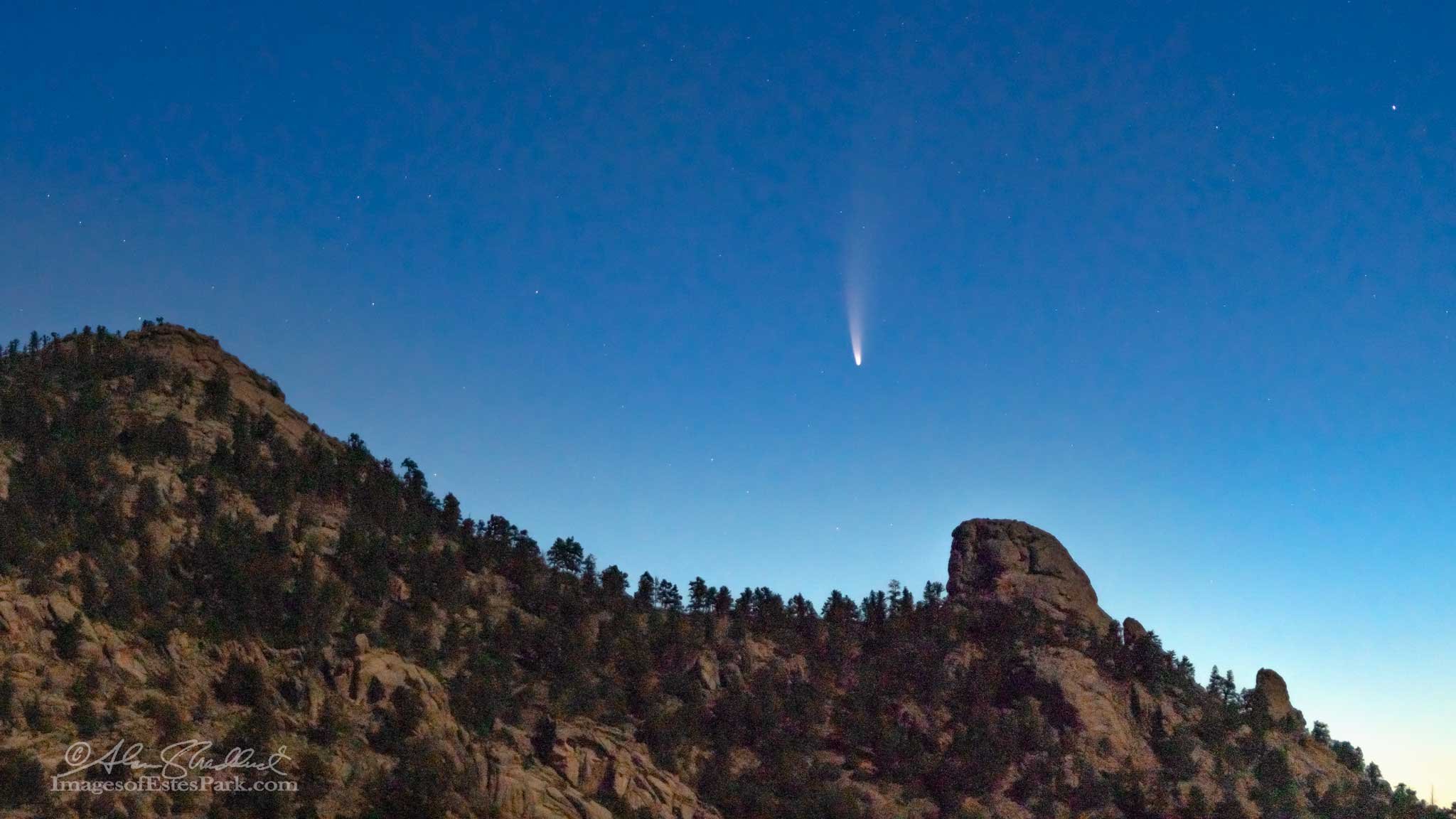
From a buddy up here in Estes of the comet Neowise. Photo was taken at 4:15am looking northeast, preceding the sun and roughly along the ecliptic. He reported that it is very naked eye visible, and noted that it was washed out by the sun around 4:45am.

-
1
-
-
56 minutes ago, mayjawintastawm said:
Good for you Chinook and ValpoVike! We are busting. Snow didn't begin till 6 AM and it snowed for 2+ hours accumulating 1 inch, then changed to freezing drizzle. What a difference a few miles makes!
Sorry to hear that! I am up to 18" now. Hoping to get to 20" before all is done. Then Spring
")
-
It is hard to get an accurate measurement with plenty of drifting, but I think around 12-13" overnight here. Not bad considering I went to bed last night with less than 1" on the ground. Now...bring on spring!
-
It has indeed been a pretty good year up in the foothills. Frankly, after this next storm I am hopeful that we are done.
-
On 4/7/2020 at 10:15 AM, mayjawintastawm said:
Long as it doesn't get below 20 it should be fine... the buds are starting to come out and it would be nice to see flowers and fruit, especially this year. We've had too many 15 degree mornings in April the past few years.
I actually saw a mosquito up here on my deck last night. That is super rare any time of the year.
-
2 hours ago, mayjawintastawm said:
Yes- I'm planning to find the places with the best takeout and hopefully help prevent them from closing when this $&&t really hits hard.
Up here in Estes there is a local campaign to buy gift certificates now from local restaurants.
-
1
-
Mountain West Discussion
in Central/Western States
Posted
The next 48 hours look to be really concerning for Red Feather Lakes. The northern portion of the fire has become quite active, and with the strong WSW winds tomorrow and Saturday it could be pretty bad. There are a lot of homes and cabins in that area.