
Thundersnow12
-
Posts
11,414 -
Joined
-
Last visited
Content Type
Profiles
Blogs
Forums
American Weather
Media Demo
Store
Gallery
Everything posted by Thundersnow12
-
Little step south for the graspers and those who need 2-5" along I-88 to verify.
-

Pre-Christmas (Dec 21-23rd) Winter Storm Part 2
Thundersnow12 replied to Chicago Storm's topic in Lakes/Ohio Valley
Pass -
Pre-Christmas (Dec 21-23rd) Winter Storm Part 2
Thundersnow12 replied to Chicago Storm's topic in Lakes/Ohio Valley
ORD vs DIA total is a good bet who gets more lol 3-5”ish for us later tonight with some post frontal jet banded snows. As temps crash below 0 -
Pre-Christmas (Dec 21-23rd) Winter Storm Part 2
Thundersnow12 replied to Chicago Storm's topic in Lakes/Ohio Valley
Is Alek still riding his 5” call for ORD? -
Pre-Christmas (Dec 21-23rd) Winter Storm
Thundersnow12 replied to Chicago Storm's topic in Lakes/Ohio Valley
Model trend gif courtesy of Thundersnow12 -
Pre-Christmas (Dec 21-23rd) Winter Storm
Thundersnow12 replied to Chicago Storm's topic in Lakes/Ohio Valley
Popping in for Alek’s first and final call -
0z weenie HRRR run for ORD. Nearly 1.25” of QPF. .
-
Fidel Castro. Yankees losing tonight coupled with early season cold gets the Napervillian cranky.
-
Spring 2022 Medium/Long Range Discussion
Thundersnow12 replied to Chicago Storm's topic in Lakes/Ohio Valley
Just go with whatever Joe thinks. Gospel -
Ride it
-
Nice step made on the 0z GFS.
-
HRRR with a random jackpot up there
-
Don't worry. Joe called the severe thunderstorm watch last night way overzealous and the entire CWA ends up seeing warnings and scattered 60-80mph gusts. Big L.
-
6z HRRR came in little juicer for Chi metro. Setting the stage for ISC to be too low again. Eek that guy. They should hire Alek
-
Cure my SE trend hangover event 2/21-2/22
Thundersnow12 replied to Baum's topic in Lakes/Ohio Valley
Yeah ice is awesome. -
KMDW 172314Z 34017KT 1/8SM R31C/2400V3000FT +SN FZFG VV007 M05/M07 A2990 RMK AO2 PK WND 35026/2255 DRSN P0001 T10501072
-
KORD 172251Z 35018G26KT 1/4SM R10L/2800V3500FT +SN VV008 M06/M09 A2991 RMK AO2 PK WND 01028/2154 SLP135 DRSN SNINCR 1/2 P0002 T10611089
-
3.1” total in Batavia and some of the heaviest snow I can remember. Has to be close to 2”/hr rates in that band
-
Yeah the King is back to being dead. RAP is the new hotness
-
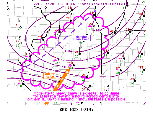
Mesoscale Discussion 0147 NWS Storm Prediction Center Norman OK 0317 PM CST Thu Feb 17 2022 Areas affected...portions of central into northern Illinois Concerning...Heavy snow Valid 172117Z - 172315Z SUMMARY...Moderate to occasionally heavy snow is expected to continue for at least a few more hours across central into northern Illinois. Up to 1 inch/hour snowfall rates are possible with the heaviest bands. DISCUSSION...KLOT and KILX dual-polarimetric radar data and surface observations have shown moderate to heavy snow falling across central into northern IL over the past few hours. While the 850 mb cyclone centered over the IL/IN continues to propagate northeast, away from the mid Mississippi Valley area, 20Z mesoanalysis continues to show modest 700 mb WAA and associated frontogenesis taking place across central into northern IL, where a saturated, sub-freezing troposphere is in place. The WAA and frontogenesis will continue to foster efficient dendrite growth within a southwest-northeast oriented snow band across central into northern IL for at least a few more hours, where moderate to heavy snow is expected. Up to 1 inch/hr snowfall rates may accompany stronger portions of the snow band. ..Squitieri.. 02/17/2022
-
Barb will be coming to a house near you
-
Was thinking the same given sfc temps in burbs
-
Snowing decently in Elburn
-
DVN radar actually looks p solid
-
15z RAP has to be absolute best weenie case for Chi metro. 4-6” from north to south. Been very consistent though since late last night showing 3-4”+ for the area

