Thundersnow12
-
Posts
11,414 -
Joined
-
Last visited
Content Type
Profiles
Blogs
Forums
American Weather
Media Demo
Store
Gallery
Everything posted by Thundersnow12
-
12/26/09
-

Jan 25-26th Potential Something Part 3
Thundersnow12 replied to Chicago Storm's topic in Lakes/Ohio Valley
HRRR continues to dry up here. Not good. 3” will be a win -
Joe says your LE thoughts are lol and can’t wait for GFS to verify
-
Poor Purdue
-
Geos magnet alive and well
-
Watching this one from afar in Colorado. Definitely a significant jump in the GEFS mean compared to last several runs on the MSLP/6hr precip plots.
-
NAM concerned. Joey not a fan
-
0z Euro tonight still looks decently solid so figured why not. Surface temps look marginal during most of the event but potential for a fairly juiced system overall (2.00"+ QPF over Cook county this run) and an area of some good snow amounts on the NW side looks possible. System of interest is still well out over the northern PAC and wont come ashore till Thursday evening.
-
Winter 2020-21 Medium/Long Range Discussion
Thundersnow12 replied to Hoosier's topic in Lakes/Ohio Valley
Mid 60s out here Tuesday. What a snoozer so far back home unfortunately -
Central/Western Medium-Long Range Discussion
Thundersnow12 replied to andyhb's topic in Central/Western States
No talk of tomorrow? ND looks good tomorrow and eyeing srn MN myself on Wednesday -
Central/Western Medium-Long Range Discussion
Thundersnow12 replied to andyhb's topic in Central/Western States
Victor Gensini and I have 5/14-5/25 blocked off for a trip to the plains, dependent on the pattern of course. -
Central/Western Medium-Long Range Discussion
Thundersnow12 replied to andyhb's topic in Central/Western States
Victor Gensini and I are leading trip 3 with COD and we are out June 2nd-June 11th. Both optimistic as things look currently. -
Central/Western Medium-Long Range Discussion
Thundersnow12 replied to andyhb's topic in Central/Western States
Departing Friday morning and probably chasing northeast/eastern NM on Saturday then some better days to follow across the plains. We'll see how the models shake out -
Central/Western Medium-Long Range Discussion
Thundersnow12 replied to andyhb's topic in Central/Western States
Leaving on CoD's trip 2 next Friday.. 12z op GFS run looks like it came around to the GEFS members idea the last several runs of a good trof signal by next weekend and the week beginning 5/16 along with a good EML being able to come out with an open Gulf. We will see how things shake out but I'm fairly optimistic -
Central/Western Medium-Long Range Discussion
Thundersnow12 replied to andyhb's topic in Central/Western States
Yeah the 12z Euro looks pretty nasty on Tuesday from srn KS to the Red River, dryline stays west of I-35 with 55kt flow at H5, upper 60 dews and 3,000-4,000 J/kg. -
Central/Western Medium-Long Range Discussion
Thundersnow12 replied to andyhb's topic in Central/Western States
Verbatim the 0z Euro looks quite good next Sun-Tues (day 7-9) more so Mon/Tues across the srn plains.. -
Central/Western Medium-Long Range Discussion
Thundersnow12 replied to andyhb's topic in Central/Western States
My second trip leaves Friday and after a little break of model watching, I finally looked this morning.. The 0z Euro and 6z GFS have me cautiously optimistic for some good chances across the nrn plains beginning as early as Monday possibly but hopefully getting even better just after that. -
Central/Western Medium-Long Range Discussion
Thundersnow12 replied to andyhb's topic in Central/Western States
Yep Victor and I have been loving Tueday down there. Anytime you get 60 dews in NM with solid shear, look out. We each have seen tornadoes on 5/19 in three different years -
Central/Western Medium-Long Range Discussion
Thundersnow12 replied to andyhb's topic in Central/Western States
Yeah GFS ensembles are trying to latch onto the next weekend trough, maybe Thur-Sat or Fri-Sun before Memorial day and the 12z op Euro has it too. -
Central/Western Medium-Long Range Discussion
Thundersnow12 replied to andyhb's topic in Central/Western States
The 0z Euro itself for Saturday does look pretty ominous even though it has the morning round convection, destabilizes behind into across north TX into western/sw OK with 4000 j/kg and dew points in the low 70's as that jet comes across. Our trip is probably going to leave very early Friday morning if something like the NAM ends up verifying for that afternoon/evening. -
Central/Western Medium-Long Range Discussion
Thundersnow12 replied to andyhb's topic in Central/Western States
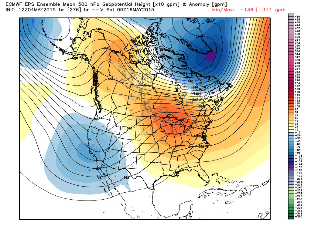
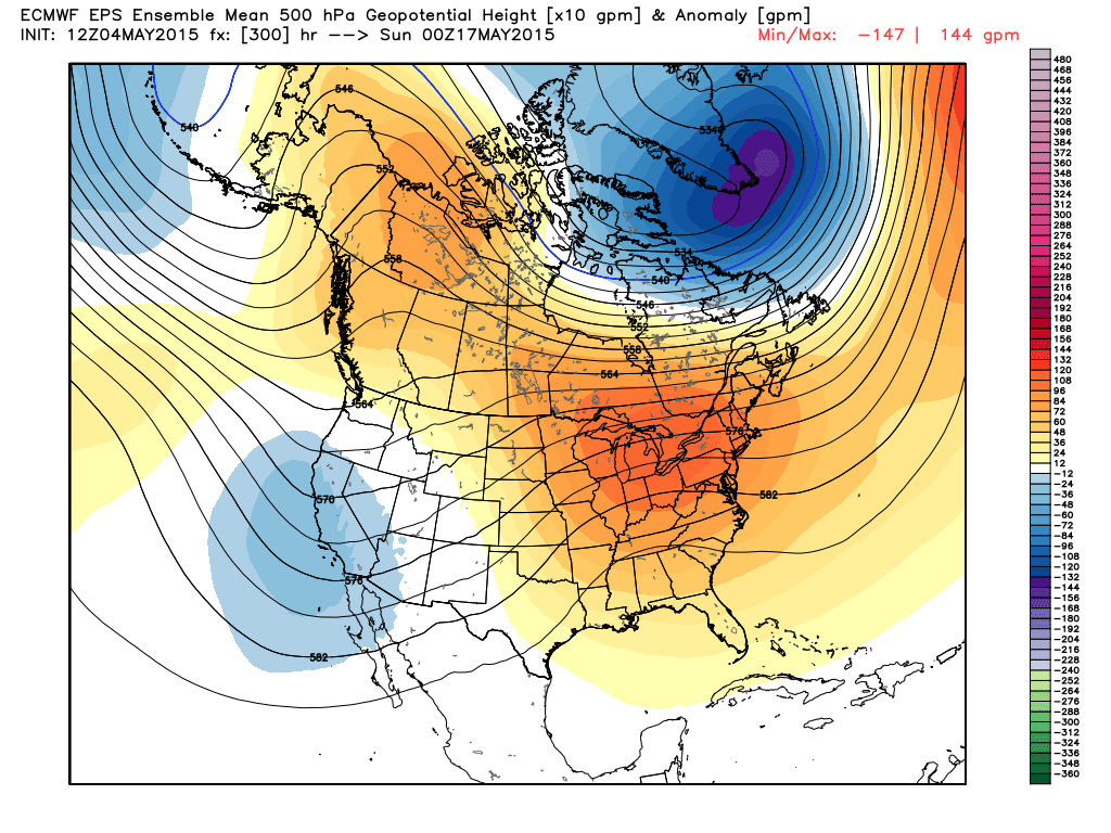
Yeah it really does look great beginning around 5/16 or a day after. The agreement continues to improve too. Loop the 0z GFS ensemble spaghetti plots on our CoD site. Good agreement right through day 9. The best thing is you get a good EML going during that period and the GOM just floods open as you keep reloading the west. -
Central/Western Medium-Long Range Discussion
Thundersnow12 replied to andyhb's topic in Central/Western States
-
Central/Western Medium-Long Range Discussion
Thundersnow12 replied to andyhb's topic in Central/Western States
Really impressive op GFS run tonight in la la land FWIW from about 5/17-5/21 and would continue after that. Finally a run which has been hinted at from ensembles. -
Central/Western Medium-Long Range Discussion
Thundersnow12 replied to andyhb's topic in Central/Western States
I'll be out again when you guys are out now as I'm also assisting Walker Ashley on CoD's trip 3 as well. -
Central/Western Medium-Long Range Discussion
Thundersnow12 replied to andyhb's topic in Central/Western States