

mississaugasnow
-
Posts
1,327 -
Joined
-
Last visited
Content Type
Profiles
Blogs
Forums
American Weather
Media Demo
Store
Gallery
Posts posted by mississaugasnow
-
-
5 minutes ago, michsnowfreak said:
2011-12 was the lowest snow season in my now 28 years of measuring snowfall. I finished with 25.5". It was certainly a terrible Winter but March was really the difference maker. Had it been even an average March the season would have blended in with just other subpar winters and not the stinker it is remembered for. While the final snowfall number is certainly what we all look at, a lot of other factors come in to play, like days with snow on the ground, how deep did the snow get at its deepest, what was the biggest storm, how cold, etc. I'm at 19.8" so far so technically I could still fall below 2011-12 but there really is a long way to go. Plus I've had a bigger storms and more days with snow on the ground than in 2011-12.
Ya, Toronto is already around 26" so even just a bit more will make it look like just a slightly bad winter in the record books. Im thinking Toronto has one more legit winter storm of 4-8" and a few more slop 1-3, 2-4" type events. I think Toronto ends up right around 36" on the season. About 4-6" below normal.
-
 2
2
-
-
27 minutes ago, Stevo6899 said:
6+ nov snows are pretty rare even tho we had one in the past 5 or so years. Always temp issues, warm ground, etc. And yea it can snow in March but it's been so long since we had a good march snowstorm so legit and most of our good snows happen in the 3 main months.
ya, I've been looking at a lot of historical weather for Toronto and March and April the last decade have been very similar. 1-5" falls. They've become near identical in snowfall. But Toronto hasn't seen a snowstorm over 4" in the last decade after March 1st. March and April at least for Toronto has been pretty bad
-
1 hour ago, michsnowfreak said:
I totally understand as we always say, different strokes were different folks. Not sure if you're counting 2017-18 or not, but that was a good snowy winter. Since then it's been much more "average" overall but February 21 was definitely a good month to see deep snow and we did have an 11" snow storm. But again regarding beavis I would bet my last dollar that if you offered him a Winter with 80" of snow including 2 storms over a foot but constant thaws/torches leaving more bare ground than snow...or a Winter with 35" of snow, constant cold and no bare ground the entire Winter he would take the latter in a heartbeat.
It's been a pretty cold week but we are gonna warm up this week. I got some tears while walking in the park yesterday due to the cold. But that's after being out for prolonged period. Just stepping in-and-out even the bitterest cold doesn't bother me at all.
Yep, snow cover for me. Thats why Im down to about 4ish weeks left of cheering for winter. After that unless it's an absolute monster 12" storm I want 40s-50s and spring haha. I know climo says enjoy 2-4" of wet snow followed by 38F and cloudy in mid March-early April but those just really annoy me haha.
-
2
-
-
On 1/5/2023 at 4:19 PM, hardypalmguy said:
This is ideal winter. Could be a bit warmer though.
when do you put your palms back out? My banana and windmill palm are inside but I was able to keep them out until mid November.
-
19 hours ago, michsnowfreak said:
That's a very valid point about snow. But also, if you're cold and not getting a lot of snow, people often still refer to it is mild. The last 2 years were not mild winters in the Midwest.
Regarding warming over the last 100 years, it depends on location but clearly the East Coast is warming more than the lower Midwest. In fact, the lower Great Lakes show minimal warming although I suspect Chicago's cooling trend is due to location change.
Detroit warmed 0.9°
Cleveland warmed 0.6°
Toledo stayed exactly the same
Columbus warmed 0.1°
Indianapolis cooled 0.1°
Chicago cooled 1.3°
Milwaukee warmed 2.0°
Minneapolis warmed 2.6°
New york city warmed 3.2°
Boston warmed 2.6°
Buffalo warmed 1.5°
Wash DC warmed 2.8°
Burlington VT warmed 4.4°
Thats interesting. I wonder why from pretty much Southern Ontario eastward has warmed, skips Ohio, Michigan, Illinois and resumes again in Wisconsin and Minnesota.
-
1
-
-
9 hours ago, Torchageddon said:
I waited for this thing to start cranking and it did slowly ramp up throughout most of the day til 8 pm but overall this was a big bust and I'm not impressed lol. At no point did I witness any blizzard conditions as forecast for my town and my winds never made it high enough. This is NOTHING like Jan 6 2014, it barely stands out but I would consider it a solid winter storm; I was expecting the basement to be a major winter storm and I don't know if I can even call this that by Christmas Day. The main issues are the same as written above, flake size far too small due to strong winds and lack of moisture. My temp got down to -11.6C and then stabilized with a wind chill of -22C. I doubt I got 40cm (for Fri) as thought - probably 20cm with drifts. The LES mode was totally different from what I expected and never got in the mod returns like the shoreline did and there isn't any bands near me like Parry Sound and Buffalo has. I don't know why my winds were crap other than the orientation but still with the strength of this low it shouldn't have been this zzzz. By 10:30pm the flizzard started winding down when earlier I expected raging blizzard status and a double dip for Eve which my hourlies still show bizz for 8+ hours later on
 .
.
Amazing that Hamilton got blizz but not me, that's a twist. There is some magic going on near Lake Erie and Ontario for sure in this storm.
I did notice areas way south were much colder than me like London and Windsor ON got windchills of -28 to -32 whereas I'm getting -22. Same with air temps.
ya the storm was a weird one and was more local and persons history of storms. Ive only lived in inner GTA until 5 years ago and now live in rural Ontario so for me this was my first actual blizzard.
I also think media and general population is quick to put emotions into weather. Muskoka laughs at GTA winter storms saying Toronto is weak and in summer its Toronto laughing at Muskoka and Northern Ontario complain about average heat waves. 40-45C happens every summer in Toronto with nights staying above 21C but in Parry Sound, Sudbury, Timmins its all anyone would talk about (I work all over Ontario)
Ontario almost has the exact same dynamic as northern states vs southern states in regards to winter and summer weather haha
-
2
-
-
ended up being the best snowstorm I've ever experienced. Not often I see actual blizzard conditions.
-
3
-
-
16 minutes ago, Frog Town said:
Nail in the coffin for the NW Ohio/SE Mich peeps...sorry.
.NEAR TERM /THROUGH FRIDAY NIGHT/...
Latest radar, 0z model guidance, and surface observations
suggest that we are perhaps entering a perceived "lull" in the
precipitation along the arctic front, especially across NW OH
this evening as the upper-jet energy begins to arrive across the
Lower OH Valley which will lead to explosive cyclogenesis late
tonight into Friday. This may lead to lower snowfall totals and
overall impacts across NW OH. However, we are currently watching
an area of precipitation across SW OH that continues to
strengthen, noted by multiple surface observations of moderate
to heavy snow at times. This area of precipitation will work its
way north and east into the region later tonight in conjunction
with the strong, arctic front. This will be the area to watch
for any significant impacts with regards to snowfall rates
and/or blowing snow overnight and into the morning hours.
yikes.
-
Just now, RogueWaves said:
Happy for ya guy, ride it over there!
Toronto and GTA feel most of the forums pain. Unlikely to do much snow wise but hopefully winds make up for it
-
1
-
-
4 minutes ago, josh_4184 said:
Yea, or at least the most impacted areas. To bad the GOM tap was cutoff or this thing could have been beyond crazy for the whole sub.
the eastern half was walking a fine line. Not sure if GOM was feeding moisture Detroit eastwards would be getting much snow
-
 1
1
-
-
5 minutes ago, sbnwx85 said:
Based on social media comments on my station's pages, people aren't quite grasping the seriousness of this. They're getting caught up on snow amounts, most saying it won't be that bad. I'm sure many are going to push it to make it home for Christmas. It's going to be a long weekend for first responders.
same thing here in Ontario
-
13 minutes ago, Torchageddon said:

From TWN. That 50-75 contour is incredible and I'm smack in the middle of it. Sorry Toronto however I don't buy one bit into maps like this and it was a snapshot from this morning.
I'll take my 10-20cm and run.
-
1
-
-
45 minutes ago, JustMePatrick said:
The Wind for those of us in Ohio/MI will be insane.
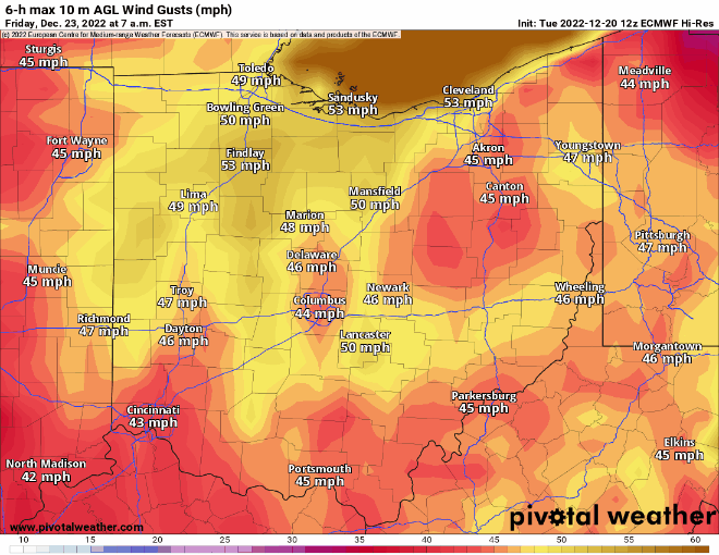
check out the north shore of Lake Erie on that run. 70-75mph showing up
-
18 minutes ago, Stevo6899 said:
Track what? lol. Ain't nothing to track when you're east of the low. I wouldn't bank on wrap around precip either. But hey i guess if you love weather, it could be fun to track others' snowstorms.
Parts of Southern Ontario and WNY look decent on the east side.
-
Environment Canada came out with a pretty strong statement. They don't normally put out special weather statements 4 days in advance
Significant winter storm expected late this week into the holiday weekend.
Precipitation may begin as rain or snow late Thursday before possibly transitioning to rain in many areas early Friday. Temperatures are expected to plummet on Friday leading to a potential flash freeze for locations that receive rainfall. Rapidly falling temperatures will be accompanied by strong to potentially damaging winds along with snow that may be heavy at times. Blizzard conditions are possible late Friday into the weekend for areas downwind of Lake Huron and Georgian Bay.
A multi-day lake effect snow event is expected into the weekend in the wake of the system for locations east of the Great Lakes.
While there is high confidence in a high impact winter storm, the details regarding wind speeds, precipitation types and amounts remain highly uncertain at this time. Please monitor your local forecast and the latest alerts for your area.
Consider altering plans through the holiday weekend as travel conditions may become dangerous. Extensive utility outages are possible. Temperatures Friday night into the weekend will likely be the coldest of the season to date.
-
1
-
-
16 minutes ago, Powerball said:
FWIW, the 12z EURO and GGEM would still be a decent event (4-6" with blizzard conditions).
That's not too bad, especially in time for Christmas.
Over here in the GTA I would take 2-5" with 50mph gusts every day.
-
1
-
-
On 12/12/2022 at 4:24 PM, hardypalmguy said:
cold won't verify.
Pretty bad start to winter for the Great Lakes. The cold and snow keep getting pushed back so its not the worst call haha
-
 1
1
-
-
Canadian side of Lake Erie getting some of the highest amounts Ive seen in a while. 15-60cm from Long Point ON-Fort Erie ON.
Discussion:
An intense snow squall is expected to develop over Lake Erie tonight and may impact parts of Long Point through Friday before lifting northward toward the remainder of the Lake Erie shoreline on Saturday. At this time, the highest accumulations are most likely over Long Point.Kincardine-Owen Sound-Parry Sound off Lake Huron and Georgian Bay looking at 30-60cm
-
2
-
-
1 minute ago, AmericanWxFreak said:
Is it correct that the surge for Punta Gorda is still inbound once the winds shift with the other side of the eye wall?
I’ve been wondering as well. Port Charlotte got some bad winds but may miss the 12-18 foot surge
-
Gasparilla Island, 125mph
-
10 minutes ago, hooralph said:
Is this the thread where we complain about family members in the path who won't evacuate?
My father-in-law is at ground zero - on a canal off Port Charlotte harbor...
My in-laws place is right by El Jobean bridge. They aren't there but the house is in the red evacuate zone. Do you know if a lot of the area is staying?
This will be one of the first storms I track where family property is on the line.
-
4 minutes ago, beanskip said:
What’s missing about the Charley comparisons is the potential for storm surge in Charlotte Harbor. The main part of the harbor was on the left side of Charley, which passed over Captiva Island. A storm that makes landfall at, say, Englewood or Stump Pass, to the north, would drive water through Boca Grande Pass and right up into the harbor. I would think that narrow pass would be overwhelmed causing big issues on Gasparilla Island as well.
Yep, my in laws have a place right on the water in Port Charlotte. They've been busy the last few days trying to coordinate from Canada.
-
1
-
-
Any guesses when the region sees it first widespread frost? Only 3 weeks from now on average and decent chunk of Southern Ontario (Muskoka, Orangeville, Eastern Ontario) can easily see 30s for nighttime lows.
-
3 hours ago, brentrich said:
And no 90's in sight for next 2 weeks, what a bunch of trolls in this forum. We have not hit 90 degree yet this year and it's almost July.
Lol I’ve already pointed out numerous times Toronto has hit 90F. I also sent you an article awhile back where it confirmed September 2021 was above average.
Anyways in 6 weeks I’ll start growing tired of summer and want fall. If it’s not 55 and sunny with frost every day in late august I’ll be pretty upset since you seem to be promising me an endless supply of way below average weather haha
-
 1
1
-
March 3-4 Potential Winter Storm
in Lakes/Ohio Valley
Posted
Interesting that EC and NWS have vastly different forecasts for Windsor-Detroit area. Windsor is heavy rain tomorrow with half an inch of rain or more changing to snow but only 2". No warning, just a special weather statement. The other side of the river is winter storm warning for 6-10"