

tavwtby
-
Posts
2,259 -
Joined
-
Last visited
Content Type
Profiles
Blogs
Forums
American Weather
Media Demo
Store
Gallery
Posts posted by tavwtby
-
-
looks like a good thump on the nam
-
man it's cold out there, gusty NW winds going right through ya...
-
 3
3
-
-
17 minutes ago, 40/70 Benchmark said:
You can hear CT and RI willing the NAM to competency.
yeah, willing, but sticking with 4-8 regardless unless I see all agreement inside 24
-
1
-
-
-
nice H7 fronto through CT on this run, looks a little more amped to me too
-
17 minutes ago, Sey-Mour Snow said:
Definitely parts of Ct and probably se New England
I don't recall any WSW last year, I could be wrong though not something I keep archives on
-
30 minutes ago, Sey-Mour Snow said:

25 mile tick NW with the goods also not as impressive with the Sunday stuff .. just noise at this point will waffle back and forth til go time..ooo... I like that one, lock it up!
-
 1
1
-
-
ALY hoisted Watch for here with 8-12" pretty much for the forecast area outside of Aly west, and SVT, but if things keep trending SE, or a later phase, we're still looking at 4-8 here for my area, unless the midlvl magic happens, have to watch the H7 vort, thinking the same as everyone else, SEMA and pts Metro West jack with this one..
-
1
-
-
nearly a half inch out there overnight, good primer for upcoming...
-
Just now, The 4 Seasons said:
First call. 3 days out, confidence is average. Probably gonna change for final on Friday but this what we're thinking ATM. Confidence is much lower around NYC/LI/NJ but thats not a concern for this forum, probably gonna have to tighten up that gradient-ha


looks about in line with current guidance and trends, would love more but will take a half footer all day these days...
-
2
-
-
looked like 4-8 imby yesterday, and leading up to that, going to stick with that for now, man it is just nice to have something relevant to track and seeing the forum pages deep from just a couple hours tells you something! enjoy the track and snow folks!
-
1
-
 1
1
-
-
I was just going to say, is this even on land and being sampled better yet? and those off hour runs always tend to loose it some, I'm waiting for the 48" nam run to spit
-
3
-
-
2 hours ago, H2Otown_WX said:
Well happy early birthday fellow (former) Waterburyian
thx!
-
1
-
-
45 minutes ago, H2Otown_WX said:
Wasn't 1/3/06 paste? Maybe not in your area...
I think 1/3/06 was graupel and sleet, with some paste, only reason I remember is cause it's my birthday, always take something on my birthday... not sure what it did further north tho, I was still in Waterbury at the time.
-
3 hours ago, NotSureWeather said:
Imagine being so angry that you need to take it out on strangers in a weather forum. Should be grateful we get to even track something.
I'm saying that to myself, honestly a good dumping I thought would lighten the mood, or at least some sigs to track would, but honestly some people just need to bitch and complain about stuff and it won't stop, if we got a 3' KU region wide, ppl be bitching about a 384 hr warm up, it's incredible. it's NYE, things are active and some potential is there, we still have two honest winter months and another that can produce, let's take it down a notch with the cortisol...
-
1
-
-
5 minutes ago, DavisStraight said:
This would be ok if it works out

that'll work, hope I get to see something otg before I drive south until mid February.
-
26 minutes ago, kazimirkai said:
Jesus where are all the fun colors? So unappealing lol
black and white clown maps just didn't have the dopamine, however the skill involved in these awe me, miss those old weather prognosticators and their maps and explanation
-
1
-
-
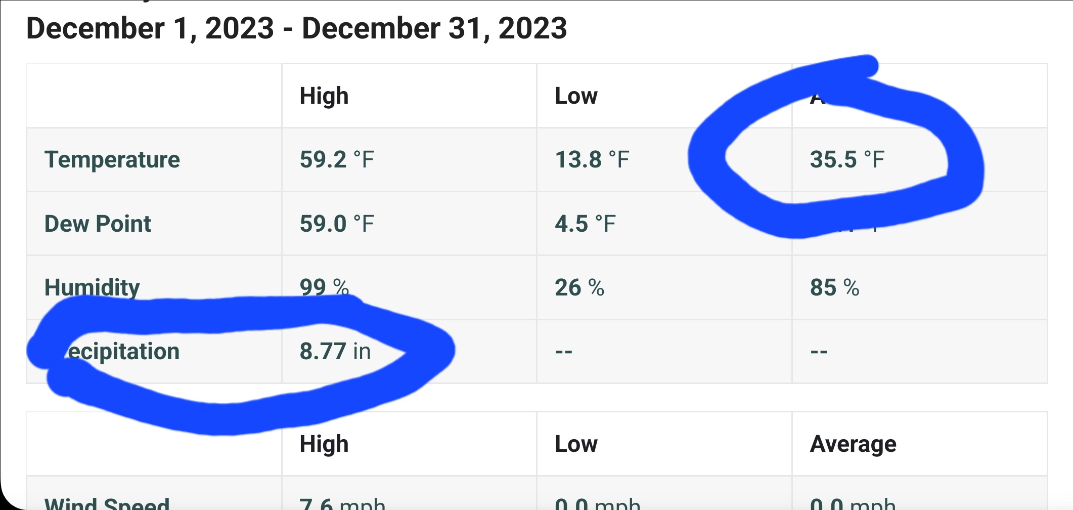
finishing Dec off with a bang huh, nearly 9" of rain, avg mean temp 35.5...and it's still raining, I'll have to check the archives on how this ranks in terms of Dec rain, that's even a lot of precip let alone RN only..

-
1
-
-
1 hour ago, 512high said:
Tip, I'm really confused with all the model runs the last few days I think it was you and others a few days ago or so, "sniff" something to watch around 1/5, then, and I could be wrong, I thought I read somewhere pages back, that the 1/5 was gone, and now a possible 1/8 or 1/9, another words did 1/5 disappear this am, and is now popping up ? What is going on with models, or is shit just moving too fast, seems a lot of clutter...
1/4-1/10 was always showing up as a shot at something, sigs popping up and disappearing, but unfortunately we don't have cold source until maybe the second of them and that looked suppressed to me, still time though for either of these, and how those waves will effect each other a nice phase with a good HP in S Quebec would be great to lighten moods and bring some from the cliff about now, maybe even stop the cancellation of winter on 12/29...
-
1
-
1
-
-
3 minutes ago, WxWatcher007 said:
Retention matters little to me here in the valley. For me, total snowfall, frequency of events, impact of events, and novelty of events (for example the big cold in February) hold significant weight in a seasonal grade.
I agree with the retention, doesn't matter to me, it gets stale if not refreshed by new snows...I personally prefer frequent snows at least one good cold stretch and total snowfall.
-
so for those who put a grade on winter, other than retention, what are the other categories that factor in? frequency, cold, snow depth, total snowfall? just curious.
-
40 minutes ago, Ginx snewx said:
Kevin was in heaven 10/11 14/15 12/13 all second half winters, he ain't fooling anyone.
I'll take 10/11 or 12/13 walking through the door, 14/15 was ok, but was better in eastern areas than here, by the Feb 2 storm of2011 I had about 35-40" on my roof! that was the most snow I think I saw otg, and had to dig out a path for the oil delivery and by the time I got to the road it was as tall as me and like looking at fossils, seeing the layers of different storms, that was cool. historically speaking, the majority of our best storms happen from mid January to mid February, with some outliers but that's always the most active period in my experience.
-
26 minutes ago, 40/70 Benchmark said:
1995-1996.
I think that's the only one in my lifetime that went wire to wire snowstorms, and iirc, we had a pretty good thaw in mid January after the blizzard, maybe 2002-2003 was another? one of those winters was pretty good start to finish in early oughts
-
33 minutes ago, WinterWolf said:
It did produce…but only for HUBB Dave and Ineedsnow. Lol.
yeah, lot of us in WSNE got skunked last winter while a lot were able to at least get near avg. I wound up with 41.25" 3rd worst of the last 5 years if you can believe that.
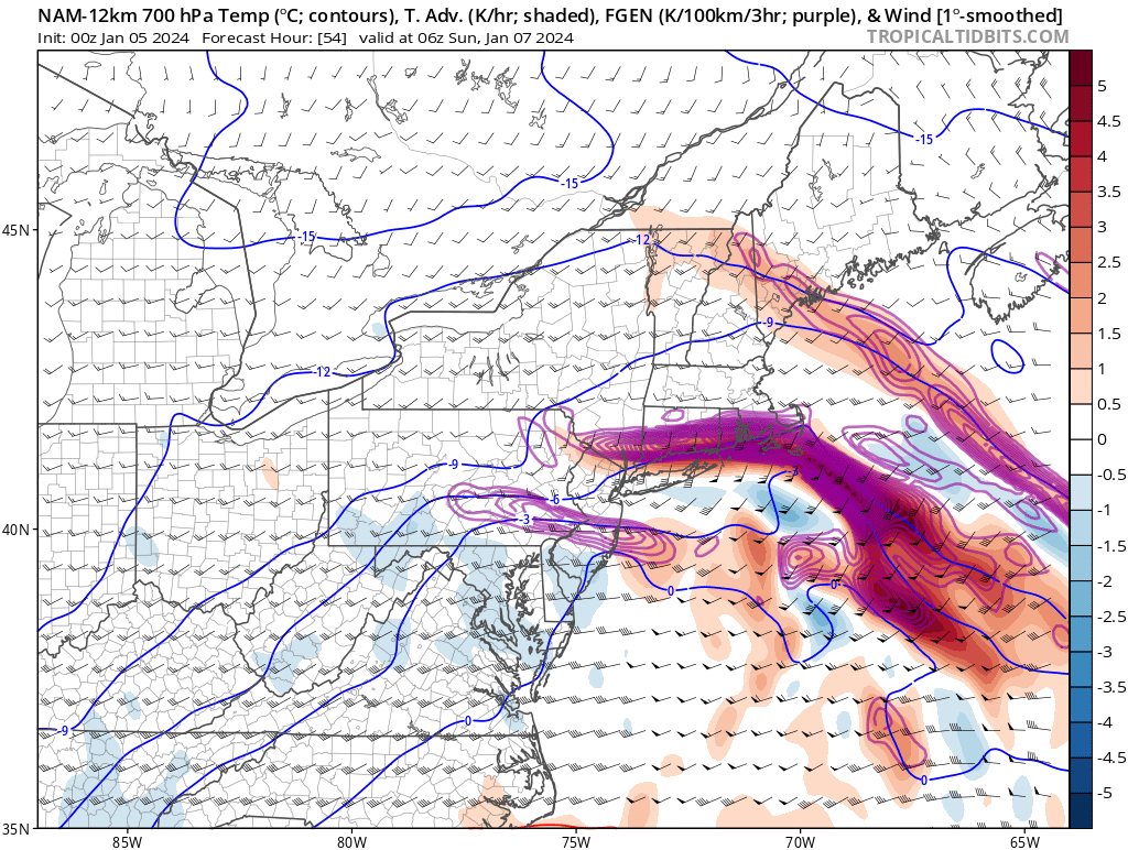


Monitoring first regional significant winter impact event. Magnitude likely tempered. At this time NE PA/SE NY and SNE primarily. Jan 7/8.
in New England
Posted
8-12 with lollies to 14 region wide?