

tavwtby
-
Posts
2,259 -
Joined
-
Last visited
Content Type
Profiles
Blogs
Forums
American Weather
Media Demo
Store
Gallery
Posts posted by tavwtby
-
-
8 minutes ago, 40/70 Benchmark said:
Its a better storm overall with more N stream insert, but its just that the very best shifted north.
we don't want too much more N stream interaction though, could really cause some issues, no? bring it north, but possibly slow it some?
-
looks like a good band from say dxr up to orh, could see some nice lollies in there somewhere where it goes to town with rates... although does appear in line with H7, shouldn't the best lift be just NW of that? that would put it in Berks to SNH
-
 1
1
-
-
it'd be nice to have the airmass that follows this system in place before it gets here for a change, looks like another toe the line temp system, and it's moving, so ceiling ain't too high here, maybe a bit east up through ORH will be better, ALY is weary with pops at this time, don't blame em, within 4 days and still very flip floppy, at least something is there to track...
-
1
-
-
My second all time favorite storm, 78 still holds the top spot because as a kid it was like a crippler for a week, but 2013 I owned a house in Waterbury and was awake almost the whole night, filming and watching the incredible band rotating through...my avatar is that, most intense snow I've ever seen
-
1 minute ago, Ginx snewx said:

seriously starting to think that op is working, this one is everywhere!
-
2 minutes ago, AstronomyEnjoyer said:
Nope!
it's crazy though, what are the odds, he works Flight controls MEFP mainly JSF, at Edwards and PAX, for us and has the same hobbies...if you used to be there, you probably know him
-
4 minutes ago, AstronomyEnjoyer said:
I wish, still hold a TS clearance.
Zach?? I know a guy who has clearance, used to work at Edwards and is into astronomy and photography, very coincidental.
-
4 hours ago, wxsniss said:
For any newcomers looking for great summaries of climate data including monthly / seasonal snowfall:
http://climod2.nrcc.cornell.edu/
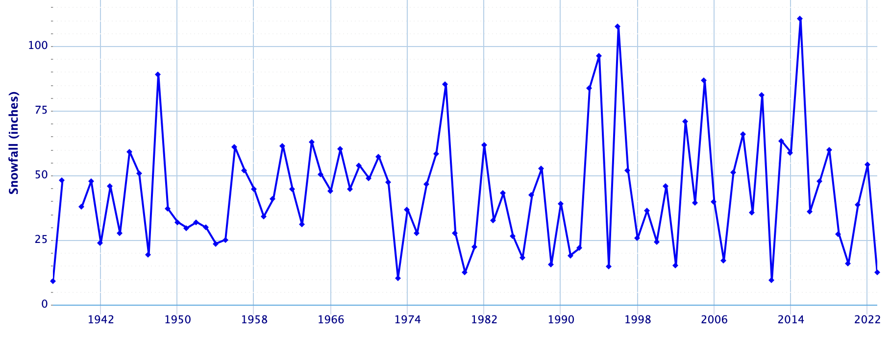
Quick eyeball: 1957-58 had one of the best turnaround of snowfalls for KBOS: 6.7" Nov-Jan, then 38" Feb-April. I'm curious what teleconnectors were at play in the switch if anyone knows.
Also, not a formal statistical analysis, but the most prominent trend is just all the higher maxima beginning 1992-93 (incidentally, the year I arrived in Boston, skewing my expectations forever
") ):
):
Seasonal snowfall for KBOS:
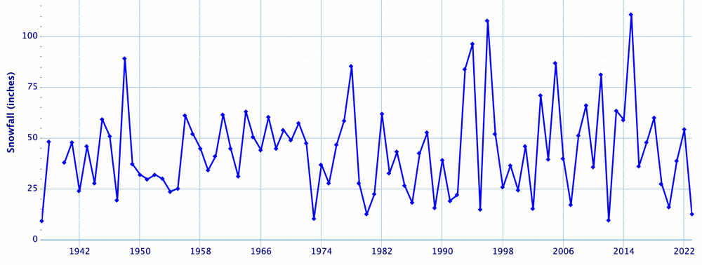
if you go through most of the years, at least for my closest stations, the majority of the snowfall happened from late January to April 1st, the great winters did have a good Dec/Jan... and even some Nov snows, but just at the dozen or so I've looked at, I'd say 70% of the season snowfall happened after 2/1... not saying that'll happen here, but it is a trend... now I've got another project to do, seeing how much fell post 1/31 as a percentage of season snowfall.... that'll be interesting
-
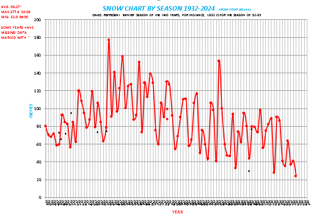
Definitely 50's to early 70's was a great run on winters...I am slowly working on going back to 1878, since discovering some new data, and also working on some temp trends as well as precip.
-
2
-
 2
2
-
-
looks like 30s/40s and basically nothing for a couple weeks, unless something changes, but around Vday looks interesting, but that is a long way out
-
2 hours ago, The 4 Seasons said:
If anyone has any final totals from CT, MA, RI let me know. I got a feeling that additional 1-2/1-3 was probably more like C-1.

total from event, 2.8...it snowed fairly well from about 1800 yesterday to now, still snowing... and it basically melted or sublimated as fast as it fell, so only about a half inch since then...if it was a little colder we'd probably have about 6 out there
-
and just like that it's ripping again, nice band filled in west and moved in
-
1
-
-
kinda wishing I went and cleaned the snow before, looks like this is petering out, radar meh, snowing nonetheless but doubt it amounts to anything significant
-
3 minutes ago, FXWX said:
Lots of lingering moisture with enough lift to keep occasional light snow and additional coatings into predawn hours. Common for Litchfield cty to see these things linger even with poor radar presentation. Drives DPW crews up there crazy across the county since it forces retreatments and the occasional scraping. Most crews will call it quits soon and then come back in prior to bus runs in the morning...
yeah I have a couple buddies work for CT DOT, and they are actually itching for this, that OT they used to get with big storms has dried up a lot last few years, and some used to bitch about it until it wasn't there.. speaking of calling it quits, Winchester DPW hasn't been out since about 3, my road has a couple inches on it, and 8/44 are also covered
-
1
-
-
1 minute ago, wxeyeNH said:
Time sensitive. Friends just called me from Sturbridge on the Mass Pike. Heavy snow with many accidents. Road is slush covered and extremely slippery. I was actually surprised how bad they said it was. They were coming from NYC and said the north part of RT 84 was bad to but now they are thinking of getting a hotel instead of continuing east to their home in Boston.
that area of 84 is always a mess in storms, I remember coming home from Danvers once and there were cars all over the place from the old toll plaza to the blue is treacherous during storms
-
1
-
-
I say a couple more hours here then it's done, can already see the echoes west diminishing as the primary coastal takes over, here relies on the front end with these systems, while eor folks get into the CCB and round 2 stuff good
-
excellent snowball material here... just saying
-
back to all snow now awt as soon as the sun went down, hopefully that out west can pivot and maintain to pick up a few more, or couple more anyway...
-
well it's pinging to beat the band here, oh so close to the goods, occasional flakes mixed in... debating on to clean, or wait for what's west to come through
-
5 minutes ago, Damage In Tolland said:
The whole commahead will fill and rotate thru even down to S CT after 6:00 or so . Easily another 1-3”
hopefully, don't have high confidence iin that happening...usually that peeters out during the transfer to the main coastal, unless it is really amped
-
just took a trip to west Springfield and Enfield, nearly nada, but the hill on 219 going was sketchy, just pingers and drizzle now with occasional burst of flakes...2.2" before we slotted not sure if what's out west will do anything here unless it goes to town, because them lighter echoes are drizzle and IP
-
puking flakes right now, under 1/4 vis, insane and closing in on 2" quickly... eyeballing 1.5+
-
1
-
-
sirens everywhere, roads must be a mess here, been covered for a while now, no treatment and what was on the road washed the other day, so not good..
-
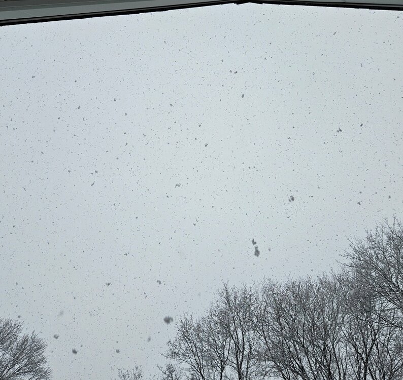
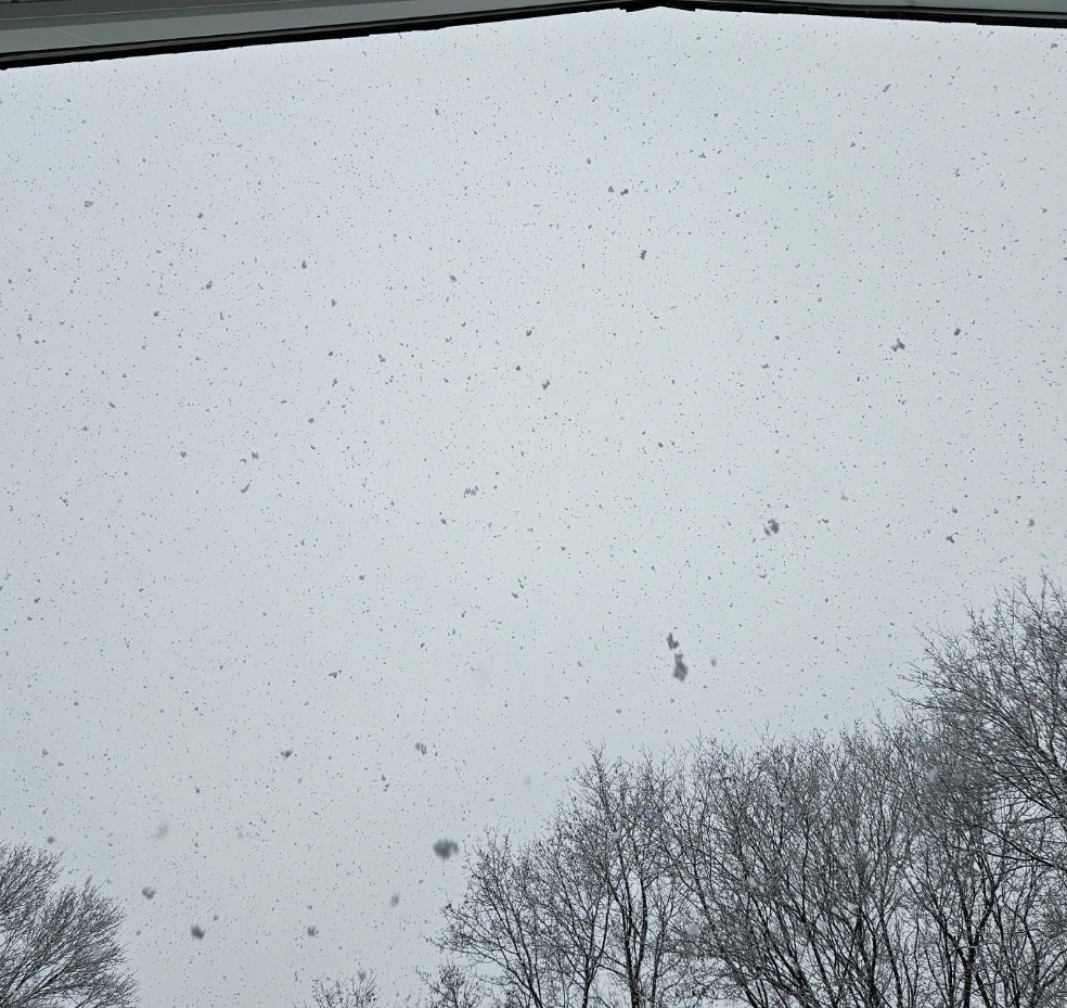
just about an inch of paws otg, tried to get a shot up as they are falling, it's crazy how big they were at one point, still big but not clumps of snow
-
3
-


Following a Miller A/B hybrid type coastal potential, Feb 13th ... As yet untapped potential and a higher ceiling with this one
in New England
Posted
what's causing the north tics, confluence weakening or the N stream pulling and phasing more?