

tavwtby
-
Posts
2,814 -
Joined
-
Last visited
Content Type
Profiles
Blogs
Forums
American Weather
Media Demo
Store
Gallery
Posts posted by tavwtby
-
-
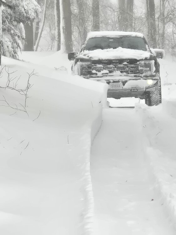
this is some pile up quick stuff, about 1.5 maybe a bit more eyeballing, measure when it stops
-
@The 4 Seasons, not sure if I told you, but couple friends in Warren and Goshen both measured, 13" and 14.7" respectively, I see a 6" total that looks like it's about Northfield area, and I can say personally I saw way more than that unless they forgot to update, but it's out of place, and mine is 15.2" not sure who recorded the 15.6, but like I said, I'll take the extra stat pad. Couple of coaches I know in New Milford were both over 19" but map already shows it. just an update for the archives.
-
 1
1
-
-
let's go to mid March with a bang, then need to get some melting so garden work can begin! still a ways a way but like the trend so far.

-
 1
1
-
-
1 minute ago, The 4 Seasons said:
yeah 2011 was a canal runner
minus a few 17/18 that was a WoR 20+ event, I remember I had a job interview I had to reschedule because of this, all good tho both ways worked out.
-
30 minutes ago, The 4 Seasons said:
i dont wanna think about it
we're better off with a canal runner or just between ACK and the coast to get what happened yesterday, WoR...
-
1
-
-
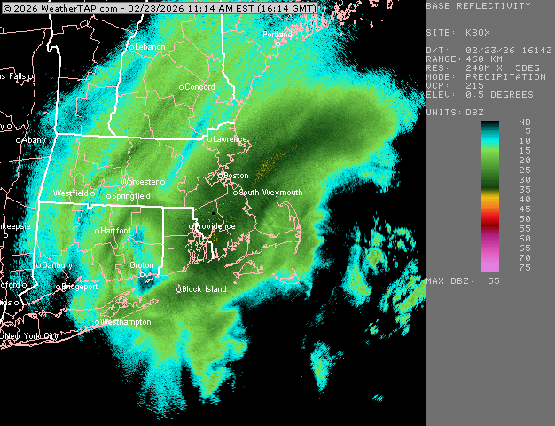
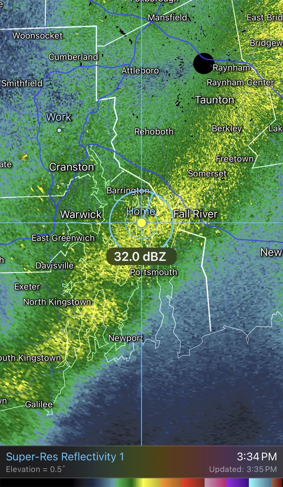
so I went into the office today, across the street from BDL, and on the way in you could see where that secondary band kinda cut off in western Granby, going up the hill in barkhamsted it was looking like here, also had to go to Waterbury today and just south of about harwinton it seemed a bit less, but Waterbury looks like maybe 12/13" fell, I assume from the initial push, that fizzled out overnight, then the banding took over around predawn time
-
13 minutes ago, OceanStWx said:
In a typical developing (i.e. not peak intensity) storm your frontogenesis is going to be sloped towards the cold air. 850 is farther southeast than 700 mb, and so on. Lift tends to be maximized around 700 mb, hence congrats Dendrite.
This storm bombed out a little farther south, so one of the first things I noticed was the position of the forecast 700 and 850 mb frontogenesis.


While still sloped a bit, it's far more collocated/vertically stacked. That signaled to me that one major band would develop. And that look at 700 mb with a secondary band farther north suggested to me that it wasn't going to be a uniform precip shield. That a subsidence zone was possible between the two. I may have sent a text about toaster baths in the LWM area to @CoastalWx and @CT Rain Sunday.
I made a little gif too, so you can see how the forcing is overlaid.

I do think part of the problem with the secondary band was that it was advecting so much dry air into the storm. @dendrite posted somewhere along the line the map of RH, and 50% across central NH just wasn't going to get it done for that northern extent. It was like a dry wedge in the usually CAD spots.
nice analysis, would explain why my area down to about DXR was seeing on and off SN+ while 15-20mi east of me was light snow, it really ripped here for a good part of yesterday morning, then would wave on and off as the dry air was trying to push east as it moved... but that band down there was relentless with the rates good Lord!
-
2 minutes ago, Damage In Tolland said:
I can only imagine the damage those things have done here. I’ve been battling for a few years. Kill em all
those things are assholes, between them, the chipmunks eating my berries, and the rats that somehow always migrate from disgusting neighbors house to feed at the coop, we're constantly chasing critters out... looks good weather wise going into March tho huh! if next week transpires, it can go right to 70s for all I care. been a decent winter, best since 14/15 here.
-
 1
1
-
-
anyone know what the pressure got to bottom at and was it anywhere close to record deepening? I don't recall these stats, I thought hurricane Gloria was the fastest mb drop or a west Atlantic storm but I could have that incorrect.
-
2 minutes ago, andyhb said:
https://mesonet.agron.iastate.edu/wx/afos/p.php?pil=RERPVD&e=202602240000
37.9 inches at PVD!!
wow, they blew past that record huh, can't imagine that being surpassed in my life, it's held for almost 40 years, and now it's an insane total, what a storm for them, fairly well modeled with that area getting the goods
-
19 minutes ago, WinterWolf said:
@The 4 Seasons….so I measured the best I could, and got 13”. On the news tonight channel 3 Eye witness news said southington had 15”….so you can use either one pal.
@The 4 SeasonsI tried to send you a message but it said you couldn't receive them? anyway there's a 15.6 ob on the NWS site and mine was 15.2, use whichever in this instance as well, also I'm about 71" on the season, haven't updated the forum total in a while
-
2
-
-
9 minutes ago, ScituateMA said:
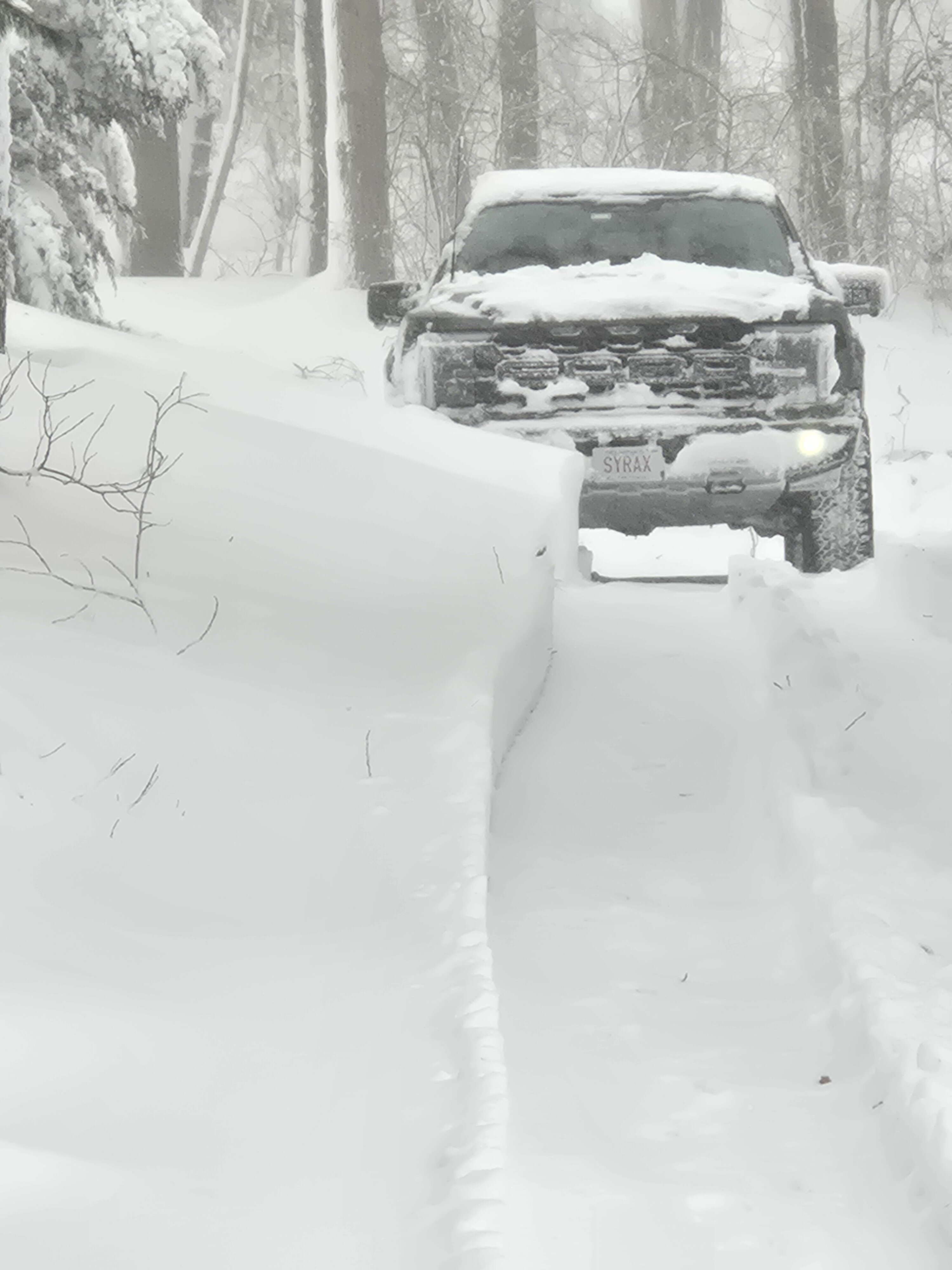
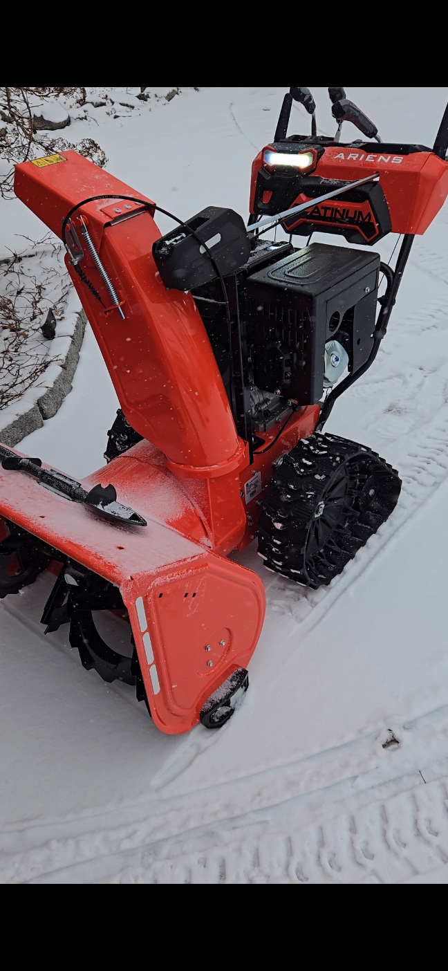
My raptor is on 35's
The ariens ate 3 to 4 foot drifts the whole way down my moms 500 foot driveway

ah, you got the track one, we decided to get the 28" "smart trac" drive, honestly I prefer my old ariens, 0 point turn, and 1st gear was slow... this one is more powerful but goes where it wants not where I want, and needs a gear between 0 and first, I have to feather the clutch to go slower, but it doesn't struggle that's what matters, it throws snow like 40', how's the turning on that one?
-
2
-
-
1 minute ago, FXWX said:
Not out of the question... just imagine if we had not been screwed 2 times after the Jan 25-26 event???
was just thinking that, we'd be probably close to 100" region wide, and honestly this storm and that norlun last week left some on the table, but nonetheless, still close to climo, I'd give this winter an A right now for that and the temps, think I had one day over 45 since early November! that's nuts
-
well that got me just a few inches away from climo avg on 2/23, let's keep this train rolling...and to think we left a couple storms on the table, and this one could have been better if we'd gotten in on that big band, after the initial 4" last night, most of the total came from about 3am to noon, and a few of those hours was visibility in feet, I'm happy, but my back is rocking... time to chill now and await the week, see how that plays out.
-
14 minutes ago, bristolri_wx said:
Just does not want to end here… jeez…

I can't believe that's still in roughly the same area, crazy...nice storm, left some on the table here but if it wasn't for that band rotting over my head it would be a forgettable nuisance storm, cleaning was tough, running out of room to put the stuff around the sidewalk area, like 5/6' piles on everyone's driveway edge, so what was the max jack? I'm sure it was posted but I don't want to go through 40 pages of posts, I see a couple 30+ amounts in RI/SEMA
-
1
-
-
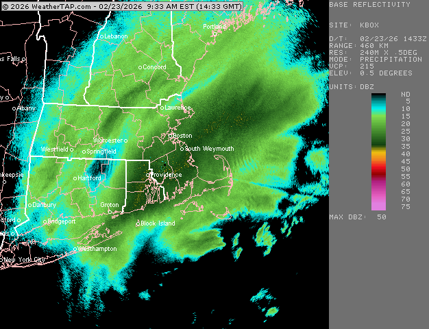
15 minutes ago, ORH_wxman said:
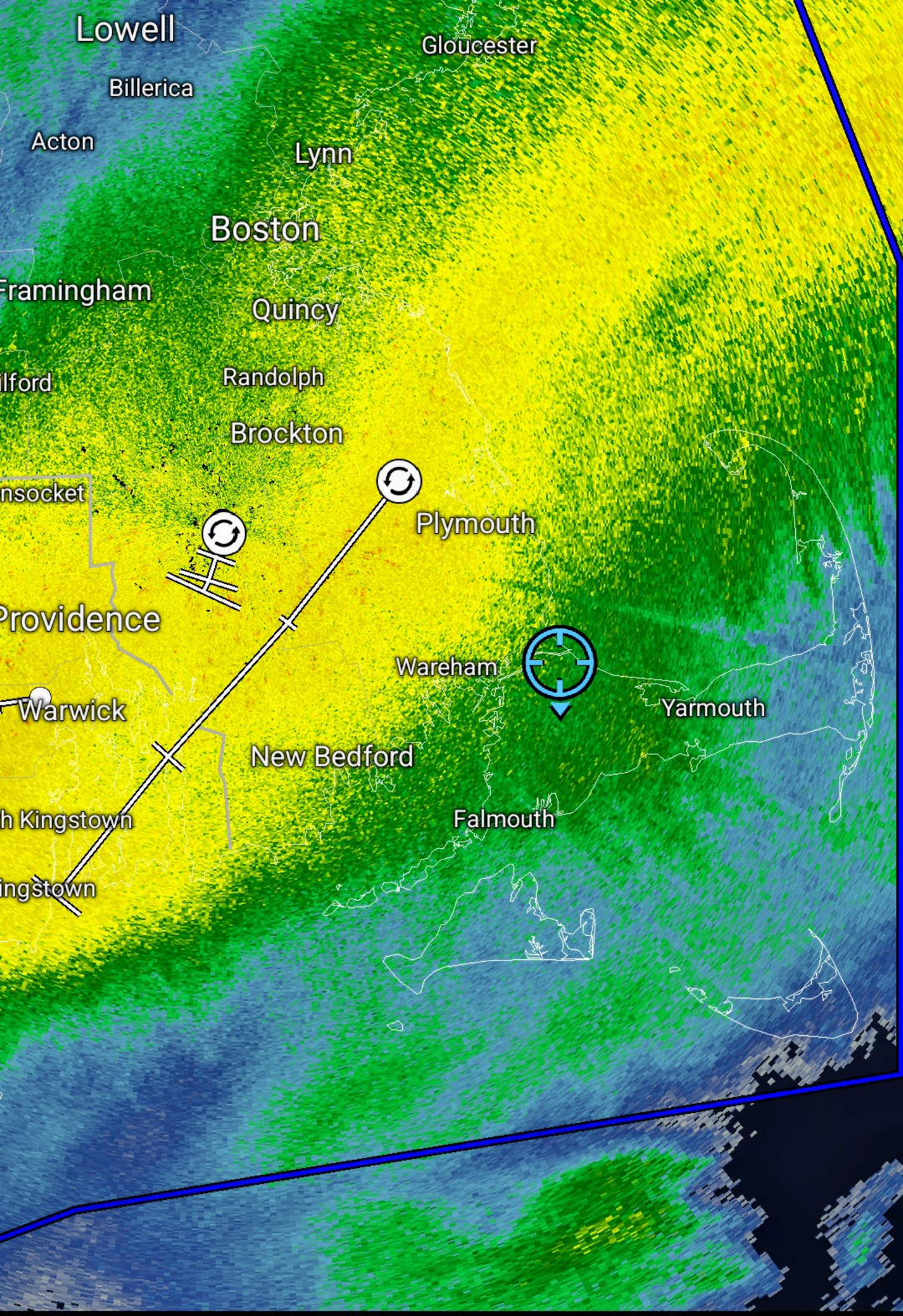
Seems to be congealing into a moderate to borderline heavy snow over E MA as the uber intense stuff is sinking a touch SE…but the subsidence zones are disappearing NW of 495
that western band while not what the fire hose has produced, has certainly made this area eventful, feel sorry for some of the CTRV folk who wound up with less than 10", my buddy in E.longmeadow said 7/8", I think that's low, because wilbraham had 12 like 3 hours ago but who knows, i averaged just over 15, still lightly snowing and about to get after it.
-
1
-
-
28 minutes ago, WxWatcher007 said:
Looks like a band is trying to regenerate over us as the other weakens over SE CT. I like seeing that. Wonder if we get some convergence with the western CT band and then it rots as it moves east.

that west band is finally fizzling out I think, still light to mod snow but nothing like before, getting ready to go out and clean it soon but man that fire hose out east delivered the goods for them.
-
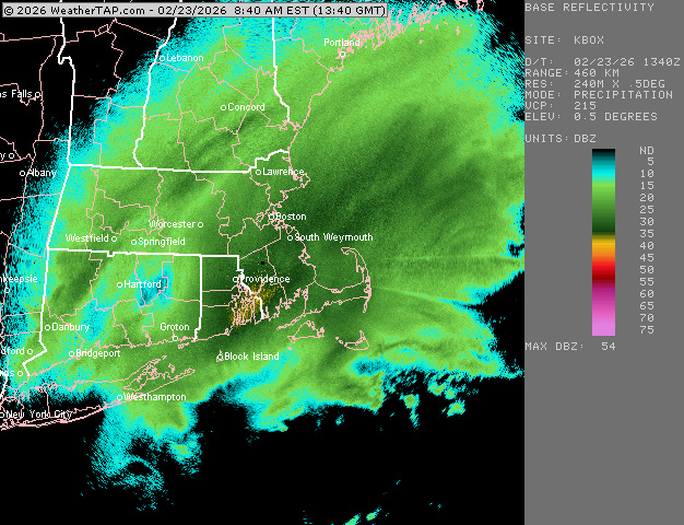
13 minutes ago, ORH_wxman said:
Crushed
Gonna be a lot of 30 burgers in RI and adjacent SE Ma
they already close, some obs of 26+ around Narragansett
-
I've got to say, I still had about 10-12" OTG before this, glacier piles on the roadside, going to be fun clearing this later, some sick drifts between the cars and the normal spots in any NE wind driven storm... seems more N-S now, my anemometer is now frozen, highest gust I had was just over 50, that was like 3 hours ago, visibility decreasing again I'm thinking about 1/2 should be done here to get cleaning up.
-
1
-
-
flake size increase but not as low vis, about 1/2sm now but still piling up, wonder if that NE banding just comes down this way or starts to rotate on east as this moves away.
-
4 minutes ago, butterfish55 said:8 minutes ago, ORH_wxman said:13” here now or so (very tough to measure but it’s def close to that. Might be more but staying relatively conservative)
Epic over SE MA.
Im on the northwest edge of the good stuff but nothing like RI and further SE
Can confirm it's epic here. Just relentless
looks like that far west band I've been under is reinforcing, not sure if it'll make it here but that would be epic and push towards 18, I'm about 15/16 very hard to measure average with snow pelting my face, it's glorious!
-
1
-
-
Just now, SouthCoastMA said:
wtf
rotation??
-
14 minutes ago, MegaMike said:
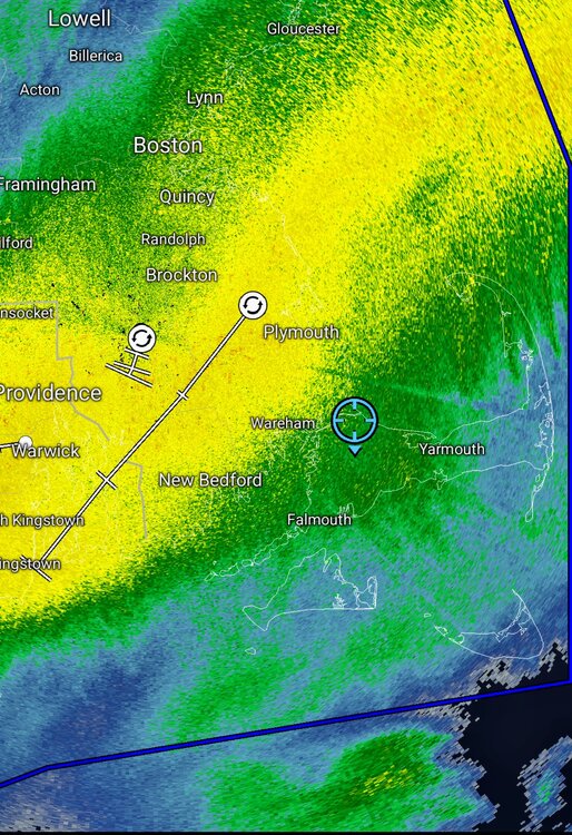
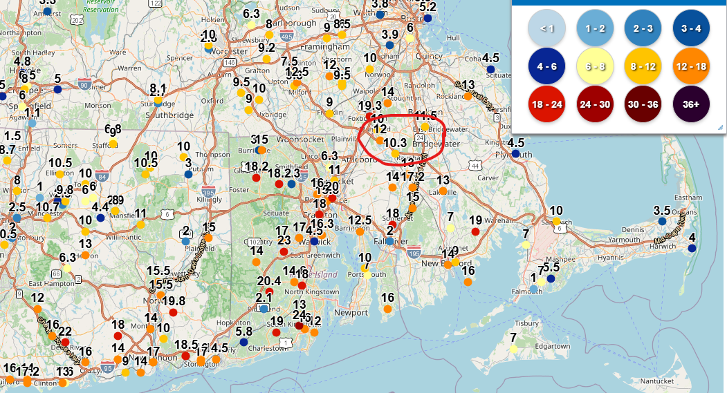
There are two observations in Foxboro of 19.3" (~9am) and 16" (8am). That checks out.
Not directed to you, but the Taunton/Norton/Mansfield observations (circled below) need to be updated. They must be approaching 16+" by now.
E. Providence w/a 20" observation now too. Good for them!
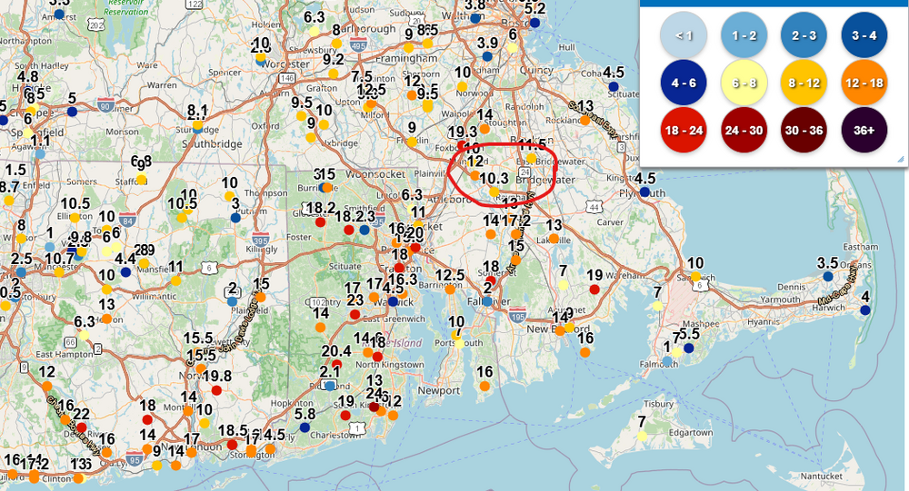
saw a few 24" reports from s.kingstown, New Bedford and PVD (looks like a city ob) but lots of 18-24 coming out of there.
-
2
-
-
that west band has really been productive, just when it eases up, the wind gusts and it snows harder, gotta be at least 15" here now, watching a 70' pine in front of the neighbors house reach it's limits is amazing, how many storms has that tree seen like this and is still around.
-
2
-

Clipper Fires In Wednesday Feb 25 Disco/ Obs
in New England
Posted
three hours delay for Torrington anyway, but I think Winsted was 2, which means I have to drive him in