

tavwtby
-
Posts
2,259 -
Joined
-
Last visited
Content Type
Profiles
Blogs
Forums
American Weather
Media Demo
Store
Gallery
Posts posted by tavwtby
-
-
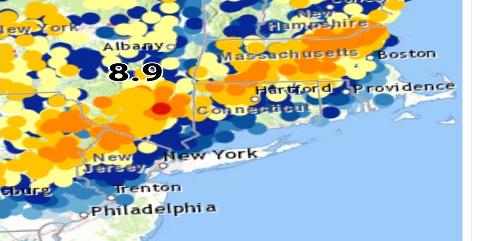
little pixelated but you can see the stripe of 10-18" right down to PA up to NH ..
-
it appears we have a zone from Ulster/Duchess cty area up to the Lowell area plus and minus about 30 miles that got 10+, that sound about right?
-
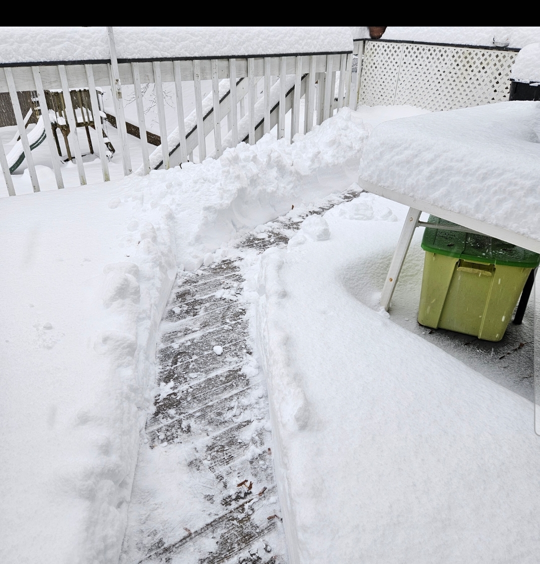
limped our way to 12.5" here with this last burst coming right as we finished doing the snow, which was as hard as it was last night surprisingly because radar doesn't look good, but under 1/2mi vis for almost an hour put down the final half inch... nice storm here for us, feel for the south peeps, looks like it's rockin up in orh cty up into SNH
-
 1
1
-
-
looks like it's rockin from about wilbraham up to Lowell, nice band consolidating there
-
looks like the last gasp incoming, if it sticks together, otherwise I'm going out to clean up, we have a newly paved driveway, so it's going to be a pleasure with the new blower as well... nothing worse than a bumpy driveway trying to snowblow or shoveling...total as of now 11.5, need a good push to top a foot
-
1
-
-
from what I just read in the AFD, it seems like a struggle between the SLPs as soon as promise shows, it dissipates fairly quickly
-
Just now, tavwtby said:
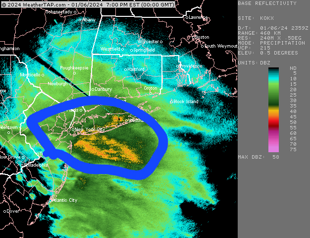
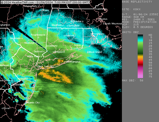
.Update...As of 9:30 AM EST...MSLP analysis now shows two
distinct areas of low pressure off the coast, one located east
of the 40/70 benchmark and another just south of Long Island
with an inverted trough extending back across the eastern
Catskills from this second surface low. At the same time, GOES
16 water vapor imagery shows the approaching upper shortwave
embedded in a longwave trough currently located over eastern PA.
As this upper shortwave tracks northeastwards through the next
couple hours, it will help to keep that second SLP minimum
tucked into the coast, and will allow the surface low to
strengthen with the arrival of better upper divergence.
so two distinct SLP, an inverted trough, and the ULL coming in the stall and strengthen the more tucked SLP, am I reading that correctly???
-
1
-
-
.Update...As of 9:30 AM EST...MSLP analysis now shows two distinct areas of low pressure off the coast, one located east of the 40/70 benchmark and another just south of Long Island with an inverted trough extending back across the eastern Catskills from this second surface low. At the same time, GOES 16 water vapor imagery shows the approaching upper shortwave embedded in a longwave trough currently located over eastern PA. As this upper shortwave tracks northeastwards through the next couple hours, it will help to keep that second SLP minimum tucked into the coast, and will allow the surface low to strengthen with the arrival of better upper divergence.-
1
-
 1
1
-
-
radar seems to be consolidating now, hopefully everyone can cash in on round 2 today
-
2
-
-
1 minute ago, The 4 Seasons said:
Toe Brogan thinks everywhere sucks except Texas
Joe the toe wound be buried under my snow he's so short
-
if we can get one of these heavy bursts to sustain for a couple hours it'll be another few inches, they seem to last a half hour then peeter out and start back up, wind is picking up too now... don't think I got above 25 the entire time, it was 25 when it started and is now.
-
1
-
-
it's ripping SN right now, on and off bursts of SN+
-
Just now, tavwtby said:
i measured 10 maybe an hour ago, but looks like another .5 has fallen since...radar filling nicely out west of us, so maybe we can get some goods until afternoon
also, Norfolk had 12 as of 6am, so I'm sure that's gone up since just for reference
-
2 minutes ago, The 4 Seasons said:
if anyone has any totals from Round 1 only in CT i can make a quick map to show we got so far.
i measured 10 maybe an hour ago, but looks like another .5 has fallen since...radar filling nicely out west of us, so maybe we can get some goods until afternoon
-
this thing is really cranking up, winds are swaying trees, knocking whatever stuck on them last night off, had a brief period of SN++, but it was short lived, back to just SN
-
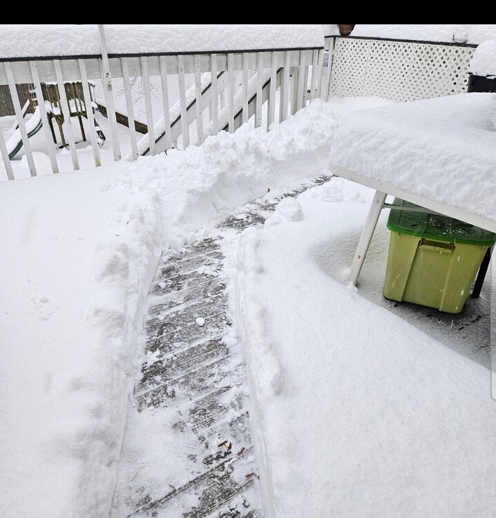
shoveled a path to the stairs, not exactly man snow, but not exactly powder either, should clean well, wrap around is filling in nicely, Hrrr really seemed to nail this one from just before go time up to now
-
1
-
-
starting to pick back up to mod SN now, had a good lull from about 330-730, I've got 10 even, Norfolk reporting 12, a couple of reports in dutchess and Ulster cty NY coming in near 14, that band was legit last night... would be nice to pick up a few more and get over a foot
-
have exceeded my expectations already as we approach 10" here, and if guidance verifies, tomorrow late morning should ramp up some deform and pick up possibly a few more, right on!
-
4
-
-
Holy crap! woke up to check and other things and we're at 8.5" since 9 and absolutely dumping snow still, wish I could have stayed up...was there any tssn reported in the band?
-
2
-
-
straight pouring snow last half hour, just about at 1" now, if these rates keep up until the morning, we'll definitely hit 8+ by then, vis well under 1/4mi now, think I'm going to fall out, so enjoy all who are staying up, just can't do it anymore
-
almost SN+ here now, my 1/4mi marker is barely visible and growth is good
-
1
-
-
16 minutes ago, Sey-Mour Snow said:

 Mesoscale Discussion 0009
   NWS Storm Prediction Center Norman OK
   0735 PM CST Sat Jan 06 2024

   Areas affected...portions of southern New England

   Concerning...Heavy snow

   Valid 070135Z - 070730Z

   SUMMARY...Moderate to heavy snow will slowly increase in coverage
   across portions of southern New England this evening. Snowfall rates
   of 1-2 in/hr are possible within the heaviest band late this evening
   into the overnight hours.

   DISCUSSION...As of 0130 UTC, regional radar and surface analysis
   showed a broad area of stratiform precipitation ongoing across parts
   of the Mid Atlantic and southern New England. Associated with an
   approaching coastal low, periodic moderate to heavy snow/rain has
   been observed within this precipitation over the last several hours.
   Slow northeastward progression of the heaviest precip has been noted
   with the primary east-west oriented band stretching from
   east-central PA to Long Island Sound. Driven by strong low-level
   warm advection ahead of the deepening coastal low, moderate to heavy
   snow should slowly increase in coverage over portions of southern
   New England late this evening and into the overnight hours. Rates
   between 1 to 2 in/hour are possible within the primary band, though
   there remains some uncertainty on how quickly the heaviest snow will
   lift northward. Light snow has already been reported across parts of
   RI, MA and CT but, regional model soundings and observed ceilings
   above 4k feet suggest some low-level dry air remains in place.
   Inland moisture advection and the approach of the surface low should
   slowly cool and moisten the low-level thermodynamic profile
   sufficiently for higher snow rates after 03z. Periods of moderate to
   heavy snow will likely continue into the overnight hours.
pound town!
-
keep an eye on this area as it pushes north, winds picked up here in the last 15 minutes, snow growth is decent atm, we coat, we reduce vis!
-
1
-
-
10 minutes ago, BuildingScienceWx said:
thx

January 6-7, 2024 Winter Storm Obs Thread
in New England
Posted
17 in Granby?? that's a crazy outlier, maybe caught more from rd 2, but overall a fairly consistent distribution in NWCT, over to ENY and up to SNH... actually that stripe went down to PA, was pretty well modeled I think.