-
Posts
2,814 -
Joined
-
Last visited
Content Type
Profiles
Blogs
Forums
American Weather
Media Demo
Store
Gallery
Posts posted by tavwtby
-
-
Just now, STILL N OF PIKE said:
Definitely my guess for them would be low to mid 20’s
Some town in S dacks on N Catskills May jack but I just threw out savoy for shiats and giggles
that would have been my choice of jack too, and to boot, next week also looks great for them, could have a 48" base for Christmas around those parts, already like 6-8 otg no?
-
 1
1
-
-
4 minutes ago, STILL N OF PIKE said:
Any jackpot guesses , anyone want to play that game
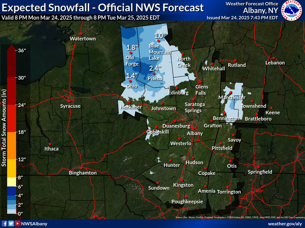
Savoy state park- 30” @2400’
yeah that area looks to get hammered, I'd probably take the under on that though, and say 24"
-
37 minutes ago, Damage In Tolland said:
Coops crushed
I usually put a tarp over it, and part of the run, so they can get out until I clean their area to scratch and peck at stuff, but I leave the snow on the coop as insulation during winter, hopefully they start producing more soon, been molting since early October, now they see white they clam up with the protein
-
 1
1
-
-
35/32 and apparently virga, I expect snow to begin falling any minute here, if not starting as liquid for a while until we wetbulb, but I can already feel it dropping over the last hour from 38, and a bit of a breeze starting, radar looks stout south of LI, we redevelopment? any pressure readings from offshore showing that?
-
5 minutes ago, weatherwiz said:
One thing that makes me nervous (especially with my forecast for northern Connecticut) in the thump zones is the majority of the stronger lift is well above the DGZ. With a marginal profile (well boundary layer), even with the more intense lift it could be difficult to get much snow. Could be dealing with crappy flakes size and horrific ratios. Have to check some bufkit soundings a bit more in-depth but I would imaging ratios could be as bad as like 6:1
was thinking the same, looks better just north with the lift and DGZ, may be looking at hours of sugar here while they pile dendrites up to the kneecap
-
1 minute ago, ORH_wxman said:
Beast is going to get a 20 burger I bet....great spot in northern Berks.
would not be shocked, and it looks like back to back with next week... they just all pulled off an 8-10er this past Sunday, good Berk winter of yore, actually lived in Pittsfield until I was like 4, have some vague memories of piles of snow
-
 1
1
-
-
kinda surprised Aly didn't at least extend the WSW to southern Berk cty, if for Nlitch cty... seems they are expecting at least 6" in these areas if not more and guidance supports, any ideas for this?
-
watch up for my hood now, guess the trend is a friend...like Ryan's map, looking good to me, can't help but look ahead at next week though, also new ariens 36" blower arrived yesterday! can't wait to give it a go!
-
berks gearing up for possibly two 16+ storms in a week huh...ALY cutting off the warning snows for this one just NW of my area, this will be one of those where Norfolk gets 6+ and I get 2/3" imby, but hold hope next week pans out, plenty of excitement in the tracking department, much better than last year
-
right on the edge of something special here, will take my couple though, already better than last year

-
Nice little area of 8-9+" around Lenox, Lee and savoy mass area
-
 2
2
-
-
6.4 was the final on the board back home, more than I expected
-
 3
3
-
-
Report from home, now my dad is out blowing and said 5.5, just checked ALY site, Norfolk at 5.5 at 820, and sandisfield the same around 730, still snowing pretty decent he said
-
 1
1
-
-
Just now, TalcottWx said:
I am in Weatogue at the new Talcott Mountain complex. Here is my station FYI
Figured as much by your handle, nice up there, love the hike to the tower, looks like you're close to 5
-
1 minute ago, TalcottWx said:
So you think 4" minimum sounds fair for Simsbury? I must be close to 5" in not too much longer.
Probably, not sure how the areas closer to the river did, where in Simsbury are you?
-
Just now, Johnno said:
I bet Winsted, Colebrook, Norfolk pull down 8”
Over 5 @home, Norfolk always does better than me so I'd bet they have at least 6
-
My dad is going out snowblower, back edge approaching but looks like it's filling in a bit, bought a new 36" blower, but won't be delivered until late week
-
1 minute ago, weatherwiz said:
The end of the week is certainly interesting. The only expectations I have right now is that it's something to track and monitor. It's a very complex pattern and evolution so we're going to see a thousand potential solutions over the next few days. The pieces are there for a big storm, regardless of precip type.
Absolutely, it's early, interesting to track
-
 1
1
-
-
2 minutes ago, mreaves said:
Are we sure it’s snow that his wife is measuring while he’s away?
Well, if it ain't snow, it's not an upgrade Ha
-
 1
1
-
 2
2
-
-
Just now, mreaves said:
Are we sure it’s snow that his wife is measuring while he’s away?
Wow
-
 1
1
-
-
1 minute ago, weatherwiz said:
This is going to be such an amazing fun week of weather. Snow event here tonight, a pretty significant blizzard in the northern Plains, severe weather Tuesday evening (though don't think it will be an outbreak), and then a potentially big storm here end of the week. Finally the boredom is over.
I hear you, hoping that end week system trends colder, not really liking where it's going right now, but some more east members showing up, regardless it looks to be interesting
-
12 minutes ago, STILL N OF PIKE said:
I am proud of you for getting multiple measurements , most wives seem like they would eye roll or look and make up a number
She knows how much I value accurate values, being in my profession and all, and knows how much I love it...plus she's the best wife ever, just sayin...
-
 2
2
-
 1
1
-
-
My wife is measuring 4.5 at home, I had her go back out and do multiple spots other than the board, confirmed...
-
 1
1
-
-
Just now, TauntonBlizzard2013 said:
Nice scene out there tonight. Looks like an inch or so, so far.
I'm so jello right now, while 80 and palm trees is nice and all, I've almost been here since Halloween...I want deep winter!
-
 1
1
-


Preliminarily ... a medium impact partial Miller B, Friday
in New England
Posted
still 35/32 snizzle now, cloud ceiling really lowered though, has that look like main precip starting any moment now