-
Posts
2,446 -
Joined
-
Last visited
Content Type
Profiles
Blogs
Forums
American Weather
Media Demo
Store
Gallery
Posts posted by tavwtby
-
-
22 minutes ago, H2Otown_WX said:
Your old place must have had more than 6". I had about 10" and I'm on the NW side of town.
nah, drove down there specifically to measure at the old place, just a tad over 6, although my BIL who lives up top of bunker hill, had close to 8.5, so maybe there was either a little elevation thing or some weird meso thing happening there... buddy in terryville also, about 7... seems like we'd have gotten more here if the growth was better, at 230 this morning it was absolutely ripping but putrid flakes, vis was below 1/4, woke back up at 5 and was less intense and similar flake size, hopefully start of a good run here, although I'll be heading to GA next Friday for a few weeks, so I'm going to miss bulk of winter.
-
 1
1
-
-
Just now, klw said:
Sometimes it is as simple as putting the wrong end of the yard stick down to the base so that instead of reading 13" it reads 23".
people should take advantage of the skywarn classes they offer, I took it many years ago to be a spotter and go through the proper way to measure, all weather parameters not just depth, how often to clean, LE, etc, pretty interesting little class.
-
14 minutes ago, The 4 Seasons said:
just saw a report from Blue Hills of 15.2, thats gotta be the max so far?
was just going to ask who came in the highest, don't like how they do the text bulletins now, unless they moved to a different place, used to be easy to read, highest to lowest per cty, had to skim through, seems like norfolk cty and windam cty got the goods for the most part, ended with 3.5" on the dot on the table, but old place in Waterbury had close to 6, more further SE into that fronto band. saw a report from I think killingly of 13.2? I don't remember if that's correct but that area had some 12+ totals
-
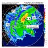
looks like some nice totals under that band, congrats, I was just too far NW for anything substantial, but still eeked out what looks like 3.5 here, haven't gone out yet and still light snow, but looks like it might be curtains per radar, congrats folks, it's white!
-
 2
2
-
-
I thought I was surprised, wow some of those totals so far under that band good times approaching Dr
-
pretty decent rates out there, snow growth could be a little better but close to an inch eyeball, and I'd say at least an inch an hour rates, you can see where the band is setting up
-
 1
1
-
-
18 minutes ago, WhiteLawns said:
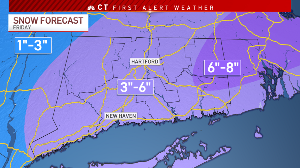
Do you think we’ll get low end of your map in the torrington area?
perhaps my initial 1-3 was a good call for our area, got a bit excited seeing yesterday trends, but that convection offshore has been there nagging for days now, have to say don't expect more than a a couple inches, more would be great, but wishcasting leads to disappoint
-
 1
1
-
-
18 minutes ago, WinterWolf said:
2/5/16 was the one that hit right after the super bowl that morning.
that one sucked out here, great east though, I had like 6 hours of heavy sand... remember that very well
-
3 minutes ago, HIPPYVALLEY said:
WTF? All the school districts around here have already canceled for tomorrow.
We were already marginally on the fringe of this system. If this nowcasts East, it’s going to be laughable that they canceled for an inch or two.
how many times that's happened since I left school, I remember going to school and seeing plows, now the hint of flakes has them cancel.. although a few years ago, there was unexpected high bust and busses with kids got stuck all over Waterbury on some greasy snow, that was embarrassing for them, catch 22 in that respect
-
 1
1
-
-
30 minutes ago, moneypitmike said:
Send some of those to 495/pike
Yeah--it's a fascinating history of the lost towns of the Quabbin: Dana, Greenwich, Enfield and Prescott. I've read a few books on the history of it--really should be a movie. Not a Deliverance movie--though that had to do with drowning a town, too.
didn't they do that for candlewood lake too? I remember stories when I was a kid and we had a boat slip ther, that there was villages between New Milford and danbury that were under, I thought maybe urban legend... anyway, my buddy in Baker WV says it's poundtown there right now, easy 1/4 sm vis or less, expecting 4-8 with a WSW there, KY was gridlocked today, just like VA last week, of course blamed on nonsense, but weather don't stop
-
-
https://www.wtvq.com/accidents-pile-up-i-75-northbound-closed-in-some-areas/
KY, WV getting slammed, same situation as VA last week... good thing I'm going down to GA next Friday and not this Fri...
-
Just now, Sey-Mour Snow said:
I don't think it matters how robust it is for me and you, it's all about when the transfer occurs, we need that to trend earlier for us.. bc if it doesn't we get the 7-10 split. the good runs pulled the stuff from the west right over us plus the developing coastal moisture..
yeah, what I worried about, we'll be sucking exhaust with flurries and sand, while initial thump west and best forcing east, doesn't appear that will happen with this one though, we'll see, we all just want some white ffs! it's winter.
-
7 minutes ago, Lava Rock said:
Email from Spectrum thinks we're getting severe weather from 2-4". Oh no! Run and hide. Prepare while you can. Seek shelter. More fear porn.
"Recent forecasts indicate severe weather may affect your area. As a result, we're preparing for Spectrum service outages. If you lose power, please contact your local power provider."
in the era of fear and panic, a few inches of snow warrants severe warnings... enjoy the snow everyone, whatever falls, should be fun now casting
-
so, what's causing the wobble on off runs with the nam? is it that convection offshore?
-
GFS west, all onboard westward and stronger sharper
-
9 minutes ago, CT Rain said:
Pretty sizable jump NW on the EPS.
let's keep em coming, I'd like more than a couple inches
-
54 minutes ago, weathafella said:
I can’t remember the details but you were bullish! It was a frustrating start not unlike this year and I was starting to lose faith…
that was a great run, better for eastern areas than imby, but still good nonetheless... my favorite stretch, again parallels to this season ytd, was 10-11, where boxing day started an epic Jan that had my roof with just shy of 40" at one point, roofs collapsing everywhere too, I had to dig a trench for the oil delivery and by the time I got to the street it was over 6', because the blowing and plowing throwing up on the front lawn, but I remembered seeing almost like rock formation, where you can see each storm level like digging for fossils, crazy stuff
-
which station does the whole SNE snow map, ALY and OKX only do their forecast areas and I'm having issues loading it, if someone can throw that up would appreciate it
edit I got it to load
-
48 minutes ago, IowaStorm05 said:
Anybody like whiskey? That’s what I got now. Woodford. Great deal on a 200ml down the road. Only bought enough for a few. I had a decent day at work but it was wet and I was outside, and some folks don’t behave the way that I think that they’re supposed to. Sometimes people get really creepy, outdated, and inaccurate. I’m not talkin mean customers. I’m talkin bout weirdos.
And my layers of mental disability, despite my genius, limit me to 25-30 hour workweeks. You say you live to work. That would kill me.
had Woodward on Xmas eve for the first time, excellent and smooth..BIL is a liquor vendor, got a bottle for my 1-3 Fri!
-
 2
2
-
-
you know people are itching when we're nearly a week and 100 pages deep on a 1-3/3-6 event for SNE... we're all praying for last minute changes I'm sure but I think we can lock this in now... although kinda had a feeling this wouldn't be the one we thought from go, but still have some time to correct west and amp some more I suppose, onward to mid month!
-
 1
1
-
-
NAM seems to be an outlier here, seems like every other model is showing decent surface low placement and H7 looks good to me, even on the 6z nam through 48hr, no?
-
after 0z will be more confident in anything, always wanted to wait until 48 out before lock, too much waver, as it's sampled more, if we still have this look tomorrow morning, I think we're good, better east, but still all SNE gets plowable imo
-
looks a little more progressive, or am I reading that wrong


Jan 7 Two-Headed Coastal Obs
in New England
Posted
yeah I love winter, and all this, but I'm the only one, and so much more opportunity there, severe season should be a blast though, good luck!