

tavwtby
-
Posts
2,814 -
Joined
-
Last visited
About tavwtby

- Birthday 01/03/1973
Recent Profile Visitors
7,581 profile views


-
man I do miss the smell of rain after some heating, dews got up to near 60, everything falling back now, severe warning near MDT, see if they can stay together for this area.
-
think I've maxed here at 64, was looking at temps in upstate NY, Oswego was near freezing while BGM was at 72F not long ago, crazy swing
-
was decent here high of 54, could have been more but clouds ruined it, and it dropped, then sun came out for a bit again and we spiked back over 50, but clouds again, down to 46 now good melting happening, but still good amount of cover and piles
-
so, I've got to drive to Greenville SC on the 17th/18th and taking I81-77-85, any chance I run into any weather (as it looks now) along my journey? also be returning the 20/21st... thanks in advance for those who dive deep into the LR.
-
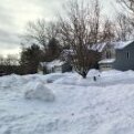
two nice events, 15+ here and the cold and pack retention, I mean I still have about 10-15" depending on where in open areas, still piles of 4-5' in spots, probably almost gone this time next week but was a solid winter, didn't make climo yet snow wise yet, about a foot away still.
-
it's gorgeous out honestly, was a mess earlier but everything falling with full sun and soaring temps.
-
never got above 30 here and it has been liquid for hours now, albeit light but still.
-
I'm down, gonna look nice in the morning with everything glazed.
-
maybe the models weren't that far off with the ZR, at least .20" of accretion here, and looks like plenty to go, stuck at 29°...man my deck is a skating rink
-
absolutely pounded paws for about a half hour, not 50/50 SNIP mix, but made an inch, so we stat pad...
-
well if this keeps up I'll make an inch or two, some paws coming down now.
-
27/24 and heavier echoes coming in almost a mixed bag back and forth to snow at times here less than a half inch so far meh
-
I homeschool as well but have one that's a freshman at a tech school so when he gets off I give the other one the day off too, but radar looks like a mess, and he hasn't had a full week since before the break, although he did get suspended for some nonsense, however they used to complete all their school work in a couple hours as opposed to all day bouncing around to classes and breaks/recess etc...my opinion there should have been school today, even here I'm close to 32 already and half inch maybe otg
-
down to 7.5° here pretty impressive, actually looking forward to some warmer weather, I have vehicle work to do and the garage is like a freezer, plus the coop took a hit this year, need to get on that.
-
like Will said, mid month to about the 25th looks like there's plenty of fresh cold, and something could pop, I do think the torch will be a little more muted than 70s, maybe a day that hits 60+ but I'll take a few days in the 50s, I'm starting to get over it if it's not going to be cold and active, have so much spring shit to do, but I still have feet of snow in some spots, so a couple torch days with high DPs would be nice to get that down. one more biggie would cap off a good winter imo.

