

Eduardo
-
Posts
1,030 -
Joined
-
Last visited
Content Type
Profiles
Blogs
Forums
American Weather
Media Demo
Store
Gallery
Posts posted by Eduardo
-
-
I’ll be thrilled to at least have it cold for Xmas, even if we can’t luck our way into some appreciable snow. Nothing worse than a true, balmy Torchmas.
-
 5
5
-
 2
2
-
-
2 hours ago, Allsnow said:
That cold shot around the solstice is trending colder on the ensembles. Would be a change from years past if we are actually cold around that timeframe


2022 had and in-and-out cold shot centered around Xmas Eve IIRC. Regardless, if you’re looking for snow to the coast, this pattern ain’t it. I’m thinking there might be a short window or two later on in the winter though….
-
Got married on Saturday and am in Lake Placid for the week. If you like snow, consider visiting here!

-
8
-
-
3 hours ago, Rjay said:
Merry Christmas eve
Let’s face it, we knew this was coming last Xmas Eve
 .
.
-
1
-
-
Human psychology is a helluva thing lol. Singular model runs sometimes over-detect trends and then sometimes over-correct. The cold will almost definitely relax for the second half of the month, but it’s a good sign that we are seeing some this early.
Also FWIW, I like the PAC look much more than I have for the past two winters. I think the 13-14 comparison is probably overstated, but unlike the past few years, I think we might get a few periods this winter where the EPO cooperates.
-
1
-
-
18 hours ago, Dark Star said:
That's okay, the Macy's parade has become a joke. Even CBS is not going to air it...
Mods can remove for off-topic, but I’m curious what you think has changed about it. To me, it’s the same, cheesy constellation of advertisements that, for some reason, I’ve always enjoyed watching since I was a little kid.
Also, wasn’t it always on NBC?
-
32 minutes ago, cleetussnow said:
If we break 6 inches in December, generally speaking we are at least average, usually above for the season. I was just looking at this and IIRC in the last 30 yrs there is only 1 season where that did didn’t work out, but it was still close.
I think that Chris (@bluewave) had some stats on this. There’s also a strong positive correlation between December’s AO and how that teleconnection plays out over the remainder of the winter, though I don’t know what impact, if any, ENSO has on that.
-
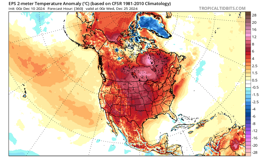
2 hours ago, donsutherland1 said:
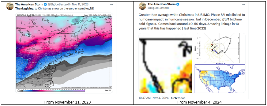
Dreaming of a White Christmas or "big time cold" in December? Joe Bastardi is suggesting above normal odds.
The problem with that is that he makes similar calls on a regular basis during the first half of November. For example:
There is no forecasting skill from this far out. Any successes are matters of random chance, not skill. Forecasting for specific dates in the distant future is more astrology than meteorology.
The maps are intended to shock and draw attention. A similar posting pattern occurs throughout the winter where severe to extreme maps are posted on a regular basis. For example from last winter (January 18, 2024):
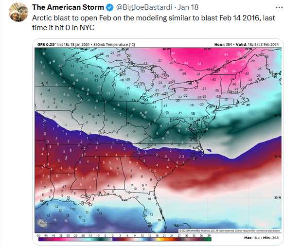
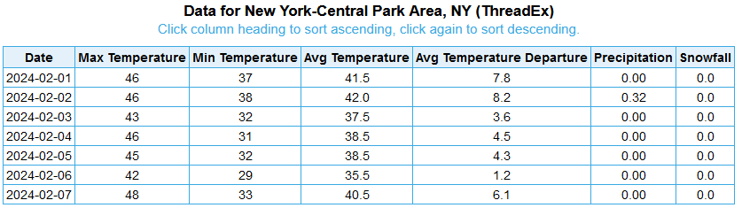
The outcome for the first week of February 2024:
And when the severe to extreme ideas don't verify, fresh calls for severe to extreme cold/snow are posted for future periods. Already, he's embracing December cold and snow after previously suggesting a cold second half of November with an above average idea of a white Thanksgiving (September 30th post).
Most here are aware of his track record and forecasting tendencies. New members might not be aware. Thus, this post to alert them to be cautious about Social Media claims with wild maps.
I used to really enjoy his enthusiasm 25 years ago when he was at AccuWx. But, even though I think he’s probably a decent person, he’s really just become like a cantankerous old uncle that refuses to adjust his views to new information.
Given how seldom his hyped-up forecasts verify though, I wonder how he stays in business. He holds himself out as a consultant, but is he keeping his gig going with weenie subscriptions?
-
4
-
-
6 hours ago, WinterWolf said:
Thing is, it’s not even late fall yet. Another 3 weeks or so it will be getting there though. But even 8 years ago…in the Super Nino of 2016, you guys killed it with the monster blizzard there in the city. That missed most of SNE(Southern CT did well. Here in central CT I got about 10-12 from it. But Once north of here it dropped off dramatically). So shit happens.
Oh no doubt about it! To be clear, I’m not in the it-will-never-snow-again camp. It will. But as an avowed retention snob who—perhaps sadistically—lives for any kind of cold during the fall and winter, things have been tough for me down here since ‘14–15.
-
1 minute ago, CoastalWx said:
I'm worried.
Visiting you all from the NYC sub. I’m probably even more worried. Would love for it to at least feel like late fall here. After a decade of freakishly warm winters, I must admit, it’s actually starting to get to me a bit.
-
19 hours ago, bluewave said:
It’s funny that the snowfall climo has actually been better December 1st through 17th since 2011 in NYC than later in the month. NYC hasn’t had a decent late December snowstorm since the Boxing Day blizzard in 2010. My guess is this is related to the warm up we have been getting every year during the 2nd half of the month since 2011. High temperatures of 55+ have been very reliable from the December 17th through 25th.
Time Series Summary for NY CITY CENTRAL PARK, NY
Click column heading to sort ascending, click again to sort descending snowfall 12-01 to 12-172023-12-17 T 0 2022-12-17 T 0 2021-12-17 T 0 2020-12-17 10.5 0 2019-12-17 1.8 0 2018-12-17 T 0 2017-12-17 7.0 0 2016-12-17 3.2 0 2015-12-17 0.0 0 2014-12-17 1.0 0 2013-12-17 8.6 0 2012-12-17 0.0 0 2011-12-17 0.0 0
Time Series Summary for NY CITY CENTRAL PARK, NY
Click column heading to sort ascending, click again to sort descending snowfall 12-18 to 12-312023-12-31 0.0 0 2022-12-31 T 0 2021-12-31 0.2 0 2020-12-31 T 0 2019-12-31 0.7 0 2018-12-31 T 0 2017-12-31 0.7 0 2016-12-31 T 0 2015-12-31 T 0 2014-12-31 T 0 2013-12-31 T 0 2012-12-31 0.4 0 2011-12-31 0.0 0
Time Series Summary for NY CITY CENTRAL PARK, NY
Click column heading to sort ascending, click again to sort descending max temp December 17th through 25th2023-12-25 62 0 2022-12-25 58 0 2021-12-25 60 0 2020-12-25 61 0 2019-12-25 57 0 2018-12-25 61 0 2017-12-25 55 0 2016-12-25 58 0 2015-12-25 72 0 2014-12-25 62 0 2013-12-25 71 0 2012-12-25 56 0 2011-12-25 62 0 The Torchmas spirit we have all come to expect. Definitely a noticeable trend.
-
13 hours ago, MJO812 said:
I mean, even if that were to happen (and that’s a big if), wouldn’t it be too little too late?
-
6 hours ago, 40/70 Benchmark said:
Its just another piece of guidance, all of which have their stengths and limitations. It makes sense to me that it would fall flat during a super el Nino...for instance, the polar domain was actually pretty decent in 1997-1998, but due to the situation at hand it didn't matter. I think its fine to use the SAI to either increase or decrease confidence in a forecast and/or in the absence of no other prevalent indicators.
Me too, but isn’t it just a (perhaps weak) proxy for assessing other indices then? Even if it’s used solely for confirmatory purposes, why not just keep to the major indices, teleconnections, etc.?
-
10 minutes ago, 40/70 Benchmark said:
I'm not debating your point, but I will say that I do think it offers some utility. I certainly wouldn't base an entire outlook off of it....I use it to either bolster confidence or to introduce an alternate perspective.
Can you explain this (when you have time)? I’ve always been a skeptic myself—more so in recent years, obviously.
-
16 hours ago, GaWx said:
*Fwiw* JB keeps hinting at a cold Nov/Thanksgiving/Dec for the E US. I’m not putting much weight on that for obvious reasons. Also, on Oct 8th he ditched his +2 for Megapolis for Nov-Mar for a NN (+1). And that’s obviously subject to further cooling in later updates. Keep this in mind: Since at the very least 2014-5 (because they’re all circulating on the internet back to then), JB has yet to have a mild FINAL Megapolis winter forecast. With the number of mild winters (5 of the 10) there have been, that’s not a good record. The ones 3+ AN at NYC since 2014-5 for those who don’t know were 2015-6, 2016-7, 2019-20, 2022-3, and 2023-4.
A. The 5 mild NYC winters (vs respective 30 yr mean):
-JB had -1 for Nov-Mar 2023-4 vs actual of +4 (DJF N/A). So, he missed by -5
-He had +0.5 for DJF 2022-3 vs actual of +5. So, he missed by -4.5
-He had -2 for his final DJF 2019-20 (vs earlier fcast of +0.5) vs actual of +3.5. So, his final missed by -5.5. So, his earlier fcast was not as bad (miss by -3).
-He had -2 for his final DJF 2016-7 (vs earlier fcast of 0) vs actual of +4. So, his final missed by -6. So, his earlier fcast wasn’t as bad (miss by -4).
-He had -2 for both his initial and final fcasts for DJF 2015-6 vs actual of +5.5. So, he missed by -7.5.
So, for the 5 mild NYC winters:
-The avg of the absolute value of his final fcast misses was 5.5 and his avg bias was -5.5. The range was -4.5 to -7.5.
-He revised 2 of the 5 significantly colder, which resulted in larger - misses.
—————————
B. The 5 non-mild NYC winters:
-2021-2 had -0.5 for final Nov-Mar (vs 0 for initial). The actual was +1 (DJF N/A). So, his final missed by -1.5 and his earlier fcast was slightly better (missed by -1.0).
-2020-1 had +0.5 for his final DJF (vs +3 for his earlier). The actual was +0.5. So, his final was perfect! Also, his earlier fcast wasn’t so good (missed by +2.5) meaning his change was great!
-2018-9 had -2 for his final/initial DJF vs actual of +0.5. So, he missed by -2.5.
-2017-8 had 0 for his final DJF (vs +0.5 for initial). The actual was +0.5. So, his final missed by only -0.5. His earlier fcast was perfect.
-2014-5 had -2.5 for his final DJF (vs -3 for initial). The actual was -4. So, his final missed by +1.5. This is the only one of the 10 that was actually cold, for which he missed too warm, and for which he revised warmer. This also was his coldest fcast. His earlier fcast was slightly better (miss by +1).
So, for the 5 non-mild NYC winters:
-The avg of the absolute value of his final fcast misses was 1. The avg bias was -0.5. The range: -2.5 to +1.5.
-He revised 4 of the 5 (3 cooler and 1 warmer).
———————————C. Summary of all of last 10 winters at NYC:
-He did well when winter wasn’t mild as his bias for those was only -0.5 and avg absolute value of misses was only 1. His coldest fcast was for the coldest winter.
-He did poorly when winter was mild with a bias/avg miss of -5.5 (avg absolute value of misses was 5.5). He didn’t predict a single mild winter. He was able to predict well the one cold winter. He’d be a much better forecaster if he’d improve on forecasting mild winters but that’s hard to do when he doesn’t forecast them. That’s why I route for him to predict mild and stick with it.
-None of his 10 final forecasts were mild (warmest +0.5/NN) (5 were NN and 5 were BN) as they were from warmest to coldest:
+0.5, +0.5, 0, -0.5, -1, -2, -2, -2, -2, -2.5
That means that IF his final fcast of +1 for 24-5 doesn’t change, it would still be the warmest since at least 2014-5 despite the cooler revision from +2 to +1.
-6 of the 10 winters were +1 or warmer. The avg of the winters was +2 vs his avg of final fcasts of -1. So, he was too cold by 3 on avg for the 10 winters! So, a bias correction of +3 would probably be appropriate.
-He predicted on avg -1.3 for the 5 warmest winters and -0.9 for the 5 coldest winters
-He had revisions for 6 of the 10. Of these 6, 5 resulted in a worse forecast and only one a better forecast. Of these 6, 5 were revised cooler just like the one he just did for 2024-5. Only 2014-5 was revised slightly warmer.
@bluewaveYou might be the only person alive with the patience and dedication to work up a verification like this!
Like many of you, I also grew up watching JB’s Accuweather vids and loved his enthusiasm. I still think he’s probably an all-around good guy, but I can’t for the life of me understand how a person with such scientific training can allow their brain to become pickled in the nonsense he puts out in almost crusade-like fashion. Fascinating, in a way.
-
1
-
 1
1
-
-
2 minutes ago, MUWX said:
Levi pointing out that recon confirms an ERC is making an attempt at getting underway
“[M]aking an attempt” is accurate though, IIRC, we have seen some storms during the past few seasons that featured double- and even triple-maxima without completing a full ERC and weakening accordingly. Maybe someone else can chime in and double-check my memory though.
Either way, ERC’s remain incredibly hard to predict.
-
1
-
-
4 hours ago, bluewave said:
We have two issues at work along the 1-95 corridor in the NYC Metro forecast zones. First, it was like someone flipped switch to warmer with the +13.3 December 2015. But we were still working with more of a favorable +PDO-like pattern into 17-18. The Benchmark storm track was still going strong since the 09-10 or even 02-03 winter with regular record snowfalls. But especially from 15-16 to 17-18 record warmth very close to our big snowfalls. We had blizzards when it was in the record 60s days before or after the snows. I got used to rapid snowmelts following the storms. So the snow cover days were declining relative to past colder and snowier seasons. We went from record warmth with 70s near Christmas in 2015 to one of our greatest snowstorms in January near 30” in NYC. Then a brief Arctic shot in February for the first below 0° since 1994. But a quick recovery back to the 60s following this. 16-17 was also one of our warmest winters but we managed some great snowstorms even if the 60s were close by. Then the 17-18 winter started with a great Arctic shot after Christmas and record 950 mb Benchmark blizzard in early January. But a quick reversal in mid-January and then record 80° warmth in February before record 30” inch snows in March. Much of this volatility was a combination of record MJO 4-7 activity interacting with the lingering +PDO. A great November snowstorm in 2018 before the Pacific began to shift.
This takes us to the second factor which was how hostile the Pacific has become with a -PDO signature in this warming climate. 18-19 witnessed a rare El Niño failure due to the record WPAC warm pool which has been driving the warm MJO phases. So we went most of the winter with only a snow squall to show for the pattern while the Chicago area was seeing record cold in the -20s. Then we got into the turn of the new decade in 19-20 with a raging polar vortex and Pacific Jet with more warmth and well below normal snows. 20-21 was a nice reprieve but it was still warmer than average even with a great +PNA -AO. This would have been a much colder pattern in the past like 10-11 was with similar levels of blocking. But the block became too south based favoring places like BGM for the record 40” smowstorm before Christmas. But then the raging Pacific Jet returned on Christmas with the 40” snow pack melting rapidly and causing flash flooding and landslides at the ski resorts. 21-21 started with record warmth in December before seeing our last good winter month in January.
The most recent stretch since February 2022 to this past winter was our warmest and least snowiest so close together with numerous locations setting records for stretches with under 4” and 2” snowstorms. We made it to a record 9 warmer winters in a row with some degree of Southeast Ridging.
Now we are faced with another extreme global temperature jump even exceeding the 15-16 one. So I am waiting to see what this new even warmer baseline jump looks like in the coming years. So you see we were able to manage the warmth for great snowstorms before the Pacific shifted. But this hostile storm track plus the warmth has been a very challenging winter mix. When we did shift the MJO to 8 in January 2022 places like ACY were able to manage a record 30” month. But that was a fleeting pattern before the MJO went right back to 4-7. So even a short term favorable Pacific period can still produce to some extent. The question now becomes over the next few winters can we still manage a few of these favorable periods even with this new higher temperature baseline. I will remain open and take a wait and see approach. All these new marine heatwaves are really distorting how our past climate used to operate.
I feel like this post should end up in some historical archive some day. I too believe that the ‘15-16 uber-Niño shifted the rules of the game and we’ve all been given a hard reminder that the state of the worlds largest ocean dictates much of the world’s sensible weather.
I do think that, despite the warmer baseline, us I-95 snow weenies will still have periods where we cash in big. But it’s going to be feast or famine (i.e., more extremes) and, as the decades pass, probably more famine than feast.
-
2
-
-
32 minutes ago, jm1220 said:
I don’t enjoy either what he posts in terms of the outcome or Snowman but where have they been wrong? I’d rather take the bad accurate news than get JB’d for the season to ultimately fail. And it was in the NYC forum exclusively I think but Bluewave was plenty bullish before 2018 when this crap pattern really got underway and pointed out how great things have been for NYC/LI up to then. It’s unpleasant honesty but it is what it is.
I would also add that Chris was plenty bullish here and over on Eastern (IIRC) during the heavenly era we experienced beginning in the mid 2000s—and especially 13-14 and 14-15. He’s probably one of the most objective contributors in this community of ours.
-
1
-
1
-
-
18 hours ago, MJO812 said:

Oh dear. As pretty as it looks my man, let’s not start torturing ourselves already…..
-
1
-
-
2 hours ago, TriPol said:
How long until we need to break out the coats?
January…..2036

-
1
-
-
10 hours ago, Will - Rutgers said:
that would be enough rain to break area darns
Still gotta get the boys to Bassfest!
-
1
-
 1
1
-
-
1 hour ago, Allsnow said:
Looks like it will miss just to my south. Brutal
great light show
Yeah seeing it from up high in Manhattan. Hope you all to my south are enjoying!
-
1
-
-
-
2 minutes ago, bluewave said:
Looks pretty rough on the Henry Hudson.
Oh wow. Nothing like that here (yet, at least).


Extended summer stormlover74 future snow hole banter thread 23
in New York City Metro
Posted
Thanks so much everyone! We’ve been up there a few times and it’s become our wintertime happy place. As weenied out as I was (it snowed almost the entire time we were there), I don’t think city folk like us could ever make the move—though I definitely understand the appeal.
Beautiful, picturesque town with some incredibly lovely people and excellent though. Can’t recommend it highly enough!