

FPizz
-
Posts
2,335 -
Joined
-
Last visited
Content Type
Profiles
Blogs
Forums
American Weather
Media Demo
Store
Gallery
Posts posted by FPizz
-
-
10 minutes ago, Hurricane Agnes said:
This looks like it is moving in your general vicinity!
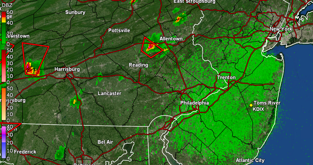
My brother is under that cell in Kutztown and getting hail slightly larger than pea sized. He said the lightning is intense and thunder super loud.
-
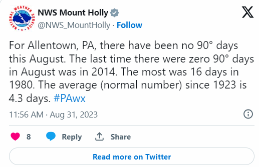
52 minutes ago, bluewave said:
They have a nice tweet out today on the topic.
I guess time will tell how good they are?
-
-
Just .09" here
-
9 hours ago, SACRUS said:
2019, 2017 most recent
EWR:
2019 : -0.2
2017 / -2.4
Thru 8/28
EWR: +0.2
Is Newark the only station that is + from when you do your temp readings?
-
31 minutes ago, Volcanic Winter said:
Lived in North Brunswick at the time. Irene was kind of a shitshow. Rode the storm out at my sister’s house in northern Toms River with my parents, and I remember it taking hours to get home back to NB with my girlfriend (now wife).
Yeah, I was in Piscataway at the time. Lots of flooding all over and my basement took on water
-
 1
1
-
-
-
.42 this morning
-
2
-
-
55, pleasant morning.
-
2
-
-
5 minutes ago, 40/70 Benchmark said:
I am willing to bet that you can find one or two duds in EVERY ENSO state.
Often? Jan 2016 is the only super el nino HECS I know of that missed south...and it was a brush, not a whiff.
Yup, 26" where I am in CNJ
-
Cloudy 86
-
-
47 minutes ago, uofmiami said:
Because the warm overnight lows with high DPs skewed temps, that's how.
Yup, being the 4th warmest all time for overnight lows does that. .
-
 1
1
-
-
53 minutes ago, winterwx21 said:
Yep Allsnow got a lot of rain but we just missed it. Only .13 here. Like you said it's no big deal since we've had plenty of rain.
Looking forward to the beautiful weekend with very low humidity. One rare hot day on monday, and then more beautiful low humidity weather with temps only in the low 80s tuesday through thursday. What an August we're having.
You get some rain yesterday afternoon too? My sister did in PWay. Only .08" here last night.
-
2
-
-
1 hour ago, bluewave said:
Regardless of the ENSO state, the Northeast has had 8 warmer than normal winters in a row. We have had various flavors of La Niña with a super El Niño and uncoupled El Niño states. Snowfall was outstanding through 17-18. Then we entered a less snowy period since 18-19. What would work for us with and El Niño would be a raging STJ carving out a SE Trough with blocking. That would mute the influence of the SE Ridge. But we saw in December 2015 how we got the unfavorable MJO 4-6 which pumped the SE Ridge to record levels. We got a great pattern during that January and February when the SE Ridge was muted and we had a strong block across the pole.
The 5 winters since 17-18 I have averaged 22". That is like 7" below normal for here. I've been measuring in the area since 1987.
-
.85" last night. The downpour woke me up.
-
2
-
-
.51" last night. Not bad.
-
2
-
-
.63 from that tornado warned cell. Epic lightning in it.
-
3
-
-
4 hours ago, BucksCO_PA said:
Since 2010 Sept has been much more summer like as opposed to the traditional start of fall. Recently Sept has been great month to hit the S. Jersey beaches, ocean water in the 70's & plenty of days in the 80's even late in the month.
My personal clock doesn't hit fall until OCT 1st.
Fall typically lines up better with the traditional change of seasons not met fall
-
1
-
-
1.00 exactly for me
-
2
-
-
1 minute ago, Allsnow said:
Tornado def on the ground
I'm in Florida, but my weather station is up to .75. Still going up too, not bad
-
3
-
-
26 minutes ago, Allsnow said:

Get us to .75 and I'll be happy
-
3
-
-
Raining, had a 40 mph gust
-
1
-
-
10 hours ago, GaWx said:
I'm guessing that Nino 3.4 will drop to +1.1 in tomorrow's report from +1.2 last week.
It did from what I just read
-
1
-


E PA/NJ/DE Fall 2023 OBS/Discussion Thread
in Philadelphia Region
Posted
That is funny. My niece was probably working the folk festival at the time.") Yeah, where I am in NJ it is 95/75
Yeah, where I am in NJ it is 95/75