

FPizz
-
Posts
2,386 -
Joined
-
Last visited
Content Type
Profiles
Blogs
Forums
American Weather
Media Demo
Store
Gallery
Posts posted by FPizz
-
-
@Allsnow getting it
-
 2
2
-
-
18 minutes ago, winterwx21 said:
Looks as if that cell in Somerset might miss us just to the south and east, but it's gonna be close.
Looks like it is over Piscataway, maybe just skimming the River Road part though. Not sure where you are. I lived in Pway for the 1st 37 years of my life.
-
1
-
-
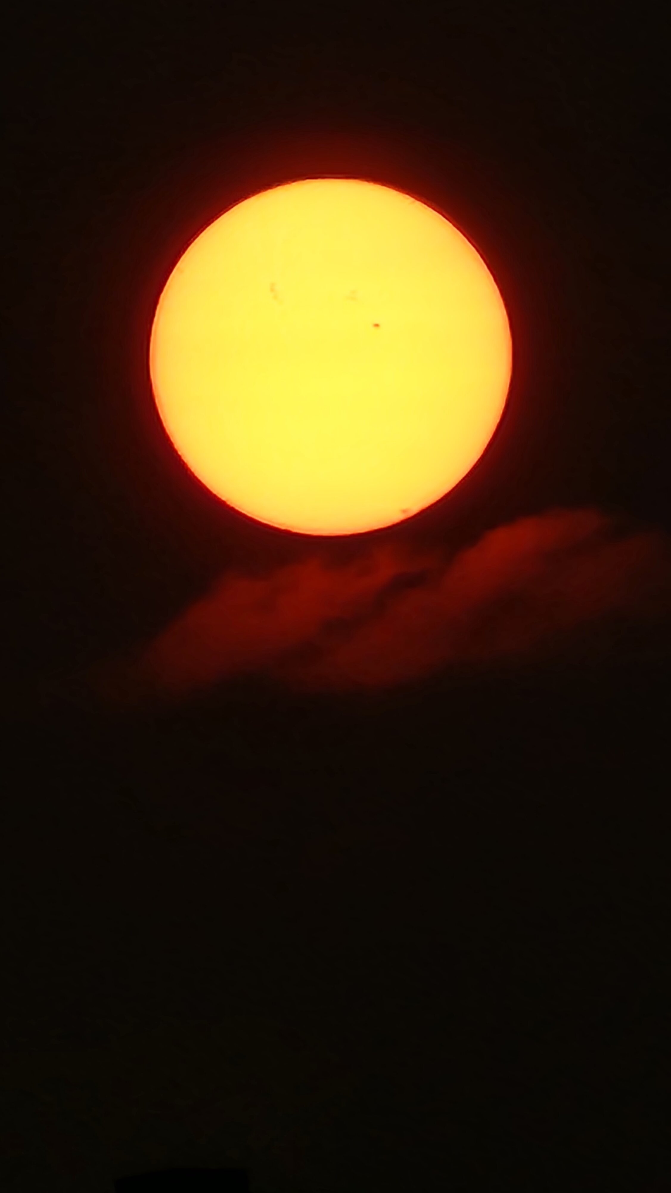
Can see sunspots again

-
7
-
-
59 minutes ago, Brian5671 said:
it's cheap!
their offseason
-
3 hours ago, BxEngine said:
Little bumpy over the atlantic on our flight to Aruba, past most of it now. Be a shame if saturday’s weather sucks and i get stuck there another night……
Went there for my 20th Anniversary in late March. It was my first time there. Loved it and can't wait to go back.
-
1
-
-
26 minutes ago, steve392 said:
Does anyone know how you can view weather underground weather station's precip history for individual stations? Trying to find rainfall for the new milford, nj area the july 15th into the 16th overnight hours.
There isn't a station too nearby, but this can give you a decent estimate. Looks like around 2.5".
-
18 minutes ago, Allsnow said:
Radar looks good to our sw
New Brunswick area about to get a nice heavy rain. That batch missed to the SE here. .20" on the day
-
2
-
-
.07" missed to my south
-
.60" total on the day
-
-
11 minutes ago, Allsnow said:
The stuff behind the line starting to break up. Will need stuff to form in front of it to get more then 1 inch
Nearing 1" by me now with that stuff in front of the main line
-
1
-
-
2 hours ago, nw baltimore wx said:
World is on fire.
What is the timeframe used when making these maps? Do they update it like the temp charts (1990-2020)?
-
On 7/5/2023 at 5:14 PM, Newman said:
Made it to around 92 here in Fleetwood. Some slow moving pop up storms forming over the coastal plain and Philly. Weak steering flow, humid/moist atmosphere, and convective T reached means you get these typical summer time pop ups. Not widespread in nature today
On another note, I will finally be moving to Wyoming in less than 3 weeks to continue my education and get my PhD. It's been a pleasure to be apart of the Philly subforum here, I don't think I'll be back east any time soon! But I'll still be posting here occasionally, can't escape your home roots
Congrats Newman, way to go!
-
17 hours ago, mitchnick said:
The blurb that FPizz posted was mine from a Phillywx post. I included with my post the MEI values since 1979, so I will include them with this post. You can see from the MEI values, ALL strong events were greater than 1 at the May/June reading with 97/98 at 2.4. I haven't seen a graph for the RONI, and maybe I'm reading your post incorrectly, but the MEI this year clearly does not stack up with past super el nino events thru May/June. In fact, this year's MEI matches closest to 02/03 & 09/10 to my aged eyes. I agree with your definition/purpose of the MEI, so maybe there's a lag, but it sure is odd that the readings so far have been far from previous strong events and much closer to weak Niños.
Fyi, if anyone is looking for a 1 stop site for Enso modeling/conditions, this would be it:
http://www.stormsurf.com/page2/links/ensocurr.html


Thanks! I didn't even realize you were on the board, lol. I was impressed by it so wanted to run it by the minds here. Thanks for posting!
-
 1
1
-
-
https://www.extremeweatherwatch.com/cities/newark/yearly-days-of-90-degrees
For those that want to track Newark 90 degree days
-
89/76/100
-
I saw this posted elsewhere about MEI:
The MEI for May/June number just came out at +.2. Since 1979 and NO strong Niño was under +1 at this point. In fact, the only Niños that were lower than this year since 1979 were WEAK (79/80, 04/05, 06/07.)
Sooooo, unless some magic occurs real fast unlike anything in the past 43 years, we'll be lucky to see a moderate Niño according to the MEI.
Here's a link to Ninas/Niños if you want to see for yourself.
https://origin.cpc.ncep.noaa.gov/products/analysis_monitoring/ensostuff/ONI_v5.php
Just throwing this out since you guys know way more than me about this.
-
Brief shower today that barely wet the ground, otherwise 0.00
-
85 with a 74 a dew.
-
2 hours ago, snowman19 said:
Paul Roundy thinks this is going to become a super event, less than an hour ago:
It might but it might not. I can do that too.
-
1
-
 1
1
-
 1
1
-
-
1.38" all total here. @Poker2015 about 3 miles from me across town got over 2".
-
6 minutes ago, Poker2015 said:
You beat me that one, only .3" from it here
About time! lol
-
17 minutes ago, Stormlover74 said:
It's warned but seems to be weakening
That heavy stuff you experienced earlier skirted me a bit. This one was pretty nice. Non stop lightning and thunder and .40" of rain in 15 min.
-
2
-
-
Decent looking storm heading into Southern Somerset then probably Middlesex County
-
1
-


July 2023
in New York City Metro
Posted
.02" here.