tamarack
-
Posts
16,506 -
Joined
-
Last visited
Content Type
Profiles
Blogs
Forums
American Weather
Media Demo
Store
Gallery
Everything posted by tamarack
-
I grew up in Morris County, where that 37.7 foolishness is located. However, if the current models verify I could see then getting 15-20. (While I might get 1/2") Still looking good for Metro Baltimore and Phin. When I lived there it was total panic with everything shutting down for 4 or 6". Spent 2 years there while at Hopkins. 64-65 had nothing beyond 4-5" and things went okay. They got 7-8" on Jan 27, 1966 and that slowed things more, but when 15" and 50 mph winds followed 3 days later the city shut down. I think Orleans Street was the only E-W road open and Charles Street the only N-S though the adjacent St. Paul opened the next day. However, 10 days later side streets in the Hopkins area (2900 Charles) were still snowbound.
-
Active mid December with multiple event potential
tamarack replied to Typhoon Tip's topic in New England
Plenty of changes from now to then, but at present my old NNJ haunts get 18" while we get a dusting here and the snow-loving grandkids (who only saw white ground last winter when they visited us for Thanksgiving) get a couple inches of slop and RA+. -
Active mid December with multiple event potential
tamarack replied to Typhoon Tip's topic in New England
Agree. Haven't seen 18z but 12z had maybe 0.2" of mess tomorrow night then nothing until a day 10 Grinch. -
As you should be, thanks to currents and drawdowns. Some years back, one of the Brochu family, with decades of experience riding in the area, was lost when he went thru the ice.
-
Not my favorite scenario, when my old NNJ digs get 18-20 while we repeat the 0.2" from Wednesday evening. Plenty of time to change - could get nothing at all.
-
And I have no a idea why the pic was reproduced on my post.
-
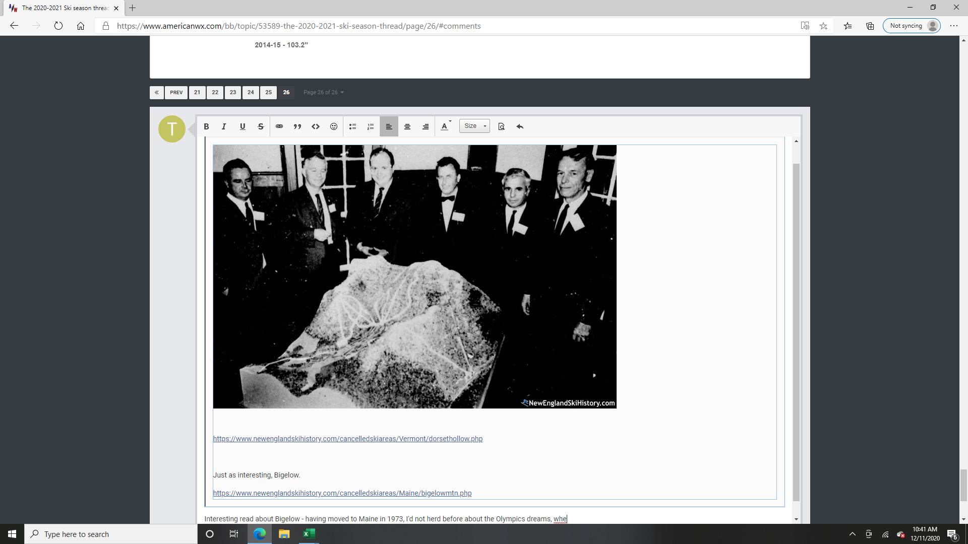
Since our agency has managed the Bigelow Preserve for 40+ years, I was quite interested in the article, and especially in the Olympics dreams, which were long dead by the time we moved to Maine in 1973. I voted for the Bigelow Act in 1976, and despite the capital "P", the Act states that the Preserve is to be managed for "recreation, wildlife and timber." Since the initial cutting late in fall of 1982, the Bureau of Parks and Lands has harvested over 160,000 cords, much of it from areas in view from those summit pics. Bigelow holds some of the highest quality hardwood timber in New England. A few comments: --The cited 10,540 acres represent the ecological reserve allocated in 2000, which covers the ridgeline down to 1,900' plus mile-plus width extensions to the property lines both north and south, so to include significant area in all ecological communities present. The total area at Bigelow is a bit over 37,000 acres, which started with the purchase from Flagstaff Corp and continued through multiple land trades, usually in exchange for scattered original Public Lots. --The Bigelow Lodge was built mainly to wine and dine prospective investors. The never built ski area lodge would've been larger and with the biggest windows facing the mountain rather than the lake as in the current building. It's now used mainly for training Maine Conservation Corp workers and as a warming hut in winter. --I chuckled a bit at the plans for marinas. Flagstaff is mainly quite shallow as it's an impoundment of the Dead River to store water for Kennebec River hydro at Bingham and Solon. There are very shallow flats, considerable submerged old stumps and varying water levels that make the lake hazardous for high powered boats. That plus the absence of a coldwater fishery pretty much leaves this 4th biggest of Maine lakes to small outboards and paddlecraft, a situation unique among th state's larger lakes.

-
Gray day - stratus hanging tough.
-
Least snowy of my 22 winters here with 48.2"- in fact only my 1st full Maine winter (73-74 in BGR) had less since we moved to Maine. 15-16 fights with 05-06 (52.8") for worst winter in the battle of midgets - with the mega-frustrating 09-10 also a competitor. Oddly, 05-06 and 15-16 produced NYC's 2 biggest snowfalls; we got 0.8" in Feb 06 and nada 10 years later. Even so the 06 storm stung a bit more as Gotham had more than 3 times as much as we had for Feb-Mar-Apr combined. It's also rock bottom for SDDs and it's not particularly close.
-
That's the one, and Hoot Mon is now The Brambles. Also noted The Cliffs is now single diamond - used to be advanced intermediate but with the "s" added to the name I guess it's more difficult.
-
Already had 2 events of 33-34° RA last month, over 1" precip in each. Why not have another?
-
Not lower FIS, but left of the Mountain lift (Glen Ellen's name for the long sl-o-o-w lift from the base) as one looks downhill. Most trail names there had a Scotch motif, with names like Black Watch, Inverness and Hoot Mon. Got onto the last by accident (missed the beginner trail turnoff) my first morning of ski week but before the classes were assigned and it was a disaster for someone barely past the snowplow - advanced intermediate with icy moguls and slabby powder in the hollows. I probably fell 20 times and the remaining $80 in Travelers Checks were left behind sometime during the process. However, it worked out okay, as I was initially placed in advanced stem but there too many, so they asked if anyone had been up the Mountain lift that morning and the 2 of us got bumped up to beginning parallel.
-
I learned parallel at the old Glen Ellen many years ago, on a super cheap January ski week - including gas, meals and lodging I barely cracked $100. A year later I returned as an intermediate skier and chickened out on the summit, taking the long way around rather than Upper FIS. Then I tried the narrow and twisty black diamond just left of the lower liftline and had a great run - conditions were excellent. That told me that the much steeper/much wider FIS was within my reach, but unfortunately we had to head home to NNJ after that run. (And the real scary trail that I'd never had tried was then called Scotch Mist, down the summit liftline - steep as FIS but narrow and with hard objects in the middle.
-
Those pics reminded me of clearing trails on state land in Gray/New Gloucester a few days after the 1998 ice storm. Not as many trees on the trail but they were bigger ones, sometimes cross-piled or under heavy tension, making the work challenging.
-
I switched this to the winter 20-21 thread, copying your post from about 30 minutes ago.
-
Copied 40/70 from the December thread. Oh, okay. Well, my point was that el nino winters are usually more back loaded for SNE than la nina, but the caveat being that that maybe mostly due to February. You may have a case for March temps, however, I am more confident that el nino is better for March snow in SNE than la nina. Obviously its subjetive...I am talking about SNE because I live here and its a NE subforum. Maybe NNE is different, at least for my place starting with 98-99 (SN expressed as percent of average): ENSO Mar. SN n Strong Nino 38% 1 (15-16) Mod. Nino 28% 2 Weak Nino 111% 4 La Nada 74% 7 Weak Nina 166% 4 (March 2001 is my snowiest month here - 55.5") Mod. Nina 108% 4 Strong Nina none yet
-
Maine was the slight outlier, as shown on the temp anomaly maps. March 2010 didn't get anywhere near 80 - topped out in mid 60s - but never got down lower than 11 and at my place had 28 AN days. 2012 had that incredible 6-day run of 20-28° AN but also was subzero on the 6th and had 11 days with BN temps. 2012 had 50% of average precip and 80% (14.6") of average snowfall. 2010 had 180% of average precip and 3% (0.6") of average snowfall. Maine was different because it was closer to the January retro-bomb that ate our winter.
-
Maybe. The didn't get much ice on Jan 8-9, 1998.
-
A bit rich for me. However, this brought back memories of when I was asst scoutmaster for our troop in NNJ, and we had the scouts up to Snow Valley in 1970 and 1971. Steeplechase was the fun slope, lots of room to play in though the constant side slope on the upper half added some challenge. Did not do the jump but somewhere have pics of one of the scouts launching then landing - poorly though unhurt. Was a bit sad when it closed, but with Bromley looming to the north and Magic/Stratton also nearby, it was in a tough spot. Had fun with that site, though I noted that Eaton Mountain in Skowhegan wasn't listed, nor was Craigmeur in New Jersey. The latter had only about 270' vertical and only natural snow back around 1970 but the trails were as smooth as a golf fairway so it didn't take much snow to be skiable. It was one of the few areas with the lodge at the summit. Saw some of Enchanted some years back when we looked for a workable trail route up Coburn Mt - the firewarden trail went straight up the fall line (and thru the ski area) and so was unsuitable for heavy use due to the inevitable trail wear and subsequent erosion. It's been widened a bit by the snowmobile folks and is advertised as the highest groomed trail in Maine. The ski area was actually on Johnson Mt Twp as they probably couldn't get permission to extend to the summit thru the state public lot on Upper Enchanted Twp - would've added 5-600' vertical. (Probably wouldn't have mattered - the place was in the middle of nowhere with zero related infrastructure nearby, thus a poor prospect.)
-
Chimney Pond is perhaps 110 miles farther north than Hermit Lake, which might affect their relative snowfall. Chimney reached 94" in 2017, knocking Farmington's 84" out of the lead it had held for 48 years.
-
December 5-6, 2020 Storm Observations and Nowcast
tamarack replied to Baroclinic Zone's topic in New England
Short memories? They had over 500k customers out from the Oct. 2017 gale; that's a few thousand more than in 1998, though in '17 most were re-powered within 2-3 days while the ice storm had many thousands dark for 2 weeks +. -
December 5-6, 2020 Storm Observations and Nowcast
tamarack replied to Baroclinic Zone's topic in New England
After seeing nearby cocorahs reports I can't be too critical of snow total verification. Chesterville, 7-8 miles to my SW, reported 2.9" from over 2" total precip, not quite half my 6.0 and with considerably more precip. 12 miles to my WSW, the Temple observer at 1220' had 11.5". 3 stations, all within less than a 30 minute drive from each other, and a 1-2-4 ratio of snowfall. -
Snowfall was surprisingly variable in southern Franklin County. Have not heard from the co-op, but 6 miles south in Chesterville only 2.9" was reported, at elev. 384'. Six miles west of the co-op I had 6.0" at 390' and 7 miles WNW in Temple - at 1220' - there was 11.5".
-
December 5-6, 2020 Storm Observations and Nowcast
tamarack replied to Baroclinic Zone's topic in New England
Had 1.5" of 9:1 snow (almost powder ) overnight, so storm total is 6.0" with 1.38" LE, plus the 0.10" RA at the start. Oddly there's more in the driveway, 5"+, than at the stake, 4". No drifting at all, just chunks blowing out of the trees which didn't impact either spot. -
December 5-6, 2020 Storm Observations and Nowcast
tamarack replied to Baroclinic Zone's topic in New England
4.5" at 9 PM, a bit more than I'd thought, but only a bit. However, I discovered why the forecast busted - nothing but flakes noon on and LE (without the 0.10" RA at the start) was 1.19" for a lovely ratio of 3.8. Even a wet 8:1 would've put me up near that Will measured. I think maybe that the flakes were so moist when they landed that they played flexible Tetris and self-compacted throughout the storm.