tamarack
-
Posts
16,509 -
Joined
-
Last visited
Content Type
Profiles
Blogs
Forums
American Weather
Media Demo
Store
Gallery
Everything posted by tamarack
-
Significant upper middle Atlantic S/CNE mix/snow potential Jan 3+
tamarack replied to Typhoon Tip's topic in New England
Had some significantly BN days Dec 15-20, probably helping to keep the mega-band to my south. Since then 15 straight AN days with only 12/30 even close to normal. Looks like we could be another 10-15 days of AN unless things change. Hope we don't challenge the 46 consecutive AN days in Feb-Mar 2010. -
Another cloudy flakeless day upcoming, maybe 3. Following the December trend; last month had 21 days I recorded as cloudy, 3 more than in any other month here. Would like some cold - no safe ice for drilling holes yet which is very odd for early January in central Maine. Jan minima running 12-14° AN.
-
6". Had been bare ground since 12/25. Only our 4th brown-ground Christmas in 23 years. (1999, 2006, 2015 the others)
-
WSW had 6-9 for our area and we just sneaked in with 6.0". Way nicer than the 6" of 4:1 stuff 4 weeks ago.
-
Measured 2.0" at 7 AM with 0.20" LE. Snow appeared to stop (very few very tiny things, maybe with frdz mixed) at noon so at 12:15 I measured total OG - 6.0" - and cleared the board again - 4.0" from 0.40" LE. Many years ago in Psych 101 the instructor stated that one who was perfectly normal in all aspects was the most abnormal of persons. Works the same for snowstorms? Light snow the past 45 minutes may accumulate a couple tenths on the board but I doubt it will increase total depth, just move the storm ratio below 10. Boosts season total to 17.3", about 2/3 the average for season to date.
-
Fat finger, not fat snow.
-
2.0" of 10:1 powder at 7 AM, temp in low 20s. Was light at 7 but now moderate just like Ekster said - best snow 12z-16z. Good chance we land in the 609" forecast, though hearing that the warm nose at H7 had reached GYX by 7 was ominous.
-
Sam here, in centimeters.
-
Dec (Edit: Jan1/..2 ) multi-faceted ptype mess potential...
tamarack replied to Typhoon Tip's topic in New England
We take - looks better than our 1.9" on Dec. 17. -
We paid our shovel/snowscoop dues in Ft. Kent, avg winter 130"+. (And again for 2008-09 and 09-10 when our Craftsman Trac-26's power transfer mechanism wore out - would travel backwards but not forwards. Took it apart, found the ruined parts, unable to find anyone that made them 25+ years after My dad had bought the critter.) I siphon as much as possible back into the gas can, then run the blower dry. Next fall, gas it up, hit the primer 3X and it usually fires up on the 2nd-3rd pull. (Only 10 yr old, though.) Has cord for electric start but I've never had to use it. The Craftsman wouldn't pull-start when much under 20°.
-
Happy New Year - one than can't (can it?) be worse than 2020. December 2020: Avg high: 32.9 +2.3 max 56 on the 1st Avg low: 19.3 +6.2 min -5 on the 19th Mean: 26.1 +4.3 The low of 44 on the 1st is my highest minimum in December. 2nd place is the 43 on Christmas. The 54/43 on the 25th was +28.8, highest AN for any day since moving here in May 1998. (now 2nd: 27.8 on 3/22/2012) Precip: 5.85" 1.36" AN Biggest day: 2.54" on the 25th, my greatest one-day precip in December. Yay Grinch! Snowfall: 9.2" 9.8" BN. Largest event was 6.0 of 4:1 stuff on 5-6. OND snow total of 11.3" is 47% of average. 2020 - the year: Avg temp: 42.9 +1.35. Hottest: 90 on 6/20. Coldest: -28 on 2/15 Precip: 46.54" -2.66" Wettest month was Dec and day, 12/25. Driest was September, 1.29" with 1.14" coming on the 30th. The 6 weeks 5/17-6/27 had only 0.65". The 17 days 6/28-7/14 had 8.33". feast or famine Snowfall (Calendar year): 72.1", lowest since 2010. Biggest storm: 10.3" on 3/23/24 Tallest pack: 21" on 2/19. (Avg tallest is 30"; median 27")
-
Dec (Edit: Jan1/..2 ) multi-faceted ptype mess potential...
tamarack replied to Typhoon Tip's topic in New England
My 0.1" overnight kept the ground white almost until noon. Biggest snowfall since 12/20. I think that continuous snow cover begins tomorrow night. -
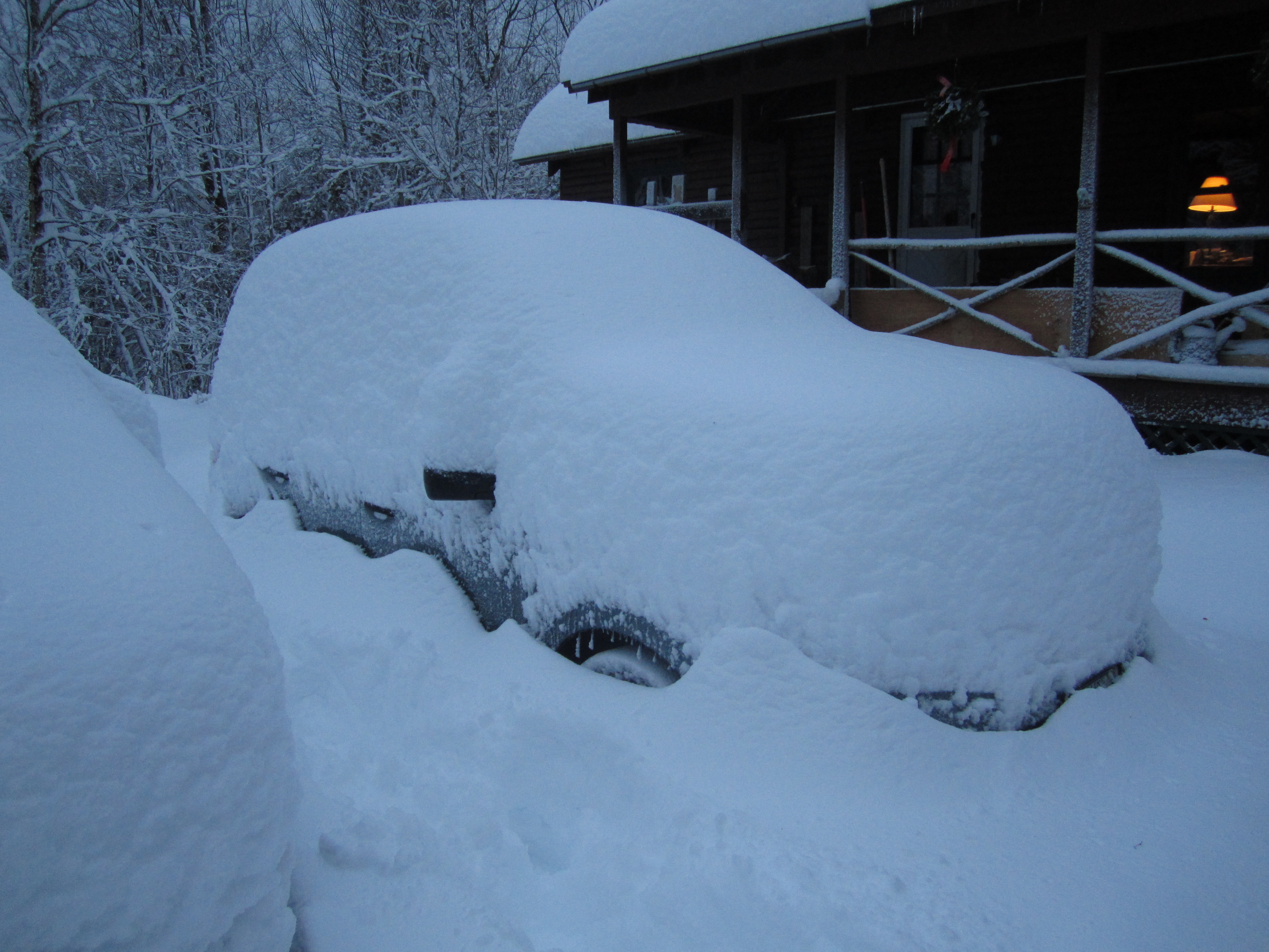
Same storm (21"): Our Subaru Forester, well buried.

-
Dec (Edit: Jan1/..2 ) multi-faceted ptype mess potential...
tamarack replied to Typhoon Tip's topic in New England
I remember only one significant ice storm that didn't begin with frozen precip, usually SN but a couple times IP. That one event, Dec. 11-12, 1970 in NNJ, produced the weirdest looking lawns ever, with grass blades encased in 3/4" ice and not a speck of snow on the ground before or during the event. Probably my #3 ice storm, vying with Dec 1983 in Fort Kent, but orders of magnitude below 1953 and 1998. -
Good thing, after the grinchiest Grinch ever. Nice going from modeled cutter/whiff to perhaps 2 decent snow events.
-
Had 10" in NNJ, with pulses of heavier snow the evenings of 23rd and 24th, and flurries/S- between. Not all that many Christmas Eve/Day snow memories - 1961, 1966 (best one, with thunder), 1978 (Fort Kent) and 2017.
-
Dec (Edit: Jan1/..2 ) multi-faceted ptype mess potential...
tamarack replied to Typhoon Tip's topic in New England
Pure sleet that one can shovel, meaning w/o ZR mixing in, has for me always melted out very close to 3:1, similar to snowmaking product. A situation like the Fort Kent ice storm in mid-December 1983 was different. At the end of that event, our yard had a 3" crust (atop a solid 24" pack) consisted of a 1/2" layer of clear ice sandwiched between 1.25" layers of ZR-welded IP. It was very difficult to get a core (had to somehow have the tube I use melt its way thru) and it came to 1.9". Thus the 2.5" of IP-stuff had 1.4" LE for slightly less than 2:1. (And with one half-decent snowfall on it, that crust would hold a running bull moose.) -
And we had our warmest Christmas since moving to Maine in 1973. Have to go back to 1965 in NNJ to find one warmer. Irony is fun.
-
EPO/Machias payback for 2014-15? I'm also skeptical about those low depths along the Frontier area from Jackman to St.-Pamphile, especially since the Allagash corridor a few dozen miles east is credited with 2-3 times as much.
-
Had a few graupel flurries this morning, partly to mostly cloudy this afternoon. Other than some small piles, there's zero snow cover here. Rivers have peaked and are on the downslide, with the Kennebec in AUG cresting on the midday high tide at nearly 4' over flood. (Big floods like 1987 overwhelm the tide cycle, for about 3 days in that one.) Decided to move the max-min after the heat pump was installed, as the exhaust is about 3' from the old site. The installer said the pump's exhaust would affect the thermometer when set for AC and that's likely to be about 95% of our use.
-
Another 0.13" late last evening for a storm total of 2.68". Yesterday's 54/43 was 29° AN, the greatest positive departure I've recorded in 22+ years here, topping the +28 on 3/22/2012. The low of 43 was 33° AN.
-
2.30" thru 4 PM but wind thankfully underperformed here - maybe gusted into the 30s. Snow down to traces, which should all be gone before sunrise - worst pack-eater RA since Jan 1995. Lots of warnings for minor/moderate flooding around central Mine and NH , with the Kennebec forecast to crest more than 5' above flood stage in Augusta - not just washing the parking lots but may get into some businesses on the river side of Water Street.
-
Of the 4 "winter" months here, January has had the fewest storms of 10"+ with only 5 (DFM have 8,10.12, respectively) but 3 of those 5 have come during the month's 1st 5 days. SSS
-
That post implies that he thinks everybody in our age class is horrible while he's wonderful. Must've been triggered by this Grinch storm.
-
0.64" at 7 AM, windy but not making the house creak (yet). 50°, compared to my average low of 10° on 12/25. Pack down to 2", probably won't survive into the afternoon. Grinch has out-Grinched himself.