

MANDA
-
Posts
3,008 -
Joined
-
Last visited
Content Type
Profiles
Blogs
Forums
American Weather
Media Demo
Store
Gallery
Everything posted by MANDA
-
Pretty impressive satellite picture this morning. https://www.meteo.psu.edu/ewall/PSUGOES_PA2/loop30v.html Raining heavily here attm.
-
My focus now turns to actually wanting warmer weather and avoiding Spring and Summer Drought. Winter is over and I'm ready to move on.
-
The howling winds from the overnight have died down but it is still kind of gusty out there. Event rainfall total = 1.05" (.68" and .37"). Total Precipitation for February = 2.45". Y.T.D. = 10.67". Snowfall February = 11.5". Snowfall for Season to date = 22.2".
-
Thanks Don. My guess would have been #4 or 5. Real close to tying at least for #5.
-
Hi Don, What does the latest "Winter Futility Chart" look like with just 1.5 days to go before meteorological winter is finished?
-
Rainfall last 24 hours .66". Snow gone except for plowed mounds.
-
With the way the warmth over performs I'll take the over on those temps.
-
A reading from the book of Revelations. The end of days are near. Repent.
-
Ya think! Some real diehards this season. Some are STILL hanging on for dear life thinking their forecasts will be vindicated with a cold and snowy March.
-
Yeah, the hose finally got turned off. We'll see where we go from here.
-
If you watch the video you will hear how he had to fight management at WCBS to a degree to educate people and not dumb things down. You'll never see anything like that today. Most of the time he had to do it in under 90 seconds. He was also great at NJ101.5. I suspected at the time he was shown the door but he confirmed that last night on the podcast. Wake up at mid-night, drive an hour to work to start at 2am then leave for home at 10am. For 25 YEARS! He loved what he did.
-
Here is a link I had sent to NJ101.5 that I had come across years ago. Still have great audio clips of Alan from his TV days, Hurricane Belle, Blizzard of 78 and some other events. https://nj1015.com/vintage-footage-of-weatherman-alan-kasper-video/ Only a few good on air Meteorologists around today, but Alan was one of a kind in his delivery.
-
Off topic for this thread but I'll post it here since the weather is quiet. For those of you who were fans of Alan Kasper back in the day you will like this. A friend of mine sent me this link so I am passing it along. Lots of great memories. I worked weekends at WCBS late 1983 to late 85 and Alan had left by then. Wish I had gotten to meet him. A Legend. What came after him not so much. Here is link:
-
Same here....lots more bird activity than usual for this early in the season. I think most I've seen at this time of year.
-
Wintry looking visible satellite image this morning.
-

2/13 Significant/Major Winter Storm Discussion & Observations
MANDA replied to Northof78's topic in New York City Metro
All done here. Just flurries now. Finished with an even 9”. -
2/13 Significant/Major Winter Storm Discussion & Observations
MANDA replied to Northof78's topic in New York City Metro
Last band coming through. Moderate snow now. -
2/13 Significant/Major Winter Storm Discussion & Observations
MANDA replied to Northof78's topic in New York City Metro
Looks nice out there. Still light snow. -
2/13 Significant/Major Winter Storm Discussion & Observations
MANDA replied to Northof78's topic in New York City Metro
Snowing lightly. 8.6” otg. Light snow for a bit longer but it is wrapping up soon. -
2/13 Significant/Major Winter Storm Discussion & Observations
MANDA replied to Northof78's topic in New York City Metro
28 and 5” otg. Heaving snow attm. -
2/13 Significant/Major Winter Storm Discussion & Observations
MANDA replied to Northof78's topic in New York City Metro
29.5 and moderate snow now -
2/13 Significant/Major Winter Storm Discussion & Observations
MANDA replied to Northof78's topic in New York City Metro
33 here. Light to moderate snow. Everything including road covered since it began about 30 min ago.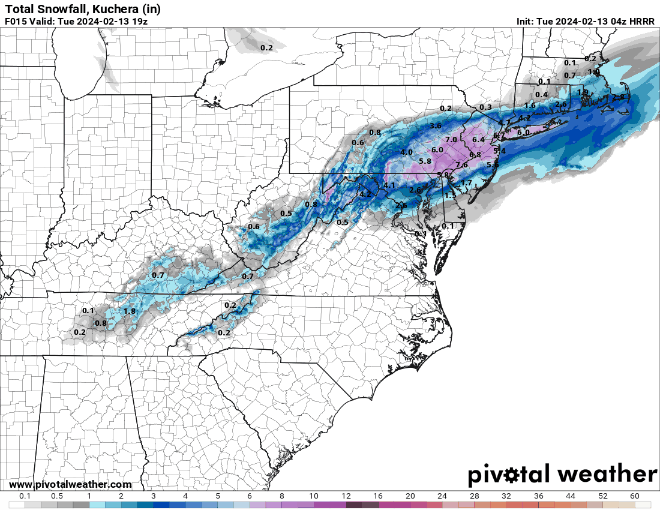
-
2/13 Significant/Major Winter Storm Discussion & Observations
MANDA replied to Northof78's topic in New York City Metro
Absolutely nuts. Stuff like this never used to happen. -
2/13 Significant/Major Winter Storm Discussion & Observations
MANDA replied to Northof78's topic in New York City Metro
Laughable if true. -
2/13 Significant/Major Winter Storm Discussion & Observations
MANDA replied to Northof78's topic in New York City Metro
They had to bump the numbers down along and north of I80. There was nothing left to support what they had going. Looks like much more reasonable map overall. I would tend to lean to the lower end of the range for 78 north.


