Snowncanes
-
Posts
169 -
Joined
-
Last visited
Content Type
Profiles
Blogs
Forums
American Weather
Media Demo
Store
Gallery
Everything posted by Snowncanes
-
I agree with RAH this is a classic cold chasing moisture. Just like 3 weekends ago. I’ll believe it when I see it lol. Youre not sucking me in again
-
Color me skeptical with a cold chasing moisture setup, but I suppose we’ll see. With exception to the climo favored areas of course
-
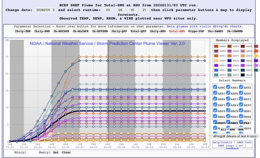
The plumes for RDU were all over the place. As late as 03z Saturday they had a range of 1-25” for RDU with a mean of 10”. So yes technically in the range but I could’ve thrown a dart 100 yards and been as close lol
-
Yup, can confirm, had 1.75” close to downtown Cary. Had both the band from the west and the band from the east stop on our doorstep lol. But I’m hopeful for just one more something. Maybe I just need to move to Vermont
-
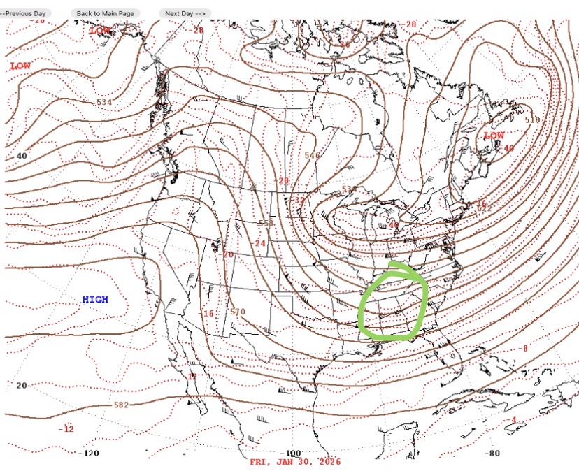
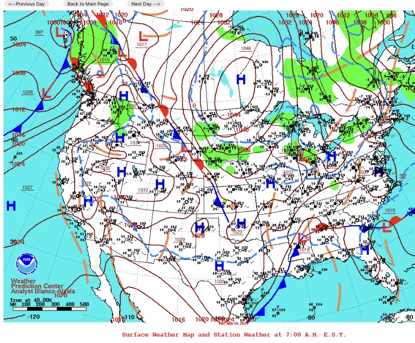
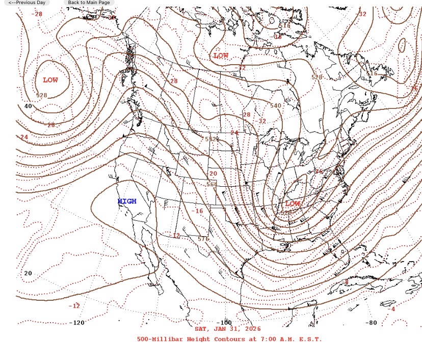
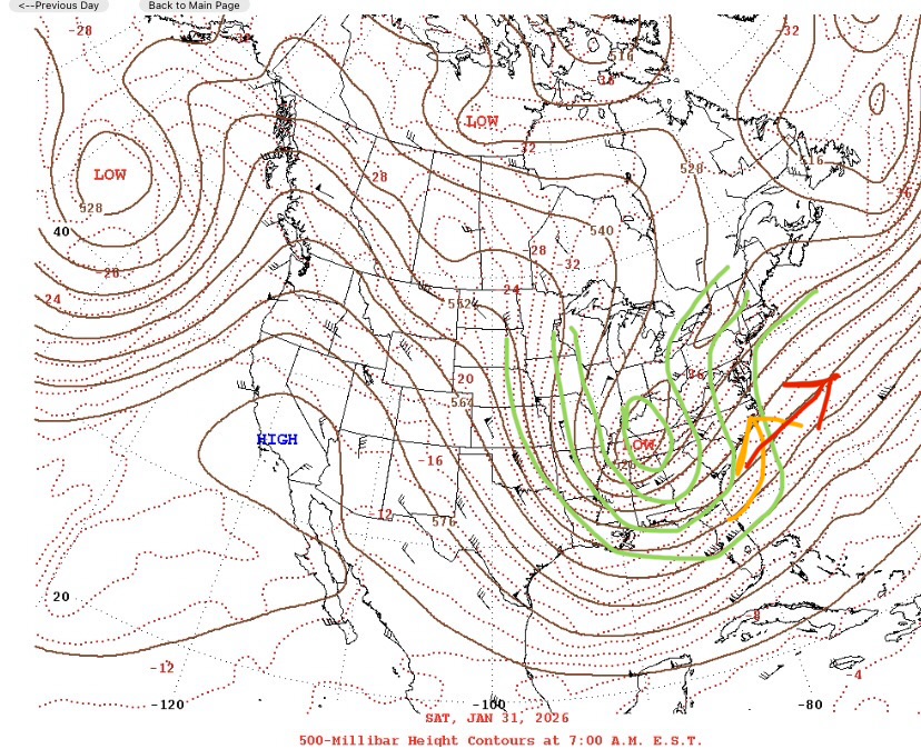
These are the 500mb and surface maps for the past two days. You can see a surface low on the map in conjunction with the shortwave (the slight bump in isobars) Ive circled in green on Friday. This frontal boundary is how our coastal storm developed. The shortwave rode up and around the 500mb low as it cut off and dove south from the upper Midwest. When these features combine and are vertically stacked the 500mb low can feed the surface low its energy and transfers down to the surface low. That was our expansion of precip back over eastern NC last night. If the 500mb low had been a little quicker to tilt, it would have made that shortwave (our surface low) ride a little closer to the coast instead of going more out to sea. This would have made the ULL and surface low interact more and “phase” earlier to create the same storm it created out in the Atlantic 100 miles closer to shore, thus bringing the whole precip shield that much west. edit: added a roughly drawn phone made example of the upper low negatively tilting. The orange line is what the upper level flow would have been like if it was negatively tilted and the red line is what it was. Much more progressive instead of amplified like the last storm was.
-
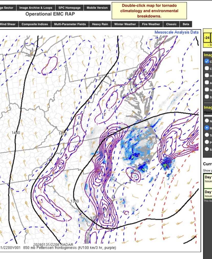
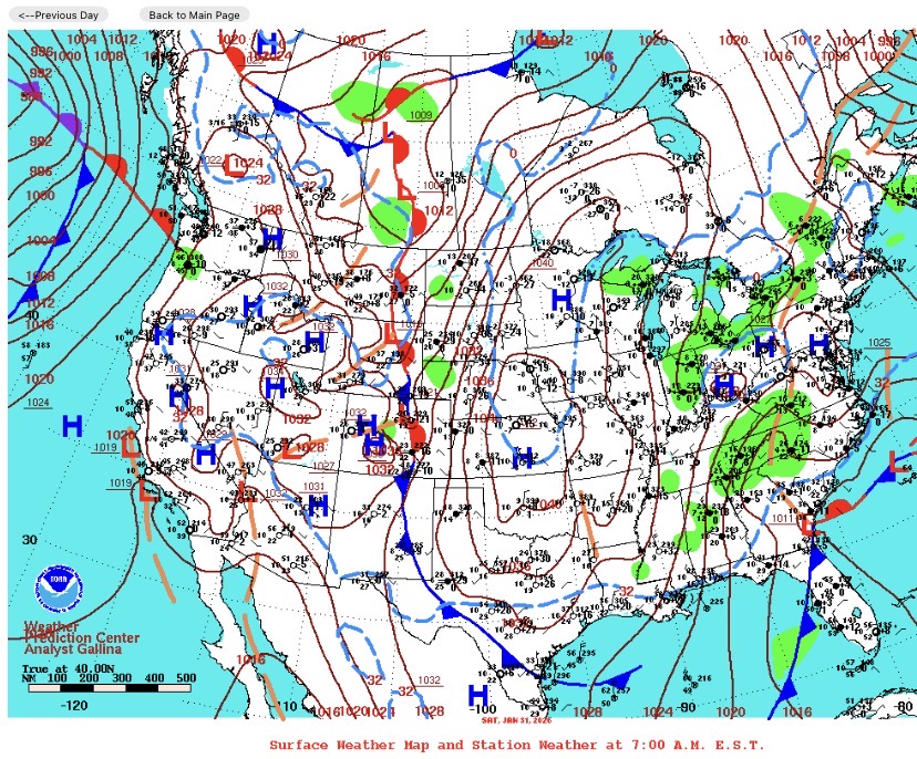
This was more of a miller A. A miller B has a surface low in the Appalachian region that transfers usually around the Virginia coastline. You had the ULL that gave most of western NC a good snow, and you then had the coastal that hit eastern NC. Storms/rain/snow are created with lift, and when you have two areas of strong lift, the area in between has the air particles sinking. This is called subsidence. This is what the “dry slot” was. It wasn’t actually dry air really, it was more of a lack of lift and thus not creating the precip needed. If the coastal had formed closer to the coast and the ULL had tilted negatively sooner and interacted more with the surface low, the precip shield from the coastal and ULL would have merged better and filled in (like it did later in the evening). Unfortunately these two did not interact as much as needed for central NC and the transfer of energy basically skipped over central NC and did not provide any lift, or vertical velocity. Feel free to ask if you have any questions or if I didn’t explain it well enough.
-
Yup im right in that light blue circle in the map NWS put out. We got just a hair under two inches. Just absolutely brutal seeing everyone with like 8”+. Ive been waiting 20 something years for a storm like that
-
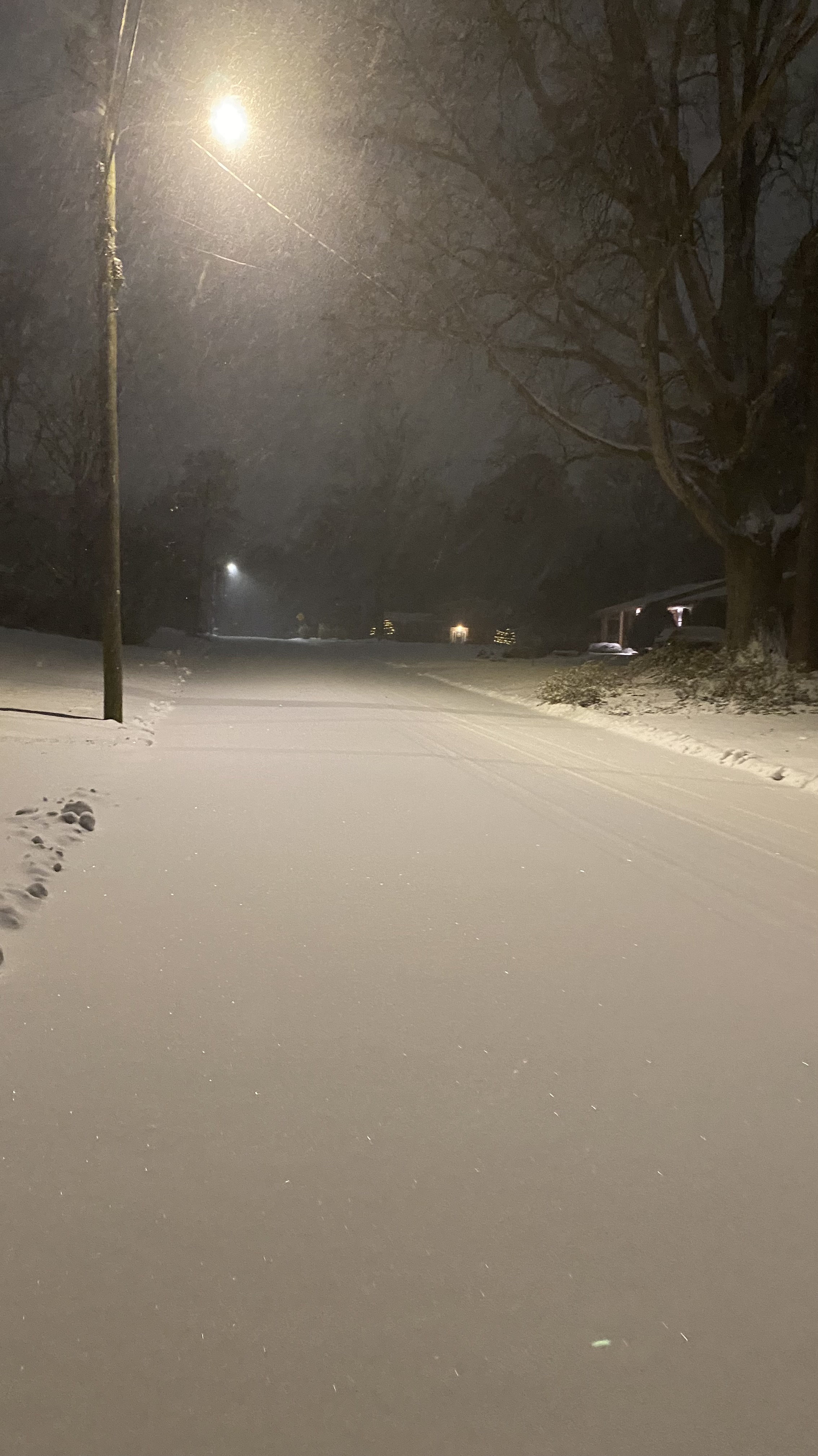
Oh yeah, meant to add a pic.
-
Popping in from the SE forum, that dry slot was absolutely horrendous today. I’ve got an inch on the ground here in Cary (SW Raleigh metro) maybe 1.5. Absolutely crushing watching everyone around getting 6-8+. One person in our forum even got 6” 15 miles to my east in a heavier band. Would’ve much rather been in y’all’s shoes. Good luck on the one Thursday.
-
looks like a cold chasing moisture setup to me. Maybe a hit for NE NC like usual in these setups
-
The “I bring the mojo” Jan 30-Feb 1 potential winter storm
Snowncanes replied to lilj4425's topic in Southeastern States
Right there with you. Happy for everyone that cashed in but man am I bummed. I think you and I got the least in the whole state lol -
January 30th- Feb 1st ULL and coastal storm obs
Snowncanes replied to JoshM's topic in Southeastern States
Man im jealous. 15 miles west of you and have an inch in Cary. -
January 30th- Feb 1st ULL and coastal storm obs
Snowncanes replied to JoshM's topic in Southeastern States
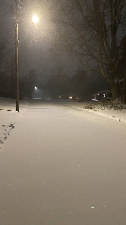
1” here in Cary. At least it made everything look pretty
-
Literally spending his evening crying about people crying about getting shafted. Let us vent in peace. That’s what this thread is for. Mets all say this is the craziest subsidence they’ve ever seen in their X# of years doing this.
-
Man this is getting annoying… this is the cliff diving thread and everywhere else immediately around us is getting 6” and up and I barely have enough to blow off the car
-
January 30th- Feb 1st ULL and coastal storm obs
Snowncanes replied to JoshM's topic in Southeastern States
Here’s my coating in Cary.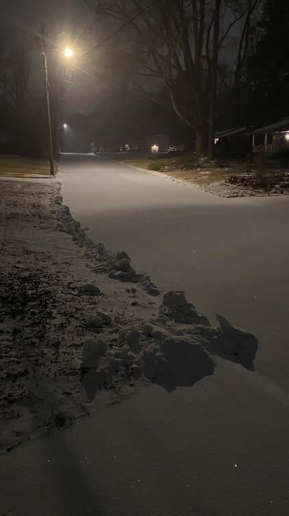
-
My uncle in Lexington sent a pic of 14” of snow. My friend in new Bern sent me a video of a blizzard. I have a coating.
-
January 30th- Feb 1st ULL and coastal storm obs
Snowncanes replied to JoshM's topic in Southeastern States
I mean… it’s snowing I guess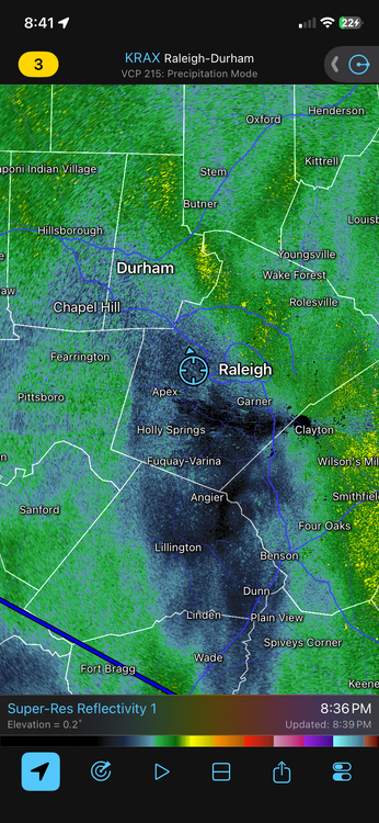
-
The “I bring the mojo” Jan 30-Feb 1 potential winter storm
Snowncanes replied to lilj4425's topic in Southeastern States
Frontogenesis band moving into wake county now. Dont fret
-
The “I bring the mojo” Jan 30-Feb 1 potential winter storm
Snowncanes replied to lilj4425's topic in Southeastern States
Im not really complaining this time around yet, but that snow 2 weekends ago was 15 minutes of mood flakes for me. Then last weekend was maybe .3” sleet and .1 zr. And now this. -
The “I bring the mojo” Jan 30-Feb 1 potential winter storm
Snowncanes replied to lilj4425's topic in Southeastern States
I agree, everywhere has been getting 1/2”-1” rates all day. Once that builds in here all we need is 3-6 hours of snow to get 3” out of it. Ratios are super high, and it will accumulate quickly with the sun down and temps in the teens. Patience is key. I know it sucks right now -
The “I bring the mojo” Jan 30-Feb 1 potential winter storm
Snowncanes replied to lilj4425's topic in Southeastern States
Im in the area too. Snowed for about 10 minutes and that’s all I’ve seen. It sucks, especially seeing everyone else in the state with 5”+. But this thread isn’t for complaining for 3 pages, it’s for the info of the storm. Which btw our ULL went neutral and will probably go negative in the next hour and deepen the surface low. Theres still time. -
The “I bring the mojo” Jan 30-Feb 1 potential winter storm
Snowncanes replied to lilj4425's topic in Southeastern States
Please take this to the cliff diving thread. It’s been like 30 posts. He literally says in the post his reasoning we will still see snow, and when, and y’all aren’t seeing it fall outside right this minute so you’re jumping off the cliff -
The “I bring the mojo” Jan 30-Feb 1 potential winter storm
Snowncanes replied to lilj4425's topic in Southeastern States
As the ULL comes ever so slowly east, this band of FGEN should give us in Wake county some good rates. We are right on the edge now, as we see the radar beginning to light up over W wake county, Durham, Chatham, and orange. I think we might actually be in a good spot as long as this band of FGEN keeps trekking east like it should.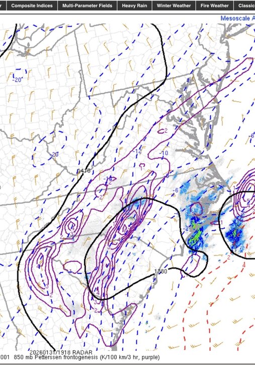
-
January 30th- Feb 1st ULL and coastal storm obs
Snowncanes replied to JoshM's topic in Southeastern States
Light flurries in Cary. Might finally be starting lol