

Snowncanes
-
Posts
169 -
Joined
-
Last visited
Content Type
Profiles
Blogs
Forums
American Weather
Media Demo
Store
Gallery
Everything posted by Snowncanes
-
The “I bring the mojo” Jan 30-Feb 1 potential winter storm
Snowncanes replied to lilj4425's topic in Southeastern States
Because everybody is (understandably) focused on their backyard and it dry slots RDU fairly significantly. Which is where a lot of this board (me included) live lol -
The “I bring the mojo” Jan 30-Feb 1 potential winter storm
Snowncanes replied to lilj4425's topic in Southeastern States
What he means is everyone go stand outside with a thermometer and wait until things start falling from the sky instead of doomscrolling every model run haha -
The “I bring the mojo” Jan 30-Feb 1 potential winter storm
Snowncanes replied to lilj4425's topic in Southeastern States
I think it looks a good bit different at H5. Closes off the upper low much earlier, is more west, and goes neutral earlier. Blossoms the precip shield over NC much better and even takes care of our Atl people a bit. To me this is the thing we are looking for the most. How early can we get that low to close off and go negative. Makes all the difference in the world. -
The “I bring the mojo” Jan 30-Feb 1 potential winter storm
Snowncanes replied to lilj4425's topic in Southeastern States
Im not super familiar with the smaller towns in Georgia haha my bad. -
The “I bring the mojo” Jan 30-Feb 1 potential winter storm
Snowncanes replied to lilj4425's topic in Southeastern States
Athens east unfortunately. At least verbatim. Upper low still closes off too late for y’all atlantans -
The “I bring the mojo” Jan 30-Feb 1 potential winter storm
Snowncanes replied to lilj4425's topic in Southeastern States
NAM looking better through 36 at H5. Digging more and a tad west -
The “I bring the mojo” Jan 30-Feb 1 potential winter storm
Snowncanes replied to lilj4425's topic in Southeastern States
Yeah… I think it’s overdoing it though. CAM’s will probably resolve it better but I feel like a low that strong is going to throw precip back. And if we can get even just a slightly earlier negative tilt it will help transfer the energy earlier and throw the precip back over the piedmont better. The gap is from the ULL snow and the energy skipping over and then the low bombing out and so that area misses the brunt of the ULL and of the coastal. -
The “I bring the mojo” Jan 30-Feb 1 potential winter storm
Snowncanes replied to lilj4425's topic in Southeastern States
Solid run for most of the forum. This is 10:1 map, i don’t have kuchera. Kinda weak with the precip as it bombs out. Would expect it to throw a little more back than it did but we’ll see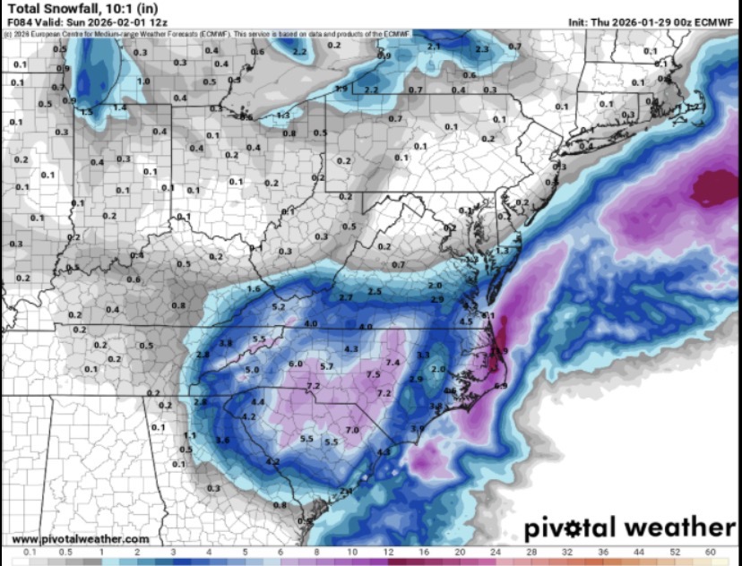
-
The “I bring the mojo” Jan 30-Feb 1 potential winter storm
Snowncanes replied to lilj4425's topic in Southeastern States
Goes neutral at 66, negative over sc/ga border at 72. Precip looking solid. 995 low about 30m SE hatteras at 72 -
The “I bring the mojo” Jan 30-Feb 1 potential winter storm
Snowncanes replied to lilj4425's topic in Southeastern States
H60, digging more than gfs, better tilt. Looks like it’ll be good -
The “I bring the mojo” Jan 30-Feb 1 potential winter storm
Snowncanes replied to lilj4425's topic in Southeastern States
It’s moving again finally. Got 54. Looks similar to gfs so far at H5 -
The “I bring the mojo” Jan 30-Feb 1 potential winter storm
Snowncanes replied to lilj4425's topic in Southeastern States
Stuck at hr48 again… anyone else? -
The “I bring the mojo” Jan 30-Feb 1 potential winter storm
Snowncanes replied to lilj4425's topic in Southeastern States
And the euro is off. Fingers crossed! -
The “I bring the mojo” Jan 30-Feb 1 potential winter storm
Snowncanes replied to lilj4425's topic in Southeastern States
18-1 ratios on that. Insane. Rdu gets 1” qpf and the bullseye got 1.5” -
The “I bring the mojo” Jan 30-Feb 1 potential winter storm
Snowncanes replied to lilj4425's topic in Southeastern States
Also a better tilt and closed off earlier. Looks like a weenie run -
The “I bring the mojo” Jan 30-Feb 1 potential winter storm
Snowncanes replied to lilj4425's topic in Southeastern States
One thing Ive noticed is the models are having a very hard time figuring out where this surface low consolidates. The rgem has literally 6 different LP mins simultaneously. Precip shield will respond to whichever it can consolidate around, but I doubt there will be 6. -
The “I bring the mojo” Jan 30-Feb 1 potential winter storm
Snowncanes replied to lilj4425's topic in Southeastern States
AIGFS not much change in anything. Maybe some minor tweaks but nothing of note -
The “I bring the mojo” Jan 30-Feb 1 potential winter storm
Snowncanes replied to lilj4425's topic in Southeastern States
I know we all hate on the GFS and theres still time for things to go wrong but it’s been remarkably consistent for this storm. Gotta give props where they are due. -
The “I bring the mojo” Jan 30-Feb 1 potential winter storm
Snowncanes replied to lilj4425's topic in Southeastern States
ICON caves. Still room for improvement but it took a big jump towards consensus at 5H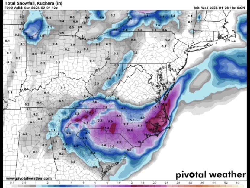
-
The “I bring the mojo” Jan 30-Feb 1 potential winter storm
Snowncanes replied to lilj4425's topic in Southeastern States
ICON might finally be getting a clue. A good bit further SW with a better tilt axis at 72hr -
The “I bring the mojo” Jan 30-Feb 1 potential winter storm
Snowncanes replied to lilj4425's topic in Southeastern States
NAMed. edit: got beat by 2 seconds again. But still snowing over most of the Carolina’s here
-
The “I bring the mojo” Jan 30-Feb 1 potential winter storm
Snowncanes replied to lilj4425's topic in Southeastern States
NAM slight changes through 54. Heights up a little over Ohio and just a touch southwest with the energy over Missouri -
The “I bring the mojo” Jan 30-Feb 1 potential winter storm
Snowncanes replied to lilj4425's topic in Southeastern States
Cant pull the rug if the model never runs -
The “I bring the mojo” Jan 30-Feb 1 potential winter storm
Snowncanes replied to lilj4425's topic in Southeastern States
At this rate the NAM is going to be running when the euro finishes its run -
The “I bring the mojo” Jan 30-Feb 1 potential winter storm
Snowncanes replied to lilj4425's topic in Southeastern States
Euro is running


