Snowncanes
-
Posts
169 -
Joined
-
Last visited
Content Type
Profiles
Blogs
Forums
American Weather
Media Demo
Store
Gallery
Everything posted by Snowncanes
-
The “I bring the mojo” Jan 30-Feb 1 potential winter storm
Snowncanes replied to lilj4425's topic in Southeastern States
Just a hypothesis, but maybe since they’re partially based on analogs, they tend to “moderate” things. We saw the same thing with the strong HP last storm. The physics models are allowed to run wild with whatever dreams they want to come up with and the AI are held back by their data ingested. -
The “I bring the mojo” Jan 30-Feb 1 potential winter storm
Snowncanes replied to lilj4425's topic in Southeastern States
Euro AI looks like gfs with the upper low. Looks to be a good run incoming! -
The “I bring the mojo” Jan 30-Feb 1 potential winter storm
Snowncanes replied to lilj4425's topic in Southeastern States
Regular GFS closes it off in Illinois at hr 66. Looks to be fairly similar if not slightly east of AI. But still a great look -
The “I bring the mojo” Jan 30-Feb 1 potential winter storm
Snowncanes replied to lilj4425's topic in Southeastern States
AiGFS has the low closing off further north like the RGEM. Dives it down through extreme NE Alabama. Neutral to slightly negative tilt too. Looks like a great run -
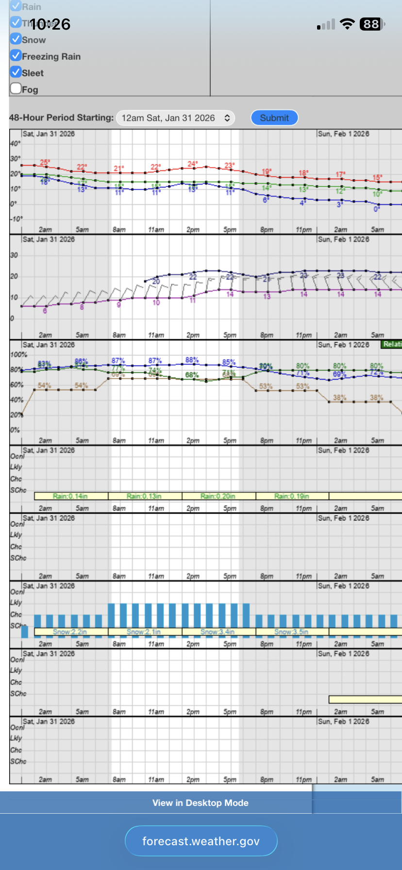
The “I bring the mojo” Jan 30-Feb 1 potential winter storm
Snowncanes replied to lilj4425's topic in Southeastern States
I just looked at the point forecast for RDU, and if my math isn’t failing me thats 11” and still snowing lol. Also 20mph gusts through the height of the storm. Crazy.
-
The “I bring the mojo” Jan 30-Feb 1 potential winter storm
Snowncanes replied to lilj4425's topic in Southeastern States
So we have the far west RGEM and the far east ICON with pretty much everything else smack in the middle. -
The “I bring the mojo” Jan 30-Feb 1 potential winter storm
Snowncanes replied to lilj4425's topic in Southeastern States
Should mean the Canadian looks nice. I just wonder if that upper low is going to close off that far north. A pretty far outlier right now versus everything else. But not impossible I suppose -
The “I bring the mojo” Jan 30-Feb 1 potential winter storm
Snowncanes replied to lilj4425's topic in Southeastern States
Dives down into N Alabama before working its way east. May give our GA peeps a little something -
The “I bring the mojo” Jan 30-Feb 1 potential winter storm
Snowncanes replied to lilj4425's topic in Southeastern States
RDPS closes off the upper low all the way up in Iowa… way earlier than everything else -
The “I bring the mojo” Jan 30-Feb 1 potential winter storm
Snowncanes replied to lilj4425's topic in Southeastern States
Who doesn’t love an 84hr NAM clown map? Obviously still snowing at this point (for presumably a while too)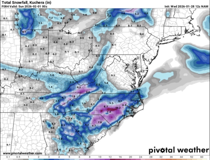
-
The “I bring the mojo” Jan 30-Feb 1 potential winter storm
Snowncanes replied to lilj4425's topic in Southeastern States
Hr 72 is a good bit more east on the 5H and slower to cutoff and go neutral/neg. Not sure how this impacts the downstream yet -
The “I bring the mojo” Jan 30-Feb 1 potential winter storm
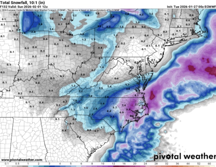
Snowncanes replied to lilj4425's topic in Southeastern States
10:1 euro map
-
The “I bring the mojo” Jan 30-Feb 1 potential winter storm
Snowncanes replied to lilj4425's topic in Southeastern States
precip shield looks weird on this run. Would imagine it fills in as we get to hour90. H5 looks decent, not as good as gfs but still trending well for us I think. -
The “I bring the mojo” Jan 30-Feb 1 potential winter storm
Snowncanes replied to lilj4425's topic in Southeastern States
It’s quiet… euro running. AI out to 36 looks the same -
The “I bring the mojo” Jan 30-Feb 1 potential winter storm
Snowncanes replied to lilj4425's topic in Southeastern States
Canadian. Hopefully this appeases the NW trend worriers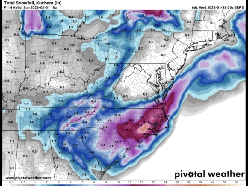
-
The “I bring the mojo” Jan 30-Feb 1 potential winter storm
Snowncanes replied to lilj4425's topic in Southeastern States
Canadian weenie run inbound. H5 almost the same as the gfs. A little south. -
The “I bring the mojo” Jan 30-Feb 1 potential winter storm
Snowncanes replied to lilj4425's topic in Southeastern States
Another run for the weenies. H5 cutoff low exactly the same spot at 18z Sunday. -
The “I bring the mojo” Jan 30-Feb 1 potential winter storm
Snowncanes replied to lilj4425's topic in Southeastern States
Well I guess his forecast is changing drastically now then lol -
The “I bring the mojo” Jan 30-Feb 1 potential winter storm
Snowncanes replied to lilj4425's topic in Southeastern States
Man the GFS has actually been the most consistent the last day and a half. Trying not to let it suck me in lol -
The “I bring the mojo” Jan 30-Feb 1 potential winter storm
Snowncanes replied to lilj4425's topic in Southeastern States
Whiff again at the surface. Need a little less interaction with the 50/50 low in order for it to close off I think. Trended west early on, Didnt close off. Pick your poison -
The “I bring the mojo” Jan 30-Feb 1 potential winter storm
Snowncanes replied to lilj4425's topic in Southeastern States
ICON a little stronger and more west with the northern stream energy at hr84-90 but doesn’t look like it closes off as early -
The “I bring the mojo” Jan 30-Feb 1 potential winter storm
Snowncanes replied to lilj4425's topic in Southeastern States
KEY MESSAGE 2: Confidence is increasing in the potential for a coastal low to bring a period of snow and bitter cold to central NC sometime between Friday night and Sunday, though details on timing, amounts, and impacts remain uncertain. Medium-range guidance and ensembles continue to signal the development of a very favorable synoptic pattern for a coastal low developing late this week into the weekend. A mid/upper level trough will dive southward across the Mississippi and Tennessee Valleys before cutting off just west of the Appalachian mountains. This would support a surface low developing along the Gulf shore, then sweeping across northern Florida, and deepen off the Carolina coast on Saturday bringing precipitation to Central NC. Recent model trends favor a slightly farther west track of the upper low and surface cyclone, which has increased chances for snow inland across central NC. With the Arctic air mass already in place, and forecast soundings showing no warm nose aloft, precipitation would fall primarily as snow, with no sleet or freezing rain mixing in at this time. As the upper low moves across the region Saturday into Sunday northerly flow should help keep the cold air across central NC through the weekend during the precipitation. While this Miller-A storm setup is one of the more favorable for snowfall across the area, significant accumulations are not guaranteed. Snowfall amounts will depend heavily on the location, timing, and interaction of the northern and southern stream flow. Another major factor in play is the location and proximity of the coastal low offshore. At this time, confidence is highest for frigid temperatures over the weekend mixed with a chance of wintry precipitation as early as Friday night through Sunday morning. However, it is too early to pinpoint where the heavier snowfall will fall and where the narrow deformation band would be most likely. RAH seems fairly bullish -
The “I bring the mojo” Jan 30-Feb 1 potential winter storm
Snowncanes replied to lilj4425's topic in Southeastern States
500 level trended slightly better. A little more southwest. Just not quite soon enough for a full bomb, but it’s close.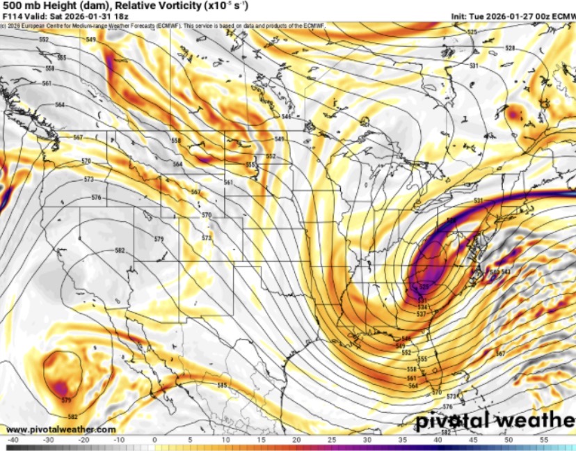
-
The “I bring the mojo” Jan 30-Feb 1 potential winter storm
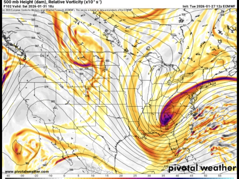
Snowncanes replied to lilj4425's topic in Southeastern States
6z euro AI looks a few ticks better at 5H. Goes neutral a little earlier and negative a little further SW -
The “I bring the mojo” Jan 30-Feb 1 potential winter storm
Snowncanes replied to lilj4425's topic in Southeastern States
I don’t have the kuchera but here’s 10:1