Snowncanes
-
Posts
169 -
Joined
-
Last visited
Content Type
Profiles
Blogs
Forums
American Weather
Media Demo
Store
Gallery
Everything posted by Snowncanes
-
The “I bring the mojo” Jan 30-Feb 1 potential winter storm
Snowncanes replied to lilj4425's topic in Southeastern States
Euro OP is a little east on H5 starting about 72 hours. A little too far east and positive tilt to really bomb it out but not too far off. Still time. Honestly makes me feel better not everything has us in the bullseye at this point lol -
The “I bring the mojo” Jan 30-Feb 1 potential winter storm
Snowncanes replied to lilj4425's topic in Southeastern States
Not bad, just not the Canadian lol. Also this is 10:1 so up those totals a bit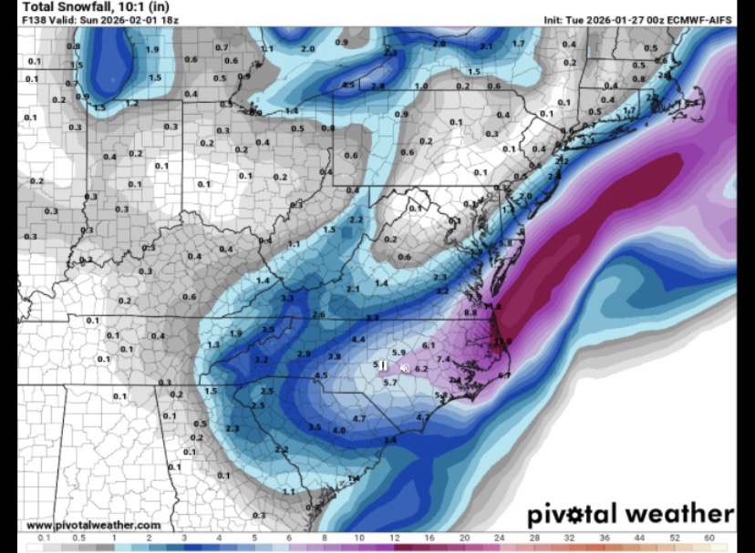
-
The “I bring the mojo” Jan 30-Feb 1 potential winter storm
Snowncanes replied to lilj4425's topic in Southeastern States
Going neutral at 114 and looks similar to canadian -
The “I bring the mojo” Jan 30-Feb 1 potential winter storm
Snowncanes replied to lilj4425's topic in Southeastern States
-
The “I bring the mojo” Jan 30-Feb 1 potential winter storm
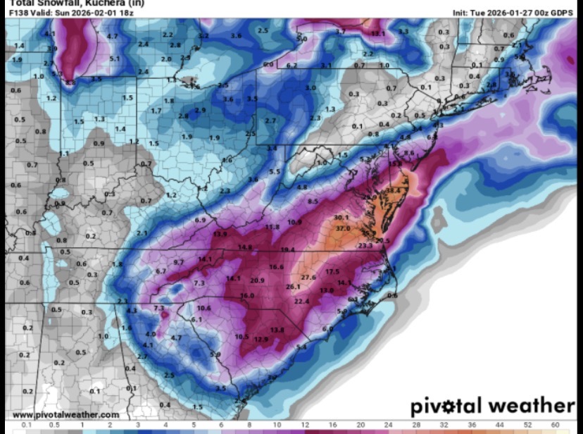
Snowncanes replied to lilj4425's topic in Southeastern States
This is 6hr Kuchera. 14.5” for RDU in *6* hours.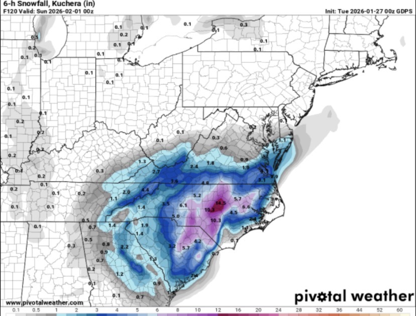
-
The “I bring the mojo” Jan 30-Feb 1 potential winter storm
Snowncanes replied to lilj4425's topic in Southeastern States
Closes off and goes neutral at hr 117 just slightly west of where it did earlier. Like maybe 30 miles lol. Trend is looking good though. -
The “I bring the mojo” Jan 30-Feb 1 potential winter storm
Snowncanes replied to lilj4425's topic in Southeastern States
Icon trended west with the northern stream but Didnt phase and cut off and slid OTS. Kinda weird look at 500mb though. I thought it looked good about hour 50 and then just Didnt phase. -
The “I bring the mojo” Jan 30-Feb 1 potential winter storm
Snowncanes replied to lilj4425's topic in Southeastern States
For ease of comparison sake -
The “I bring the mojo” Jan 30-Feb 1 potential winter storm
Snowncanes replied to lilj4425's topic in Southeastern States
I’d say most models are spitting out about 15-1 ratios over most of central NC it seems based on comparing QPF to snowfall maps. -
The “I bring the mojo” Jan 30-Feb 1 potential winter storm
Snowncanes replied to lilj4425's topic in Southeastern States
True, I guess I hadn’t seen how bad the 12z run was haha. Definitely trended better for us -
The “I bring the mojo” Jan 30-Feb 1 potential winter storm
Snowncanes replied to lilj4425's topic in Southeastern States
AIGFS way south with the low. Doesn’t phase early enough and slides south. Still a little QPF but mostly light stuff from the northern stream energy. -
The “I bring the mojo” Jan 30-Feb 1 potential winter storm
Snowncanes replied to lilj4425's topic in Southeastern States
UK a later phase and we get an inch or two out of the northern stream energy but the rest slides off the coast -
The “I bring the mojo” Jan 30-Feb 1 potential winter storm
Snowncanes replied to lilj4425's topic in Southeastern States
CMC a big hit for basically all of NC/SC -
The “I bring the mojo” Jan 30-Feb 1 potential winter storm
Snowncanes replied to lilj4425's topic in Southeastern States
Look at these ratios… 15” for Raleigh with .8 qpf.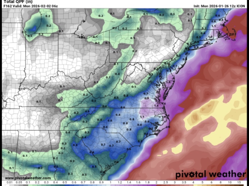
-
Check the obs thread, plenty in there
-
Southern Crippler - Get well soon Jimbo Storm Obs
Snowncanes replied to BooneWX's topic in Southeastern States
Light mist/drizzle in Cary. No real radar returns overhead either -
Southern Crippler - Get well soon Jimbo Storm Obs
Snowncanes replied to BooneWX's topic in Southeastern States
-IP/ZR mix here in downtown Cary. 21/4 -
Southern Crippler - Get well soon Jimbo Storm Obs
Snowncanes replied to BooneWX's topic in Southeastern States
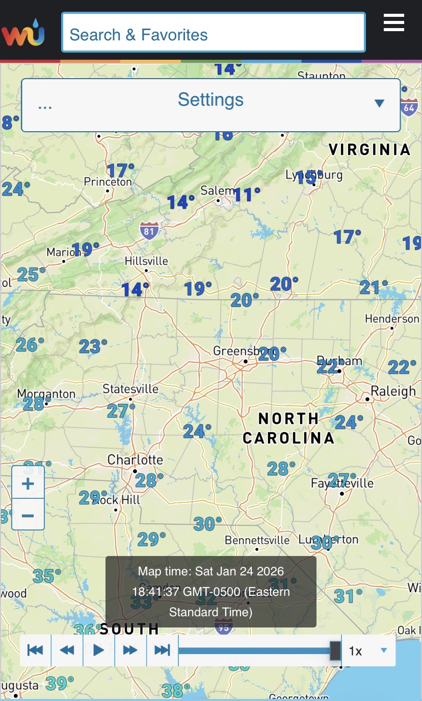
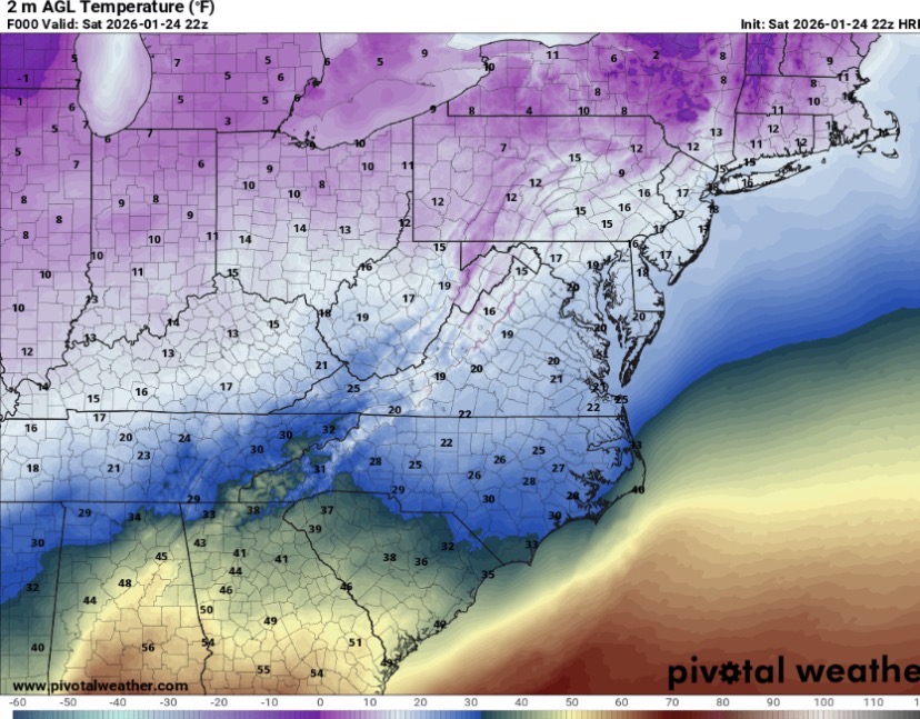
On mobile so sorry for the zoomed in on central NC view, but temps in the piedmont are generally running 2-3 degrees below both HRRR and NAM3k.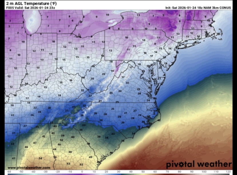
-
Southern Crippler - Get well soon Jimbo Storm Obs
Snowncanes replied to BooneWX's topic in Southeastern States
Sleet in downtown Cary. 24/4 -
Just another observation: lots of reports of precip with not much in the way of radar returns. Just a reminder that with a wedge airmass (especially a shallow one) we can get light precip thats not necessarily showing up on radar. In turn that means models dont resolve this well.
-
Southern Crippler - Get well soon Jimbo Storm Obs
Snowncanes replied to BooneWX's topic in Southeastern States
Moistening the column a bit though. -
Brad P says he’s not buying the scattered nature of precip showing up on the models. Doesn’t think they’re handling the cad/lift well. Even if precip isn’t showing up on radar, we all know how cad days are always misty/drizzle. I don’t think we are missing out on this in the cad favored regions.
-
Southern Crippler - Get well soon Jimbo Storm Obs
Snowncanes replied to BooneWX's topic in Southeastern States
24/4 here in downtown Cary -
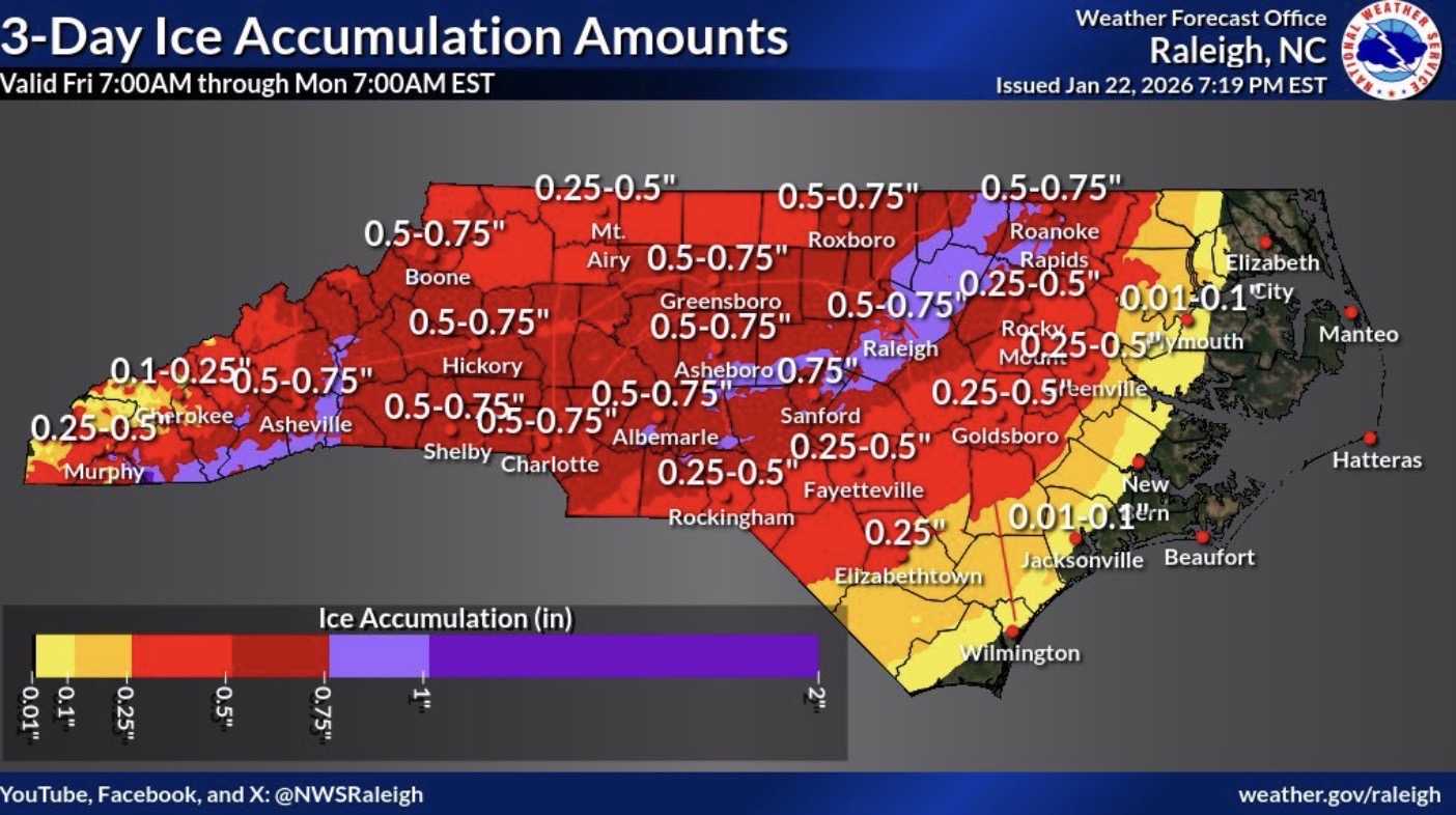
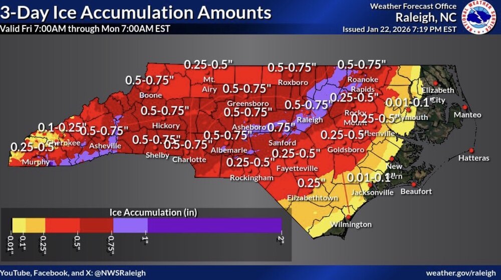
Wow… NWS is bullish on the ice. Not good
-
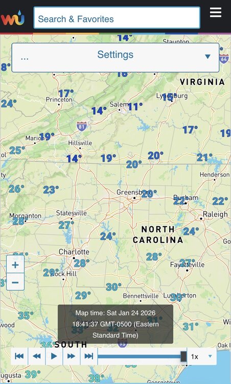
GFS has most of NC 35 or below for the foreseeable future. Could mean anything that falls sticks around for a bit.