

winter_warlock
-
Posts
1,110 -
Joined
-
Last visited
Content Type
Profiles
Blogs
Forums
American Weather
Media Demo
Store
Gallery
Posts posted by winter_warlock
-
-
1 minute ago, Heisy said:
Icon destroys us. Couldn’t ask for a better start to the first 12z runs of 2024

.Need that a lil farther east
-
 3
3
-
-
2 hours ago, NorthArlington101 said:
Better map
Wow. If that happened id shit my drawers!!!
-
Anyone got the ukie???
-
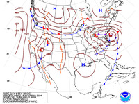
Very latest from Wpc ...
-
2
-
-
1 minute ago, Scraff said:
Best GFS run of 2023! Let’s hope 2024 has more of the same.
")
Amen brother!!!
-
3
-
-
If models continue to look like this . Alot of us gonna have sleepless nights waiting up for euro every night ! Lol
-
 1
1
-
 3
3
-
-
Just now, jayyy said:
GFS / GEM both showing significant snows for 90+% of us?! Forgot what that felt like. Too bad this storm is 7 days out. Expectations will be mighty high from here on out for the usual suspects.
.Probably the best shot at something significant for alot of us in a couple years!!
-
1 minute ago, jayyy said:
Woof. Obviously ignoring the snow maps, that was a nice run there.Yessir!!!!!
-
Well after seeing the gfs and cmc. I think were all gonna be waiting for the euro!!!
-
1
-
1
-
-
Just now, NorthArlington101 said:
zoomed in

Lock it in!!!
-
1
-
1
-
-
Just now, stormtracker said:
So, checking things before I head out partying...I'd say GFS looks a little better. But I'm buzzing so....
Enjoy ur self bro drink a few for me!!!
-
1
-
-
1 minute ago, Ralph Wiggum said:
GFS is souther. Eta: much better confluence....colder.
Liking the way that sounds!!!
-
Latest disco from sterling!!!! Good read....
As we move into the weekend, attention will turn to a storm system
approaching from the south and west. By Friday night, this system
will be located over the southern Plains. The initially closed upper
low is modeled to transition into more of an open wave and
potentially take on a negative tilt as it tracks east-northeastward
toward our area. With the system taking on a negative tilt, there
could be a corresponding strong area of low pressure at the surface,
with access to ample moisture from the Gulf of Mexico. As one would
expect seven days out, there is still considerable spread with
respect to the track of this system, but most solutions cluster
somewhere between a track into the eastern Ohio Valley and along the
coast just off to our south and east. Probabilities for substantial
QPF continue to increase. If the storm were to take a favorable
track off to our south and east, some or all of this could occur as
snow across portions of the area. Synoptically speaking, most
solutions don`t have a strong area of high pressure off to the
northeast, which could work against a snow solution, but the airmass
in place ahead of the system is fairly cold/dry, which could create
a decent amount of cold air in-situ once precipitated into. We`ll
continue to monitor this system over the upcoming week, as it has
the potential to be the first substantial winter storm of the season
(and really last two seasons) to the east of the mountains
-
1
-
-
14 minutes ago, Eskimo Joe said:
It's all confluence. Look at the placement of the high on the 18z GFS. Stronger and further west. It's much better.
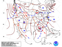
Latest update from WPC. I like where they have the low!
.thumb.gif.fd9bbb4000934c913b3efaa34407cf00.gif)
-
2
-
-
7 minutes ago, osfan24 said:
Doesn't matter at this point, but a 986 there isn't likely to die out quickly.
986!! Hmm looking like a cutter to me......
-
2
-
-
15 minutes ago, TSSN+ said:
Most members decently se of op.

Now that looks much better than the gfs OP!! Will prevent cliff jumping lol
-
1
-
-
3 minutes ago, psuhoffman said:
Technically the day 5 and 7 scores say it’s Euro, UKMET, CMC, GFS. Anecdotally the uk seems to struggle with east coast storms though. Doesn’t mean it’s wrong now though.
Ahhh. Ok ty bro! Ill take modeling this far out with a grain of salt!
-
2 minutes ago, brooklynwx99 said:
UKMET is the second highest scoring model. the GFS is the worst major model lmao still
Nicee then lock it in !! Lol
-
2 minutes ago, DarkSharkWX said:
verification scores are 2nd just behind euro
ahead of cmc and gfsOh. Ok nice
-
Well gfs was nw... cmc Was a lil bit south east of gfs .....And ukmet was south and colder.... cant wait to see what the 12z euro has !! Lol
-
2
-
-
Just now, DarkSharkWX said:
ukmet looks good, cold and south
less amped than 0zHmm how accurate is the ukmet compared to gfs a week out ?? Lol
-
Well im in baltimore county MD so... With these storms its always a wait and see thing till its right on top of us lol
-
1
-
-
One saving grace is its 7 days out! So alot can and will change in next 168 hours! Lol. Im mean come on folks do any if us really wanna be in the bulls eye 7 days out?? Lol
-
1 minute ago, Heisy said:
12z gfs will be amped, 50/50 backing off a bit and main wave is even stronger, congrats buffalo this run
.Not good for mid Atlantic
.gif.287ec5a2652cca35f35629e787fdf902.gif)
Jan Medium/Long Range Disco: Winter is coming
in Mid Atlantic
Posted
Wow nice!!