

winter_warlock
-
Posts
2,265 -
Joined
-
Last visited
Content Type
Profiles
Blogs
Forums
American Weather
Media Demo
Store
Gallery
Posts posted by winter_warlock
-
-
Just now, Sernest14 said:
That’s not how it works
Well being 120 Mile's south would make ya a lil warmer
-
Well at least the models can all agree we won't have temps in the mid 90s next week

-
3 minutes ago, Heisy said:
Isn’t this height pattern on some of your guys profile pictures?

.Wow!!! If it wasn't 2 weeks out I'd have more faith in it happening lol
-
 1
1
-
 1
1
-
-
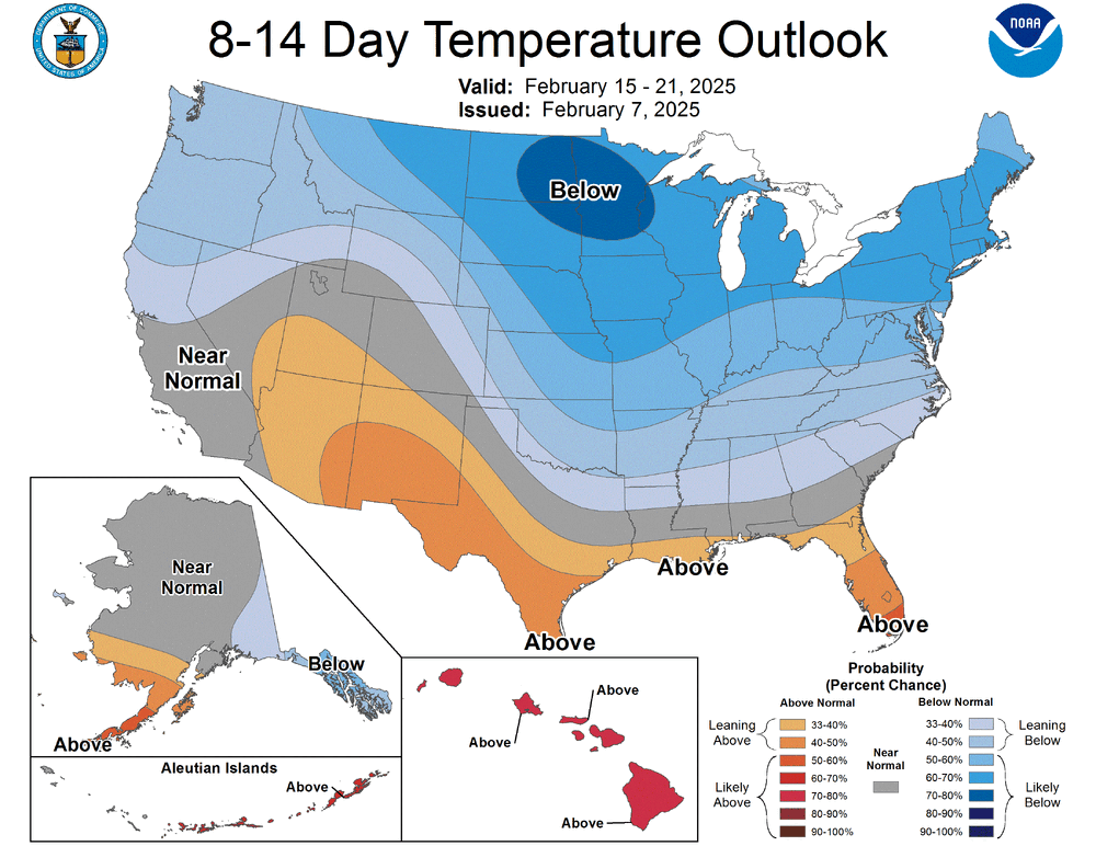
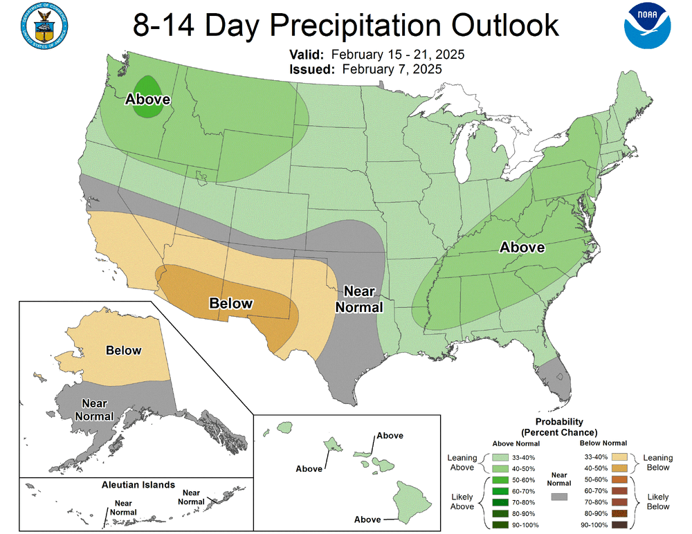
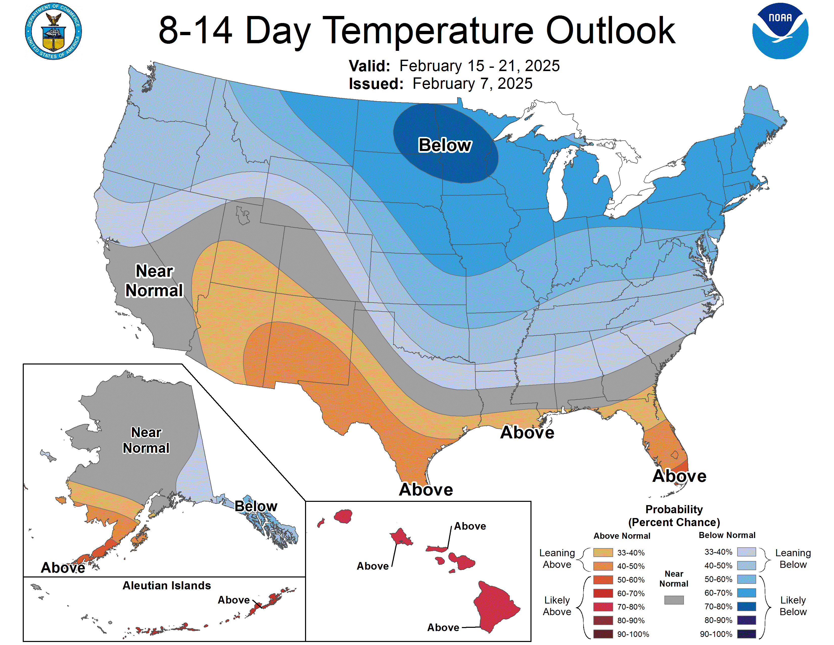
Latest 8 to 14 day outlook shows below normal temps and above normal precip. That could be nice for us!!!
-
1
-
 1
1
-
-
Just now, CAPE said:
I never said the ensembles looked amazing for next weekend, but there is some uncertainly for that period wrt the overall evolution and storm track.
Ok ill give ya that bro!!
-
1 minute ago, aldie 22 said:
Is now the time we all start talking about when we joined Eastern?
Why?
-
Just now, CAPE said:
Don't sleep on late next weekend/PD. Probably not PD III but I have kind of liked that period. Some ens members on the 12z run were pretty interesting.
Yeah well ensembles looked amazing for us for Tuesdays storm 3 days ago lol but that changed lol
-
3
-
1
-
-
5 minutes ago, Sernest14 said:
Modeled temps from both gfs and euro are in the low to mid 30s…
Doesn't mean that are right lol I'm in north central md and have temps modeled in the mid 30s lol hard to beleive theyed have same temps 120 miles south
-
 1
1
-
 1
1
-
 1
1
-
-
It's obvious that. We're still 100hours out and models have no idea wtf is going on lol
-
1
-
-
My sister lives in Richmond .. she Said news said NWS is saying not much in the way of snow. Maybe mix. Temps could be in 40s. So I thi k snow maps are way over done lol I even checked the Richmond noaa site and it does say. Mix with temps to low 40s so snow maps over done lol
-
1
-
-
11 minutes ago, WesternFringe said:
It was a typo, my bad. Meant 93 hours. My apologies, FOLKS. I should no better.
Lmaoo it's all good bro we just ribbing ya
")
-
1
-
-
2 minutes ago, hstorm said:
Tough crowd. @WesternFringe made an obvious typo . . . should have been 93 hours not 43. That's "less than 4 days out."
Oh ok well I hope it was a typo..... or he needs to improve his math skills
") lol. J/k!
lol. J/k!
-
1
-
-
Just now, stormtracker said:

-
8 minutes ago, WesternFringe said:
Per the GFS, snow arrives in the DC metro area in about 43 hours, so less than 4 days out.
Dude it will not be in DC by Sunday afternoon. Wtf are u looking at??
-
22 minutes ago, NorthArlington101 said:
this is most of it
Wow niceee!! Glad I got my pamper on today!!!! Lmaooooo!!
-
 1
1
-
-
4 minutes ago, midatlanticweather said:
Rather have it south than north for bullseye at this point
Agreed!!!!
-
3 minutes ago, hstorm said:
I, for one, wouldn't be complaining about this.

That's 2 storms lol so north of Richmond... thats not alot for 2 events. But 204 hours out..it won't even look like that in a week lol
-
Just now, ravensrule said:
@winter_warlockreally screwed the forum when he shitted himself.
Lmaooooooo
-
Just now, clskinsfan said:
The GFS is a fucking weenie run. Any other take is ridiculous. A week of waves are coming. Maybe we win a bunch of them. Or maybe we dont. The next 2 weeks are going to be insane yall
Weenie run for some....
-
5 minutes ago, wasnow215 said:
And RVA!!
Don't get cocky lol it may move back north in 6 hours lol
-
1
-
-
To the people who are less then thrilled about the drop south.... its still 100+ hours. If I remember correctly. The jan 6th snowstorm didn't get nailed down by models till almost 48 hours before the event. Still 25 model runs( icon, gfs,euro,euro ai) and 12 model runs( cmc,ukmet) to go so beleive me this this gonna change at least a few more times! So plz back off the edge of the cliff lol
-
2 minutes ago, stormtracker said:
We're more than fine. The GFS is gonna wobble. But the RIC folks are happy with this run
Be curious to see if the GEFS ensembles also went south
-
1 minute ago, stormtracker said:
We're more than fine. The GFS is gonna wobble. But the RIC folks are happy with this run
Be curious to see if the GEFS ensembles also went south
-
Just now, NorthArlington101 said:
Some would say right where we want it. Acceptable at range
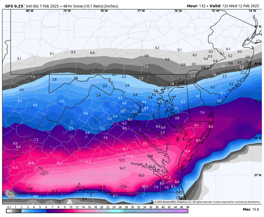
Thats a shift of nearly 100 miles lol just another solution onto cmc and euro


February Medium/Long Range Thread
in Mid Atlantic
Posted
If temps stay low enogh