

psuhoffman
-
Posts
27,420 -
Joined
-
Last visited
Content Type
Profiles
Blogs
Forums
American Weather
Media Demo
Store
Gallery
Everything posted by psuhoffman
-
I think the coop they used there is right on the bay so it skews low.
-
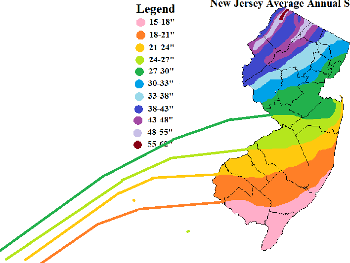
@RevWarReenactor they might not have "lied" to you, simply fallen to a common misconception. West can help wrt snowfall...but only if you get far enough west to enter another climate zone. The reason west helps is because of the contour of the elevation zones in the mid atlantic. If you go far enough west you get out of the coastal plain and into the Piedmont. Go far enough west and you get out of the Piedmont and into the mountains. With each elevation increase you enter a better climate zone for snowfall. But within each zone...north/south matters more than east/west. You can see that with these snowfall maps here...I continued the approximate contours from the NJ map to help show how once you hit the fall line...snowfall totals turn southwest due to the climate zone change...but within the coastal plain the contours run more west to east. You can see on the Maryland snowfall map how there is a tight gradient along the fall line. Had you moved 15 miles further northwest THEN you would have seen a dramatic change in your snowfall. But moving east and west within the coastal plain won't make much difference. Within each climate zone local meso scale terrain features like ridges and water matter more. So being right along the immediate coast...like on the barrier islands...will get less snow than 10 miles inland. But once inland a little snowfall won't usually change much going another 10 miles east or west. Someone right along the Delaware river will get less snow than someone 250 feet higher up in South Jersey for instance. Look at where you are on that MD map...you had the misfortune of moving into a local snowfall minimum also...a region that is between the Chesapeake bay and Delaware river...at very low elevation. Warmth floods up the bay and river.... you have a downsloping wind from every direction...and a wind off water from many directions. You are in a bad local area also. When I moved from southern NJ to northern VA I did see an increase in snow...but only because I went from the coastal plain to the Piedmont. Had I moved somewhere 15 miles further southeast in VA I would have actually gotten less snow than where I used to live southeast of Philly. Elevation is the reason going west helps...but if you go west and do NOT increase your elevation...you really aren't doing yourself any good. And if you go west and put yourself into a local snow hole due to terrain features you can even get less. I get way more snow than places west of me in the valley there. Hope this helps explain the real phenomenon you are describing.
-
First of all I hope you don't find this antagonistic. I don't find any of this to be hostile. We have different opinions but it's an interesting conversation that is all. It has been a crappy run for snow. I am not happy with the results either. But I am taking a purely statistics and probabilities side here. In the last 10 years DCA had 4 years above average. That still holds with the long term "normal" frequency. Those years can sometimes come in chunks with long periods in between...that has always been the case. There is a very random distribution to our big snowfall years. You have to look at the frequency over longer periods of time when you have that kind of distribution to see real trends versus just random noise. Like a coin flip. You can get 5 heads in a row...and think that is a trend...but if you step back and look over 20 or 30 flips you are more likely to see it even out towards the 50/50 probability. Over the long term the odds of a big snowfall year is about 30% and we will have runs of good or bad within but over the longer term it usually ends up evening out to about that 30% chance. I am not trying to say its been a good run for snow. Its been crappy. But the problem is we live somewhere that crappy is kind of the normal base state most of the time. I am just accepting that reality. Not saying you should be happy about it. WRT your take on different years...and how snow comes. Again you feel how you feel...no changing that, but what you describe...late snowfalls (or even mid winter ones) that melt right away...or turn to rain and get washed away...or imperfect storms that dry slot us...that describes A LOT of our snow. If you start to toss years that got to a decent result but did it with "flawed" storms you end up making our already crappy climo even worse. For instance if you remove the "good snow years" in DC where most of that snow came from one big storm OR most of that snow came late in the season then you end up tossing "good years" like 1960, 1972, 1983, 2000, 2015, 2016, 2019... take those away and now your probabilities of a "good year" go down to like 20% if not worse. On top of that a lot of the "mediocre" years become awful if you toss one big storm years...like 2006, or years where most of the snow came from flawed melty storms or late season storms....like 2018. Do that and now the chances of a total crap season goes up even more. So I get why you don't "like" those storms as much...I just don't think you get how rare what you "want" really is. How common has it been for us to get a winter where we get a lot of snow from multiple "cold" storms? How many of those have happened in the last 30 years? 1996, 2003, 2010, 2014, 2015... is that it? Am I missing any? If not that is 5 times in 30 years... that's only 17% of the time. You only have a 17% chance of getting that in any given year. I am not saying that isn't what you should want...and I want that too...I just realize how rare that is around here. I also think you are mis remembering some years. 2002 DC only had 3.2". It was 2003 that was great and that was a nino year. 2004 was only 12.5" so it was decent but not a "good" year, especially by your standards. 2006 DC had 13.6" and most of it came from one storm that was a meltathon right after so doesn't that fall into the type of years you say you don't like? 2008 was only 4.9 all of it came from a clipper in early Dec and then two 1" slush storms. I highly doubt you really thought that was "decent" at the time. 2009 was 7.5" almost all from one storm in March that melted the next day. So.... You are saying some of those werent that bad but they were every bit as bad as some of the years in the last 10 that you complained constantly that they sucked as they were happening. They were all way worse than 2018 was in your location and you hated that year when it was actually happening. I think time has a tendency to edit our memories. 15 years from now maybe all I will remember from this winter is that one good snowstorm I got in January and the day in the snow with my children and it won't seem as bad. But the numbers don't lie.
-
Nino winters using January for the year 2003,2005,2007,2010,2015,2016,2019 nina years 2001,2006,2008,2009,2011,2012,2017,2018 neutral years 2002,2004,2013,2014,2020 Let me explain my rationale. This year has been awful. It’s not normal. But it is normal to get a year like this every 8 years or so. This one ended up even worse then some similar comp years with a similar pattern like 1989, 2002, 2008 but only slightly because each of those years lucked into one storm and this year didn’t. But it ended up similar to some other years like 98, 73 or 52 that also ended up pretty snowless. But these type years have been trending worse for a while. 2017 was another example where similar comp pattern years in the past might have produced 8” but recently that’s been trending down so the 3” result wasn’t shocking to me. That this year ended up with almost nothing vs the 3-4” it might have produced in a similar year 30 years ago also doesn’t shock me. That just seems to be the new normal now. But that doesn’t bother me that much because honestly would you feel better if we had eeked our way to 5” from a couple minor slush events? You know not, you complained non stop in years like that also. So who cares if our awful years are 3” instead of 5” or 1” instead of 3” now. The frequency of our “good winters” actually hasn’t changed and is still about 30%. Those are the only years you and most would be happy with the results anyways. The other 70% is some variation of suck that are mostly warm with little snow and most of that snow is flawed minor events that you toss and those years won’t make you happy whether the final total is 2” or 5” or 8”. So im not obsessing over the fact that in our typical run of 4 crap years we get every decade we end up with 27” total instead of the 32” we might have gotten 20 years ago. That seems to be the expected result of the recent trends. Im not saying this is normal. I’m saying there is no normal but that this run doesn’t fall outside of an expected result to balance out the run of luck we had earlier in the decade. I never hear you complaining about how not normal it is when we get a lot of snow.
-
Too much bitter for some
-
As @C.A.P.E. said there is no "normal" for us. Statistically normal is usually anything within a standard deviation. I don't remember exactly what it came out too but I ran the numbers once and one standard deviation wrt snowfall here is useless. Because our snowfall year to year is so varied it was something like anything between 1 and 40". We have no "normal" snowfall distribution...we don't live somewhere that has a typical expected snowfall each year. We can get 1" and 40" with about equal probabilities...and everything in between. WRT this current 4 year run...look if it makes you feel better to cling to the idea that it isnt normal and is the worst spit in our eye of mother nature fine. I have no idea what that would make you feel any better. But if you keep expecting things to be better than recent history and trends suggest its likely to be year to year...you are just going to keep being frustrated and disappointed most years. I have no idea if this is a more temporary climate cycle (some of it probably is wrt NAO) or a more permanent shift due to warming (some of it likely is) but the bottom line is there has been an observable change. Nino years havent changed much. We still average about 25" in a nino since 2000. That was about the same before that. Our chances of an above avg snow year are still good in a nino. But since 2000 EVERYTHING else has been crap. We have only had one good snowfall year since 2000 in a non nino year. The other 12 were all some variation of garbage. That didn't used to be the case. Enso neutral years used to produce above avg snowfall years much more frequently in the past. Not so anymore. On top of that years with a crappy pattern are trending downwards in snowfall results likely due to warming eliminating some of the marginal fluke snowfalls that would get a year like 1989 or 1992 or 2002 to 5" instead of 1" or nothing. When you combine those FACTS it makes what is happening now totally expected and inevitable. I don't know if this trend will continue but until it changes we should expect similar results. Some good years surrounded by long stretches of really really bad is the new normal. It's been that way and trending worse for over 20 years now. For some reason you seem to want to set your expectations based on how things USED TO BE 50 years ago instead of what the evidence suggests is a reasonable expectation in our current climate cycle.
-
You could make it harder to attack you if you didn’t post absurd nonsense. You recently criticized us for not using analogs when the long range and seasonal thread is filled with analog discussions. I made a post months ago showing the analogs to this year and how awful they were. And many others said similar. Just because you didn’t read it...which is fine but then to criticize a thread you obviously don’t bother to actually read makes you look bad. You make rants about NWP (like it hadn’t improved in the last 20 years) that are easily disproven as false. You make up crazy conspiracy theories that insult the integrity of some of our best professionals in here who would have to be part of that conspiracy, ignoring the insult to logic that is your theory. Then you start this thread acting like there was and is no way to know what went wrong when we have been discussing that for weeks now and this exact type season has happened before and we do and have known “what went wrong”. Sorry but you make yourself an easy target.
-
@C.A.P.E. Tenman and this thread is absurd Weve known for months this winter was a turd numerous posters said without a lot of luck how bad this season was going to suck he complains we don’t use analogs obviously he didn’t read the long range blogs a central pac ridge +AO is crap once that set in we knew it was a wrap but he is still trying to figure what went wrong Long after the rest of us moved on but I’m sure he won’t listen to me And blame it on a government conspiracy.
-
There was a man in Delaware who loved snow I told him dude you got to go Somewhere up north I would find henceforth For the sake of your sanity oh and lay off the Hannity The population density might be crappier but you will be much happier In a place where the nao isnt needed to get snow so for the love of god GO
-
But you are ignoring climate change. If you look at the trends it is normal now. Go back and look at the patterns the last 100 years. The good years aren’t changing wrt frequency or totals but the bad years are getting worse. 50 years ago a bad year was 10”. Now most bad years struggle to get to 5 or 7” and the frequency of below 5” winters is going up. Since 2000 (not including this year yet) we have had 13 non nino years. In those years 12/13 were below avg and the median snowfall is 7.5”. Furthermore 5 were below 5”. The new normal for non nino years is for most to be pretty awful. Because that is a new phenomenon that is getting worse everytime we get a bad run (which are common even in the old climate to get 3-5 year bad periods only now the bad years are worse) we will likely challenge the “worst period ever” thing you are clinging too. But is it “not normal” when it’s been happening and trending this way for 20+ years now?
-
I can think of something else that describes
-
I must look into this analog thing. Never heard of it. Sounds like voodoo black magic to me.
-
Unfavorable pac forcing combined with a strong PV. Years where there was a significant pattern flip from warm to cold during winter 1958,1960,1966,1972,1987,1993,1999,2000,2005,2007,2014,2016,2018. There are plenty of flips from cold to warm also. But by New Years the combo of a strong phase 5/6 mjo wave in conjunction with a strong PV coupling with the tpv hinted that this year was at risk to be a total dud. That combo is the leading cause of our total wasted years. This result isn’t a big surprise.
-
Thank you. 2 thoughts wrt what you noticed (I noted it also). First it's hard to draw conclusions about that because what those numbers don't show is the frequency of those patterns. If a pattern is more rare it might be the best pattern but have less instances of snow simply because there were less opportunities compared to a more common but less productive pattern. That said, I do think there is also a bit of "too much of a good thing" going on with a -EPO/+PNA full latitude ridge. In a vacuum a -EPO/+PNA/-AO/-NAO are the best phases of each of the 4 major indexes. But when in combination it's not always that simple. When we have a really strong -NAO for instance, some of our biggest snowstorms happened with an unfavorable PNA/EPO combo, but in reality that "unfavorable" pattern out west trying to force ridging into the cold locked into the northeast is what created the big storm. Without that we would have been cold/dry with a weak wave running off the southeast coast. Time of year also matters...we typically need the epo/pna more early in the season and the nao more late. Without any NAO help...by far our best look is that east based EPO ridge nosing over the top creating a broad flat trough under it across the lower 48. The NAO changes the equation. The more blocking (especially later in winter) the less we need EPO/PNA help. Enough blocking later in the season and we actually dont want a big wester ridge. So there really is no one perfect look that is universal across the whole winter season. That study I did was just step one is a larger plan. Right now I have no time for anything. My less frequent posting lately is not just because the weather sucks... its more that this is a busy time of year for me. December/January I have a lot of free time. Between Holidays, end of semester and PD breaks there, and testing I have a solid 2 months with not much going on other than my normal teaching duties and even those...I only have a normal class to plan for or stuff to grade about half the time. Right now is one of the times of year I am slammed with observations, curriculum planning meetings, summer school planning, bridge project scoring, Test prep planning, debate events... I just don't have time. But I have way more in the plans. I just found out I might be getting a rather significant increase in my responsibilities wrt to my summer position so I may not get to all of this but I should still have more time to at least start this list. In addition to what I did in December, I want to do a similar study for our area. Then I also want to look month by month and break down the dominant patterns from 1950 on to see the frequency of each pattern. I also want to break down those splits by month to confirm which patterns work best by each month. Once done I would be able to determine what the odds of snowfall in any given pattern are (roughly) by month. That would make what I posted here a lot more useful. But that will take a lot of time I don't have right now. If I don't get it finished this summer I probably will next December during my next "down time" period.
-
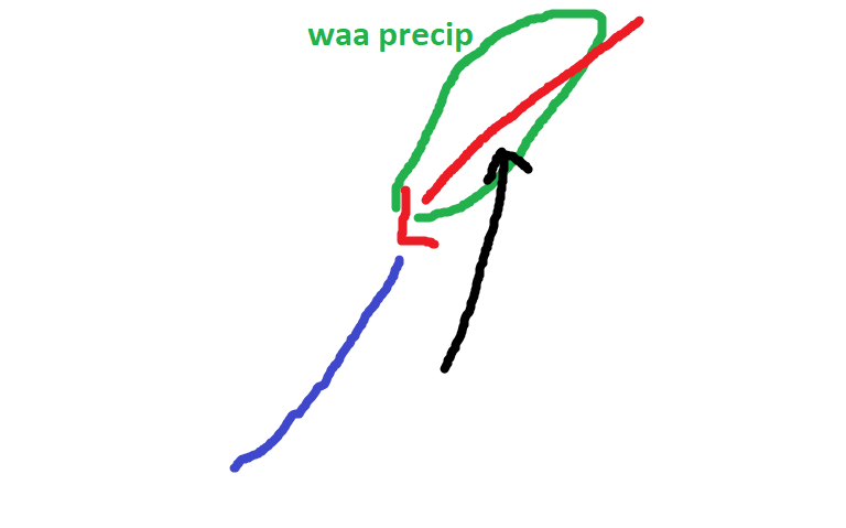
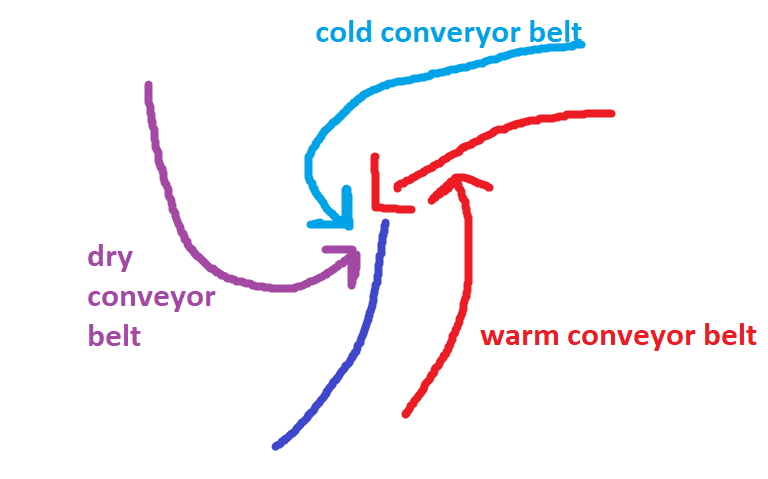
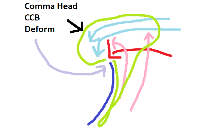
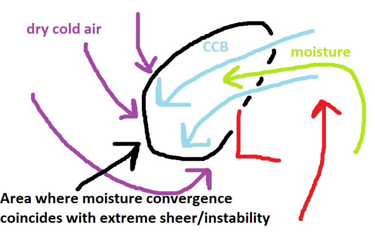
@Maestrobjwa CCB refers to the cold conveyor belt. I think to fully explain this I should do a quick overview of how most mid latitude cyclones work First of all low pressure typically forms along the boundary of cold and warm air...as air moves across the boundary to try to bring equilibrium to the imbalance. This movement of air creates lower pressure where the air is vacating faster than it is filling in. A low can really intensify when an area of divergence in the upper levels crosses over the surface area of lower pressure. These areas of divergence are typically found in front of either long-wave troughs or Rossby waves or smaller shortwave troughs embedded in the flow. This divergence aloft creates lift below it to "fill" the void and this lift (rising air) from the surface lowers the pressure as the lift outpaces the rate air is filling the surface void. On top of that the rising air cools and condenses causing precip but that process creates latent heat release which causes more lift (warm air rises). This creates a feedback loop that intensifies low pressure. Early in the life cycle of a developing low pressure area they are typically just waves along the temperature boundary Precipitation breaks out along the boundary where the flow ahead of the developing low pressure begins to cross the "boundary" to the north of the wave. The warmer air crossing the boundary has to rise over the denser colder air and this lift creates WAA (warm air advection) precipitation. (rising air cools and condenses creating precip) Showery precip usually exists along the cold front to the south of the low where cold air is undercutting the warmer air cause it to rise...but since this displacement happens much faster the precip there is sometimes more intense (thunderstorms or convective showers) but short lived. Many waves never make it beyond this stage if there are factors inhibiting their intensification. But if a low can amplify and deepen it will develop a circulation at several different levels As it develops this structure...the cold conveyor belt begins to bring moisture that is to the east of the low from the warm conveyor belt to the west of the low. As this happens the storm will begin to develop the classic comma head structure seen below. That precip to the west of the low track is often commonly called the "CCB" since it is a function of a healthy system developing precip in response to the cold conveyor belt transport of moisture west of the low track. Additionally the precip to the west of the surface low track is not driven by WAA as much as other forces and so can have a colder thermal profile, especially in marginal events. Seen above there the dry conveyor belt begins to cause the "dry slot" that you often get near the track of the surface low pressure. Below I have zoomed in on what is going on in the "CCB". This region in the "CCB" develops a deformation zone...a region where the atmosphere is being pulled in different directions at different levels. The convergence of the DCB, CCB, WCB, as well as the sheer at different levels created by the mid and upper level low pressures creates instability in this area. Where the moisture convergence from the CCB bringing moisture in off the WCB meets this instability you can get intense snow bands. This is what they call the "deform" band. One of the best examples of a deform band was from the February 2006 storm. This radar is from the NYC area but this same band impacted our area...I think the Columbia MD area got 20" because they were under this band for several hours. You can see on the radar loop the forces I described above at work. Later in the life cycle of a mid latitude cyclone, because the cold air often outpaces the advance of the warm air...the cold catches up and the low ends up cut off from the warm air advection...at this point we say it has occluded and it looks like this. At this stage the intensification period is over and the storm typically begins to weaken. But during this stage you can often see snowfall wrapped up even under the surface low instead of displaced to the NW of it. Hope this helped some. You can ask any follow up questions also...others feel free to add anything to this.
-
I know you’re busy...and I’ll be having some quality time with the wife...so maybe we should let Mersky take the wheel for the weekend. I fully expect to return to phase 8 bliss... blizzard warnings and talk of new biblical classifications.
-
The guidance mishandling of the play between the tpv and North Atlantic vortex really mucked things up. That phasing and consolidating into Baffin vs splitting and sliding out forces the canadien ridge too far south and flipped the pattern on a dime. It was one thing...but a BIG thing. Maybe one big thing will break in our favor one of these times.
-
It shifted quite a bit colder. But it seems to do that partially in response to bombing the day 10 storm then squashing everything behind it. Cold/dry day 11-16. But still a better look rolling forward than 12z was imo.
-
In fairness the gefs was better day 10-15 but dry. But closer to workable. It was a better trend fwiw.
-
Now that’s bad.
-
Wrt the mjo and pattern...that doesn’t mean things can’t flip...but that when we do see major pattern flips it’s not purely because of the Mjo. An example is 2017/18. We had a cold phase rotation earlier that didn’t do us much good but when it rotated into cold phases again later as the permanent NAM state was flipping it had the canonical response. But that pattern then went on to persist even as the mjo wave faded and went into warmer phases. We need an actual atmospheric base state change along with the mjo. An mjo wave temporarily traversing cold phases during an unfavorable global base state pattern won’t do much good imo. Those kinds of pattern flips can happen. But the most likely time is late. The Nina like pac response favors such. Think 1999, 2009, 2017, 2018. Not all do but many years with similar pac issues feature a legit pattern change for March. and before the “that’s too late” posts yes yes I know. I’m not saying I want that. Just saying that’s what might happen.
-
I’ve had a thought on the MJO for a while that I’ve mentioned a few times as to why we often don’t get the response we need when it goes into “cold phases”. The whole “MJO phase 8 is great...except when it goes into 8” thing. Basically I’ve theorized that the main reason the mjo phase 8/1/2 are correlated with the H5 look we want and cold is that those mjo phases are also correlated too and amplified by the types of global patterns that produce those results. So basically a winter here with a cold base state is likely to spend more time in cold mjo phases skewing those phases that way. But when we have a warm base state winter and we wait for an mjo wave to save us it rarely does. Even when it makes it into cold phases the response is muted. It often makes things “better but not good Enough”. I suspect a cold phase mjo is not as correlated to the response we want when it happens in warm base state winters. That is probably because it’s acting alone and not associated with the typical global pattern (canonical el nino) that it is during cold winters. Instead it’s being muted by the background warm base state. On the other hand I think the same is true in cold winters. Over the years when the mjo is about to crush our dreams and JB is spinning to save his subscriptions for another month he likes to throw out examples of warm phase rotations that were cold/snowy. But they are always years like 1978 where we were in a canonical nino pattern and the base state was cold. For the same reason in a year like that the warm mjo wave is muted by the background state. When we are in a warm year and the mjo spikes into warm phases we always torch. This has just been a theory and I never bothered to research and support it. I bring this up because isotherm seems to offer scientific support for this. Isotherm From the NYC sub “Chris, and I've been ruminating on some hypotheses re: the time-lag and distorted response. One issue, in my view, is base-state resonance. Sometimes the MJO/intraseasonal signal is misaligned with the base state, and as such, when it propagates through typically conducive phases, the N HEM response may not be bonafide/favorable due to the misalignment with the background indicators. For example, 2002-03 had a much more classic AAM/GWO and hadley/walker cell structures concordant with a canonical El Nino, and thus when MJOcirculated to 8, we had a more genuine N HEM response.”
-
Why are you stuck on the mjo projections. This started over you comparing my analysis of the EPS to Will’s and implying they have not gotten worse for our snow chances. Neither myself or CAPE said the EPS was right. Your off on a worthless tangent because your original point was BS.
-
Sorry let me clarify. The statistics for the pattern in January show we have a roughly 90% chance to end the year below normal snowfall based on past outcomes. That doesn’t mean it can’t snow at all. And hey maybe this is the 10% but right now that seems unlikely. Now below normal doesn’t mean no snow. But losing a huge chunk of prime climo to a crap pattern makes it hard to end well but we did have years like 2007 where a similar January went on to a snowier February. But the statistics were only about 50/50 about it getting any better the rest of winter. In some cases the pattern did shift but to another crappy one. I noted then that some of the crap years had a late snow in March and that might be our best chance. Wrt right now...the look day 15 can go either way. My lost earlier outlined that. But with the AK vortex there with a +NAO it will be hard to overcome. I was talking about day 10-15. I have no clue after. If the vortex shifts and an epo ridge pops like the guidance suggests then it’s a temporary problem. If it sets up shop there longer were in trouble. But I’m not going to speculate much past day 15. My guess is it’s temporary. But that still doesn’t mean we get a great pattern.
-
Again with the false equivalency. No one even said the EPS was right. I said it degraded the pattern for snow chances the last few runs. It did. I don’t know if it’s right. It’s 10-15 days away. That range is like reading tarot cards. But you’re using a bait and switch tactic to deflect from the fact your last claim was assanine.


