Nomz
-
Posts
639 -
Joined
-
Last visited
Content Type
Profiles
Blogs
Forums
American Weather
Media Demo
Store
Gallery
Everything posted by Nomz
-
LWX AFD mentions Wednesday as the go/no-go day
-
Wait Ji isn't a high schooler?
-
Just got back and ran through the 18z suite. In summary:

-
cry about it
-
Zoom classes for Georgetown tomorrow. More modelwatching for me.
-
Are "seasonal trends" a real thing? Rational part of me says the sample size is much too small; monkey pattern recognition part of me says they might exist.
-
There goes the GFS
-
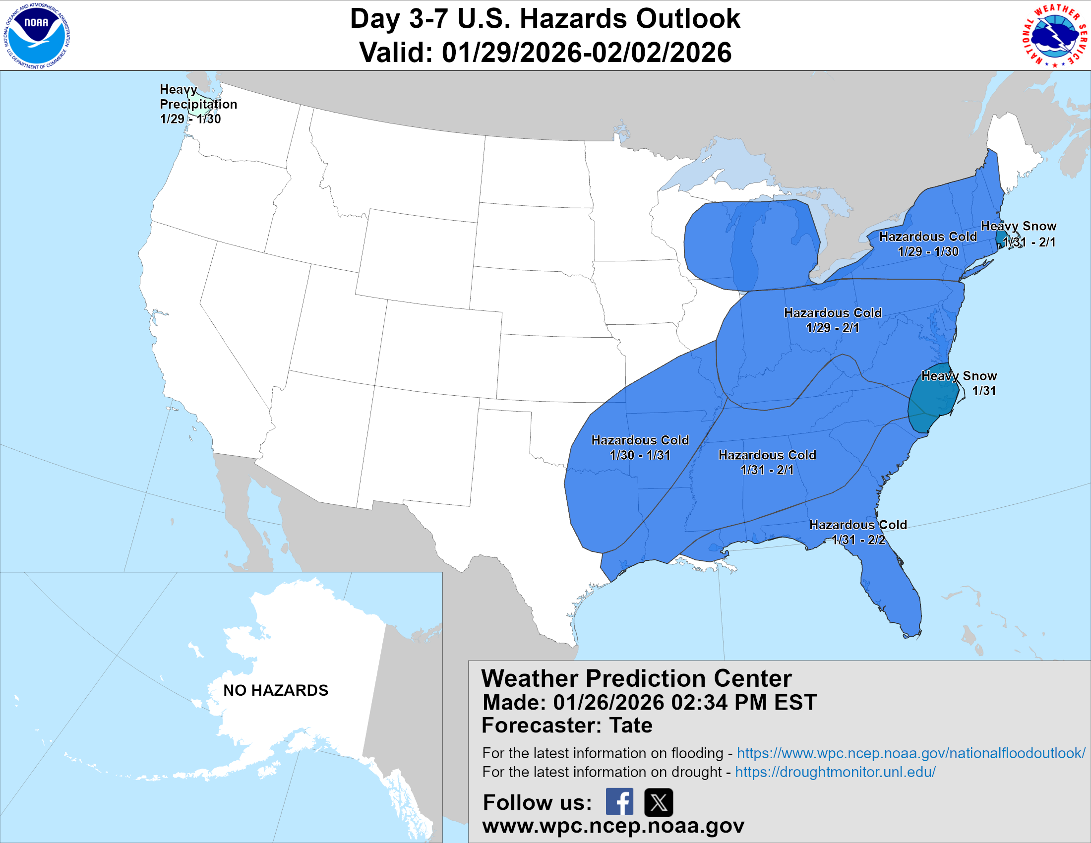
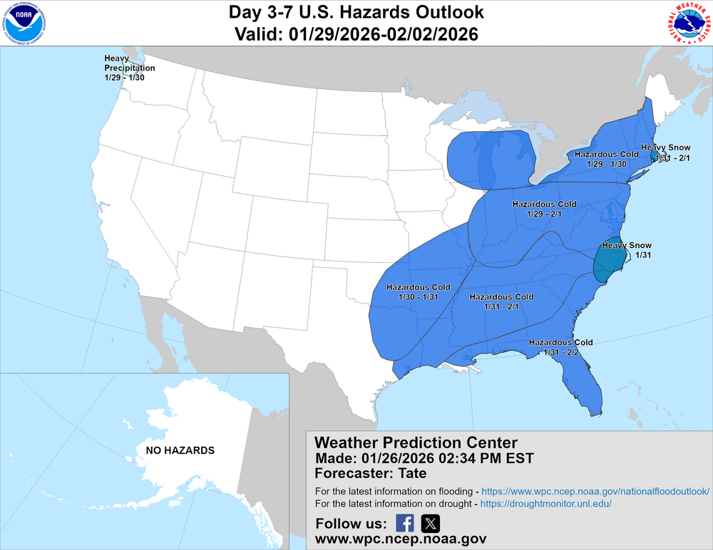
LWX AFD added a mention of the potential storm. KEY MESSAGE 3...The next round of winter weather is possible this weekend. A large scale, northern stream trough will dig south from the upper Great Lakes toward the central Appalachians this weekend. At the same time, a southern stream ejects from the Four Corners toward the Gulf states. As these systems phase along the Eastern Seaboard, there is good agreement that an area of low pressure develops along or near the coast. The location of the phasing will determine how close to the coast the low is. The long range models are painting a typical Miller A type Nor`easter that could bring wintry precipitation along some of the Mid-Atlantic coast. Cold air won't be an issue with an Arctic airmass leading up to the weekend (highs in the teens to low 20s Fri/Sat) and a reinforcing high building over southern Quebec/Ontario on Sunday. It is important to note that model uncertainty for any given solution is very high at 5-6 days out, but the ensemble guidance does hint at the possibility of some snow in the area this weekend. The 12Z European, GFS, and Canadian all have around a 20-30pct chance for 3" of snow east of the Blue Ridge. The NBM speak best to the wide range of possibilities for this system, with the 13Z run having a 20-30pct chance for 6" of snow, around 20pct chance for 12", around 15pct chance for 18", and around 5pct chance for 24". Expect model guidance to bounce around significantly over the next few days before settling on a solution by the end of this week. By Wednesday the regional models will have some output that goes into the weekend. For now, take note of this potential threat and continue to monitor for updates as the week progresses.
-
Is Norfolk in our "CWA"? How far south do we go?
-
about 130 ish hours hours out. we're much closer than we were last week when we started talking
-
Yep sorry, I'm too used to severe weather. First season going full weenie on the winter weather.
-

-
https://nvidia.github.io/earth2studio/ anyone with half a brain wanna figure this out?
-
Completely different type of system, though. Although I do feel models tend not to model lows deep enough, which also results in models coming in too southwest. Only from svwx experience though.
-
FWIW the SPC WPC introduced two areas of heavy snow associated with the potential nor'easter. edit: WPC not SPC
-
Apologize if this is stupid, but what's stopping them from just verbatim copying the GFS? AFAIK its public domain and, even if bad practice forecasting wise, would be leaps and bounds better than whatever they're doing right now.
-
Time to do the song and dance again! TWC and Crappuweather must pay Apple to make mets look bad.
-
To be fair, i'd rather this one start cutting west a little bit
-
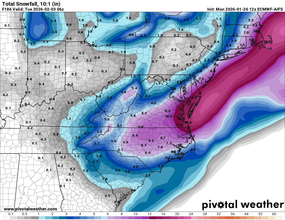
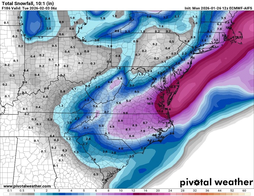
Here's AIFS verbatim. Probably add 50% to the totals to account for extremely good ratios.
-
I'm expecting the fam up north to get another dumping while we get nothing so I'll be pleasantly surprised if anything happens.
-
Aside from the fact that a 0.9" difference is literally just run to run noise, you're misusing the models. Euro and GFS aren't built to nowcast day-of events.
-
The Euro family is still by far the best model family available.
-
Super mixed bag. Can't really tell anything right now.
-
We still got like 20 more euro runs till any game time lol
-
For sure. I'd rather have the euro fam in our corner than the gfs fam.